Donaldson Peak

Log in to your account

AroundUs is a community-driven map of interesting places, built by curious explorers like you. It grows with every review, story, and photo you share.
Connect to save your favorite spots, contribute locations, and create personalized routes.
Continue with Google
Continue with Apple
Continue with X
Continue with Facebook
Continue with email
By continuing, you accept our Terms and Conditions and our Privacy Policy
Create an account
Add to collection
Map
Suggest a change
Share

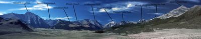
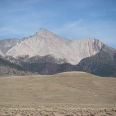
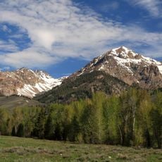
Donaldson Peak, Mountain summit in Lost River Range, Idaho, United States

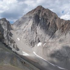
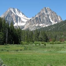
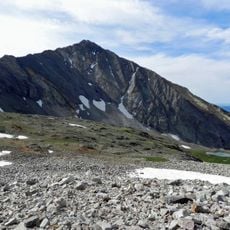
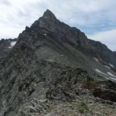
Donaldson Peak is a mountain summit in the Lost River Range and rises to approximately 12,000 feet in elevation. The peak features steep rock faces and talus slopes that create challenging climbing conditions.

The peak was named after Charles R. Donaldson, who served as Chief Justice of the Idaho Supreme Court from 1919 to 1987. This naming honors his long tenure and judicial contributions to the state.

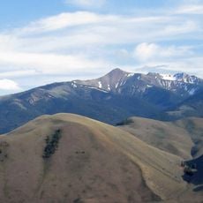
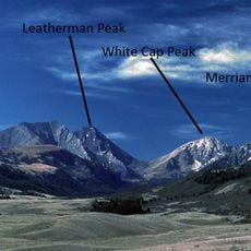
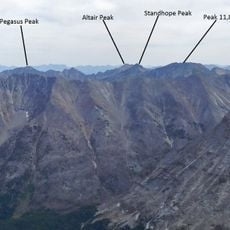
The mountain forms part of the Idaho 12ers, a group of nine peaks above 12,000 feet that attract mountaineers from across the country.

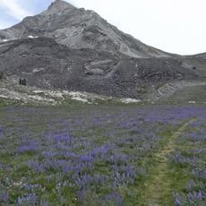
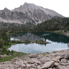
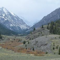
The mountain can be reached through two main routes: Jones Creek or North Fork Jones Creek, with the latter offering more stable ground conditions. Both paths require good endurance and scrambling experience.

The peak features two distinct climbing routes from its base pond, one following steep talus piles and another traversing exposed mountain ledges.

Location: Idaho

GPS coordinates: 44.06406,-113.70039

Latest update: December 14, 2025 20:03

Photos
Around this place
Craters of the Moon National Monument and Preserve
United States of America

Craters of the Moon National Monument and Preserve

68 km
Borah Peak
United States of America

Borah Peak

10.4 km
Hyndman Peak
United States of America

Hyndman Peak

49.2 km
Castle Peak
United States of America

Castle Peak

71 km
White Clouds Wilderness
United States of America

White Clouds Wilderness

72.5 km
Land of the Yankee Fork State Park
United States of America

Land of the Yankee Fork State Park

61.3 km
Birch Creek Charcoal Kilns
United States of America

Birch Creek Charcoal Kilns

49.9 km
Hemingway–Boulders Wilderness
United States of America

Hemingway–Boulders Wilderness

65.2 km
Mackay Reservoir
United States of America

Mackay Reservoir

12.5 km
Jim McClure–Jerry Peak Wilderness
United States of America

Jim McClure–Jerry Peak Wilderness

49.6 km
Ryan Peak
United States of America

Ryan Peak

59.6 km
Sawtooth Botanical Garden
United States of America

Sawtooth Botanical Garden

71.2 km
Merriam Peak
United States of America

Merriam Peak

70.4 km
USGS Peak
United States of America

USGS Peak

11.1 km
Mount Breitenbach
United States of America

Mount Breitenbach

2.2 km
Standhope Peak
United States of America

Standhope Peak

40.6 km
Kent Peak
United States of America

Kent Peak

59.5 km
Cobb Peak
United States of America

Cobb Peak

50.4 km
Old Hyndman Peak
United States of America

Old Hyndman Peak

49.1 km
Cold Springs Pegram Truss Railroad Bridge
United States of America

Cold Springs Pegram Truss Railroad Bridge

69.2 km
Glassford Peak
United States of America

Glassford Peak

64.8 km
Bruno Creek Tailings Impoundment
United States of America

Bruno Creek Tailings Impoundment

70.9 km
United States of America

Mackay Methodist Episcopal Church

18.3 km
Roundhouse Gondola
United States of America

Roundhouse Gondola

70.2 km
Thomas Chivers House
United States of America

Thomas Chivers House

65 km
Craters of the Moon National Monument Mission 66 Historic District
United States of America

Craters of the Moon National Monument Mission 66 Historic District

67.9 km
Bigwood Golf Course
United States of America

Bigwood Golf Course

67.4 km
Robert Limbert Visitor Center
United States of America

Robert Limbert Visitor Center

67.9 km
Show the full map
Reviews

Visited this place? Tap the stars to rate it and share your experience / photos with the community! Try now! You can cancel it anytime.

« Donaldson Peak - Mountain summit in Lost River Range, Idaho, United States » is provided by Around Us (aroundus.com). Images and texts are derived from Wikimedia project under a Creative Commons license. You are allowed to copy, distribute, and modify copies of this page, under the conditions set by the license, as long as this note is clearly visible.

Discover hidden gems everywhere you go!

From secret cafés to breathtaking viewpoints, skip the crowded tourist spots and find places that match your style. Our app makes it easy with voice search, smart filtering, route optimization, and insider tips from travelers worldwide. Download now for the complete mobile experience.

Around Us App Screenshot

A unique approach to discovering new places

Le Figaro

All the places worth exploring

France Info

A tailor-made excursion in just a few clicks

20 Minutes