Enable Location

We need your location to show you interesting places around you

Discover nearby places

Find interesting locations and hidden gems around you

Precise directions

Get accurate directions and distances to places

Your location is never shared with other users. It's only used when you tap the location button.

Mount Breitenbach

Log in to your account

Start exploring — it's free

Trusted by 61,351 travelers worldwide

Continue with Google
Continue with Apple
or

We will send you a code to connect

By continuing, you accept our Terms and Conditions and our Privacy Policy

Check your inbox

We've sent a pincode in your inbox. Please enter the code below.

Mount Breitenbach

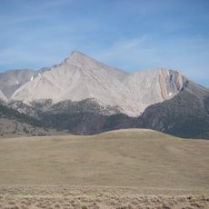
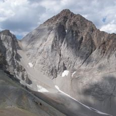
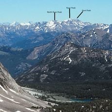
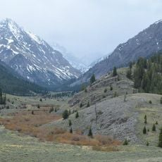
Mount Breitenbach, Rocky summit in Lost River Range, Idaho, USA.

Description

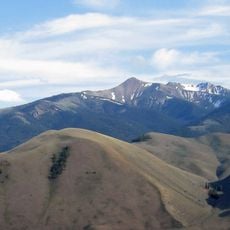
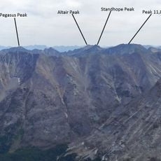
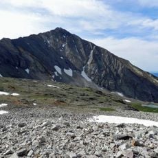
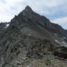
Mount Breitenbach stands in the Lost River Range of Idaho, reaching approximately 12,140 feet and ranking among the region's highest peaks. The mountain features multiple climbing approaches with steep sections and alpine terrain.

History

The summit was named in 1963 to honor Jake Breitenbach, a climber who died during the American expedition to Mount Everest that year. His legacy remains tied to this remote Idaho peak.

Culture

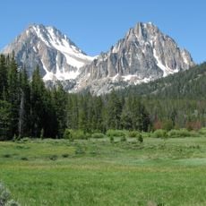
This peak draws mountaineers who come to test themselves on established climbing routes through the remote wilderness. The mountain has become a destination for climbers seeking a significant challenge in the Idaho backcountry.

Practical

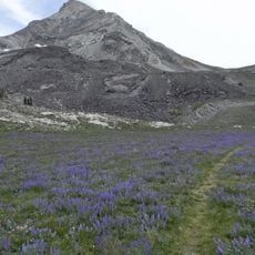
The climbing season runs from mid-June through mid-September when snow melts and routes become most passable. Earlier in the season, heavy snow coverage makes the approach significantly more difficult.

Did you know?

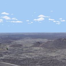
The southwestern slopes rise nearly 1,890 meters (6,200 feet) above the Big Lost River Valley in a single massive wall. The northern face drops sharply toward the East Fork Pasimeroi River, creating a distinctive triangular profile when viewed from different angles.

Location
GPS coordinates
44.06506,-113.67296
Latest update
December 14, 2025 20:32

AroundUs brings together thousands of curated places, local tips, and hidden gems, enriched daily by 60,000 contributors worldwide. Discover all places nearby (Idaho).

Around this place
Craters of the Moon National Monument and Preserve
United States of America

Craters of the Moon National Monument and Preserve

67.7 km
Borah Peak
United States of America

Borah Peak

11.8 km
Bald Mountain
United States of America

Bald Mountain

74.7 km
Hyndman Peak
United States of America

Hyndman Peak

50.8 km
Castle Peak
United States of America

Castle Peak

73.2 km
Land of the Yankee Fork State Park
United States of America

Land of the Yankee Fork State Park

62.7 km
Birch Creek Charcoal Kilns
United States of America

Birch Creek Charcoal Kilns

48 km
Hemingway–Boulders Wilderness
United States of America

Hemingway–Boulders Wilderness

67.3 km
Mackay Reservoir
United States of America

Mackay Reservoir

12.5 km
Jim McClure–Jerry Peak Wilderness
United States of America

Jim McClure–Jerry Peak Wilderness

51.8 km
Ryan Peak
United States of America

Ryan Peak

61.7 km
Sawtooth Botanical Garden
United States of America

Sawtooth Botanical Garden

72.9 km
Merriam Peak
United States of America

Merriam Peak

72.6 km
USGS Peak
United States of America

USGS Peak

9.4 km
Standhope Peak
United States of America

Standhope Peak

42.1 km
Kent Peak
United States of America

Kent Peak

61.6 km
Cobb Peak
United States of America

Cobb Peak

52 km
Donaldson Peak
United States of America

Donaldson Peak

2.2 km
Old Hyndman Peak
United States of America

Old Hyndman Peak

50.7 km
Cold Springs Pegram Truss Railroad Bridge
United States of America

Cold Springs Pegram Truss Railroad Bridge

71 km
Glassford Peak
United States of America

Glassford Peak

67 km
United States of America

Mackay Methodist Episcopal Church

17.6 km
Roundhouse Gondola
United States of America

Roundhouse Gondola

72 km
Thomas Chivers House
United States of America

Thomas Chivers House

66.4 km
Craters of the Moon National Monument Mission 66 Historic District
United States of America

Craters of the Moon National Monument Mission 66 Historic District

67.7 km
Bigwood Golf Course
United States of America

Bigwood Golf Course

69.3 km
Craters of the Moon
United States of America

Craters of the Moon

73.1 km
Robert Limbert Visitor Center
United States of America

Robert Limbert Visitor Center

67.7 km
Show the full map
« Mount Breitenbach - Rocky summit in Lost River Range, Idaho, USA » is provided by Around Us (aroundus.com). Images and texts are derived from Wikimedia project under a Creative Commons license. You are allowed to copy, distribute, and modify copies of this page, under the conditions set by the license, as long as this note is clearly visible.

Discover hidden gems everywhere you go!

From secret cafés to breathtaking viewpoints, skip the crowded tourist spots and find places that match your style. Our app makes it easy with voice search, smart filtering, route optimization, and insider tips from travelers worldwide. Download now for the complete mobile experience.

Around Us App Screenshot

A unique approach to discovering new places

Le Figaro

All the places worth exploring

France Info

A tailor-made excursion in just a few clicks

20 Minutes

Around Us
Travel Guide & Maps
Download

Send to your phone

QR Code
1

Open the camera app on your mobile.

2

Point at the QR code with your camera. A notification will appear.

3

Tap the notification to open the link.