Enable Location

We need your location to show you interesting places around you

Discover nearby places

Find interesting locations and hidden gems around you

Precise directions

Get accurate directions and distances to places

Your location is never shared with other users. It's only used when you tap the location button.

USGS Peak

Log in to your account

Start exploring — it's free

Trusted by 61,514 travelers worldwide

Continue with Google
Continue with Apple
or

We will send you a code to connect

By continuing, you accept our Terms and Conditions and our Privacy Policy

Check your inbox

We've sent a pincode in your inbox. Please enter the code below.

USGS Peak

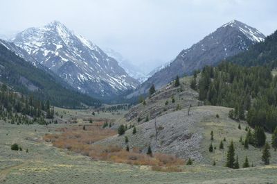
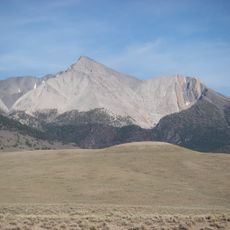
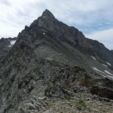
USGS Peak, Mountain summit in Lost River Range, Idaho.

Description

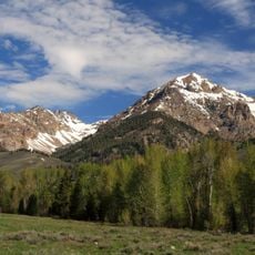
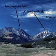
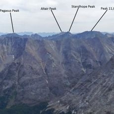
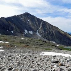
USGS Peak is a mountain summit in the Lost River Range that rises to approximately 11,982 feet. Its steep limestone walls and dramatic rock formations make it one of the most distinctive peaks in the central Idaho wilderness.

History

The peak was named and measured by the United States Geological Survey during the early 1900s, when initial height recordings required later adjustment. This reflects how surveying methods and accuracy improved over time in the remote mountain regions.

Culture

Local farmers from the region documented the peak's limited early ascents, with Tom Lopez and D. Hanson completing the first recorded North Face climb.

Practical

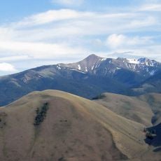
The standard route involves a multi-mile hike with significant elevation gain that requires climbing experience and good physical fitness to complete. Summer months provide the safest and most accessible conditions for attempting the climb.

Did you know?

The summit features two USGS benchmarks that were installed as reference points for surveyors. These markers remain visible today and serve as reminders of the early mapping efforts in this remote area.

Location
GPS coordinates
44.01309,-113.58117
Latest update
December 14, 2025 18:12

AroundUs brings together thousands of curated places, local tips, and hidden gems, enriched daily by 60,000 contributors worldwide. Discover all places nearby (Idaho).

Around this place
Craters of the Moon National Monument and Preserve
United States of America

Craters of the Moon National Monument and Preserve

61.4 km
Experimental Breeder Reactor I
United States of America

Experimental Breeder Reactor I

72.5 km
Borah Peak
United States of America

Borah Peak

21.1 km
Bayhorse
United States of America

Bayhorse

72.4 km
Hyndman Peak
United States of America

Hyndman Peak

53 km
Land of the Yankee Fork State Park
United States of America

Land of the Yankee Fork State Park

71.9 km
Birch Creek Charcoal Kilns
United States of America

Birch Creek Charcoal Kilns

46.2 km
Hemingway–Boulders Wilderness
United States of America

Hemingway–Boulders Wilderness

73.3 km
Mackay Reservoir
United States of America

Mackay Reservoir

10 km
Jim McClure–Jerry Peak Wilderness
United States of America

Jim McClure–Jerry Peak Wilderness

58.9 km
Ryan Peak
United States of America

Ryan Peak

67.5 km
Sawtooth Botanical Garden
United States of America

Sawtooth Botanical Garden

75.1 km
Gimlet Pegram Truss Railroad Bridge
United States of America

Gimlet Pegram Truss Railroad Bridge

76.9 km
Mount Breitenbach
United States of America

Mount Breitenbach

9.4 km
Standhope Peak
United States of America

Standhope Peak

43.8 km
Kent Peak
United States of America

Kent Peak

67.3 km
Cobb Peak
United States of America

Cobb Peak

53.9 km
Donaldson Peak
United States of America

Donaldson Peak

11.1 km
Old Hyndman Peak
United States of America

Old Hyndman Peak

52.6 km
Cold Springs Pegram Truss Railroad Bridge
United States of America

Cold Springs Pegram Truss Railroad Bridge

73.5 km
Glassford Peak
United States of America

Glassford Peak

73 km
United States of America

Mackay Methodist Episcopal Church

11.3 km
Roundhouse Gondola
United States of America

Roundhouse Gondola

74.8 km
Thomas Chivers House
United States of America

Thomas Chivers House

75.6 km
Craters of the Moon National Monument Mission 66 Historic District
United States of America

Craters of the Moon National Monument Mission 66 Historic District

61.4 km
Bigwood Golf Course
United States of America

Bigwood Golf Course

72.3 km
Little Wood River Reservoir
United States of America

Little Wood River Reservoir

73.3 km
Craters of the Moon
United States of America

Craters of the Moon

66.3 km
Show the full map
« USGS Peak - Mountain summit in Lost River Range, Idaho » is provided by Around Us (aroundus.com). Images and texts are derived from Wikimedia project under a Creative Commons license. You are allowed to copy, distribute, and modify copies of this page, under the conditions set by the license, as long as this note is clearly visible.

Discover hidden gems everywhere you go!

From secret cafés to breathtaking viewpoints, skip the crowded tourist spots and find places that match your style. Our app makes it easy with voice search, smart filtering, route optimization, and insider tips from travelers worldwide. Download now for the complete mobile experience.

Around Us App Screenshot

A unique approach to discovering new places

Le Figaro

All the places worth exploring

France Info

A tailor-made excursion in just a few clicks

20 Minutes

Around Us
Travel Guide & Maps
Download

Send to your phone

QR Code
1

Open the camera app on your mobile.

2

Point at the QR code with your camera. A notification will appear.

3

Tap the notification to open the link.