Enable Location

We need your location to show you interesting places around you

Discover nearby places

Find interesting locations and hidden gems around you

Precise directions

Get accurate directions and distances to places

Your location is never shared with other users. It's only used when you tap the location button.

Wallowa Mountains

Log in to your account

Start exploring — it's free

Trusted by 61,777 travelers worldwide

Continue with Google
Continue with Apple
or

We will send you a code to connect

By continuing, you accept our Terms and Conditions and our Privacy Policy

Check your inbox

We've sent a pincode in your inbox. Please enter the code below.

Wallowa Mountains

Wallowa Mountains, Mountain range in northeastern Oregon, United States

Description

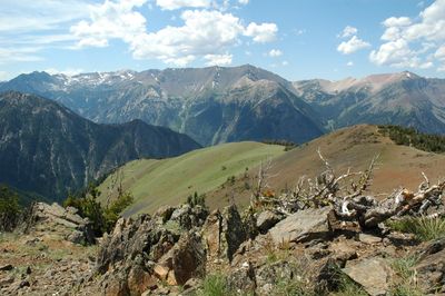
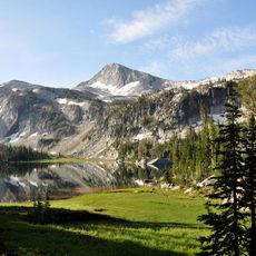
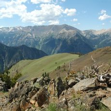
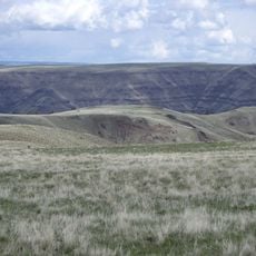
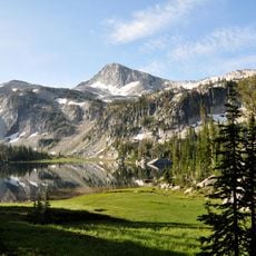
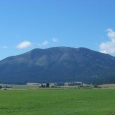
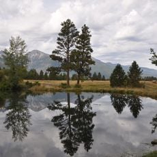
The Wallowa Mountains are a granite mountain range stretching across northeastern Oregon for about 40 miles, with Sacajawea Peak rising to 9,838 feet as the highest point. The range encompasses a large wilderness area filled with alpine lakes, glacial canyons, and numerous ridges that define the landscape.

History

The Nez Perce people lived in Wallowa Valley for generations until European settlers arrived in the 1870s, creating conflict. This tension led to the Nez Perce War of 1877, which reshaped the entire region.

Culture

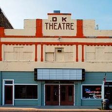
The town of Joseph nearby hosts galleries and bronze workshops that still operate today, showing how local craftspeople engage with the region's artistic heritage. Visitors can watch artisans at work and see how this tradition shapes daily life in the valley.

Practical

More than 500 miles of hiking trails connect the wilderness area, offering access to lakes, canyons, and peaks, with summer through early fall being the best hiking season. The terrain varies from steep mountain paths to gentler trails, so visitors can choose routes matching their fitness level.

Did you know?

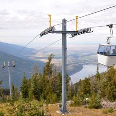
A tramway carries visitors 3,700 feet up to Mount Howard, where views stretch across three states. This high vantage point makes alpine hiking accessible without a lengthy ascent on foot.

Location
Made from material
granite
Part of
Columbia Plateau
GPS coordinates
45.24000,-117.30000
Latest update
December 7, 2025 10:05

AroundUs brings together thousands of curated places, local tips, and hidden gems, enriched daily by 60,000 contributors worldwide. Discover all places nearby (Oregon).

Around this place
Eagle Cap Wilderness
United States of America

Eagle Cap Wilderness

11.1 km
Sacajawea Peak
United States of America

Sacajawea Peak

764 m
Hells Canyon Dam
United States of America

Hells Canyon Dam

47.2 km
Zumwalt Prairie
United States of America

Zumwalt Prairie

37.2 km
Wallowa Lake Tramway
United States of America

Wallowa Lake Tramway

9.7 km
Wallowa Lake State Park
United States of America

Wallowa Lake State Park

7.6 km
Catherine Creek State Park
United States of America

Catherine Creek State Park

35.6 km
Eagle Cap
United States of America

Eagle Cap

8.5 km
Mount Howard
United States of America

Mount Howard

9.8 km
Wallowa River Rest Area
United States of America

Wallowa River Rest Area

48.1 km
Cove Hot Springs Pool
United States of America

Cove Hot Springs Pool

40.7 km
Iwetemlaykin State Heritage Site
United States of America

Iwetemlaykin State Heritage Site

12.8 km
Thief Valley Reservoir
United States of America

Thief Valley Reservoir

45.9 km
Wallowa County Courthouse
United States of America

Wallowa County Courthouse

20.7 km
OK Theatre
United States of America

OK Theatre

20.7 km
Abel E. Eaton House
United States of America

Abel E. Eaton House

44.4 km
Wallowa Ranger Station
United States of America

Wallowa Ranger Station

41 km
Ascension Episcopal Church
United States of America

Ascension Episcopal Church

40.6 km
College Creek Ranger Station
United States of America

College Creek Ranger Station

45.7 km
William P. Warnock House
United States of America

William P. Warnock House

20.3 km
First Bank of Joseph
United States of America

First Bank of Joseph

13.5 km
Enterprise Public Library
United States of America

Enterprise Public Library

20.8 km
Flora School
United States of America

Flora School

19.4 km
Dr. J. W. Barnard Building and First National Bank of Joseph
United States of America

Dr. J. W. Barnard Building and First National Bank of Joseph

13.7 km
Lick Creek Guard Station
United States of America

Lick Creek Guard Station

22.7 km
Alvin M. and Betty Josephy Library of Western History and Culture
United States of America

Alvin M. and Betty Josephy Library of Western History and Culture

14 km
Enterprise I.O.O.F. Hall
United States of America

Enterprise I.O.O.F. Hall

20.8 km
Hunter–Morelock House
United States of America

Hunter–Morelock House

40.7 km
Show the full map
« Wallowa Mountains - Mountain range in northeastern Oregon, United States » is provided by Around Us (aroundus.com). Images and texts are derived from Wikimedia project under a Creative Commons license. You are allowed to copy, distribute, and modify copies of this page, under the conditions set by the license, as long as this note is clearly visible.

Discover hidden gems everywhere you go!

From secret cafés to breathtaking viewpoints, skip the crowded tourist spots and find places that match your style. Our app makes it easy with voice search, smart filtering, route optimization, and insider tips from travelers worldwide. Download now for the complete mobile experience.

Around Us App Screenshot

A unique approach to discovering new places

Le Figaro

All the places worth exploring

France Info

A tailor-made excursion in just a few clicks

20 Minutes

Around Us
Travel Guide & Maps
Download

Send to your phone

QR Code
1

Open the camera app on your mobile.

2

Point at the QR code with your camera. A notification will appear.

3

Tap the notification to open the link.