Enable Location

We need your location to show you interesting places around you

Discover nearby places

Find interesting locations and hidden gems around you

Precise directions

Get accurate directions and distances to places

Your location is never shared with other users. It's only used when you tap the location button.

Wallowa Lake State Park

Log in to your account

Start exploring — it's free

Trusted by 65,419 travelers worldwide

Continue with Google
Continue with Apple
or

We will send you a code to connect

By continuing, you accept our Terms and Conditions and our Privacy Policy

Check your inbox

We've sent a pincode in your inbox. Please enter the code below.

Wallowa Lake State Park
Discussion Reviews 1 Photos
4.4k Popularity

Wallowa Lake State Park, State park at Wallowa Lake, Oregon, US

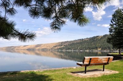
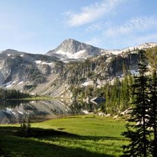
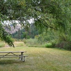
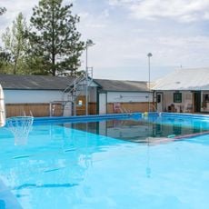
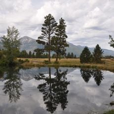
Wallowa Lake State Park is an Oregon state park on the southern shore of a glacial lake in the Wallowa Mountains, in the northeastern corner of the state. It covers sandy beach areas, forested hillsides, picnic grounds, and camping zones that run along the water's edge.

The Nez Perce people lived around this lake and the surrounding mountains for centuries before settlers arrived in the mid-1800s, drawn by the fertile valley below. The state gradually acquired land in the following decades to create the park that visitors know today.

The name Wallowa comes from the Nez Perce language and is thought to refer to a fish trap made of stakes and line, reflecting how the tribe used these waters. Near the south end of the lake, a small monument marks the connection between this land and the people who lived here long before it became a park.

The park gets busy in summer, so booking a campsite well ahead of your visit is a good idea, especially for weekends. Arriving in the morning gives you the best chance of finding parking close to the beach and lake access points.

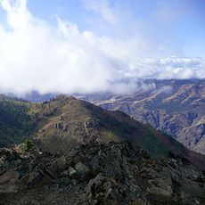
The lake sits at the end of a valley shaped by a glacier that left two large moraines still visible on either side of the southern shore. These low ridges frame the water and give the valley its narrow, enclosed shape that you notice as soon as you arrive.

The community of curious travelers

AroundUs brings together thousands of curated places, local tips, and hidden gems, enriched daily by 60,000 contributors worldwide.

Start exploring
Location
GPS coordinates
45.26880,-117.21200
Latest update
March 3, 2026 08:10
Around this place
Hells Canyon
United States of America

Hells Canyon

46.4 km
Wallowa Mountains
United States of America

Wallowa Mountains

7.6 km
Eagle Cap Wilderness
United States of America

Eagle Cap Wilderness

18.3 km
Sacajawea Peak
United States of America

Sacajawea Peak

6.9 km
Hells Canyon Dam
United States of America

Hells Canyon Dam

40.4 km
Zumwalt Prairie
United States of America

Zumwalt Prairie

31.7 km
Wallowa Lake Tramway
United States of America

Wallowa Lake Tramway

2.5 km
Catherine Creek State Park
United States of America

Catherine Creek State Park

43.1 km
Eagle Cap
United States of America

Eagle Cap

13.7 km
Mount Howard
United States of America

Mount Howard

2.8 km
Wallowa River Rest Area
United States of America

Wallowa River Rest Area

49.6 km
Cove Hot Springs Pool
United States of America

Cove Hot Springs Pool

47.2 km
Iwetemlaykin State Heritage Site
United States of America

Iwetemlaykin State Heritage Site

8.2 km
Sheep Rock
United States of America

Sheep Rock

43.3 km
Wallowa County Courthouse
United States of America

Wallowa County Courthouse

18.1 km
OK Theatre
United States of America

OK Theatre

18.2 km
Wallowa Ranger Station
United States of America

Wallowa Ranger Station

41.9 km
Ascension Episcopal Church
United States of America

Ascension Episcopal Church

47.1 km
College Creek Ranger Station
United States of America

College Creek Ranger Station

38.1 km
William P. Warnock House
United States of America

William P. Warnock House

17.5 km
First Bank of Joseph
United States of America

First Bank of Joseph

9.2 km
Enterprise Public Library
United States of America

Enterprise Public Library

18.2 km
Flora School
United States of America

Flora School

17.8 km
Dr. J. W. Barnard Building and First National Bank of Joseph
United States of America

Dr. J. W. Barnard Building and First National Bank of Joseph

9.3 km
Lick Creek Guard Station
United States of America

Lick Creek Guard Station

18.4 km
Alvin M. and Betty Josephy Library of Western History and Culture
United States of America

Alvin M. and Betty Josephy Library of Western History and Culture

9.8 km
Enterprise I.O.O.F. Hall
United States of America

Enterprise I.O.O.F. Hall

18.2 km
Hunter–Morelock House
United States of America

Hunter–Morelock House

41.5 km
Show the full map
Reviews
Share your experience

No review yet

Discussions
Start a discussion...

No discussion yet

« Wallowa Lake State Park - State park at Wallowa Lake, Oregon, US » is provided by Around Us (aroundus.com). Images and texts are derived from Wikimedia project under a Creative Commons license. You are allowed to copy, distribute, and modify copies of this page, under the conditions set by the license, as long as this note is clearly visible.

Discover hidden gems everywhere you go!

From secret cafés to breathtaking viewpoints, skip the crowded tourist spots and find places that match your style. Our app makes it easy with voice search, smart filtering, route optimization, and insider tips from travelers worldwide. Download now for the complete mobile experience.

Around Us App Screenshot

A unique approach to discovering new places

Le Figaro

All the places worth exploring

France Info

A tailor-made excursion in just a few clicks

20 Minutes

Around Us
Travel Guide & Maps
Download

Send to your phone

QR Code
1

Open the camera app on your mobile.

2

Point at the QR code with your camera. A notification will appear.

3

Tap the notification to open the link.