Enable Location

We need your location to show you interesting places around you

Discover nearby places

Find interesting locations and hidden gems around you

Precise directions

Get accurate directions and distances to places

Your location is never shared with other users. It's only used when you tap the location button.

Wallowa Lake Tramway

Log in to your account

Start exploring — it's free

Trusted by 63,028 travelers worldwide

Continue with Google
Continue with Apple
or

We will send you a code to connect

By continuing, you accept our Terms and Conditions and our Privacy Policy

Check your inbox

We've sent a pincode in your inbox. Please enter the code below.

Wallowa Lake Tramway
Discussion Reviews 1 Photos
4.4k Popularity

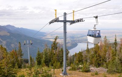
Wallowa Lake Tramway, Aerial tramway in Joseph, Oregon.

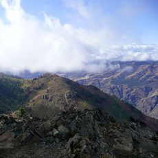
The Wallowa Lake Tramway carries passengers up 3,700 vertical feet in approximately 15 minutes, offering panoramic views of Wallowa Lake, the surrounding valley, and the Eagle Cap Wilderness mountain ranges from its gondola cabins.

Built in 1970, this tramway was constructed to provide easier access to Mount Howard's summit, replacing the previously difficult hiking routes and becoming one of Wallowa County's most popular tourist attractions within its first decade of operation.

The tramway provides access to lands historically used by the Nez Perce tribe for centuries, while the valley below served as summer grounds for Chief Joseph and his people before European settlement transformed the region.

Operating seasonally from May through September, the tramway runs daily with varying schedules, features accessible facilities for mobility-impaired visitors, and offers mountain bike transport services for downhill trail adventures.

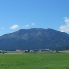
This gondola system claims to be the steepest vertical aerial tramway in North America, ascending to over 8,150 feet elevation where visitors can dine at the Summit Grill, marketed as the Northwest's highest restaurant.

The community of curious travelers

AroundUs brings together thousands of curated places, local tips, and hidden gems, enriched daily by 60,000 contributors worldwide.

Start exploring
Location
GPS coordinates
45.26350,-117.18100
Latest update
July 25, 2025 20:35
Around this place
Hells Canyon
United States of America

Hells Canyon

44.2 km
Wallowa Mountains
United States of America

Wallowa Mountains

9.7 km
Eagle Cap Wilderness
United States of America

Eagle Cap Wilderness

20.6 km
Sacajawea Peak
United States of America

Sacajawea Peak

9 km
Hells Canyon Dam
United States of America

Hells Canyon Dam

37.9 km
Zumwalt Prairie
United States of America

Zumwalt Prairie

31.6 km
Wallowa Lake State Park
United States of America

Wallowa Lake State Park

2.5 km
Catherine Creek State Park
United States of America

Catherine Creek State Park

45.3 km
Eagle Cap
United States of America

Eagle Cap

14.6 km
Mount Howard
United States of America

Mount Howard

362 m
Cove Hot Springs Pool
United States of America

Cove Hot Springs Pool

49.7 km
Iwetemlaykin State Heritage Site
United States of America

Iwetemlaykin State Heritage Site

9.3 km
Sheep Rock
United States of America

Sheep Rock

40.8 km
Wallowa County Courthouse
United States of America

Wallowa County Courthouse

19.5 km
OK Theatre
United States of America

OK Theatre

19.6 km
Wallowa Ranger Station
United States of America

Wallowa Ranger Station

43.9 km
Ascension Episcopal Church
United States of America

Ascension Episcopal Church

49.6 km
College Creek Ranger Station
United States of America

College Creek Ranger Station

36.3 km
William P. Warnock House
United States of America

William P. Warnock House

18.8 km
First Bank of Joseph
United States of America

First Bank of Joseph

10.4 km
Enterprise Public Library
United States of America

Enterprise Public Library

19.5 km
Flora School
United States of America

Flora School

19.5 km
Dr. J. W. Barnard Building and First National Bank of Joseph
United States of America

Dr. J. W. Barnard Building and First National Bank of Joseph

10.5 km
Lick Creek Guard Station
United States of America

Lick Creek Guard Station

16.2 km
Alvin M. and Betty Josephy Library of Western History and Culture
United States of America

Alvin M. and Betty Josephy Library of Western History and Culture

11 km
Enterprise I.O.O.F. Hall
United States of America

Enterprise I.O.O.F. Hall

19.6 km
Hunter–Morelock House
United States of America

Hunter–Morelock House

43.4 km
Hat Point Fire Lookout Tower
United States of America

Hat Point Fire Lookout Tower

45 km
Show the full map
Reviews
Share your experience

No review yet

Discussions
Start a discussion...

No discussion yet

« Wallowa Lake Tramway - Aerial tramway in Joseph, Oregon » is provided by Around Us (aroundus.com). Images and texts are derived from Wikimedia project under a Creative Commons license. You are allowed to copy, distribute, and modify copies of this page, under the conditions set by the license, as long as this note is clearly visible.

Discover hidden gems everywhere you go!

From secret cafés to breathtaking viewpoints, skip the crowded tourist spots and find places that match your style. Our app makes it easy with voice search, smart filtering, route optimization, and insider tips from travelers worldwide. Download now for the complete mobile experience.

Around Us App Screenshot

A unique approach to discovering new places

Le Figaro

All the places worth exploring

France Info

A tailor-made excursion in just a few clicks

20 Minutes

Around Us
Travel Guide & Maps
Download

Send to your phone

QR Code
1

Open the camera app on your mobile.

2

Point at the QR code with your camera. A notification will appear.

3

Tap the notification to open the link.