Chest opened
+${chestReward.xp} XP
Explorer
NOUVEAU ×${chestReward.collectible.quantity}
tapez pour fermer
Chest locked

Open chests in the app

Around Us is built for your phone — chests unlock when you walk, explore and capture nearby places.

Enable Location

We need your location to show you interesting places around you

Discover nearby places

Find interesting locations and hidden gems around you

Precise directions

Get accurate directions and distances to places

Your location is never shared with other users. It's only used when you tap the location button.

Cranberry Glades

Log in to your account

Start exploring — it's free

Trusted by 72,878 travelers worldwide

Continue with Google
Continue with Apple
or

We will send you a code to connect

By continuing, you accept our Terms and Conditions and our Privacy Policy

Check your inbox

We've sent a pincode in your inbox. Please enter the code below.

Cranberry Glades
Discussion Reviews 1 Photos
12.6k Popularity

Cranberry Glades, Wetland ecosystem in Pocahontas County, United States

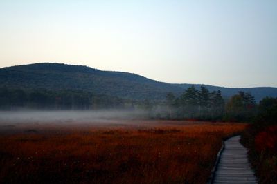
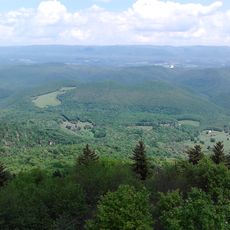
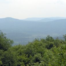
Cranberry Glades is a wetland containing five distinct bogs that spread across 750 acres within the Monongahela National Forest. The site sits at a higher elevation in a mountainous region and supports a specialized plant community adapted to waterlogged, acidic conditions.

The bogs formed more than 12,000 years ago after the Last Glacial Period, when coniferous forests gradually replaced the tundra that had covered the land. This long span of time created the layered peat deposits and specialized plant communities visible in the wetlands today.

The location appears in Tyler Childers' song 'Universal Sound' and inspired the Cranberry Bog in the video game Fallout 76. These cultural references show how the wetlands capture the imagination of local and digital creators.

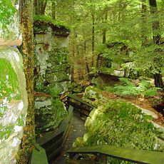
A wooden boardwalk about half a mile long leads visitors through the site while protecting the sensitive plants beneath their feet. Wear sturdy shoes and be prepared for wet, muddy ground throughout the visit.

Two carnivorous plant species, purple pitcher plants and sundews, thrive here at their southernmost natural range in North America. These meat-eating plants have adapted to the nutrient-poor conditions and offer an unexpected glimpse into bog ecology.

The community of curious travelers

AroundUs brings together thousands of curated places, local tips, and hidden gems, enriched daily by 60,000 contributors worldwide.

Start exploring
Elevation above the sea
1,024 m
GPS coordinates
38.20310,-80.26640
Latest update
December 7, 2025 20:44
Around this place
Cass Scenic Railroad State Park
United States of America

Cass Scenic Railroad State Park

37.5 km
Lost World Caverns
United States of America

Lost World Caverns

44.2 km
Greenbrier River Trail
United States of America

Greenbrier River Trail

15.2 km
Bald Knob
United States of America

Bald Knob

40 km
Cranberry Wilderness
United States of America

Cranberry Wilderness

10 km
Beartown State Park
United States of America

Beartown State Park

16.8 km
Watoga State Park
United States of America

Watoga State Park

15.1 km
Gathright Dam
United States of America

Gathright Dam

39.1 km
Droop Mountain Battlefield State Park
United States of America

Droop Mountain Battlefield State Park

10.4 km
Pearl S. Buck Birthplace
United States of America

Pearl S. Buck Birthplace

8.7 km
Big Draft Wilderness
United States of America

Big Draft Wilderness

31.4 km
Spice Run Wilderness
United States of America

Spice Run Wilderness

18 km
Seneca State Forest
United States of America

Seneca State Forest

32.1 km
Renick Farm
United States of America

Renick Farm

25.6 km
Barton Lodge
United States of America

Barton Lodge

44.3 km
Hidden Valley
United States of America

Hidden Valley

41 km
Sunshine Farm and Gardens
United States of America

Sunshine Farm and Gardens

21.4 km
Morton House
United States of America

Morton House

32.8 km
Pocahontas County Opera House
United States of America

Pocahontas County Opera House

15.2 km
Switchback School
United States of America

Switchback School

42.8 km
Frank and Anna Hunter House
United States of America

Frank and Anna Hunter House

14.6 km
Pocahontas County Courthouse and Jail
United States of America

Pocahontas County Courthouse and Jail

15.7 km
Edgefield
United States of America

Edgefield

24.3 km
Cass Historic District
United States of America

Cass Historic District

36.9 km
United States of America

Pleasant Green Methodist Episcopal Church

9.6 km
Downtown Richwood Historic District
United States of America

Downtown Richwood Historic District

23.5 km
IOOF Lodge Building
United States of America

IOOF Lodge Building

15.2 km
McClung's Price Place
United States of America

McClung's Price Place

36.8 km
Show the full map
Reviews
Share your experience

No review yet

Discussions
Start a discussion...

No discussion yet

« Cranberry Glades - Wetland ecosystem in Pocahontas County, United States » is provided by Around Us (aroundus.com). Images and texts are derived from Wikimedia project under a Creative Commons license. You are allowed to copy, distribute, and modify copies of this page, under the conditions set by the license, as long as this note is clearly visible.

Discover hidden gems everywhere you go!

From secret cafés to breathtaking viewpoints, skip the crowded tourist spots and find places that match your style. Our app makes it easy with voice search, smart filtering, route optimization, and insider tips from travelers worldwide. Download now for the complete mobile experience.

Around Us App Screenshot

A unique approach to discovering new places

Le Figaro

All the places worth exploring

France Info

A tailor-made excursion in just a few clicks

20 Minutes

Around Us
Travel Guide & Maps
Download

Send to your phone

QR Code
1

Open the camera app on your mobile.

2

Point at the QR code with your camera. A notification will appear.

3

Tap the notification to open the link.