Chest opened
+${chestReward.xp} XP
Explorer
NOUVEAU ×${chestReward.collectible.quantity}
tapez pour fermer

See the monuments around you in AR Open chests in the app

Around Us is built for your phone — point your camera at the streets and discover the monuments and places around you in augmented reality. Around Us is built for your phone — chests unlock when you walk, explore and capture nearby places.

Enable Location

We need your location to show you interesting places around you

Discover nearby places

Find interesting locations and hidden gems around you

Precise directions

Get accurate directions and distances to places

Your location is never shared with other users. It's only used when you tap the location button.

Log in to your account

Start exploring — it's free

Trusted by 83,375 travelers worldwide

Continue with Google
Continue with Apple
or

We will send you a code to connect

By continuing, you accept our Terms and Conditions and our Privacy Policy

Check your inbox

We've sent a pincode in your inbox. Please enter the code below.

Craters of the Moon National Wilderness
Discussion Reviews Photo
2.4k Popularity

Craters of the Moon National Wilderness, Volcanic wilderness area in Snake River Plain, Idaho.

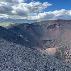
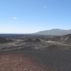
Craters of the Moon National Wilderness is a protected area spanning 43,000 acres of dark volcanic rock in southern Idaho with numerous cinder cones and deep rift cracks across the landscape. The terrain displays volcanic activity everywhere, with lava fields and fissures that extend across vast distances.

The region was shaped by volcanic eruptions roughly 2,000 to 2,500 years ago that created the black lava landscape visible today. Later, local peoples used these volcanic fields as travel routes, as evidenced by ancient stone circles still visible in the area.

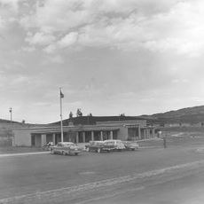
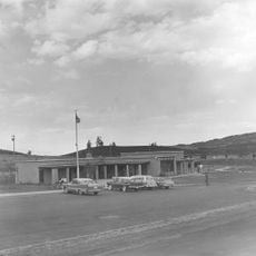
The Robert Limbert Visitor Center displays educational exhibits about regional geology and the local environment that visitors can observe firsthand while walking through the landscape. These resources help people understand the volcanic formations and natural patterns they encounter throughout the area.

Visitors should bring plenty of water since no water sources exist in the area and the heat can be intense across the open volcanic landscape. Overnight stays require a free permit, which is available at the visitor center.

The area contains one of the deepest known volcanic rift cracks on Earth, plunging over 200 meters (800 feet) deep in places and sheltering specialized animals. These extreme habitats support plants and insects found nowhere else in the region.

The community of curious travelers

AroundUs brings together thousands of curated places, local tips, and hidden gems, enriched daily by 60,000 contributors worldwide.

Start exploring
Location
GPS coordinates
43.40000,-113.50000
Latest update
August 12, 2026 11:38
Around this place
Craters of the Moon National Monument and Preserve
United States of America

Craters of the Moon National Monument and Preserve

8.6 km
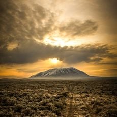
Big Southern Butte
United States of America

Big Southern Butte

38.5 km
United States of America

Fish Creek Dam

27 km
Craters of the Moon National Monument Mission 66 Historic District
United States of America

Craters of the Moon National Monument Mission 66 Historic District

8.5 km
United States of America

Lava Point

29.4 km
Craters of the Moon
United States of America

Craters of the Moon

2.2 km
United States of America

Carey Lake Migratory Bird Management Area

34.7 km
United States of America

Bowl Reservoir

19.4 km
United States of America

Junction Reservoir

15.9 km
United States of America

Bluebird Reservoir

37.9 km
United States of America

Cameron Reservoir

35.5 km
United States of America

Nichols Reservoir

20.3 km
Robert Limbert Visitor Center
United States of America

Robert Limbert Visitor Center

8.5 km
United States of America

White Knob Mountains Wilderness Study Area

37.2 km
United States of America

Appendicitis Hill Wilderness Study Area

34.4 km
United States of America

Fish Creek Reservoir

26.6 km
United States of America

Lava Field

14.6 km
United States of America

Snowdrift Crater

8.4 km
United States of America

Natural Arch

5.3 km
United States of America

Bridge of the Moon

7.9 km
United States of America

Bridge of Tears

6 km
United States of America

Arco Rodeo Grounds

30.4 km
United States of America

Lava Point

29.4 km
United States of America

Scenic Overlook Craters of the Moon

8.6 km
United States of America

Scenic viewpoint

6.6 km
United States of America

Big Sink Overlook

4.9 km
United States of America

Inferno Cone Viewpoint

6.4 km
United States of America

Scenic viewpoint

8.9 km
Show the full map
Reviews
Share your experience

No review yet

Discussions
Start a discussion...

No discussion yet

« Craters of the Moon National Wilderness - Volcanic wilderness area in Snake River Plain, Idaho » is provided by Around Us (aroundus.com). Images and texts are derived from Wikimedia project under a Creative Commons license. You are allowed to copy, distribute, and modify copies of this page, under the conditions set by the license, as long as this note is clearly visible.

Discover hidden gems everywhere you go!

From secret cafés to breathtaking viewpoints, skip the crowded tourist spots and find places that match your style. Our app makes it easy with voice search, smart filtering, route optimization, and insider tips from travelers worldwide. Download now for the complete mobile experience.

Around Us App Screenshot

A unique approach to discovering new places

Le Figaro

All the places worth exploring

France Info

A tailor-made excursion in just a few clicks

20 Minutes

Around Us
Travel Guide & Maps
Download

Send to your phone

QR Code
1

Open the camera app on your mobile.

2

Point at the QR code with your camera. A notification will appear.

3

Tap the notification to open the link.