See the monuments around you in AROpen chests in the app
Around Us is built for your phone — point your camera at the streets and discover the monuments and places around you in augmented reality.Around Us is built for your phone — chests unlock when you walk, explore and capture nearby places.
Algarve in photos: golden beaches, limestone cliffs, and sea caves of southern Portugal
The Algarve offers some of Portugal's most scenic landscapes, with a coastline alternating between golden beaches, ochre limestone cliffs, and rock formations shaped by marine erosion. This collection features the area's most notable sites, from the sea caves of Benagil to the natural arches of Ponta da Piedade, and the expansive areas of Ria Formosa, a protected wetland spanning 37 miles (60 kilometers) along the coast.
Beyond the coastline, the Algarve also boasts a notable historical heritage, including the medieval Silves Castle built from red sandstone and the white alleys of the old town of Albufeira. Beaches such as Praia da Marinha and Praia do Amado attract photographers as well as surfers, while coastal villages like Cacela Velha maintain an authentic ambiance. These locations are particularly suitable for photography due to their contrasting colors and Mediterranean light.
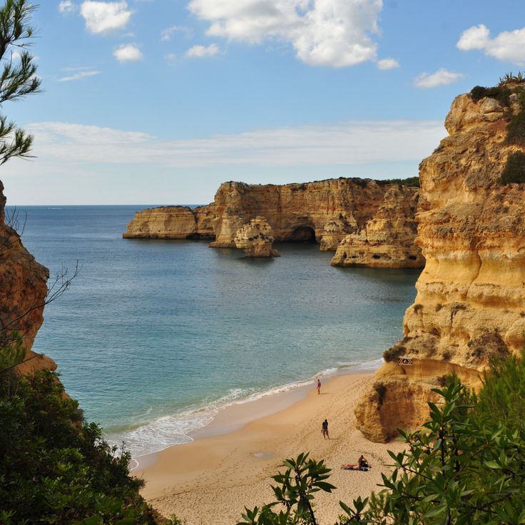
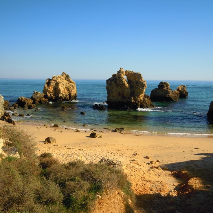
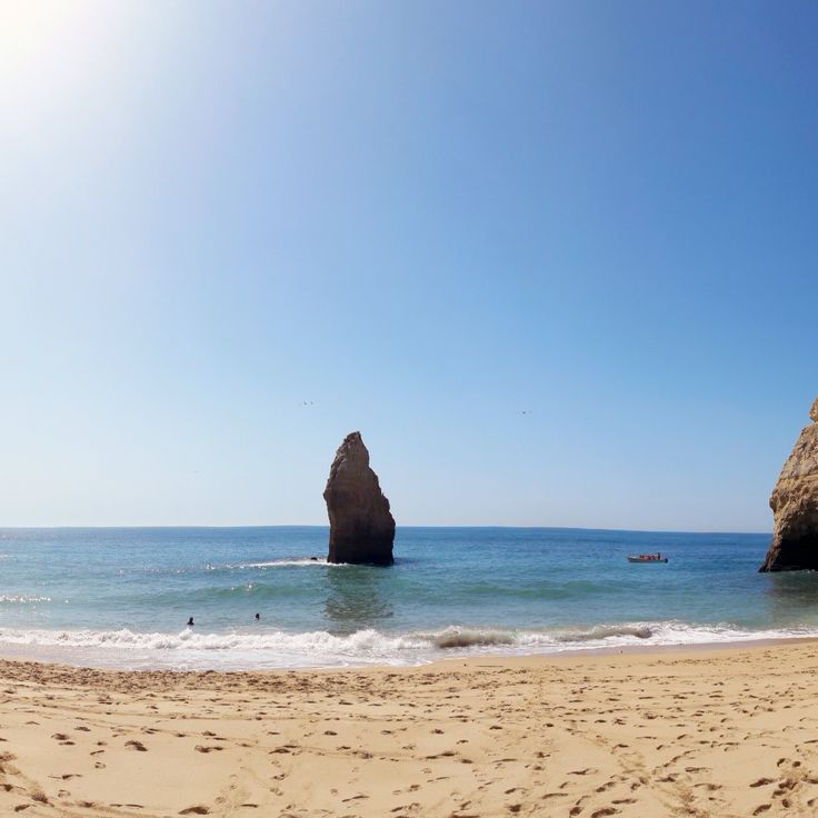
This cove sits between limestone cliffs in the western Algarve and provides access via a stone staircase carved into the rock. The golden sand stretches roughly 560 feet and is bordered by ochre rock formations shaped by marine erosion. At low tide, tidal pools between the offshore rocks can be explored. The cove serves as a photographic example of the geological contrasts along this coastline, with its sequence of sandy beach, vertical cliffs and natural rock arches.
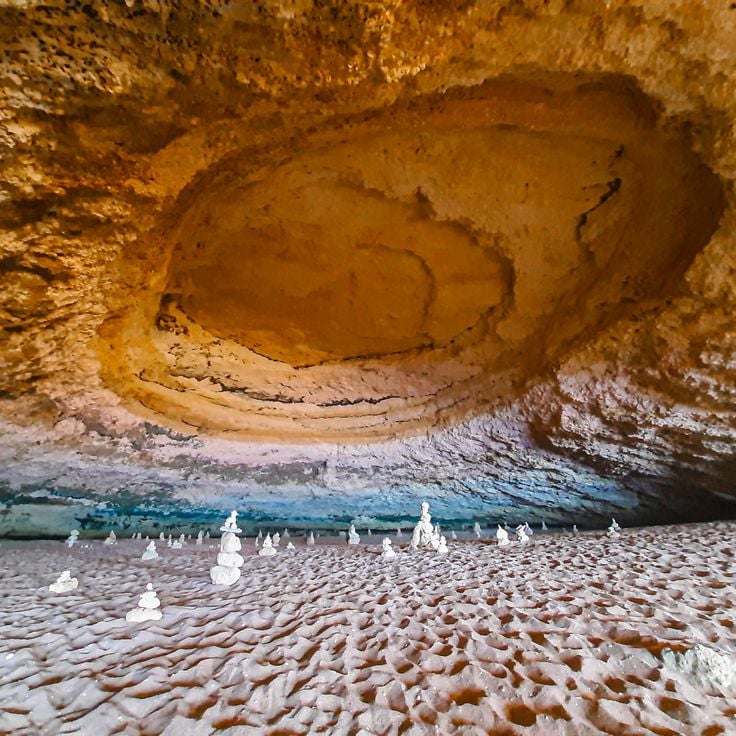
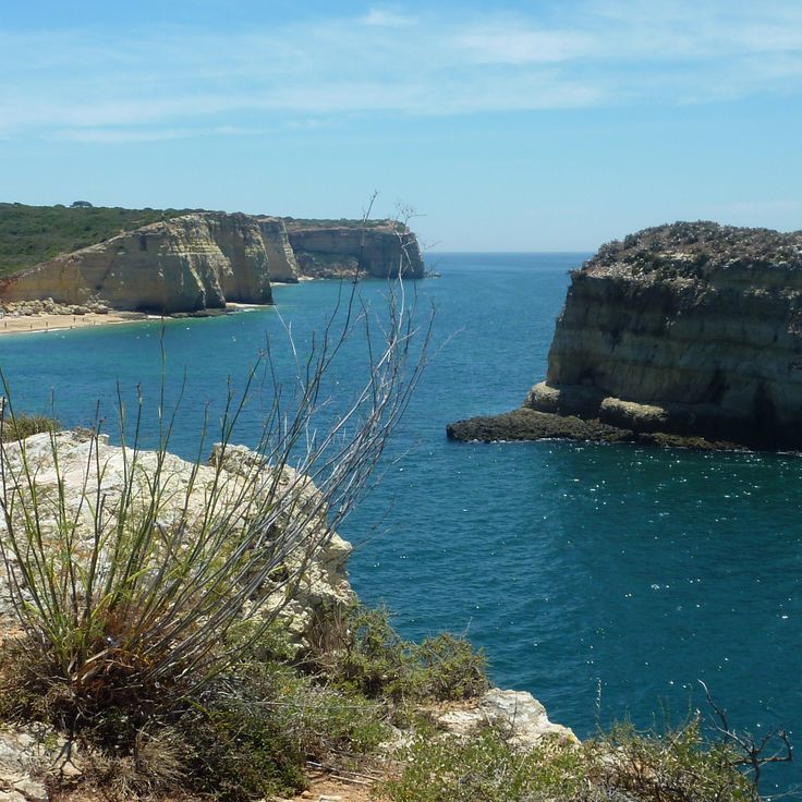
This sea cave near Lagoa ranks among the most photographed coastal formations in the Algarve and can only be reached by boat or by swimming. Wave action has carved a chamber into the limestone cliff over thousands of years, leaving a circular opening in the ceiling that allows sunlight to illuminate the sandy floor inside. The cave sits about 500 feet from shore and can be accessed by kayak, standup paddleboard or guided boat tours departing from Carvoeiro or Armação de Pêra when sea conditions permit.
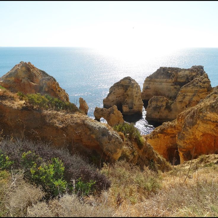
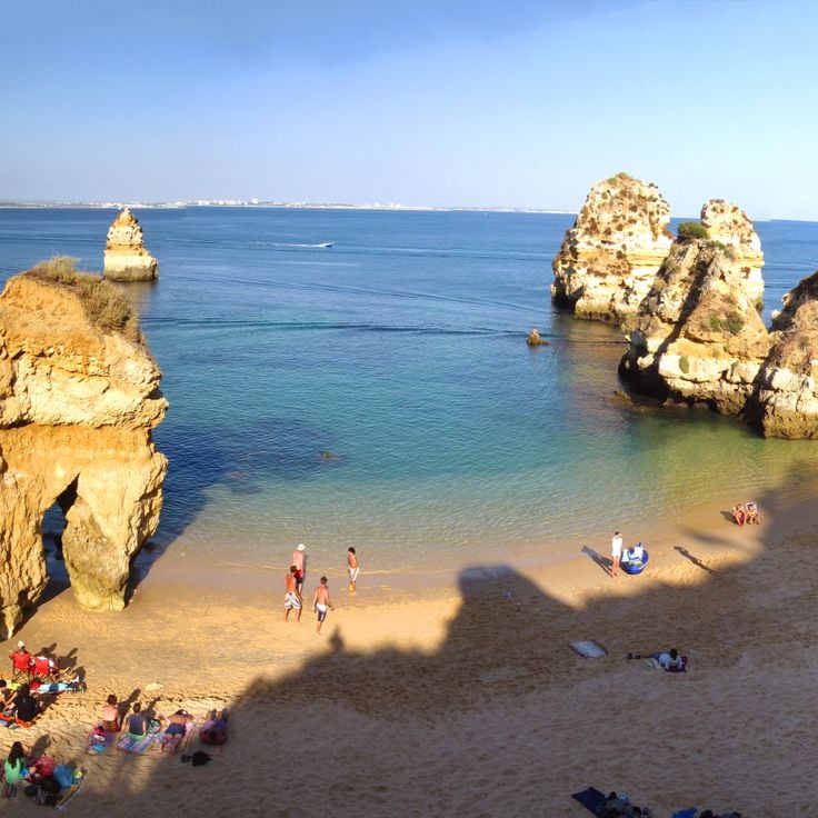
The limestone cliffs of Ponta da Piedade rise about 65 feet (20 meters) above the Atlantic and rank among the most striking geological formations along the Algarve coast. Wind and waves have carved a labyrinth of arches, caves and tunnels into the ochre rock over thousands of years, best explored from the water. Boat tours navigate through narrow passages between the rock pinnacles, while walking trails along the cliff tops offer views across the jagged coastline. The warm light of early morning and late afternoon hours enhances the contrast between the yellow stone and the turquoise water.
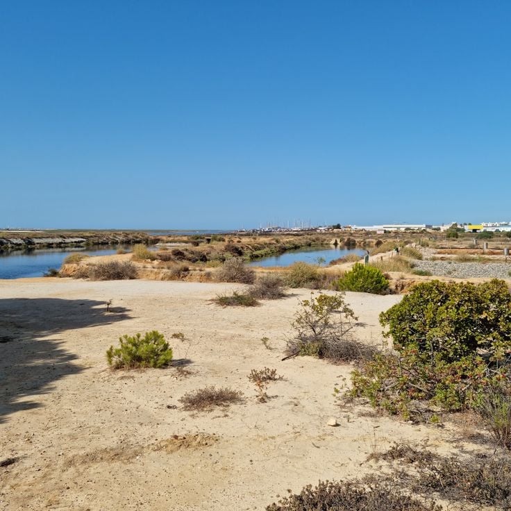
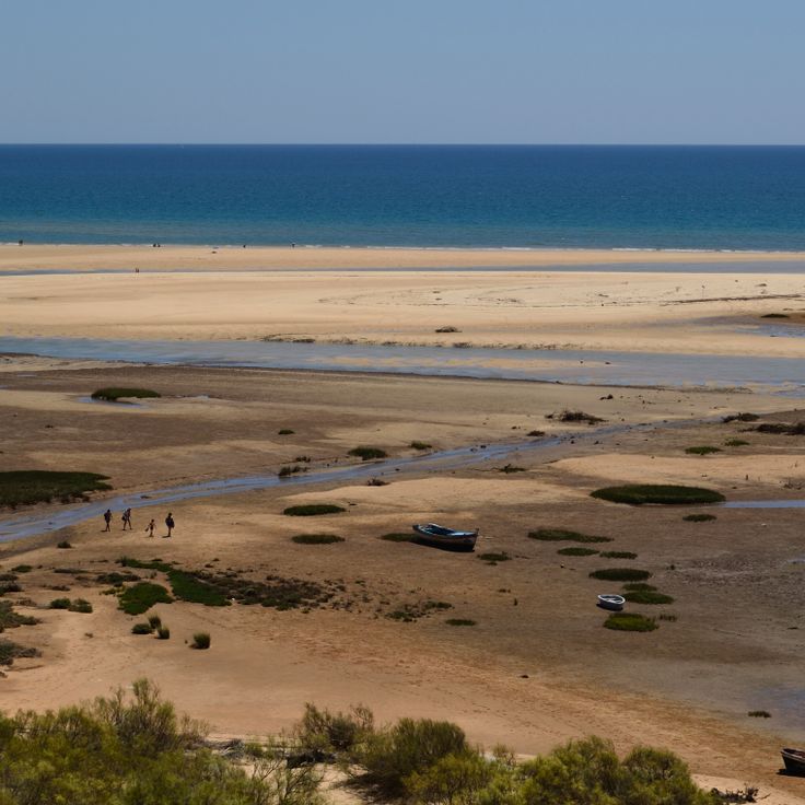
The Ria Formosa stretches roughly 60 kilometers (37 miles) along the coast and ranks among the most important wetland systems in southern Europe. This lagoon complex consists of a chain of barrier islands, sandbars, salt marshes and tidal channels that provide habitat for hundreds of bird species, fish and shellfish. The area serves as a critical stopover for migratory birds and supports permanent populations of flamingos, spoonbills and little egrets. The shallow waters and shifting light conditions during tidal cycles create conditions for landscape photography with reflections and silhouettes. Traditional salt pans and oyster farms have shaped the economic life of the lagoon region for centuries.
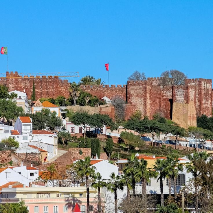
The medieval fortress of red sandstone dominates the town and provides sweeping views over the surrounding landscape. Castello de Silves was built during Moorish rule between the 8th and 13th centuries and remains one of the best preserved castle structures in the Algarve. The massive red walls extend over several thousand square meters and enclose multiple towers, cisterns and a spacious courtyard. Its strategic position on a hill above the Arade River once allowed control of important trade routes into the interior. From the battlements, views stretch across the rooftops of Silves to the surrounding hills and orange groves, securing the castle's place in this photographic collection of the Algarve.
This beach near Albufeira sits between tall limestone cliffs and offers clear water reaching about 6.5 feet (2 meters) in depth near the shore. The golden sand cove is accessible via a coastal path or a steep descent and belongs to the more sheltered sections of the Algarve coastline. The rock formations and natural seclusion make Praia dos Arrifes an interesting subject for photographers seeking to capture the contrasts between sand, cliffs and sea.
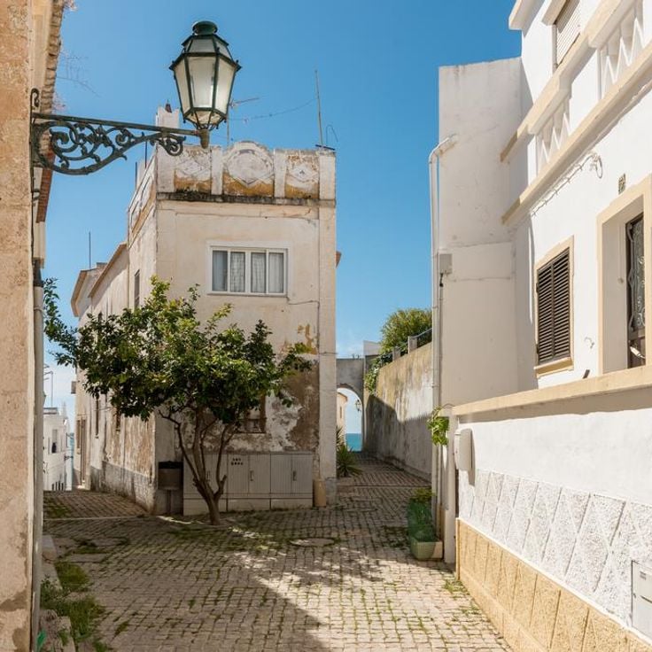
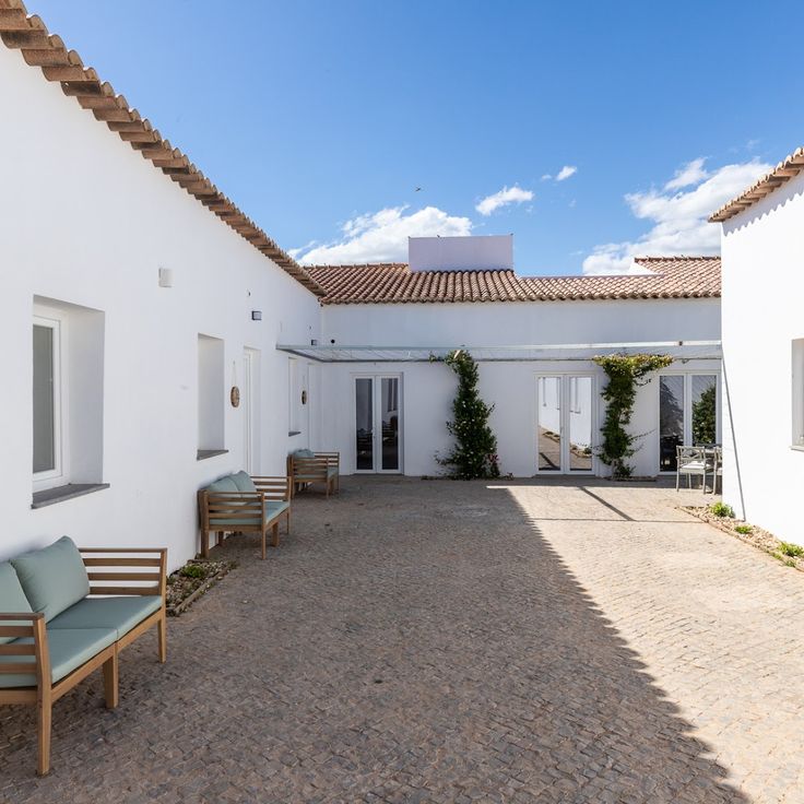
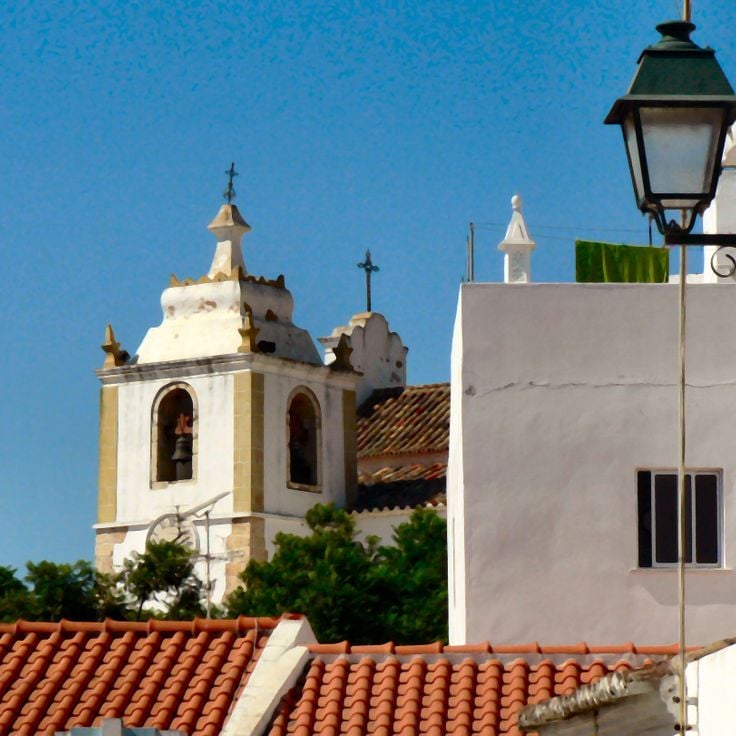
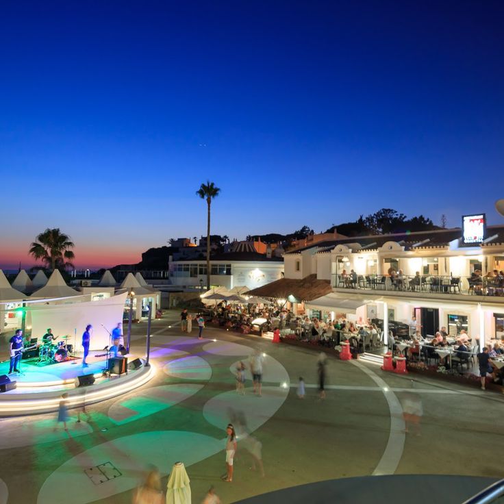
The old town of Albufeira spreads across several narrow streets above the modern waterfront and displays the characteristic architecture of the Algarve with whitewashed houses, wrought-iron balconies and square plazas. This historic quarter was largely rebuilt after the 1755 earthquake and combines traditional Portuguese elements with the tourist infrastructure that has developed since the 1960s. The cobbled streets lead to small squares lined with restaurants and bars that become particularly active after dark, while during daytime the white facades provide clear contrast against the blue sky.
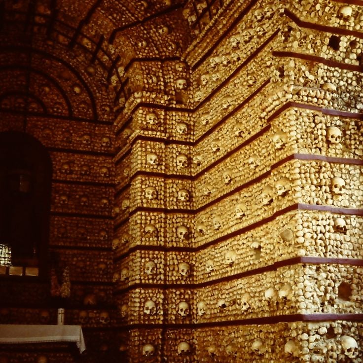
This 16th-century chapel diverges from the Algarve's coastal scenery by its location in the Alentejo region, yet represents another facet of Portuguese architectural heritage. Walls and columns incorporate over five thousand human bones and skulls, arranged by Franciscan monks. The Chapel of Bones serves as a memento mori and offers photographers contrasting textures and patterns within its dim interior.
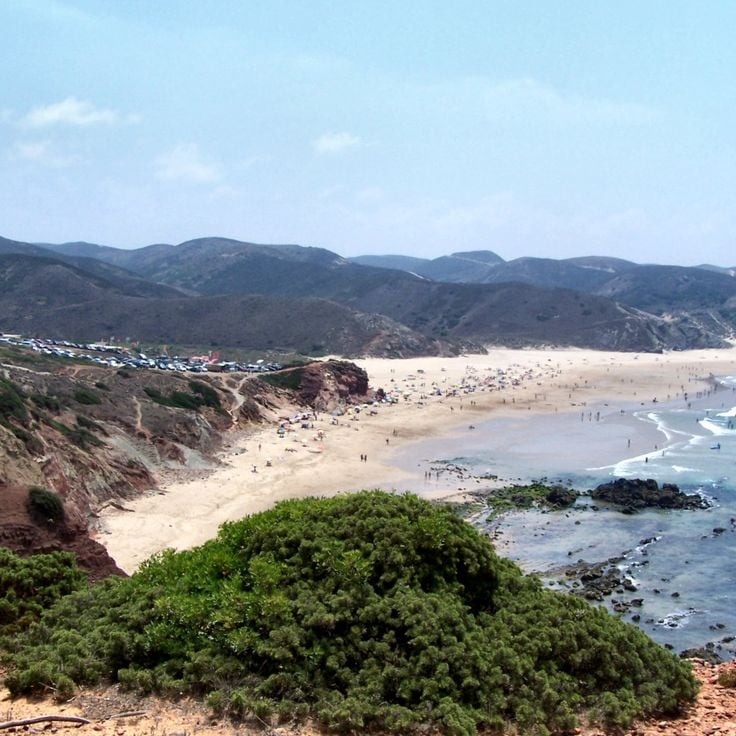
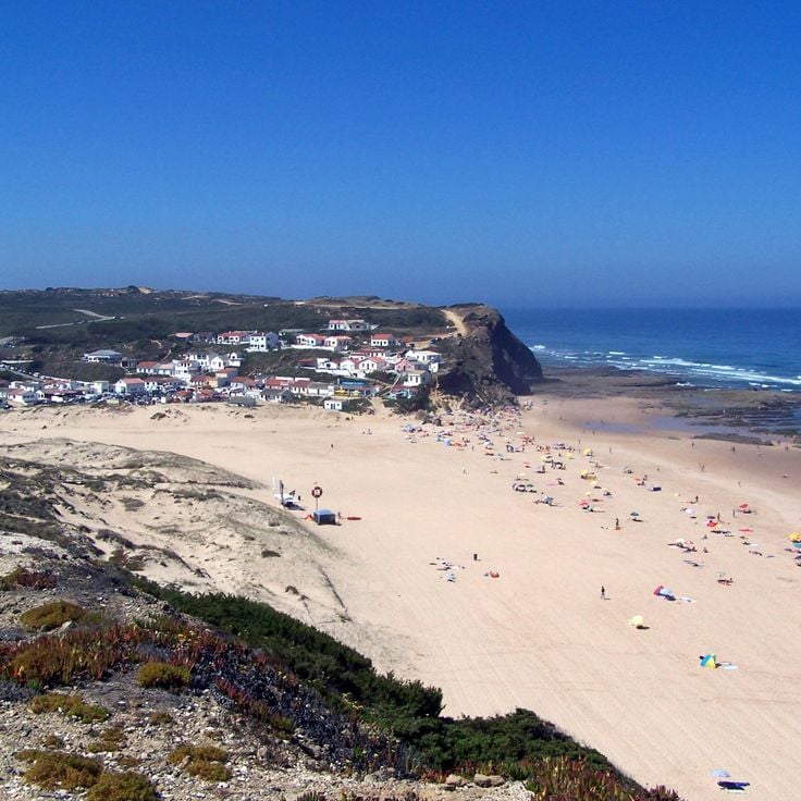
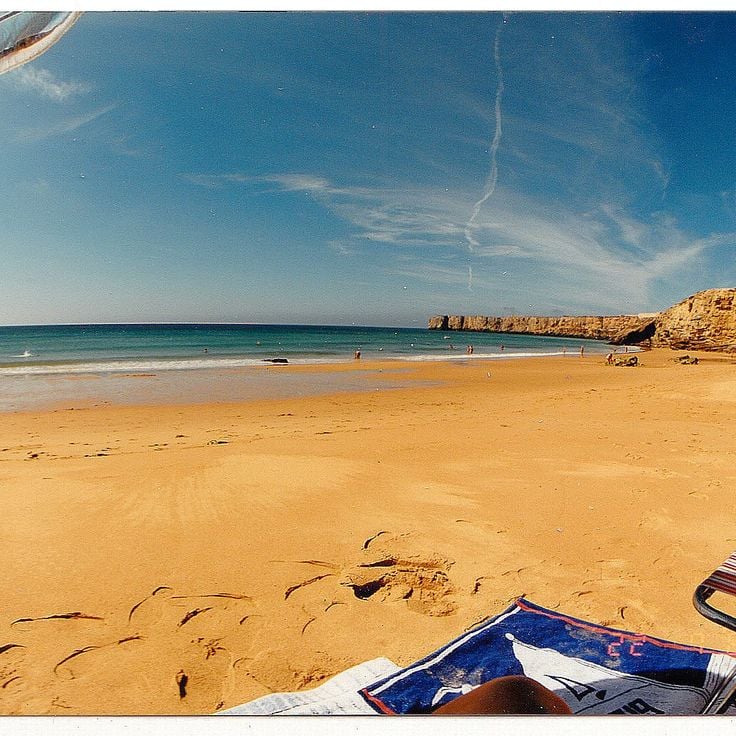
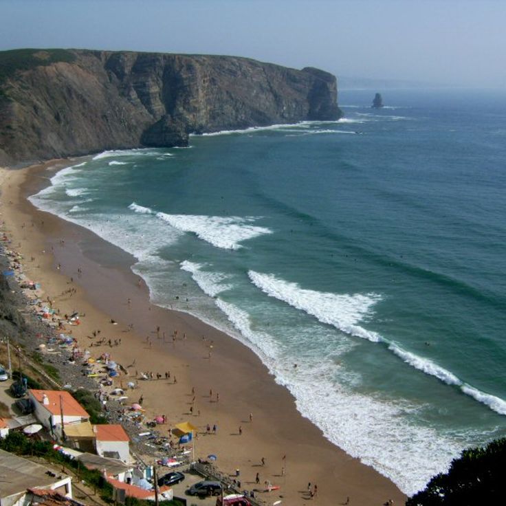
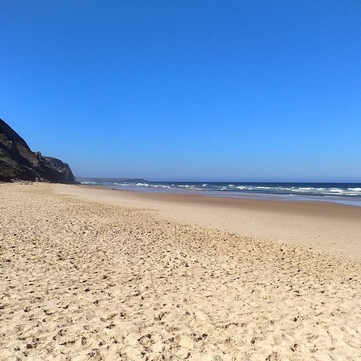
This Atlantic bay on the western Algarve coast is known for its consistent waves and draws surfers from across Europe. The beach stretches roughly 0.6 miles along a sandy shore framed by tall rock formations that provide wind protection and natural viewing points. Praia do Amado sits away from the main tourist centers and maintains a calm character despite its popularity with wave riders, especially outside the summer months.
Praia de Cacela Velha stretches along a protected lagoon at the eastern end of the Ria Formosa, accessible by footbridge or boat from the historic village above. The fine sand runs for several miles parallel to shallow waters that expose extensive sandbanks at low tide, offering photographic compositions with the white church tower in the background. The setting combines the natural dynamics of the tidal zone with the traditional architecture of Cacela Velha, one of the best preserved historic hamlets in the Algarve, distinguishing this area from the more heavily touristed sections of the coast.
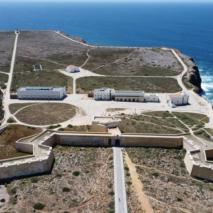
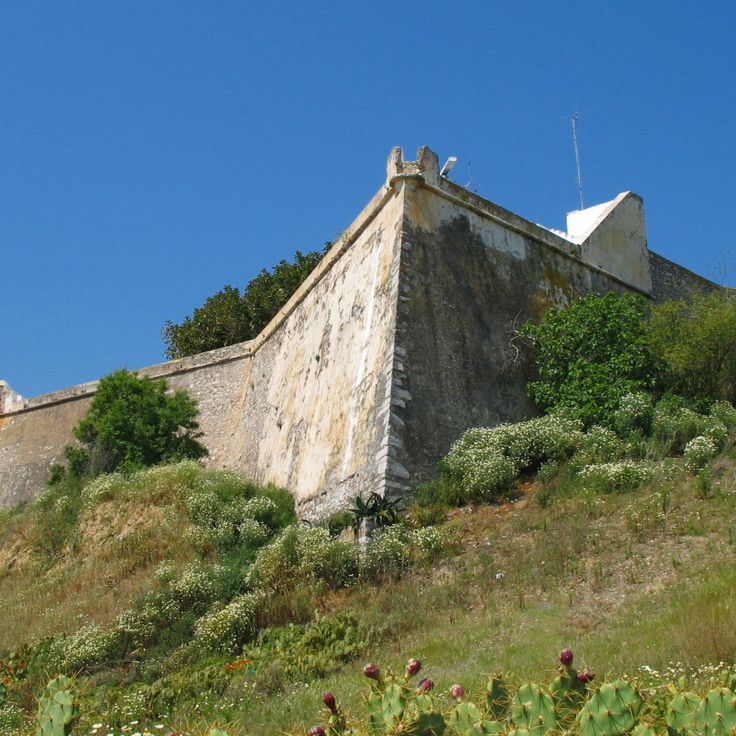
The fortress of Sagres was built in the 15th century during the Portuguese Age of Discovery and sits on a rocky promontory above the Atlantic. From its walls, visitors overlook the cliffs and open ocean that navigators like Henry the Navigator studied while planning expeditions to Africa. The site includes a 16th-century chapel and a 141-foot (43-meter) stone wind rose whose original purpose remains unclear. The fortress documents Portugal's maritime history when Sagres served as a center for nautical research, and offers photographers the combination of historic architecture and the cliffs at Europe's southwestern edge.
Quinta da Rocha sits in the Tavira hinterland and reveals the agricultural side of the Algarve, with olive groves and traditional farmsteads. The area presents a quieter face of the south, away from coastal towns, with open fields and whitewashed homesteads standing out against the green of the olive trees. The landscape works well for capturing rural Portugal, particularly during harvest season or in early morning light when the sun defines the contours of the hills.
Tavira Island stretches eleven kilometers along the coast within the Ria Formosa Natural Park and offers expansive sandy beaches backed by Atlantic waters. Accessible by ferry from Tavira's harbor, the car-free island preserves an undeveloped shoreline with dune vegetation and salt marshes. Praia da Ilha de Tavira forms a continuous sand bar bordered on the landward side by lagoon waters where wading birds and flamingos can be observed. During summer months, a few beach bars provide services, while the eastern sections of the island remain mostly deserted and suitable for long beach walks.
Fonte da Telha stretches several miles southwest of Almada, forming one of the more extensive beach areas near Lisbon. This coastal stretch features golden sand dunes and a sheltered position that makes it popular with both surfers and beachgoers.
This viewpoint rises above the historic center of Faro and offers panoramic views across the city and the Ria Formosa lagoon stretching toward the horizon. The Miradouro de Santa Catarina allows photographers to capture the white rooftops of the old town spreading across several hills, with the blue-green waters of the natural park in the background.
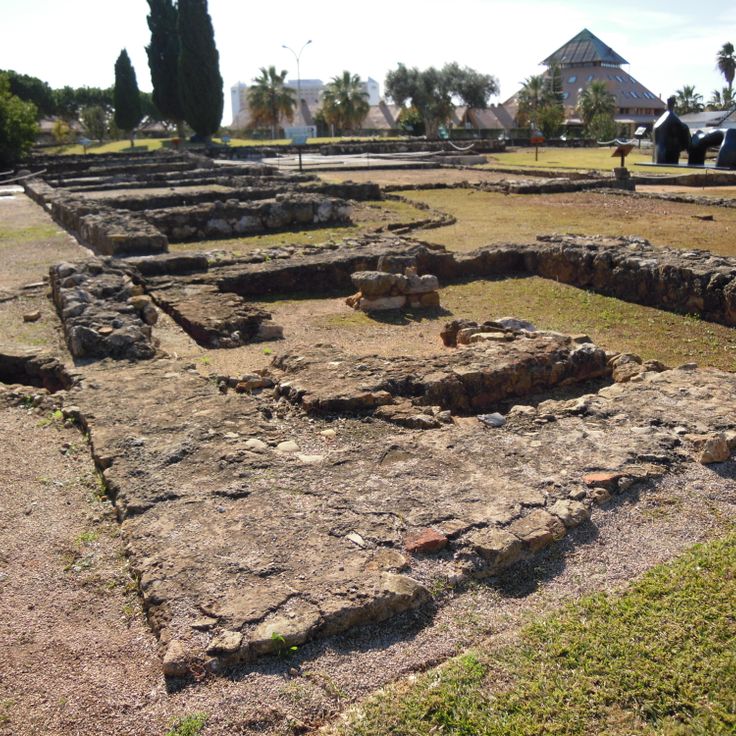
This Roman archaeological site in Vilamoura preserves the remains of a villa occupied from the 1st to the 5th century AD, which once served as a production center for fish sauce and salted fish. The exposed mosaics, thermal baths and foundations document the economic importance of the region during Roman rule along the southern Portuguese coast. The site covers approximately 17,000 square feet (1,600 square meters) and offers direct insight into Roman construction techniques and daily life in a coastal settlement. The complex lies near the modern marina and allows visitors to combine historical exploration with access to contemporary Vilamoura facilities.
This small beach near Carvoeiro is accessible only by a steep staircase carved through a gap in the cliffs, leading to a sheltered cove with clear water surrounded by tall limestone formations. The restricted access has kept Praia do Carvalho less crowded than neighboring beaches, though the dramatic rock formations and turquoise water make it popular with photographers. The beach measures roughly 165 feet (50 meters) in length and offers limited shade, making it best suited for early morning or late afternoon visits when the light enhances the ochre-colored cliffs.
This beach in Lagos combines honey-colored sand with clear water and rugged limestone cliffs that take on warm ocher tones between April and September. Praia do Camilo sits in a sheltered cove accessible via a wooden staircase with around 200 steps. The rock formations create natural arches and caves that can be explored at low tide. The transparent water reaches temperatures around 68°F (20°C) in summer and offers good visibility for snorkeling along the rock walls. The compact size of the beach and its surrounding cliffs create a protected setting that makes it a frequently photographed location on the Algarve coast.
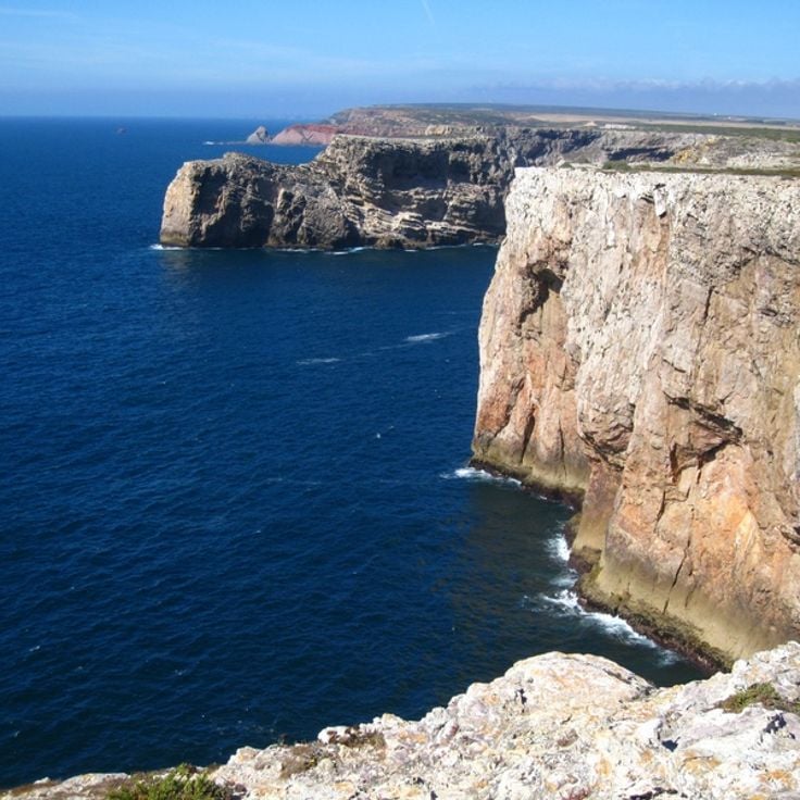
Cabo de São Vicente marks the southwestern tip of mainland Europe, where limestone cliffs rise some 250 feet (75 meters) above the Atlantic Ocean. The 19th-century lighthouse stands on this exposed headland near Sagres, where the coastline turns sharply northward. From the clifftops, views extend across open ocean with no land visible on the horizon. The cape served as a critical navigation point for Portuguese mariners in the 15th century, providing the westernmost reference before Atlantic crossings. Persistent winds and sea spray characterize this location year-round, with vegetation limited to low coastal scrub adapted to the harsh conditions.
The wooden boardwalk of Alvor runs along a protected wetland zone at the Algarve estuary, where fresh water mixes with the Atlantic. The elevated wooden walkway allows observation of migratory and wading birds in their natural habitat without disturbing the sensitive shoreline vegetation. The light wood structures form graphic lines against marshland and blue water, particularly photogenic in low sun. This coastal path connects Alvor beach with the estuary and offers varied perspectives on the Ria de Alvor landscape.
Cacela Velha preserves the appearance of a traditional Portuguese village, with whitewashed houses, narrow lanes and a small 16th-century church. This village sits on a low cliff overlooking the Ria Formosa and offers a quiet alternative to the larger coastal towns of the Algarve. The architecture shows Moorish influences and the local fishing community still uses the protected waters of the lagoon.
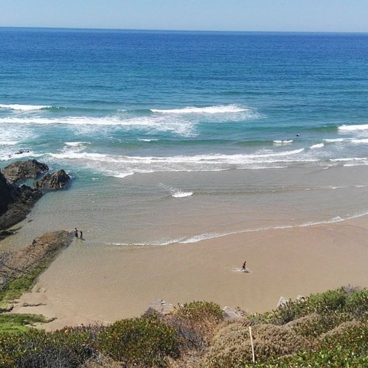
This dune-backed cove sits where the Rio de Seixe meets the Atlantic after a 19-mile inland journey. The river course divides the coarse sand into two sections, while tidal currents reshape the sandbar at the mouth each day. During spring bloom season, wildflowers color the slopes that encircle the beach in a semicircular formation.
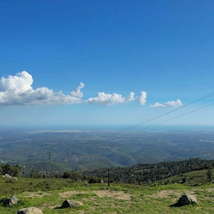
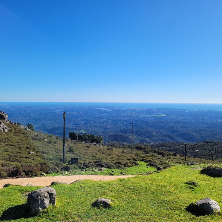
This viewpoint sits at roughly 400 meters (1,300 feet) elevation in the forested hills of the Serra de Monchique, providing wide views over the terraced landscape of the western Algarve. Cerro do Outeiro offers perspectives across cork oak forests, eucalyptus groves and the scattered whitewashed houses of surrounding villages, extending toward the coastline. The position makes this location suitable for landscape photography of the Algarve's inland hills, particularly during morning hours when light defines the valley contours.
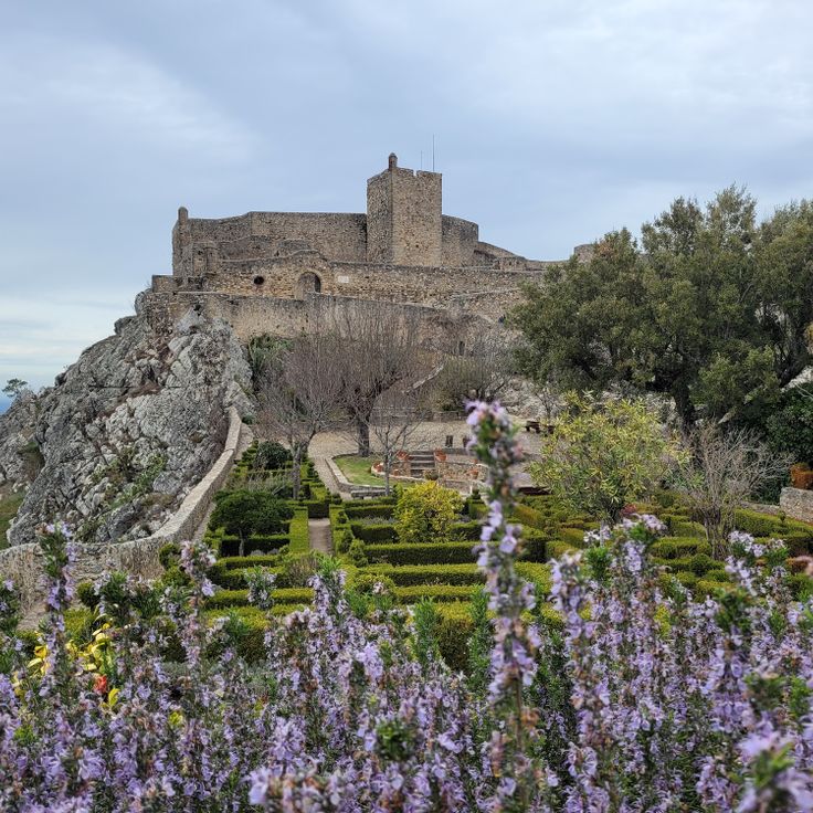
The medieval village of Marvão sits atop an 860-foot (260-meter) granite ridge near the Spanish border, roughly 125 miles (200 kilometers) north of the Algarve. Its 13th-century fortified walls remain intact, enclosing whitewashed houses with slate roofs and narrow cobblestone lanes. From the ramparts, views extend across the Alentejo plains into Spanish Extremadura. The castle houses a museum covering regional history, while the Roman ruins of Ammaia three miles (five kilometers) south document ancient settlement patterns.
This secluded cove west of Aljezur sits between tall schist cliffs and requires a steep descent of roughly 1,000 feet (300 meters). The dark sand and prominent rock formations create strong contrasts with the Atlantic surf, which tends to be forceful here. At low tide, rock pools and smooth schist slabs appear, polished by the waves. The cove is part of the protected coastline within Southwest Alentejo Natural Park, where vegetation consists of low shrubs and endemic plants. The beach suits photographers during late afternoon hours, when the light warms the cliffs.
Vale do Lobo fits into this collection with its ochre cliffs and sandy beaches stretching several miles, typical of the central Algarve coast. The rock formations shaped by wind and waves form natural arches and jutting structures, while the wide beach reveals large expanses of golden sand at low tide. Late afternoon light enhances the warm tones of the limestone and creates clear contrasts between cliff, sand and Atlantic. As a developed coastal area with several access points, Vale do Lobo offers various perspectives on characteristic Algarve landscapes.
Figueira Beach occupies a cove where the Seixe River meets the Atlantic, creating a natural divide between the northern and southern sections of the shore. The surrounding cliffs display layered sedimentary rock in tones of ochre and gray, characteristic of this western Algarve coastline. The river mouth provides calmer waters compared to the open ocean, which brings regular surf. Vegetation covers the hillsides above the beach, and walking trails follow the clifftops, offering views of the coastal formations and the meeting point of river and sea.
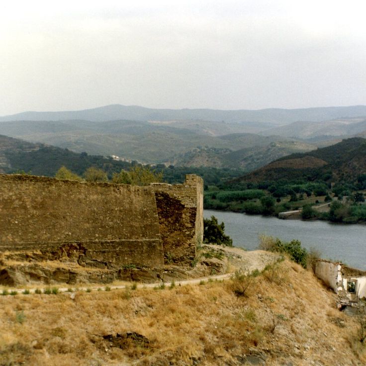
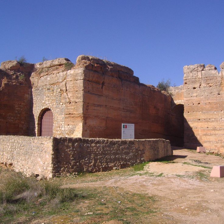
The ruins of Castelo de Paderne stand on a hillside in the Algarve interior and represent one of the few remaining Islamic fortifications in Portugal. Built from reddish taipa clay in the 12th century, this castle overlooks the agricultural landscape between Albufeira and Loulé. From its walls, views extend across olive groves and fields toward the distant coastline, illustrating the strategic importance of this location.
This beach stretches along a sheltered bay west of Sagres, offering shallow waters and fine-grained sand. Praia do Martinhal sits away from the prevailing Atlantic currents and works well for families with children. The nearby resort integrates into the natural dune landscape, while several walking trails provide access to the coastline. The beach connects the rougher Atlantic shore with the calmer waters of the southern Algarve, demonstrating the geological variety of this region.
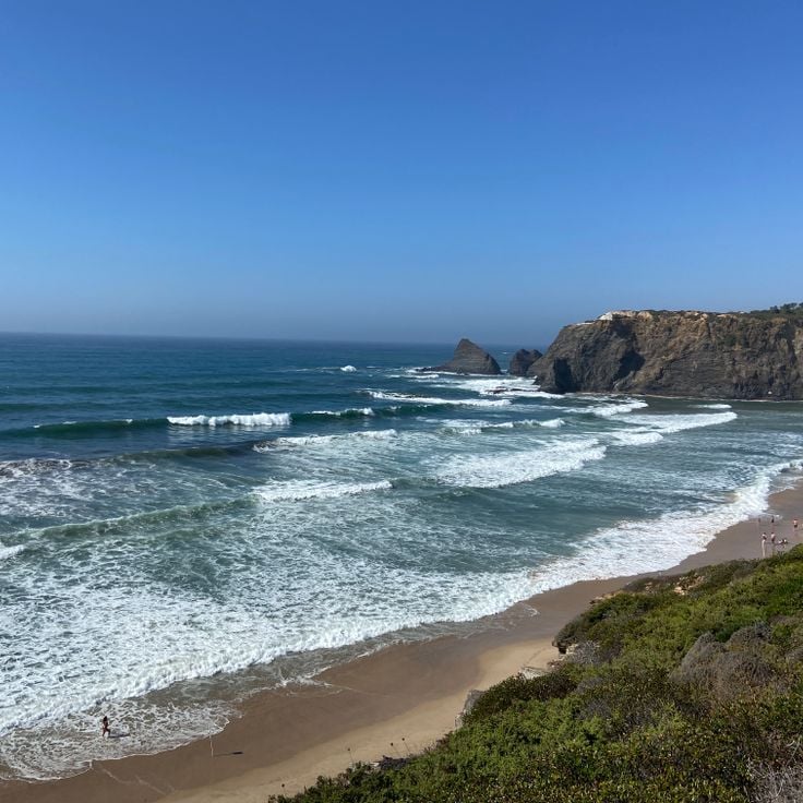
This beach on the southwestern Algarve sits between high cliffs and attracts surfers who find consistent waves and few crowds. The bay opens toward the Atlantic and offers wide coastal views from the surrounding cliffs. The sand is dark and coarse, the setting largely undeveloped with sparse construction in the adjacent village. Arrifana lies along the Costa Vicentina, a protected stretch of coastline with limited tourism infrastructure. At low tide, rocks appear at the base of the cliffs, reflecting light particularly well in late afternoon.
This 18th-century fortress rises above the coastal landscape of Cacela Velha, offering expansive views across the sandbanks of Ria Formosa and the surrounding fields. The fortified complex includes defensive walls and a watchtower, their ochre stone contrasting with the white plaster of adjacent houses. From the ramparts, the view extends over the lagoon system toward the Atlantic, with shallow waters and sandbars displaying different hues depending on light conditions. The fortress stands at the edge of the historic village center, where a small church and traditional dwellings cluster together.
Praia de Vale Figueiras sits along an undeveloped stretch of coastline north of Aljezur, offering a mile-long sandy beach framed by steep schist cliffs. Its location on the Vicentine Coast section protects the cove from larger tourism developments, making it a preferred destination for photographers capturing the contrast between dark rock faces and pale sand. Access requires an unpaved road and a steep 15-minute descent, which keeps the beach relatively quiet even during peak season.
The Monchique mountains offer a contrast to the Algarve coastline, presenting a forested mountain landscape with eucalyptus groves, cork oaks and Mediterranean vegetation rising to over 2,950 feet (900 meters) above sea level. This range forms the highest elevation in the region and provides views of both the Atlantic coast and the interior on clear days. Hiking trails lead through terraced slopes and past abandoned villages, while the thermal springs at Caldas de Monchique have been in use since Roman times.
This beach at the mouth of the Odeceixe River marks the natural boundary between the Algarve and the Alentejo and provides a photographic subject that combines fishing boats with the colored horizons of the region. Traditional vessels rest along the shore as the river meets the ocean, forming a sheltered cove. The backdrop extends from the cliffs to the sandbars that shift with the tides. Light varies considerably throughout the day, emphasizing the silhouettes of the boats and strengthening the contrast with the surrounding landscape.
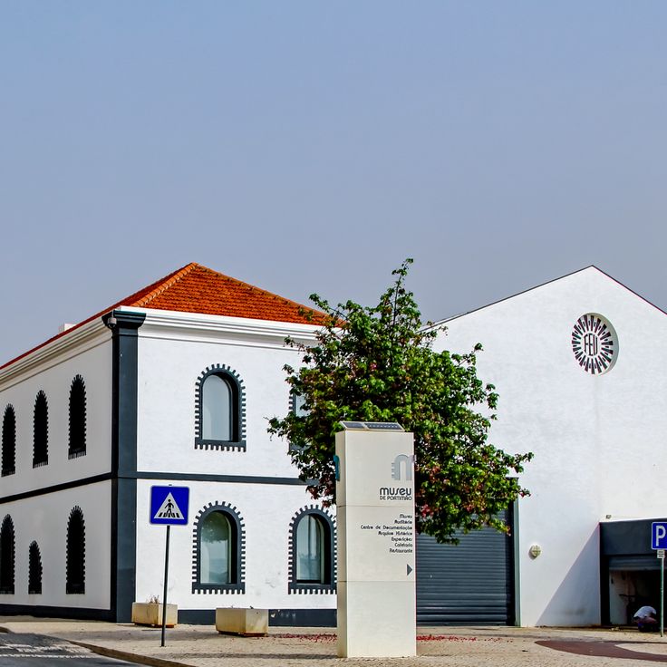
The Portimão Museum occupies a former fish canning factory from the 19th century and documents the city's industrial past and maritime tradition. The exhibits show the sardine processing operation, with preserved machinery and tools that remained in use until the 1970s. Additional collections cover the region's archaeology, from Roman finds to the Moorish period. The building itself is part of the exhibition, with its high ceilings and industrial architecture illustrating the character of a 20th-century port city.
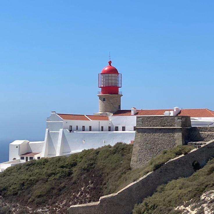
The lighthouse at Cabo de São Vicente marks the southwesternmost point of mainland Europe on a cliff approximately 250 feet (75 meters) above the Atlantic Ocean. The structure consists of a white tower with red stripes and houses one of the most powerful beacons in Europe, with a range of about 37 miles (60 kilometers). The exposed location attracts photographers for its raw coastal scenery and lighting conditions, particularly in late afternoon when the sun illuminates the limestone cliffs of the Costa Vicentina.
Praia dos Caneiros sits sheltered between low ochre cliffs at the western edge of Ferragudo. This sand beach stretches about 650 feet (200 meters) and offers views across to the coastal village opposite the Arade estuary. Rock formations on both sides of the beach create natural composition for wide-angle shots, particularly at low tide when wet sand mirrors the cliffs. Several rock outcrops in the water provide foreground interest for landscape photography. The exposed location ensures consistent light during morning hours when the sun illuminates the rock faces directly.
The castle of Alcoutim rises above the Guadiana River at the Spanish border, documenting the strategic importance of this river fortress since Moorish times. This medieval structure was expanded in the 14th century under King Denis I and played a central role in border defense conflicts between Portugal and Castile. From the ramparts, views extend across the river to the Spanish town of Sanlúcar de Guadiana on the opposite bank. The fortification architecture, with its preserved towers and wall sections, demonstrates the military construction methods of this period and offers photographers clear compositions of stone, river and sky in the characteristic light of the Alentejo-Algarve border region.
This cove sits between limestone cliffs in the western Algarve and provides access via a stone staircase carved into the rock. The golden sand stretches roughly 560 feet and is bordered by ochre rock formations shaped by marine erosion. At low tide, tidal pools between the offshore rocks can be explored. The cove serves as a photographic example of the geological contrasts along this coastline, with its sequence of sandy beach, vertical cliffs and natural rock arches.
This sea cave near Lagoa ranks among the most photographed coastal formations in the Algarve and can only be reached by boat or by swimming. Wave action has carved a chamber into the limestone cliff over thousands of years, leaving a circular opening in the ceiling that allows sunlight to illuminate the sandy floor inside. The cave sits about 500 feet from shore and can be accessed by kayak, standup paddleboard or guided boat tours departing from Carvoeiro or Armação de Pêra when sea conditions permit.
The limestone cliffs of Ponta da Piedade rise about 65 feet (20 meters) above the Atlantic and rank among the most striking geological formations along the Algarve coast. Wind and waves have carved a labyrinth of arches, caves and tunnels into the ochre rock over thousands of years, best explored from the water. Boat tours navigate through narrow passages between the rock pinnacles, while walking trails along the cliff tops offer views across the jagged coastline. The warm light of early morning and late afternoon hours enhances the contrast between the yellow stone and the turquoise water.
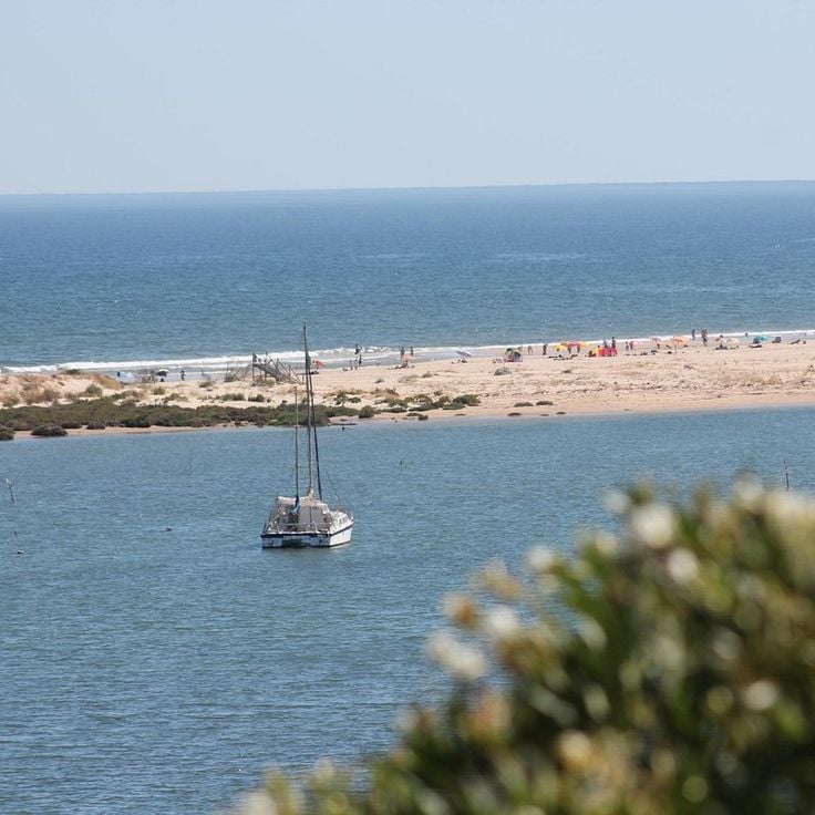
The Ria Formosa stretches roughly 60 kilometers (37 miles) along the coast and ranks among the most important wetland systems in southern Europe. This lagoon complex consists of a chain of barrier islands, sandbars, salt marshes and tidal channels that provide habitat for hundreds of bird species, fish and shellfish. The area serves as a critical stopover for migratory birds and supports permanent populations of flamingos, spoonbills and little egrets. The shallow waters and shifting light conditions during tidal cycles create conditions for landscape photography with reflections and silhouettes. Traditional salt pans and oyster farms have shaped the economic life of the lagoon region for centuries.
The medieval fortress of red sandstone dominates the town and provides sweeping views over the surrounding landscape. Castello de Silves was built during Moorish rule between the 8th and 13th centuries and remains one of the best preserved castle structures in the Algarve. The massive red walls extend over several thousand square meters and enclose multiple towers, cisterns and a spacious courtyard. Its strategic position on a hill above the Arade River once allowed control of important trade routes into the interior. From the battlements, views stretch across the rooftops of Silves to the surrounding hills and orange groves, securing the castle's place in this photographic collection of the Algarve.
This beach near Albufeira sits between tall limestone cliffs and offers clear water reaching about 6.5 feet (2 meters) in depth near the shore. The golden sand cove is accessible via a coastal path or a steep descent and belongs to the more sheltered sections of the Algarve coastline. The rock formations and natural seclusion make Praia dos Arrifes an interesting subject for photographers seeking to capture the contrasts between sand, cliffs and sea.
The old town of Albufeira spreads across several narrow streets above the modern waterfront and displays the characteristic architecture of the Algarve with whitewashed houses, wrought-iron balconies and square plazas. This historic quarter was largely rebuilt after the 1755 earthquake and combines traditional Portuguese elements with the tourist infrastructure that has developed since the 1960s. The cobbled streets lead to small squares lined with restaurants and bars that become particularly active after dark, while during daytime the white facades provide clear contrast against the blue sky.
This 16th-century chapel diverges from the Algarve's coastal scenery by its location in the Alentejo region, yet represents another facet of Portuguese architectural heritage. Walls and columns incorporate over five thousand human bones and skulls, arranged by Franciscan monks. The Chapel of Bones serves as a memento mori and offers photographers contrasting textures and patterns within its dim interior.
This Atlantic bay on the western Algarve coast is known for its consistent waves and draws surfers from across Europe. The beach stretches roughly 0.6 miles along a sandy shore framed by tall rock formations that provide wind protection and natural viewing points. Praia do Amado sits away from the main tourist centers and maintains a calm character despite its popularity with wave riders, especially outside the summer months.
Praia de Cacela Velha stretches along a protected lagoon at the eastern end of the Ria Formosa, accessible by footbridge or boat from the historic village above. The fine sand runs for several miles parallel to shallow waters that expose extensive sandbanks at low tide, offering photographic compositions with the white church tower in the background. The setting combines the natural dynamics of the tidal zone with the traditional architecture of Cacela Velha, one of the best preserved historic hamlets in the Algarve, distinguishing this area from the more heavily touristed sections of the coast.
The fortress of Sagres was built in the 15th century during the Portuguese Age of Discovery and sits on a rocky promontory above the Atlantic. From its walls, visitors overlook the cliffs and open ocean that navigators like Henry the Navigator studied while planning expeditions to Africa. The site includes a 16th-century chapel and a 141-foot (43-meter) stone wind rose whose original purpose remains unclear. The fortress documents Portugal's maritime history when Sagres served as a center for nautical research, and offers photographers the combination of historic architecture and the cliffs at Europe's southwestern edge.
Quinta da Rocha sits in the Tavira hinterland and reveals the agricultural side of the Algarve, with olive groves and traditional farmsteads. The area presents a quieter face of the south, away from coastal towns, with open fields and whitewashed homesteads standing out against the green of the olive trees. The landscape works well for capturing rural Portugal, particularly during harvest season or in early morning light when the sun defines the contours of the hills.
Tavira Island stretches eleven kilometers along the coast within the Ria Formosa Natural Park and offers expansive sandy beaches backed by Atlantic waters. Accessible by ferry from Tavira's harbor, the car-free island preserves an undeveloped shoreline with dune vegetation and salt marshes. Praia da Ilha de Tavira forms a continuous sand bar bordered on the landward side by lagoon waters where wading birds and flamingos can be observed. During summer months, a few beach bars provide services, while the eastern sections of the island remain mostly deserted and suitable for long beach walks.
Fonte da Telha stretches several miles southwest of Almada, forming one of the more extensive beach areas near Lisbon. This coastal stretch features golden sand dunes and a sheltered position that makes it popular with both surfers and beachgoers.
This viewpoint rises above the historic center of Faro and offers panoramic views across the city and the Ria Formosa lagoon stretching toward the horizon. The Miradouro de Santa Catarina allows photographers to capture the white rooftops of the old town spreading across several hills, with the blue-green waters of the natural park in the background.
This Roman archaeological site in Vilamoura preserves the remains of a villa occupied from the 1st to the 5th century AD, which once served as a production center for fish sauce and salted fish. The exposed mosaics, thermal baths and foundations document the economic importance of the region during Roman rule along the southern Portuguese coast. The site covers approximately 17,000 square feet (1,600 square meters) and offers direct insight into Roman construction techniques and daily life in a coastal settlement. The complex lies near the modern marina and allows visitors to combine historical exploration with access to contemporary Vilamoura facilities.
This small beach near Carvoeiro is accessible only by a steep staircase carved through a gap in the cliffs, leading to a sheltered cove with clear water surrounded by tall limestone formations. The restricted access has kept Praia do Carvalho less crowded than neighboring beaches, though the dramatic rock formations and turquoise water make it popular with photographers. The beach measures roughly 165 feet (50 meters) in length and offers limited shade, making it best suited for early morning or late afternoon visits when the light enhances the ochre-colored cliffs.
This beach in Lagos combines honey-colored sand with clear water and rugged limestone cliffs that take on warm ocher tones between April and September. Praia do Camilo sits in a sheltered cove accessible via a wooden staircase with around 200 steps. The rock formations create natural arches and caves that can be explored at low tide. The transparent water reaches temperatures around 68°F (20°C) in summer and offers good visibility for snorkeling along the rock walls. The compact size of the beach and its surrounding cliffs create a protected setting that makes it a frequently photographed location on the Algarve coast.
Cabo de São Vicente marks the southwestern tip of mainland Europe, where limestone cliffs rise some 250 feet (75 meters) above the Atlantic Ocean. The 19th-century lighthouse stands on this exposed headland near Sagres, where the coastline turns sharply northward. From the clifftops, views extend across open ocean with no land visible on the horizon. The cape served as a critical navigation point for Portuguese mariners in the 15th century, providing the westernmost reference before Atlantic crossings. Persistent winds and sea spray characterize this location year-round, with vegetation limited to low coastal scrub adapted to the harsh conditions.
The wooden boardwalk of Alvor runs along a protected wetland zone at the Algarve estuary, where fresh water mixes with the Atlantic. The elevated wooden walkway allows observation of migratory and wading birds in their natural habitat without disturbing the sensitive shoreline vegetation. The light wood structures form graphic lines against marshland and blue water, particularly photogenic in low sun. This coastal path connects Alvor beach with the estuary and offers varied perspectives on the Ria de Alvor landscape.
Cacela Velha preserves the appearance of a traditional Portuguese village, with whitewashed houses, narrow lanes and a small 16th-century church. This village sits on a low cliff overlooking the Ria Formosa and offers a quiet alternative to the larger coastal towns of the Algarve. The architecture shows Moorish influences and the local fishing community still uses the protected waters of the lagoon.
This dune-backed cove sits where the Rio de Seixe meets the Atlantic after a 19-mile inland journey. The river course divides the coarse sand into two sections, while tidal currents reshape the sandbar at the mouth each day. During spring bloom season, wildflowers color the slopes that encircle the beach in a semicircular formation.
This viewpoint sits at roughly 400 meters (1,300 feet) elevation in the forested hills of the Serra de Monchique, providing wide views over the terraced landscape of the western Algarve. Cerro do Outeiro offers perspectives across cork oak forests, eucalyptus groves and the scattered whitewashed houses of surrounding villages, extending toward the coastline. The position makes this location suitable for landscape photography of the Algarve's inland hills, particularly during morning hours when light defines the valley contours.
The medieval village of Marvão sits atop an 860-foot (260-meter) granite ridge near the Spanish border, roughly 125 miles (200 kilometers) north of the Algarve. Its 13th-century fortified walls remain intact, enclosing whitewashed houses with slate roofs and narrow cobblestone lanes. From the ramparts, views extend across the Alentejo plains into Spanish Extremadura. The castle houses a museum covering regional history, while the Roman ruins of Ammaia three miles (five kilometers) south document ancient settlement patterns.
This secluded cove west of Aljezur sits between tall schist cliffs and requires a steep descent of roughly 1,000 feet (300 meters). The dark sand and prominent rock formations create strong contrasts with the Atlantic surf, which tends to be forceful here. At low tide, rock pools and smooth schist slabs appear, polished by the waves. The cove is part of the protected coastline within Southwest Alentejo Natural Park, where vegetation consists of low shrubs and endemic plants. The beach suits photographers during late afternoon hours, when the light warms the cliffs.
Vale do Lobo fits into this collection with its ochre cliffs and sandy beaches stretching several miles, typical of the central Algarve coast. The rock formations shaped by wind and waves form natural arches and jutting structures, while the wide beach reveals large expanses of golden sand at low tide. Late afternoon light enhances the warm tones of the limestone and creates clear contrasts between cliff, sand and Atlantic. As a developed coastal area with several access points, Vale do Lobo offers various perspectives on characteristic Algarve landscapes.
Figueira Beach occupies a cove where the Seixe River meets the Atlantic, creating a natural divide between the northern and southern sections of the shore. The surrounding cliffs display layered sedimentary rock in tones of ochre and gray, characteristic of this western Algarve coastline. The river mouth provides calmer waters compared to the open ocean, which brings regular surf. Vegetation covers the hillsides above the beach, and walking trails follow the clifftops, offering views of the coastal formations and the meeting point of river and sea.
The ruins of Castelo de Paderne stand on a hillside in the Algarve interior and represent one of the few remaining Islamic fortifications in Portugal. Built from reddish taipa clay in the 12th century, this castle overlooks the agricultural landscape between Albufeira and Loulé. From its walls, views extend across olive groves and fields toward the distant coastline, illustrating the strategic importance of this location.
This beach stretches along a sheltered bay west of Sagres, offering shallow waters and fine-grained sand. Praia do Martinhal sits away from the prevailing Atlantic currents and works well for families with children. The nearby resort integrates into the natural dune landscape, while several walking trails provide access to the coastline. The beach connects the rougher Atlantic shore with the calmer waters of the southern Algarve, demonstrating the geological variety of this region.
This beach on the southwestern Algarve sits between high cliffs and attracts surfers who find consistent waves and few crowds. The bay opens toward the Atlantic and offers wide coastal views from the surrounding cliffs. The sand is dark and coarse, the setting largely undeveloped with sparse construction in the adjacent village. Arrifana lies along the Costa Vicentina, a protected stretch of coastline with limited tourism infrastructure. At low tide, rocks appear at the base of the cliffs, reflecting light particularly well in late afternoon.
This 18th-century fortress rises above the coastal landscape of Cacela Velha, offering expansive views across the sandbanks of Ria Formosa and the surrounding fields. The fortified complex includes defensive walls and a watchtower, their ochre stone contrasting with the white plaster of adjacent houses. From the ramparts, the view extends over the lagoon system toward the Atlantic, with shallow waters and sandbars displaying different hues depending on light conditions. The fortress stands at the edge of the historic village center, where a small church and traditional dwellings cluster together.
Praia de Vale Figueiras sits along an undeveloped stretch of coastline north of Aljezur, offering a mile-long sandy beach framed by steep schist cliffs. Its location on the Vicentine Coast section protects the cove from larger tourism developments, making it a preferred destination for photographers capturing the contrast between dark rock faces and pale sand. Access requires an unpaved road and a steep 15-minute descent, which keeps the beach relatively quiet even during peak season.
The Monchique mountains offer a contrast to the Algarve coastline, presenting a forested mountain landscape with eucalyptus groves, cork oaks and Mediterranean vegetation rising to over 2,950 feet (900 meters) above sea level. This range forms the highest elevation in the region and provides views of both the Atlantic coast and the interior on clear days. Hiking trails lead through terraced slopes and past abandoned villages, while the thermal springs at Caldas de Monchique have been in use since Roman times.
This beach at the mouth of the Odeceixe River marks the natural boundary between the Algarve and the Alentejo and provides a photographic subject that combines fishing boats with the colored horizons of the region. Traditional vessels rest along the shore as the river meets the ocean, forming a sheltered cove. The backdrop extends from the cliffs to the sandbars that shift with the tides. Light varies considerably throughout the day, emphasizing the silhouettes of the boats and strengthening the contrast with the surrounding landscape.
The Portimão Museum occupies a former fish canning factory from the 19th century and documents the city's industrial past and maritime tradition. The exhibits show the sardine processing operation, with preserved machinery and tools that remained in use until the 1970s. Additional collections cover the region's archaeology, from Roman finds to the Moorish period. The building itself is part of the exhibition, with its high ceilings and industrial architecture illustrating the character of a 20th-century port city.
The lighthouse at Cabo de São Vicente marks the southwesternmost point of mainland Europe on a cliff approximately 250 feet (75 meters) above the Atlantic Ocean. The structure consists of a white tower with red stripes and houses one of the most powerful beacons in Europe, with a range of about 37 miles (60 kilometers). The exposed location attracts photographers for its raw coastal scenery and lighting conditions, particularly in late afternoon when the sun illuminates the limestone cliffs of the Costa Vicentina.
Praia dos Caneiros sits sheltered between low ochre cliffs at the western edge of Ferragudo. This sand beach stretches about 650 feet (200 meters) and offers views across to the coastal village opposite the Arade estuary. Rock formations on both sides of the beach create natural composition for wide-angle shots, particularly at low tide when wet sand mirrors the cliffs. Several rock outcrops in the water provide foreground interest for landscape photography. The exposed location ensures consistent light during morning hours when the sun illuminates the rock faces directly.
The castle of Alcoutim rises above the Guadiana River at the Spanish border, documenting the strategic importance of this river fortress since Moorish times. This medieval structure was expanded in the 14th century under King Denis I and played a central role in border defense conflicts between Portugal and Castile. From the ramparts, views extend across the river to the Spanish town of Sanlúcar de Guadiana on the opposite bank. The fortification architecture, with its preserved towers and wall sections, demonstrates the military construction methods of this period and offers photographers clear compositions of stone, river and sky in the characteristic light of the Alentejo-Algarve border region.
This cove sits between limestone cliffs in the western Algarve and provides access via a stone staircase carved into the rock. The golden sand stretches roughly 560 feet and is bordered by ochre rock formations shaped by marine erosion. At low tide, tidal pools between the offshore rocks can be explored. The cove serves as a photographic example of the geological contrasts along this coastline, with its sequence of sandy beach, vertical cliffs and natural rock arches.
This sea cave near Lagoa ranks among the most photographed coastal formations in the Algarve and can only be reached by boat or by swimming. Wave action has carved a chamber into the limestone cliff over thousands of years, leaving a circular opening in the ceiling that allows sunlight to illuminate the sandy floor inside. The cave sits about 500 feet from shore and can be accessed by kayak, standup paddleboard or guided boat tours departing from Carvoeiro or Armação de Pêra when sea conditions permit.
The limestone cliffs of Ponta da Piedade rise about 65 feet (20 meters) above the Atlantic and rank among the most striking geological formations along the Algarve coast. Wind and waves have carved a labyrinth of arches, caves and tunnels into the ochre rock over thousands of years, best explored from the water. Boat tours navigate through narrow passages between the rock pinnacles, while walking trails along the cliff tops offer views across the jagged coastline. The warm light of early morning and late afternoon hours enhances the contrast between the yellow stone and the turquoise water.
The Ria Formosa stretches roughly 60 kilometers (37 miles) along the coast and ranks among the most important wetland systems in southern Europe. This lagoon complex consists of a chain of barrier islands, sandbars, salt marshes and tidal channels that provide habitat for hundreds of bird species, fish and shellfish. The area serves as a critical stopover for migratory birds and supports permanent populations of flamingos, spoonbills and little egrets. The shallow waters and shifting light conditions during tidal cycles create conditions for landscape photography with reflections and silhouettes. Traditional salt pans and oyster farms have shaped the economic life of the lagoon region for centuries.
The medieval fortress of red sandstone dominates the town and provides sweeping views over the surrounding landscape. Castello de Silves was built during Moorish rule between the 8th and 13th centuries and remains one of the best preserved castle structures in the Algarve. The massive red walls extend over several thousand square meters and enclose multiple towers, cisterns and a spacious courtyard. Its strategic position on a hill above the Arade River once allowed control of important trade routes into the interior. From the battlements, views stretch across the rooftops of Silves to the surrounding hills and orange groves, securing the castle's place in this photographic collection of the Algarve.
This beach near Albufeira sits between tall limestone cliffs and offers clear water reaching about 6.5 feet (2 meters) in depth near the shore. The golden sand cove is accessible via a coastal path or a steep descent and belongs to the more sheltered sections of the Algarve coastline. The rock formations and natural seclusion make Praia dos Arrifes an interesting subject for photographers seeking to capture the contrasts between sand, cliffs and sea.
The old town of Albufeira spreads across several narrow streets above the modern waterfront and displays the characteristic architecture of the Algarve with whitewashed houses, wrought-iron balconies and square plazas. This historic quarter was largely rebuilt after the 1755 earthquake and combines traditional Portuguese elements with the tourist infrastructure that has developed since the 1960s. The cobbled streets lead to small squares lined with restaurants and bars that become particularly active after dark, while during daytime the white facades provide clear contrast against the blue sky.
This 16th-century chapel diverges from the Algarve's coastal scenery by its location in the Alentejo region, yet represents another facet of Portuguese architectural heritage. Walls and columns incorporate over five thousand human bones and skulls, arranged by Franciscan monks. The Chapel of Bones serves as a memento mori and offers photographers contrasting textures and patterns within its dim interior.
This Atlantic bay on the western Algarve coast is known for its consistent waves and draws surfers from across Europe. The beach stretches roughly 0.6 miles along a sandy shore framed by tall rock formations that provide wind protection and natural viewing points. Praia do Amado sits away from the main tourist centers and maintains a calm character despite its popularity with wave riders, especially outside the summer months.
Praia de Cacela Velha stretches along a protected lagoon at the eastern end of the Ria Formosa, accessible by footbridge or boat from the historic village above. The fine sand runs for several miles parallel to shallow waters that expose extensive sandbanks at low tide, offering photographic compositions with the white church tower in the background. The setting combines the natural dynamics of the tidal zone with the traditional architecture of Cacela Velha, one of the best preserved historic hamlets in the Algarve, distinguishing this area from the more heavily touristed sections of the coast.
The fortress of Sagres was built in the 15th century during the Portuguese Age of Discovery and sits on a rocky promontory above the Atlantic. From its walls, visitors overlook the cliffs and open ocean that navigators like Henry the Navigator studied while planning expeditions to Africa. The site includes a 16th-century chapel and a 141-foot (43-meter) stone wind rose whose original purpose remains unclear. The fortress documents Portugal's maritime history when Sagres served as a center for nautical research, and offers photographers the combination of historic architecture and the cliffs at Europe's southwestern edge.
Quinta da Rocha sits in the Tavira hinterland and reveals the agricultural side of the Algarve, with olive groves and traditional farmsteads. The area presents a quieter face of the south, away from coastal towns, with open fields and whitewashed homesteads standing out against the green of the olive trees. The landscape works well for capturing rural Portugal, particularly during harvest season or in early morning light when the sun defines the contours of the hills.
Tavira Island stretches eleven kilometers along the coast within the Ria Formosa Natural Park and offers expansive sandy beaches backed by Atlantic waters. Accessible by ferry from Tavira's harbor, the car-free island preserves an undeveloped shoreline with dune vegetation and salt marshes. Praia da Ilha de Tavira forms a continuous sand bar bordered on the landward side by lagoon waters where wading birds and flamingos can be observed. During summer months, a few beach bars provide services, while the eastern sections of the island remain mostly deserted and suitable for long beach walks.
Fonte da Telha stretches several miles southwest of Almada, forming one of the more extensive beach areas near Lisbon. This coastal stretch features golden sand dunes and a sheltered position that makes it popular with both surfers and beachgoers.
This viewpoint rises above the historic center of Faro and offers panoramic views across the city and the Ria Formosa lagoon stretching toward the horizon. The Miradouro de Santa Catarina allows photographers to capture the white rooftops of the old town spreading across several hills, with the blue-green waters of the natural park in the background.
This Roman archaeological site in Vilamoura preserves the remains of a villa occupied from the 1st to the 5th century AD, which once served as a production center for fish sauce and salted fish. The exposed mosaics, thermal baths and foundations document the economic importance of the region during Roman rule along the southern Portuguese coast. The site covers approximately 17,000 square feet (1,600 square meters) and offers direct insight into Roman construction techniques and daily life in a coastal settlement. The complex lies near the modern marina and allows visitors to combine historical exploration with access to contemporary Vilamoura facilities.
This small beach near Carvoeiro is accessible only by a steep staircase carved through a gap in the cliffs, leading to a sheltered cove with clear water surrounded by tall limestone formations. The restricted access has kept Praia do Carvalho less crowded than neighboring beaches, though the dramatic rock formations and turquoise water make it popular with photographers. The beach measures roughly 165 feet (50 meters) in length and offers limited shade, making it best suited for early morning or late afternoon visits when the light enhances the ochre-colored cliffs.
This beach in Lagos combines honey-colored sand with clear water and rugged limestone cliffs that take on warm ocher tones between April and September. Praia do Camilo sits in a sheltered cove accessible via a wooden staircase with around 200 steps. The rock formations create natural arches and caves that can be explored at low tide. The transparent water reaches temperatures around 68°F (20°C) in summer and offers good visibility for snorkeling along the rock walls. The compact size of the beach and its surrounding cliffs create a protected setting that makes it a frequently photographed location on the Algarve coast.
Cabo de São Vicente marks the southwestern tip of mainland Europe, where limestone cliffs rise some 250 feet (75 meters) above the Atlantic Ocean. The 19th-century lighthouse stands on this exposed headland near Sagres, where the coastline turns sharply northward. From the clifftops, views extend across open ocean with no land visible on the horizon. The cape served as a critical navigation point for Portuguese mariners in the 15th century, providing the westernmost reference before Atlantic crossings. Persistent winds and sea spray characterize this location year-round, with vegetation limited to low coastal scrub adapted to the harsh conditions.
The wooden boardwalk of Alvor runs along a protected wetland zone at the Algarve estuary, where fresh water mixes with the Atlantic. The elevated wooden walkway allows observation of migratory and wading birds in their natural habitat without disturbing the sensitive shoreline vegetation. The light wood structures form graphic lines against marshland and blue water, particularly photogenic in low sun. This coastal path connects Alvor beach with the estuary and offers varied perspectives on the Ria de Alvor landscape.
Cacela Velha preserves the appearance of a traditional Portuguese village, with whitewashed houses, narrow lanes and a small 16th-century church. This village sits on a low cliff overlooking the Ria Formosa and offers a quiet alternative to the larger coastal towns of the Algarve. The architecture shows Moorish influences and the local fishing community still uses the protected waters of the lagoon.
This dune-backed cove sits where the Rio de Seixe meets the Atlantic after a 19-mile inland journey. The river course divides the coarse sand into two sections, while tidal currents reshape the sandbar at the mouth each day. During spring bloom season, wildflowers color the slopes that encircle the beach in a semicircular formation.
This viewpoint sits at roughly 400 meters (1,300 feet) elevation in the forested hills of the Serra de Monchique, providing wide views over the terraced landscape of the western Algarve. Cerro do Outeiro offers perspectives across cork oak forests, eucalyptus groves and the scattered whitewashed houses of surrounding villages, extending toward the coastline. The position makes this location suitable for landscape photography of the Algarve's inland hills, particularly during morning hours when light defines the valley contours.
The medieval village of Marvão sits atop an 860-foot (260-meter) granite ridge near the Spanish border, roughly 125 miles (200 kilometers) north of the Algarve. Its 13th-century fortified walls remain intact, enclosing whitewashed houses with slate roofs and narrow cobblestone lanes. From the ramparts, views extend across the Alentejo plains into Spanish Extremadura. The castle houses a museum covering regional history, while the Roman ruins of Ammaia three miles (five kilometers) south document ancient settlement patterns.
This secluded cove west of Aljezur sits between tall schist cliffs and requires a steep descent of roughly 1,000 feet (300 meters). The dark sand and prominent rock formations create strong contrasts with the Atlantic surf, which tends to be forceful here. At low tide, rock pools and smooth schist slabs appear, polished by the waves. The cove is part of the protected coastline within Southwest Alentejo Natural Park, where vegetation consists of low shrubs and endemic plants. The beach suits photographers during late afternoon hours, when the light warms the cliffs.
Vale do Lobo fits into this collection with its ochre cliffs and sandy beaches stretching several miles, typical of the central Algarve coast. The rock formations shaped by wind and waves form natural arches and jutting structures, while the wide beach reveals large expanses of golden sand at low tide. Late afternoon light enhances the warm tones of the limestone and creates clear contrasts between cliff, sand and Atlantic. As a developed coastal area with several access points, Vale do Lobo offers various perspectives on characteristic Algarve landscapes.
Figueira Beach occupies a cove where the Seixe River meets the Atlantic, creating a natural divide between the northern and southern sections of the shore. The surrounding cliffs display layered sedimentary rock in tones of ochre and gray, characteristic of this western Algarve coastline. The river mouth provides calmer waters compared to the open ocean, which brings regular surf. Vegetation covers the hillsides above the beach, and walking trails follow the clifftops, offering views of the coastal formations and the meeting point of river and sea.
The ruins of Castelo de Paderne stand on a hillside in the Algarve interior and represent one of the few remaining Islamic fortifications in Portugal. Built from reddish taipa clay in the 12th century, this castle overlooks the agricultural landscape between Albufeira and Loulé. From its walls, views extend across olive groves and fields toward the distant coastline, illustrating the strategic importance of this location.
This beach stretches along a sheltered bay west of Sagres, offering shallow waters and fine-grained sand. Praia do Martinhal sits away from the prevailing Atlantic currents and works well for families with children. The nearby resort integrates into the natural dune landscape, while several walking trails provide access to the coastline. The beach connects the rougher Atlantic shore with the calmer waters of the southern Algarve, demonstrating the geological variety of this region.
This beach on the southwestern Algarve sits between high cliffs and attracts surfers who find consistent waves and few crowds. The bay opens toward the Atlantic and offers wide coastal views from the surrounding cliffs. The sand is dark and coarse, the setting largely undeveloped with sparse construction in the adjacent village. Arrifana lies along the Costa Vicentina, a protected stretch of coastline with limited tourism infrastructure. At low tide, rocks appear at the base of the cliffs, reflecting light particularly well in late afternoon.
This 18th-century fortress rises above the coastal landscape of Cacela Velha, offering expansive views across the sandbanks of Ria Formosa and the surrounding fields. The fortified complex includes defensive walls and a watchtower, their ochre stone contrasting with the white plaster of adjacent houses. From the ramparts, the view extends over the lagoon system toward the Atlantic, with shallow waters and sandbars displaying different hues depending on light conditions. The fortress stands at the edge of the historic village center, where a small church and traditional dwellings cluster together.
Praia de Vale Figueiras sits along an undeveloped stretch of coastline north of Aljezur, offering a mile-long sandy beach framed by steep schist cliffs. Its location on the Vicentine Coast section protects the cove from larger tourism developments, making it a preferred destination for photographers capturing the contrast between dark rock faces and pale sand. Access requires an unpaved road and a steep 15-minute descent, which keeps the beach relatively quiet even during peak season.
The Monchique mountains offer a contrast to the Algarve coastline, presenting a forested mountain landscape with eucalyptus groves, cork oaks and Mediterranean vegetation rising to over 2,950 feet (900 meters) above sea level. This range forms the highest elevation in the region and provides views of both the Atlantic coast and the interior on clear days. Hiking trails lead through terraced slopes and past abandoned villages, while the thermal springs at Caldas de Monchique have been in use since Roman times.
This beach at the mouth of the Odeceixe River marks the natural boundary between the Algarve and the Alentejo and provides a photographic subject that combines fishing boats with the colored horizons of the region. Traditional vessels rest along the shore as the river meets the ocean, forming a sheltered cove. The backdrop extends from the cliffs to the sandbars that shift with the tides. Light varies considerably throughout the day, emphasizing the silhouettes of the boats and strengthening the contrast with the surrounding landscape.
The Portimão Museum occupies a former fish canning factory from the 19th century and documents the city's industrial past and maritime tradition. The exhibits show the sardine processing operation, with preserved machinery and tools that remained in use until the 1970s. Additional collections cover the region's archaeology, from Roman finds to the Moorish period. The building itself is part of the exhibition, with its high ceilings and industrial architecture illustrating the character of a 20th-century port city.
The lighthouse at Cabo de São Vicente marks the southwesternmost point of mainland Europe on a cliff approximately 250 feet (75 meters) above the Atlantic Ocean. The structure consists of a white tower with red stripes and houses one of the most powerful beacons in Europe, with a range of about 37 miles (60 kilometers). The exposed location attracts photographers for its raw coastal scenery and lighting conditions, particularly in late afternoon when the sun illuminates the limestone cliffs of the Costa Vicentina.
Praia dos Caneiros sits sheltered between low ochre cliffs at the western edge of Ferragudo. This sand beach stretches about 650 feet (200 meters) and offers views across to the coastal village opposite the Arade estuary. Rock formations on both sides of the beach create natural composition for wide-angle shots, particularly at low tide when wet sand mirrors the cliffs. Several rock outcrops in the water provide foreground interest for landscape photography. The exposed location ensures consistent light during morning hours when the sun illuminates the rock faces directly.
The castle of Alcoutim rises above the Guadiana River at the Spanish border, documenting the strategic importance of this river fortress since Moorish times. This medieval structure was expanded in the 14th century under King Denis I and played a central role in border defense conflicts between Portugal and Castile. From the ramparts, views extend across the river to the Spanish town of Sanlúcar de Guadiana on the opposite bank. The fortification architecture, with its preserved towers and wall sections, demonstrates the military construction methods of this period and offers photographers clear compositions of stone, river and sky in the characteristic light of the Alentejo-Algarve border region.