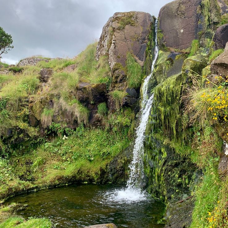
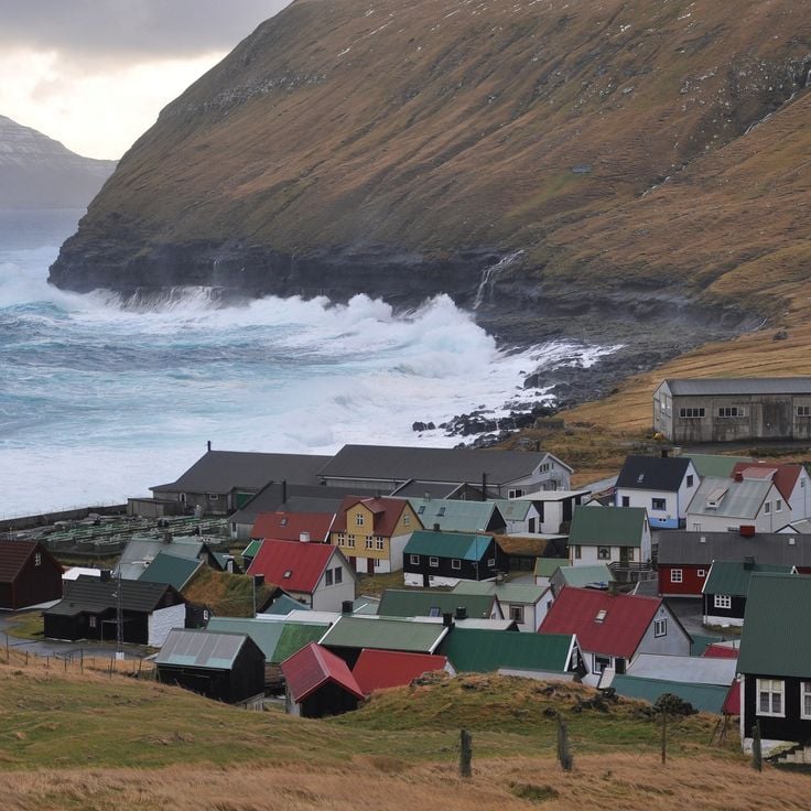
In the Faroe Islands, waterfalls pour into the ocean while villages keep their houses with grass roofs and their natural harbors.
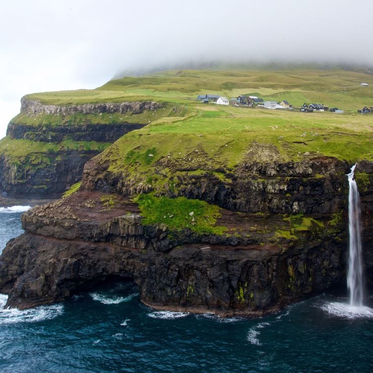
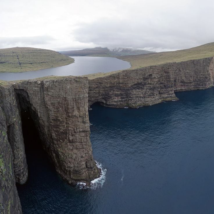
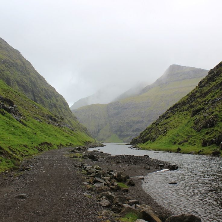
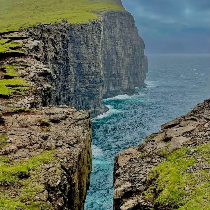
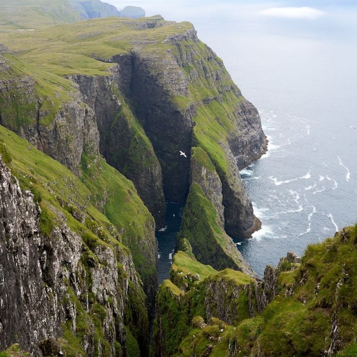
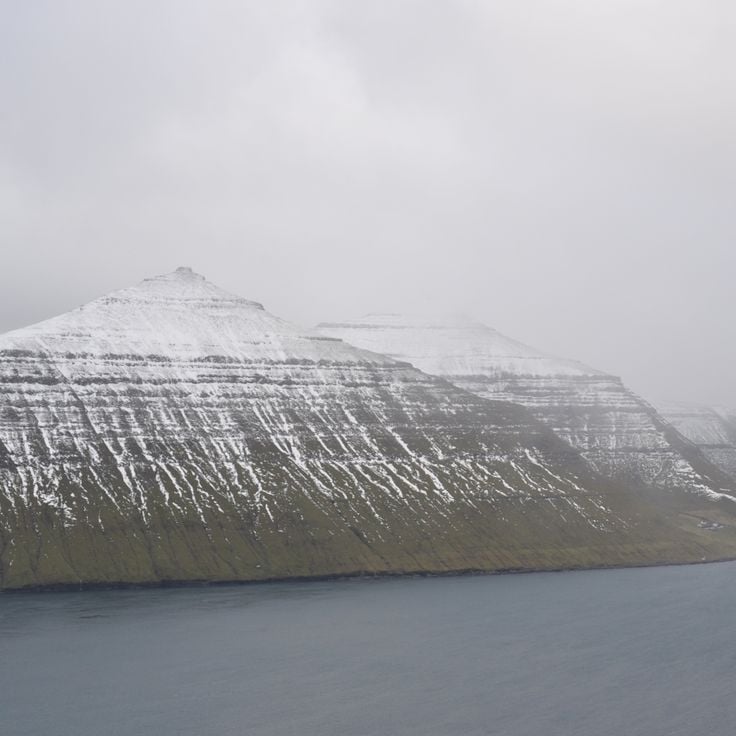
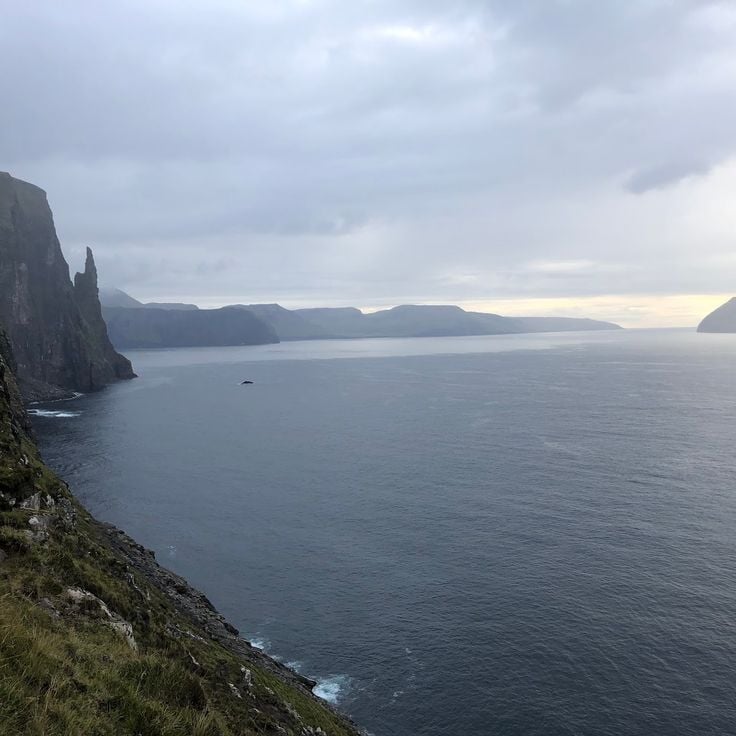
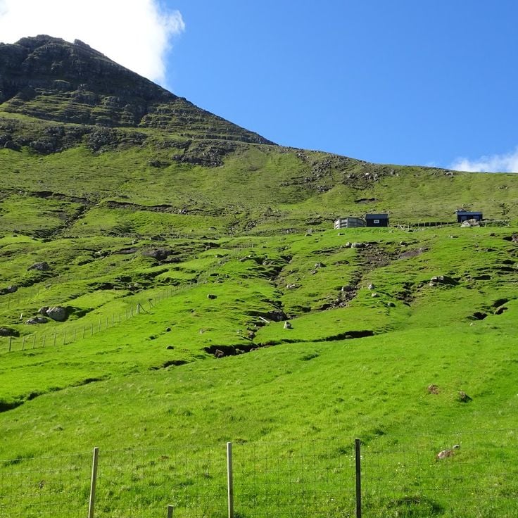
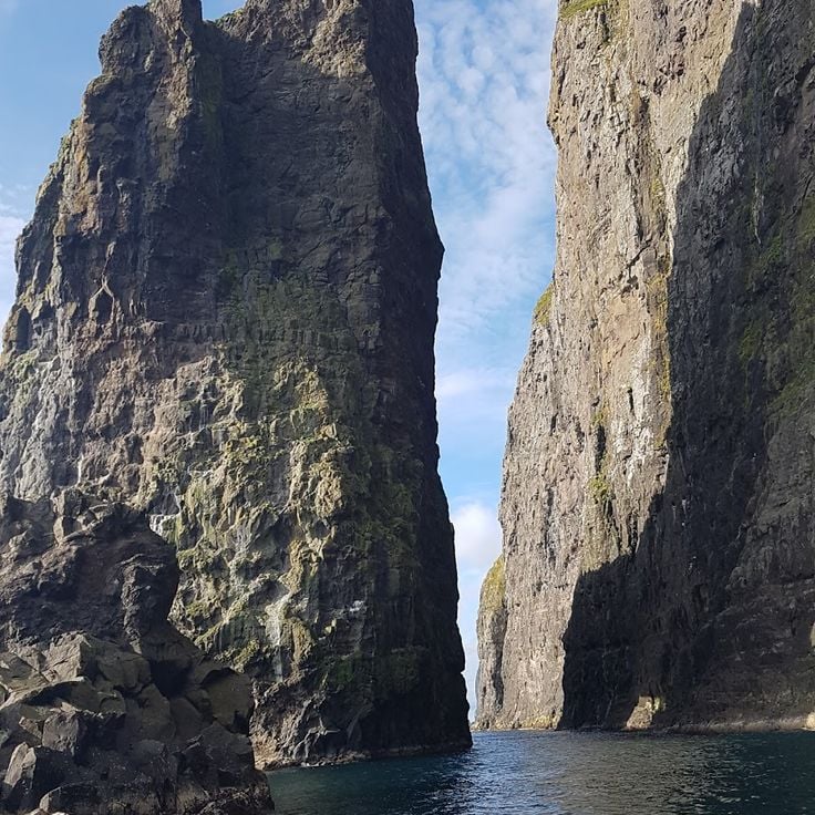
In the Faroe Islands, nature shows all its strength. Waterfalls fall directly into the ocean, cliffs rise sharply toward the sky, and lakes hide high in the mountains. Everywhere, water and rock shape the land. Sorvagsvatn lake surprises with its place between sky and sea, while the rocks of Drangarnir stand out from the water like guards. These North Atlantic islands keep a raw and wild look.
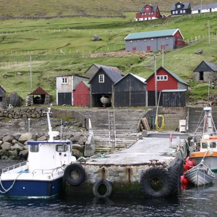
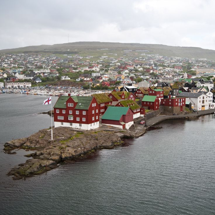
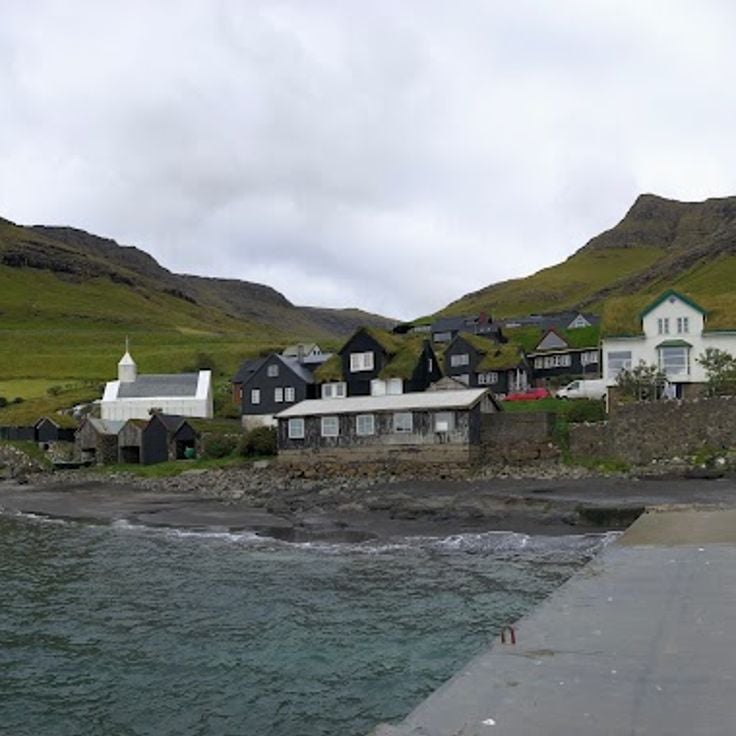
In coastal villages, traditional houses are easy to spot with roofs covered in grass that turns green in spring. Torshavn, the main town, moves with the port and sea trade. Small villages like Bøur, Saksun, and Sandavágur seem stuck in time, with old churches and natural harbors where people go down to the water. Mykines is a lonely island that offers an even more separate experience, far from the noise of the world.
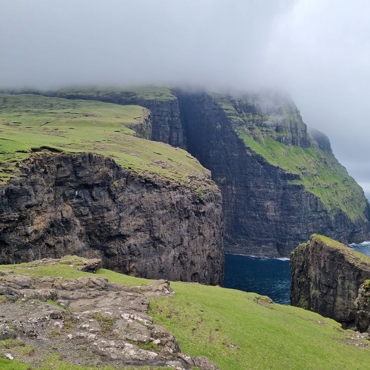
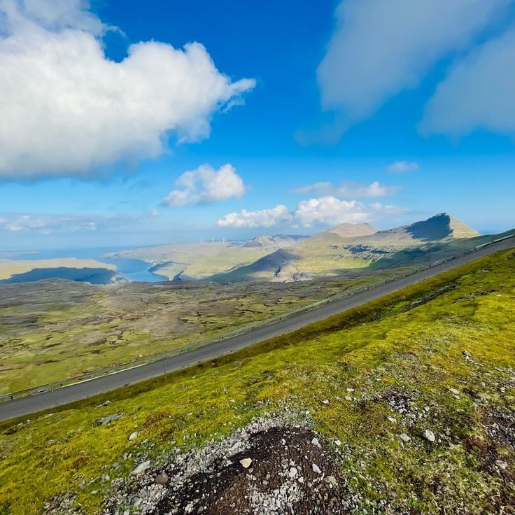
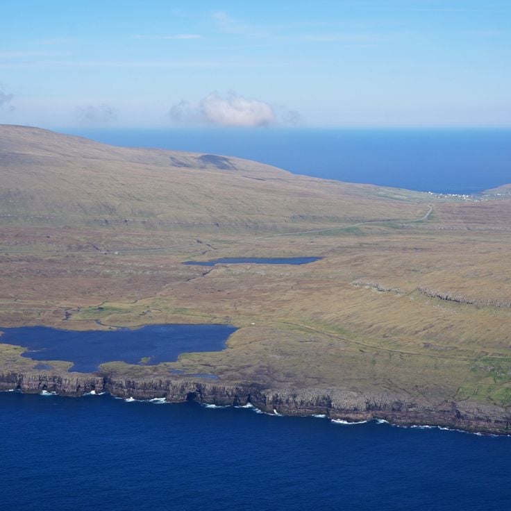
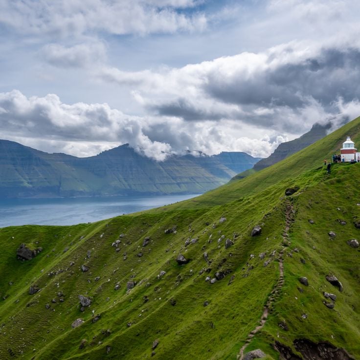
The best way to see the country is on foot. Trails wind between villages and mountain tops. They lead to viewpoints where you can see fjords going inland and mountains dropping into the sea. Each step reveals a new side of these islands where nature holds sway.
In the Faroe Islands, waterfalls pour into the ocean while villages keep their houses with grass roofs and their natural harbors.
In the Faroe Islands, nature shows all its strength. Waterfalls fall directly into the ocean, cliffs rise sharply toward the sky, and lakes hide high in the mountains. Everywhere, water and rock shape the land. Sorvagsvatn lake surprises with its place between sky and sea, while the rocks of Drangarnir stand out from the water like guards. These North Atlantic islands keep a raw and wild look.
In coastal villages, traditional houses are easy to spot with roofs covered in grass that turns green in spring. Torshavn, the main town, moves with the port and sea trade. Small villages like Bøur, Saksun, and Sandavágur seem stuck in time, with old churches and natural harbors where people go down to the water. Mykines is a lonely island that offers an even more separate experience, far from the noise of the world.
The best way to see the country is on foot. Trails wind between villages and mountain tops. They lead to viewpoints where you can see fjords going inland and mountains dropping into the sea. Each step reveals a new side of these islands where nature holds sway.
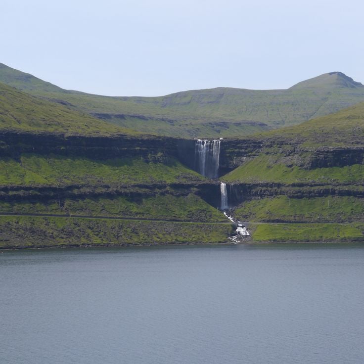
The waterfall at Gásadalur is a striking natural display where water drops 60 meters from the mountains and pours directly into the Atlantic Ocean. This cascade sits on the steep cliffs of the Faroe Islands and shows the raw power of the North Atlantic landscape that defines these islands. The waterfall reveals how water and rock continuously shape the terrain of this wild island group.
Sorvagsvatn Lake sits on Vágar island as a freshwater body of water located about 100 feet (30 meters) above sea level. From certain viewpoints, this lake creates an optical illusion where the water appears to flow directly into the ocean, though an invisible height difference separates them. The lake spans several kilometers across the landscape and stands as one of the most talked-about features of these North Atlantic islands, drawing visitors who come to experience this puzzling visual effect and witness the raw power of Faroese nature. The experience of standing here and seeing the meeting of two water bodies at different heights stays with travelers long after they leave.
Tórshavn is the capital of the Faroe Islands and sits on the island of Streymoy. This port city is the administrative and economic heart of the archipelago, where fishing remains central to daily life. Houses with grass-covered roofs line the streets, blending traditional design with modern needs. The harbor bustles with maritime activity, and you can see fishing boats and ships coming and going. Walking through Tórshavn reveals how people here depend on the sea and maintain their connection to the water. The city sits at the intersection of old Faroese traditions and contemporary island life.
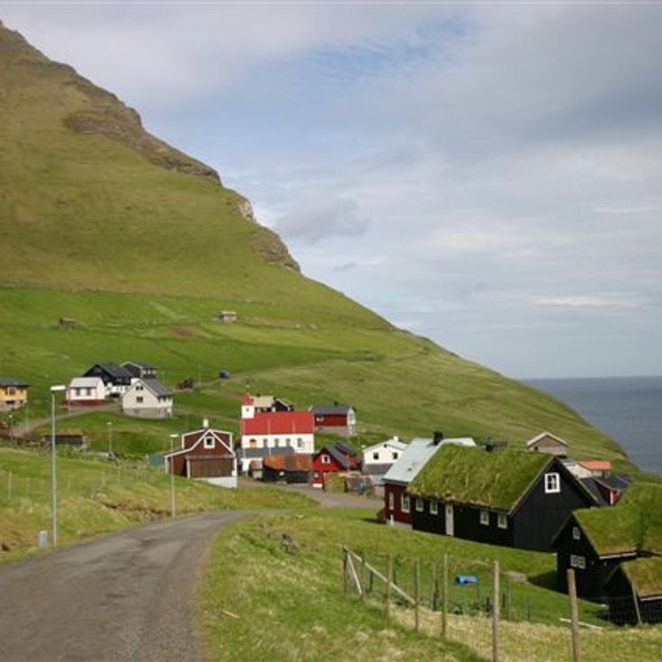
Saksun village sits on Streymoy island with a white church from the 12th century at its heart. About 14 residents live here, surrounded by a natural lagoon carved by the Atlantic Ocean. This settlement reflects the Faroe Islands character: small, isolated villages with traditional houses topped by grass-covered roofs. From here, walking trails lead to cliffs and fjords that cut into the land. The houses stand close to the water, showing how the villagers have always lived alongside the sea. Life moves slowly in this place, and the landscape dominates everything around it.
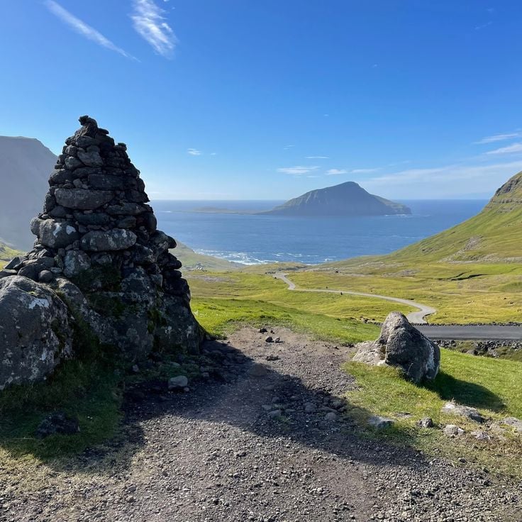
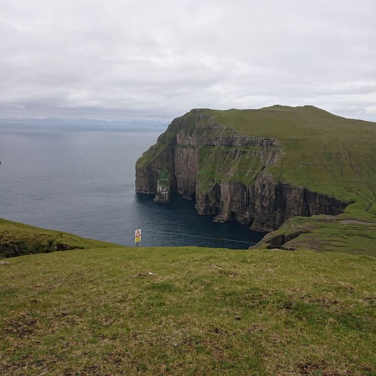
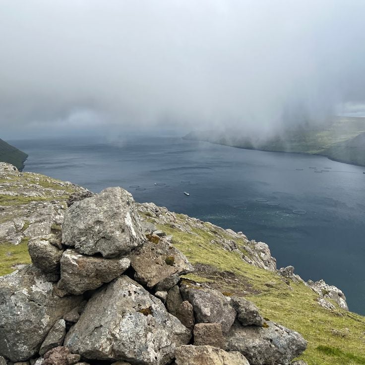
The cliffs of Trælanipa rise about 142 meters from the western coast of Vágar. Below them sits a lake, and beyond that stretches the Atlantic Ocean. These cliffs show the raw power of nature on the Faroe Islands. Standing here, you look down over a vast expanse of water and feel the scale of these North Atlantic islands.
Bøur is a small fishing village on the island of Vágar that shows how people have lived in the Faroe Islands for generations. The houses have roofs covered with grass that turn green in spring, and black wooden outbuildings stand nearby. The village sits on a natural harbor where residents can walk straight down to the water. From here you can see the island of Tindhólmur across the bay. Hiking paths lead from Bøur to viewpoints overlooking the fjords and mountains.
The Ásmundarstakkur wooden footbridge on Sandoy winds along the island's coastal cliffs and reveals the rugged seabird colonies and distinctive rock formations found throughout the Faroe Islands. Walking this path gives you a close view of how nature dominates these northern islands, with sheer drops meeting the Atlantic and birds nesting in the cliff face. The trail connects you directly to the raw landscape that defines this region.
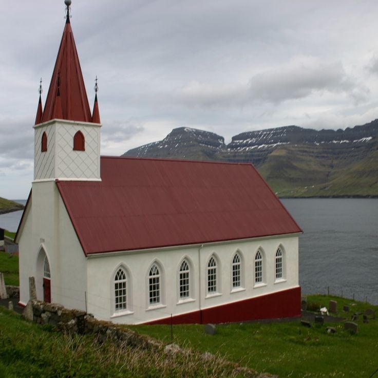
The village of Sandavágur sits on the coast of Vágar island, nestled beneath steep mountainsides. The white church built in 1917 stands as a landmark, while small wooden houses with grass-covered roofs dot the landscape along the waterfront. The fishing harbor is the heart of community life, where boats rest in the water and daily rhythms follow the tides. Narrow paths link the houses and descend to the shore, where residents have worked the sea for generations. The mountain Trøllkonufingur towers above the village, creating a raw and memorable backdrop.
The island of Mykines stands as one of the most remote places in the Faroe Islands. Steep cliffs surround the island and drop sharply to the sea. From May to September, large colonies of puffins nest here, and visitors can watch them in their natural environment. The path to the island crosses a bridge or goes by boat, and only a handful of people live here. The landscape is raw and immediate, with green grass covering the ground and shaped by strong winds.
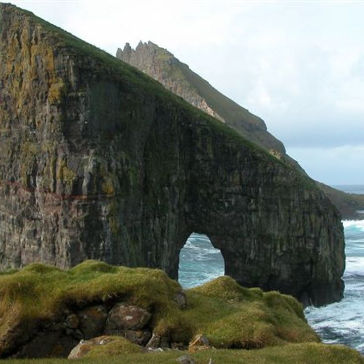
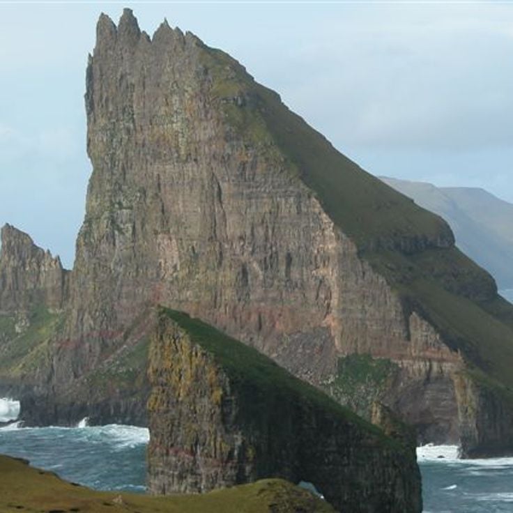
Drangarnir rocks stand off the island of Vágar as a striking pair of stone pillars rising about 70 meters (230 feet) above the ocean. A natural arch connects the two towers where they meet. Waves crash at their base and seabirds wheel around their peaks. You can see the formation from the shore or get closer by boat. The ocean has shaped these stones over thousands of years, and they remain one of the most recognizable features of the Faroe Islands.
Tjørnuvík is a fishing village on the island of Streymoy with about twenty traditional houses topped with grass-covered roofs. Situated in a valley that opens toward the North Atlantic, this village shows how people have lived and worked on these islands for generations. The houses blend into the harsh landscape, and from here you can see the power of the sea and feel the connection to nature that defines the Faroe Islands.
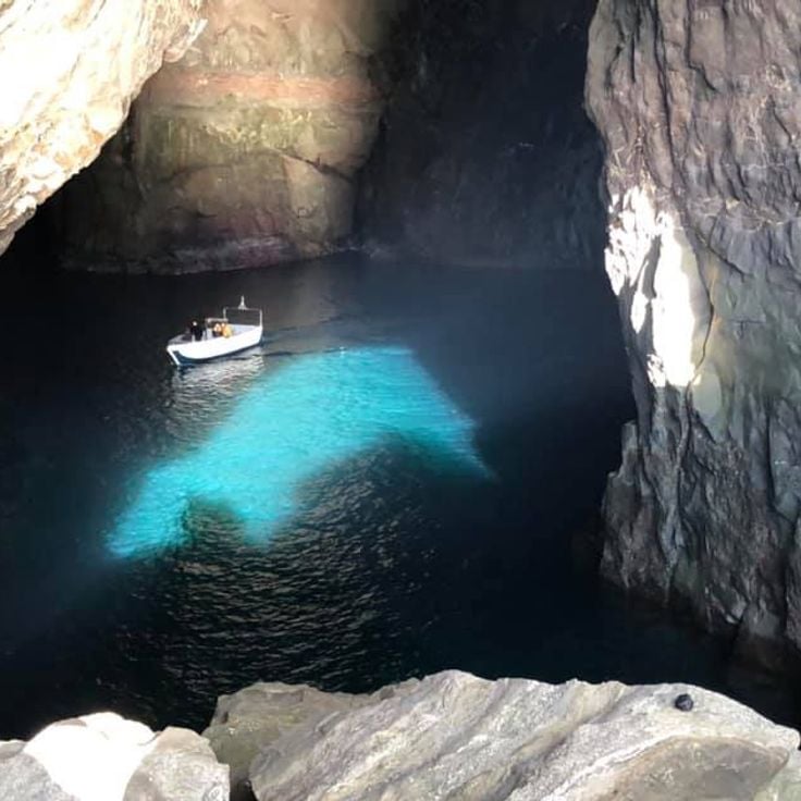
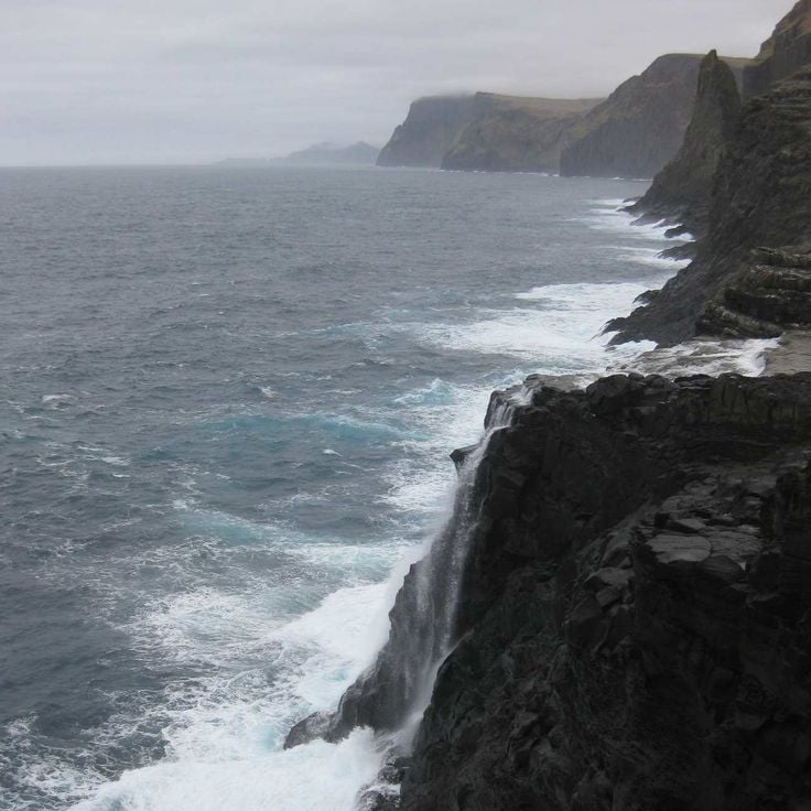
These caves can only be reached by sea, revealing the endless struggle between waves and rock. The water has carved deep hollows into the basalt cliffs, creating spaces that shift with every tide. These marine caves show the raw power of nature along the shores of the Faroe Islands.
The Dunnesdrangar are three rock columns rising sharply from the sea along the Faroe Islands coast. They were formed by natural erosion and stand as striking features of this northern landscape. A mountain trail leads to this site, offering views across the ocean and surrounding islands. The hike is part of the walking routes that crisscross these islands, where rock and water shape everything you see.
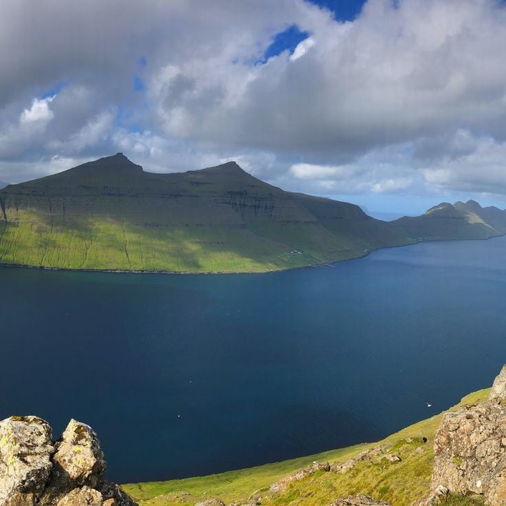
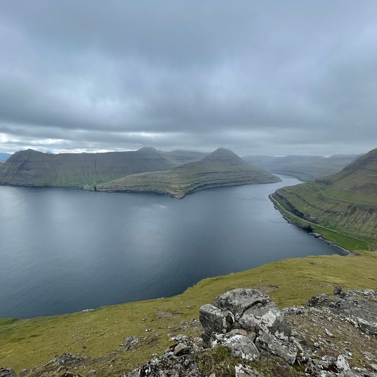
Kalsoy island displays the raw nature of the Faroe Islands. Four fishing villages stretch along this 13-kilometer-long island, their traditional houses with grass roofs shape the landscape. A lighthouse stands above cliffs that drop sharply into the sea. The ferry from Klaksvík brings you to the island. Walking paths connect the villages and reveal constant views of fjords and mountains that plunge into the ocean. This island embodies how people live here: close to the water, tied to the sea and the seasons.
Mount Sornfelli stands at 749 meters on the island of Streymoy. From its summit, you look out over the island of Vagar and the west coast of Streymoy. This mountain is part of the raw landscape of the Faroe Islands, where peaks drop sharply into the sea and water and rock shape the islands. The climb passes through terrain shaped by wind and weather. At the top, you see what these northern islands are truly like: steep slopes, dark water, and the rough beauty of the Atlantic.
The Norðadalsskarð route is a mountain road connecting the villages of Norðadalur and Syðradalur. It passes through a landscape shaped by fjords and valleys. Along the way, views open onto the water cutting deep between the mountains and the raw nature of the Faroes. This route reveals how the North Atlantic geography shapes these islands, where water and rock form the land.
Sandoy is one of the larger islands of the Faroe Islands, defined by its steep cliffs, green meadows, and several villages where residents make their living from fishing and farming. This island represents life in the Faroes in its most genuine form, where people remain deeply connected to the sea and the land. The villages on Sandoy feature traditional houses with grass-covered roofs that blend into the rolling landscape. Visitors to Sandoy experience an island where nature dominates and daily life follows the rhythm of the tides and seasons.
Trøllkonufingur is a natural rock pillar that rises steeply from the Atlantic Ocean on the southern coast of Vágar. This stone finger juts about 313 meters straight up into the sky and stands as a monument to the power of erosion over time. Waves and weather have carved and shaped this column over thousands of years, leaving it standing alone in the sea. Walkers from nearby villages like Bøur and Saksun can approach this striking formation and view it from different angles. The ocean crashes against its base, yet the pillar remains unshaken. It shows the raw geological forces that created the Faroe Islands and demonstrates the strength and wildness of nature in this North Atlantic location.
These waterfalls on Kalsoy showcase the raw power of the Faroese landscape. Water drops 50 meters straight into the ocean, creating a dramatic sight where mountain and sea meet. Located near the Kallur lighthouse, the Borgarin Falls sit in a place where you feel the full force of nature. The mist from the falling water and the sound of the cascade fill the air with energy.
Funningur is a fishing village on the east coast of Eysturoy, founded in 1840 and nestled among mountains. Traditional houses with turf roofs cling to the steep slopes, reflecting how islanders have lived with the sea and harsh landscape for centuries. The village opens toward the water, where fishermen have always moored their boats. Paths from Funningur lead to nearby peaks and along the coast, offering views where the Atlantic's power is felt directly. The settlement shows how people adapted their homes and daily rhythms to this remote northern setting.
The Kallur Lighthouse stands on the northern cliffs of Kalsoy at an elevation of 300 meters (985 feet) and serves as a key navigational landmark for ships in the region. The trail to reach it climbs over grassy mountain slopes, with views opening up at nearly every turn. From the top, you can see far out to sea while waves crash against the sheer rock faces below the lighthouse. The hike is popular with visitors seeking to experience the raw power of nature at this exposed and windswept location.
Vestmanna is a fishing port on Streymoy Island with around 1200 residents. From here, boat tours depart toward the cliffs and caves along the western coast. This settlement represents the maritime character of the Faroe Islands and provides direct access to the dramatic coastal formations that define these islands. Boats leave from here to take visitors to the sheer rock faces and hidden caves that puncture the rugged Atlantic shoreline.
Gjógv is a fishing village on Eysturoy with around 50 residents who continue traditional fishing ways. The village harbor sits in a natural crevice between tall rocks, creating a sheltered port. Houses with grass roofs cluster around this rocky inlet, their doors and paths worn by generations. This location offers a view of daily island life: fishing boats, local routines, and how people have adapted to living on steep terrain. The walk down to the harbor reveals the relationship between the villagers and the sea that has always defined this place.
Tindholmur is an uninhabited rocky island off the coast of Vágar that rises 262 meters from the sea. Its five vertical rock formations stand like sentinels against the sky and define the landscape of this part of the Faroe Islands. From the village of Bøur, visitors can see this distinctive shape clearly on the horizon. The rock shows the raw power of nature that shapes these northern islands. Hikers and photographers come to experience the dramatic coastal setting.
Bøsdalafossur waterfall on Vágar island is a dramatic natural sight where water from Lake Sorvagsvatn plunges directly over a rocky cliff into the Atlantic Ocean. This location embodies the raw power of the Faroe Islands, where water and rock shape the landscape. The roughly 30-meter-high waterfall shows how nature here follows its own rules and creates one of the most memorable views of these North Atlantic islands.
This southernmost island of the archipelago is known for its black basalt cliffs and fishing villages. Suðuroy sits south of the other islands and is reached by ferry from Tórshavn. The island displays the rugged landscape of the Faroe Islands with steep coastal cliffs that drop straight into the sea and small settlements where daily life centers on fishing. Visitors will find hiking paths that wind between villages and offer views of fjords and mountainous terrain.
Rituskor on Suðuroy is a natural rock formation where a footpath crosses a channel of seawater to reach the rock Ásmundarstakkur. This crossing brings you into direct contact with the ocean and the raw power of the North Atlantic. From this vantage point, you see how water and stone shape everything in the Faroe Islands. The walk itself takes you across grass and stone, with views that extend in all directions. This is a place where nature operates without compromise, and where the islands' wild character becomes clear.
Klakkur is a mountain peak reached by a marked trail from the parking area. From the summit, you look out over Klaksvik Fjord and the surrounding islands. The walk passes through the raw landscape of the Faroe Islands, where rock and grass shape the terrain. At the top, your view opens to the sea and mountains that drop into the water. On clear days, you can see far across the island group and understand why this place feels so wild and remote.
The Fossa waterfall on Streymoy features three water streams plunging down 140 meters over rocky cliffs before flowing directly into the North Atlantic Ocean. This waterfall is part of the raw landscape of the Faroe Islands, where water and rock shape the terrain. From different angles, the waterfall offers varying views of the rugged coastal landscape. The waterfall is most powerful during wet weather, when the water masses cascade with greater force. The site is easily accessible on foot and ranks among the most rewarding hiking destinations on the islands.
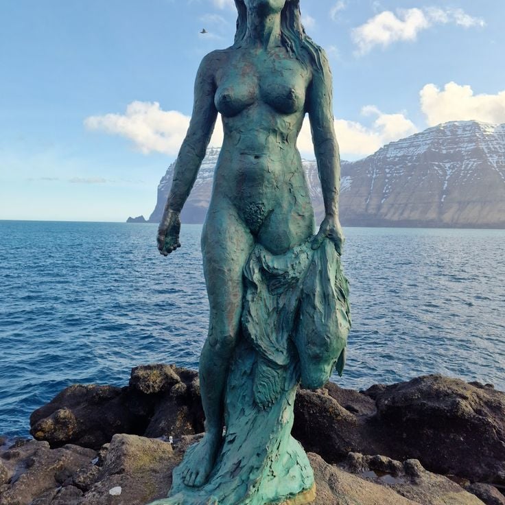
The village of Mikladalur sits on the coast of Kalsoy with the typical Faroese architecture of grass-roofed houses that turn green in spring. A modern church stands among the traditional homes of the village. A bronze statue of a selkie woman, drawn from local folklore, marks the place. Like many Faroese villages, life here remains closely tied to the sea.
Hvíthamar viewpoint sits on the island of Eysturoy and offers wide views over the village of Funningur, its fjord, and the grass-covered mountains nearby. From this height, you see how the Faroe Islands are shaped by steep slopes meeting deep water. The view reveals the raw power of these northern islands, where water and rock have formed everything around you.
The football pitch at Eidi on Eysturoy has found new life as a camping ground. It sits between the open ocean and a freshwater lake, with mountains rising at the far end. This former sports field shows how the Faroese use their landscape, creating spaces where visitors can stay close to the raw nature of these islands. From here you look out at the water and rock formations that define the Faroes, experiencing the place where human activity meets the elements.
The village of Húsar sits on the eastern coast of Kalsoy and has been a fishing settlement since the 14th century. Colorful houses with grass roofs cluster together, as is typical in the Faroe Islands. The black wooden church built in 1920 stands out for its carved door handles shaped like whales, a detail that reflects how deeply the sea shapes life here. The harbor sits right in front of the houses, and you can still see fishermen using their boats to reach the water. Húsar feels like a place where time moves slowly.
This bronze statue in Mikladalur depicts a woman in seal form and tells of an old story from Faroese folklore. The statue was installed in 2014 and stands about 2.6 meters tall. It sits in a small coastal village and recalls legends that people here have passed down for generations. The figure gazes toward the sea, as if waiting for a transformation. This statue links the raw nature of these islands with the stories that live and are told here.
The church in Funningur sits in one of these traditional Faroese villages where life remains tied to the sea. Built from wood in 1847, it stands out at once with its green grass roof that turns lush in spring. The bell tower rises on the western side, looking over the low houses around it. This church shows how the Faroes have kept their history alive - not locked away, but in buildings where people still worship and gather today.
Syðradalur is a fishing village on the west coast of Kalsoy with about 15 residents. A wooden church built in 1952 anchors the village. The harbor shelters local boats and forms the center of daily life here. Like other small settlements in the Faroe Islands, Syðradalur features traditional houses topped with grass-covered roofs. The village sits away from main routes and maintains the quiet rhythm of life that defines the smaller Faroese communities.
The waterfall at Gásadalur is a striking natural display where water drops 60 meters from the mountains and pours directly into the Atlantic Ocean. This cascade sits on the steep cliffs of the Faroe Islands and shows the raw power of the North Atlantic landscape that defines these islands. The waterfall reveals how water and rock continuously shape the terrain of this wild island group.
Sorvagsvatn Lake sits on Vágar island as a freshwater body of water located about 100 feet (30 meters) above sea level. From certain viewpoints, this lake creates an optical illusion where the water appears to flow directly into the ocean, though an invisible height difference separates them. The lake spans several kilometers across the landscape and stands as one of the most talked-about features of these North Atlantic islands, drawing visitors who come to experience this puzzling visual effect and witness the raw power of Faroese nature. The experience of standing here and seeing the meeting of two water bodies at different heights stays with travelers long after they leave.
Tórshavn is the capital of the Faroe Islands and sits on the island of Streymoy. This port city is the administrative and economic heart of the archipelago, where fishing remains central to daily life. Houses with grass-covered roofs line the streets, blending traditional design with modern needs. The harbor bustles with maritime activity, and you can see fishing boats and ships coming and going. Walking through Tórshavn reveals how people here depend on the sea and maintain their connection to the water. The city sits at the intersection of old Faroese traditions and contemporary island life.
Saksun village sits on Streymoy island with a white church from the 12th century at its heart. About 14 residents live here, surrounded by a natural lagoon carved by the Atlantic Ocean. This settlement reflects the Faroe Islands character: small, isolated villages with traditional houses topped by grass-covered roofs. From here, walking trails lead to cliffs and fjords that cut into the land. The houses stand close to the water, showing how the villagers have always lived alongside the sea. Life moves slowly in this place, and the landscape dominates everything around it.
The cliffs of Trælanipa rise about 142 meters from the western coast of Vágar. Below them sits a lake, and beyond that stretches the Atlantic Ocean. These cliffs show the raw power of nature on the Faroe Islands. Standing here, you look down over a vast expanse of water and feel the scale of these North Atlantic islands.
Bøur is a small fishing village on the island of Vágar that shows how people have lived in the Faroe Islands for generations. The houses have roofs covered with grass that turn green in spring, and black wooden outbuildings stand nearby. The village sits on a natural harbor where residents can walk straight down to the water. From here you can see the island of Tindhólmur across the bay. Hiking paths lead from Bøur to viewpoints overlooking the fjords and mountains.
The Ásmundarstakkur wooden footbridge on Sandoy winds along the island's coastal cliffs and reveals the rugged seabird colonies and distinctive rock formations found throughout the Faroe Islands. Walking this path gives you a close view of how nature dominates these northern islands, with sheer drops meeting the Atlantic and birds nesting in the cliff face. The trail connects you directly to the raw landscape that defines this region.
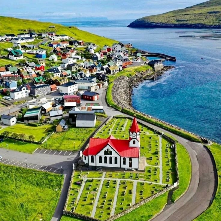
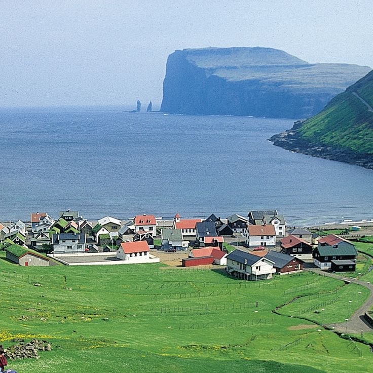
The village of Sandavágur sits on the coast of Vágar island, nestled beneath steep mountainsides. The white church built in 1917 stands as a landmark, while small wooden houses with grass-covered roofs dot the landscape along the waterfront. The fishing harbor is the heart of community life, where boats rest in the water and daily rhythms follow the tides. Narrow paths link the houses and descend to the shore, where residents have worked the sea for generations. The mountain Trøllkonufingur towers above the village, creating a raw and memorable backdrop.
The island of Mykines stands as one of the most remote places in the Faroe Islands. Steep cliffs surround the island and drop sharply to the sea. From May to September, large colonies of puffins nest here, and visitors can watch them in their natural environment. The path to the island crosses a bridge or goes by boat, and only a handful of people live here. The landscape is raw and immediate, with green grass covering the ground and shaped by strong winds.
Drangarnir rocks stand off the island of Vágar as a striking pair of stone pillars rising about 70 meters (230 feet) above the ocean. A natural arch connects the two towers where they meet. Waves crash at their base and seabirds wheel around their peaks. You can see the formation from the shore or get closer by boat. The ocean has shaped these stones over thousands of years, and they remain one of the most recognizable features of the Faroe Islands.
Tjørnuvík is a fishing village on the island of Streymoy with about twenty traditional houses topped with grass-covered roofs. Situated in a valley that opens toward the North Atlantic, this village shows how people have lived and worked on these islands for generations. The houses blend into the harsh landscape, and from here you can see the power of the sea and feel the connection to nature that defines the Faroe Islands.
These caves can only be reached by sea, revealing the endless struggle between waves and rock. The water has carved deep hollows into the basalt cliffs, creating spaces that shift with every tide. These marine caves show the raw power of nature along the shores of the Faroe Islands.
The Dunnesdrangar are three rock columns rising sharply from the sea along the Faroe Islands coast. They were formed by natural erosion and stand as striking features of this northern landscape. A mountain trail leads to this site, offering views across the ocean and surrounding islands. The hike is part of the walking routes that crisscross these islands, where rock and water shape everything you see.
Kalsoy island displays the raw nature of the Faroe Islands. Four fishing villages stretch along this 13-kilometer-long island, their traditional houses with grass roofs shape the landscape. A lighthouse stands above cliffs that drop sharply into the sea. The ferry from Klaksvík brings you to the island. Walking paths connect the villages and reveal constant views of fjords and mountains that plunge into the ocean. This island embodies how people live here: close to the water, tied to the sea and the seasons.
Mount Sornfelli stands at 749 meters on the island of Streymoy. From its summit, you look out over the island of Vagar and the west coast of Streymoy. This mountain is part of the raw landscape of the Faroe Islands, where peaks drop sharply into the sea and water and rock shape the islands. The climb passes through terrain shaped by wind and weather. At the top, you see what these northern islands are truly like: steep slopes, dark water, and the rough beauty of the Atlantic.
The Norðadalsskarð route is a mountain road connecting the villages of Norðadalur and Syðradalur. It passes through a landscape shaped by fjords and valleys. Along the way, views open onto the water cutting deep between the mountains and the raw nature of the Faroes. This route reveals how the North Atlantic geography shapes these islands, where water and rock form the land.
Sandoy is one of the larger islands of the Faroe Islands, defined by its steep cliffs, green meadows, and several villages where residents make their living from fishing and farming. This island represents life in the Faroes in its most genuine form, where people remain deeply connected to the sea and the land. The villages on Sandoy feature traditional houses with grass-covered roofs that blend into the rolling landscape. Visitors to Sandoy experience an island where nature dominates and daily life follows the rhythm of the tides and seasons.
Trøllkonufingur is a natural rock pillar that rises steeply from the Atlantic Ocean on the southern coast of Vágar. This stone finger juts about 313 meters straight up into the sky and stands as a monument to the power of erosion over time. Waves and weather have carved and shaped this column over thousands of years, leaving it standing alone in the sea. Walkers from nearby villages like Bøur and Saksun can approach this striking formation and view it from different angles. The ocean crashes against its base, yet the pillar remains unshaken. It shows the raw geological forces that created the Faroe Islands and demonstrates the strength and wildness of nature in this North Atlantic location.
These waterfalls on Kalsoy showcase the raw power of the Faroese landscape. Water drops 50 meters straight into the ocean, creating a dramatic sight where mountain and sea meet. Located near the Kallur lighthouse, the Borgarin Falls sit in a place where you feel the full force of nature. The mist from the falling water and the sound of the cascade fill the air with energy.
Funningur is a fishing village on the east coast of Eysturoy, founded in 1840 and nestled among mountains. Traditional houses with turf roofs cling to the steep slopes, reflecting how islanders have lived with the sea and harsh landscape for centuries. The village opens toward the water, where fishermen have always moored their boats. Paths from Funningur lead to nearby peaks and along the coast, offering views where the Atlantic's power is felt directly. The settlement shows how people adapted their homes and daily rhythms to this remote northern setting.
The Kallur Lighthouse stands on the northern cliffs of Kalsoy at an elevation of 300 meters (985 feet) and serves as a key navigational landmark for ships in the region. The trail to reach it climbs over grassy mountain slopes, with views opening up at nearly every turn. From the top, you can see far out to sea while waves crash against the sheer rock faces below the lighthouse. The hike is popular with visitors seeking to experience the raw power of nature at this exposed and windswept location.
Vestmanna is a fishing port on Streymoy Island with around 1200 residents. From here, boat tours depart toward the cliffs and caves along the western coast. This settlement represents the maritime character of the Faroe Islands and provides direct access to the dramatic coastal formations that define these islands. Boats leave from here to take visitors to the sheer rock faces and hidden caves that puncture the rugged Atlantic shoreline.
Gjógv is a fishing village on Eysturoy with around 50 residents who continue traditional fishing ways. The village harbor sits in a natural crevice between tall rocks, creating a sheltered port. Houses with grass roofs cluster around this rocky inlet, their doors and paths worn by generations. This location offers a view of daily island life: fishing boats, local routines, and how people have adapted to living on steep terrain. The walk down to the harbor reveals the relationship between the villagers and the sea that has always defined this place.
Tindholmur is an uninhabited rocky island off the coast of Vágar that rises 262 meters from the sea. Its five vertical rock formations stand like sentinels against the sky and define the landscape of this part of the Faroe Islands. From the village of Bøur, visitors can see this distinctive shape clearly on the horizon. The rock shows the raw power of nature that shapes these northern islands. Hikers and photographers come to experience the dramatic coastal setting.
Bøsdalafossur waterfall on Vágar island is a dramatic natural sight where water from Lake Sorvagsvatn plunges directly over a rocky cliff into the Atlantic Ocean. This location embodies the raw power of the Faroe Islands, where water and rock shape the landscape. The roughly 30-meter-high waterfall shows how nature here follows its own rules and creates one of the most memorable views of these North Atlantic islands.
This southernmost island of the archipelago is known for its black basalt cliffs and fishing villages. Suðuroy sits south of the other islands and is reached by ferry from Tórshavn. The island displays the rugged landscape of the Faroe Islands with steep coastal cliffs that drop straight into the sea and small settlements where daily life centers on fishing. Visitors will find hiking paths that wind between villages and offer views of fjords and mountainous terrain.
Rituskor on Suðuroy is a natural rock formation where a footpath crosses a channel of seawater to reach the rock Ásmundarstakkur. This crossing brings you into direct contact with the ocean and the raw power of the North Atlantic. From this vantage point, you see how water and stone shape everything in the Faroe Islands. The walk itself takes you across grass and stone, with views that extend in all directions. This is a place where nature operates without compromise, and where the islands' wild character becomes clear.
Klakkur is a mountain peak reached by a marked trail from the parking area. From the summit, you look out over Klaksvik Fjord and the surrounding islands. The walk passes through the raw landscape of the Faroe Islands, where rock and grass shape the terrain. At the top, your view opens to the sea and mountains that drop into the water. On clear days, you can see far across the island group and understand why this place feels so wild and remote.
The Fossa waterfall on Streymoy features three water streams plunging down 140 meters over rocky cliffs before flowing directly into the North Atlantic Ocean. This waterfall is part of the raw landscape of the Faroe Islands, where water and rock shape the terrain. From different angles, the waterfall offers varying views of the rugged coastal landscape. The waterfall is most powerful during wet weather, when the water masses cascade with greater force. The site is easily accessible on foot and ranks among the most rewarding hiking destinations on the islands.
The village of Mikladalur sits on the coast of Kalsoy with the typical Faroese architecture of grass-roofed houses that turn green in spring. A modern church stands among the traditional homes of the village. A bronze statue of a selkie woman, drawn from local folklore, marks the place. Like many Faroese villages, life here remains closely tied to the sea.
Hvíthamar viewpoint sits on the island of Eysturoy and offers wide views over the village of Funningur, its fjord, and the grass-covered mountains nearby. From this height, you see how the Faroe Islands are shaped by steep slopes meeting deep water. The view reveals the raw power of these northern islands, where water and rock have formed everything around you.
The football pitch at Eidi on Eysturoy has found new life as a camping ground. It sits between the open ocean and a freshwater lake, with mountains rising at the far end. This former sports field shows how the Faroese use their landscape, creating spaces where visitors can stay close to the raw nature of these islands. From here you look out at the water and rock formations that define the Faroes, experiencing the place where human activity meets the elements.
The village of Húsar sits on the eastern coast of Kalsoy and has been a fishing settlement since the 14th century. Colorful houses with grass roofs cluster together, as is typical in the Faroe Islands. The black wooden church built in 1920 stands out for its carved door handles shaped like whales, a detail that reflects how deeply the sea shapes life here. The harbor sits right in front of the houses, and you can still see fishermen using their boats to reach the water. Húsar feels like a place where time moves slowly.
This bronze statue in Mikladalur depicts a woman in seal form and tells of an old story from Faroese folklore. The statue was installed in 2014 and stands about 2.6 meters tall. It sits in a small coastal village and recalls legends that people here have passed down for generations. The figure gazes toward the sea, as if waiting for a transformation. This statue links the raw nature of these islands with the stories that live and are told here.
The church in Funningur sits in one of these traditional Faroese villages where life remains tied to the sea. Built from wood in 1847, it stands out at once with its green grass roof that turns lush in spring. The bell tower rises on the western side, looking over the low houses around it. This church shows how the Faroes have kept their history alive - not locked away, but in buildings where people still worship and gather today.
Syðradalur is a fishing village on the west coast of Kalsoy with about 15 residents. A wooden church built in 1952 anchors the village. The harbor shelters local boats and forms the center of daily life here. Like other small settlements in the Faroe Islands, Syðradalur features traditional houses topped with grass-covered roofs. The village sits away from main routes and maintains the quiet rhythm of life that defines the smaller Faroese communities.
The waterfall at Gásadalur is a striking natural display where water drops 60 meters from the mountains and pours directly into the Atlantic Ocean. This cascade sits on the steep cliffs of the Faroe Islands and shows the raw power of the North Atlantic landscape that defines these islands. The waterfall reveals how water and rock continuously shape the terrain of this wild island group.
Sorvagsvatn Lake sits on Vágar island as a freshwater body of water located about 100 feet (30 meters) above sea level. From certain viewpoints, this lake creates an optical illusion where the water appears to flow directly into the ocean, though an invisible height difference separates them. The lake spans several kilometers across the landscape and stands as one of the most talked-about features of these North Atlantic islands, drawing visitors who come to experience this puzzling visual effect and witness the raw power of Faroese nature. The experience of standing here and seeing the meeting of two water bodies at different heights stays with travelers long after they leave.
Tórshavn is the capital of the Faroe Islands and sits on the island of Streymoy. This port city is the administrative and economic heart of the archipelago, where fishing remains central to daily life. Houses with grass-covered roofs line the streets, blending traditional design with modern needs. The harbor bustles with maritime activity, and you can see fishing boats and ships coming and going. Walking through Tórshavn reveals how people here depend on the sea and maintain their connection to the water. The city sits at the intersection of old Faroese traditions and contemporary island life.
Saksun village sits on Streymoy island with a white church from the 12th century at its heart. About 14 residents live here, surrounded by a natural lagoon carved by the Atlantic Ocean. This settlement reflects the Faroe Islands character: small, isolated villages with traditional houses topped by grass-covered roofs. From here, walking trails lead to cliffs and fjords that cut into the land. The houses stand close to the water, showing how the villagers have always lived alongside the sea. Life moves slowly in this place, and the landscape dominates everything around it.
The cliffs of Trælanipa rise about 142 meters from the western coast of Vágar. Below them sits a lake, and beyond that stretches the Atlantic Ocean. These cliffs show the raw power of nature on the Faroe Islands. Standing here, you look down over a vast expanse of water and feel the scale of these North Atlantic islands.
Bøur is a small fishing village on the island of Vágar that shows how people have lived in the Faroe Islands for generations. The houses have roofs covered with grass that turn green in spring, and black wooden outbuildings stand nearby. The village sits on a natural harbor where residents can walk straight down to the water. From here you can see the island of Tindhólmur across the bay. Hiking paths lead from Bøur to viewpoints overlooking the fjords and mountains.
The Ásmundarstakkur wooden footbridge on Sandoy winds along the island's coastal cliffs and reveals the rugged seabird colonies and distinctive rock formations found throughout the Faroe Islands. Walking this path gives you a close view of how nature dominates these northern islands, with sheer drops meeting the Atlantic and birds nesting in the cliff face. The trail connects you directly to the raw landscape that defines this region.
The village of Sandavágur sits on the coast of Vágar island, nestled beneath steep mountainsides. The white church built in 1917 stands as a landmark, while small wooden houses with grass-covered roofs dot the landscape along the waterfront. The fishing harbor is the heart of community life, where boats rest in the water and daily rhythms follow the tides. Narrow paths link the houses and descend to the shore, where residents have worked the sea for generations. The mountain Trøllkonufingur towers above the village, creating a raw and memorable backdrop.
The island of Mykines stands as one of the most remote places in the Faroe Islands. Steep cliffs surround the island and drop sharply to the sea. From May to September, large colonies of puffins nest here, and visitors can watch them in their natural environment. The path to the island crosses a bridge or goes by boat, and only a handful of people live here. The landscape is raw and immediate, with green grass covering the ground and shaped by strong winds.
Drangarnir rocks stand off the island of Vágar as a striking pair of stone pillars rising about 70 meters (230 feet) above the ocean. A natural arch connects the two towers where they meet. Waves crash at their base and seabirds wheel around their peaks. You can see the formation from the shore or get closer by boat. The ocean has shaped these stones over thousands of years, and they remain one of the most recognizable features of the Faroe Islands.
Tjørnuvík is a fishing village on the island of Streymoy with about twenty traditional houses topped with grass-covered roofs. Situated in a valley that opens toward the North Atlantic, this village shows how people have lived and worked on these islands for generations. The houses blend into the harsh landscape, and from here you can see the power of the sea and feel the connection to nature that defines the Faroe Islands.
These caves can only be reached by sea, revealing the endless struggle between waves and rock. The water has carved deep hollows into the basalt cliffs, creating spaces that shift with every tide. These marine caves show the raw power of nature along the shores of the Faroe Islands.
The Dunnesdrangar are three rock columns rising sharply from the sea along the Faroe Islands coast. They were formed by natural erosion and stand as striking features of this northern landscape. A mountain trail leads to this site, offering views across the ocean and surrounding islands. The hike is part of the walking routes that crisscross these islands, where rock and water shape everything you see.
Kalsoy island displays the raw nature of the Faroe Islands. Four fishing villages stretch along this 13-kilometer-long island, their traditional houses with grass roofs shape the landscape. A lighthouse stands above cliffs that drop sharply into the sea. The ferry from Klaksvík brings you to the island. Walking paths connect the villages and reveal constant views of fjords and mountains that plunge into the ocean. This island embodies how people live here: close to the water, tied to the sea and the seasons.
Mount Sornfelli stands at 749 meters on the island of Streymoy. From its summit, you look out over the island of Vagar and the west coast of Streymoy. This mountain is part of the raw landscape of the Faroe Islands, where peaks drop sharply into the sea and water and rock shape the islands. The climb passes through terrain shaped by wind and weather. At the top, you see what these northern islands are truly like: steep slopes, dark water, and the rough beauty of the Atlantic.
The Norðadalsskarð route is a mountain road connecting the villages of Norðadalur and Syðradalur. It passes through a landscape shaped by fjords and valleys. Along the way, views open onto the water cutting deep between the mountains and the raw nature of the Faroes. This route reveals how the North Atlantic geography shapes these islands, where water and rock form the land.
Sandoy is one of the larger islands of the Faroe Islands, defined by its steep cliffs, green meadows, and several villages where residents make their living from fishing and farming. This island represents life in the Faroes in its most genuine form, where people remain deeply connected to the sea and the land. The villages on Sandoy feature traditional houses with grass-covered roofs that blend into the rolling landscape. Visitors to Sandoy experience an island where nature dominates and daily life follows the rhythm of the tides and seasons.
Trøllkonufingur is a natural rock pillar that rises steeply from the Atlantic Ocean on the southern coast of Vágar. This stone finger juts about 313 meters straight up into the sky and stands as a monument to the power of erosion over time. Waves and weather have carved and shaped this column over thousands of years, leaving it standing alone in the sea. Walkers from nearby villages like Bøur and Saksun can approach this striking formation and view it from different angles. The ocean crashes against its base, yet the pillar remains unshaken. It shows the raw geological forces that created the Faroe Islands and demonstrates the strength and wildness of nature in this North Atlantic location.
These waterfalls on Kalsoy showcase the raw power of the Faroese landscape. Water drops 50 meters straight into the ocean, creating a dramatic sight where mountain and sea meet. Located near the Kallur lighthouse, the Borgarin Falls sit in a place where you feel the full force of nature. The mist from the falling water and the sound of the cascade fill the air with energy.
Funningur is a fishing village on the east coast of Eysturoy, founded in 1840 and nestled among mountains. Traditional houses with turf roofs cling to the steep slopes, reflecting how islanders have lived with the sea and harsh landscape for centuries. The village opens toward the water, where fishermen have always moored their boats. Paths from Funningur lead to nearby peaks and along the coast, offering views where the Atlantic's power is felt directly. The settlement shows how people adapted their homes and daily rhythms to this remote northern setting.
The Kallur Lighthouse stands on the northern cliffs of Kalsoy at an elevation of 300 meters (985 feet) and serves as a key navigational landmark for ships in the region. The trail to reach it climbs over grassy mountain slopes, with views opening up at nearly every turn. From the top, you can see far out to sea while waves crash against the sheer rock faces below the lighthouse. The hike is popular with visitors seeking to experience the raw power of nature at this exposed and windswept location.
Vestmanna is a fishing port on Streymoy Island with around 1200 residents. From here, boat tours depart toward the cliffs and caves along the western coast. This settlement represents the maritime character of the Faroe Islands and provides direct access to the dramatic coastal formations that define these islands. Boats leave from here to take visitors to the sheer rock faces and hidden caves that puncture the rugged Atlantic shoreline.
Gjógv is a fishing village on Eysturoy with around 50 residents who continue traditional fishing ways. The village harbor sits in a natural crevice between tall rocks, creating a sheltered port. Houses with grass roofs cluster around this rocky inlet, their doors and paths worn by generations. This location offers a view of daily island life: fishing boats, local routines, and how people have adapted to living on steep terrain. The walk down to the harbor reveals the relationship between the villagers and the sea that has always defined this place.
Tindholmur is an uninhabited rocky island off the coast of Vágar that rises 262 meters from the sea. Its five vertical rock formations stand like sentinels against the sky and define the landscape of this part of the Faroe Islands. From the village of Bøur, visitors can see this distinctive shape clearly on the horizon. The rock shows the raw power of nature that shapes these northern islands. Hikers and photographers come to experience the dramatic coastal setting.
Bøsdalafossur waterfall on Vágar island is a dramatic natural sight where water from Lake Sorvagsvatn plunges directly over a rocky cliff into the Atlantic Ocean. This location embodies the raw power of the Faroe Islands, where water and rock shape the landscape. The roughly 30-meter-high waterfall shows how nature here follows its own rules and creates one of the most memorable views of these North Atlantic islands.
This southernmost island of the archipelago is known for its black basalt cliffs and fishing villages. Suðuroy sits south of the other islands and is reached by ferry from Tórshavn. The island displays the rugged landscape of the Faroe Islands with steep coastal cliffs that drop straight into the sea and small settlements where daily life centers on fishing. Visitors will find hiking paths that wind between villages and offer views of fjords and mountainous terrain.
Rituskor on Suðuroy is a natural rock formation where a footpath crosses a channel of seawater to reach the rock Ásmundarstakkur. This crossing brings you into direct contact with the ocean and the raw power of the North Atlantic. From this vantage point, you see how water and stone shape everything in the Faroe Islands. The walk itself takes you across grass and stone, with views that extend in all directions. This is a place where nature operates without compromise, and where the islands' wild character becomes clear.
Klakkur is a mountain peak reached by a marked trail from the parking area. From the summit, you look out over Klaksvik Fjord and the surrounding islands. The walk passes through the raw landscape of the Faroe Islands, where rock and grass shape the terrain. At the top, your view opens to the sea and mountains that drop into the water. On clear days, you can see far across the island group and understand why this place feels so wild and remote.
The Fossa waterfall on Streymoy features three water streams plunging down 140 meters over rocky cliffs before flowing directly into the North Atlantic Ocean. This waterfall is part of the raw landscape of the Faroe Islands, where water and rock shape the terrain. From different angles, the waterfall offers varying views of the rugged coastal landscape. The waterfall is most powerful during wet weather, when the water masses cascade with greater force. The site is easily accessible on foot and ranks among the most rewarding hiking destinations on the islands.
The village of Mikladalur sits on the coast of Kalsoy with the typical Faroese architecture of grass-roofed houses that turn green in spring. A modern church stands among the traditional homes of the village. A bronze statue of a selkie woman, drawn from local folklore, marks the place. Like many Faroese villages, life here remains closely tied to the sea.
Hvíthamar viewpoint sits on the island of Eysturoy and offers wide views over the village of Funningur, its fjord, and the grass-covered mountains nearby. From this height, you see how the Faroe Islands are shaped by steep slopes meeting deep water. The view reveals the raw power of these northern islands, where water and rock have formed everything around you.
The football pitch at Eidi on Eysturoy has found new life as a camping ground. It sits between the open ocean and a freshwater lake, with mountains rising at the far end. This former sports field shows how the Faroese use their landscape, creating spaces where visitors can stay close to the raw nature of these islands. From here you look out at the water and rock formations that define the Faroes, experiencing the place where human activity meets the elements.
The village of Húsar sits on the eastern coast of Kalsoy and has been a fishing settlement since the 14th century. Colorful houses with grass roofs cluster together, as is typical in the Faroe Islands. The black wooden church built in 1920 stands out for its carved door handles shaped like whales, a detail that reflects how deeply the sea shapes life here. The harbor sits right in front of the houses, and you can still see fishermen using their boats to reach the water. Húsar feels like a place where time moves slowly.
This bronze statue in Mikladalur depicts a woman in seal form and tells of an old story from Faroese folklore. The statue was installed in 2014 and stands about 2.6 meters tall. It sits in a small coastal village and recalls legends that people here have passed down for generations. The figure gazes toward the sea, as if waiting for a transformation. This statue links the raw nature of these islands with the stories that live and are told here.
The church in Funningur sits in one of these traditional Faroese villages where life remains tied to the sea. Built from wood in 1847, it stands out at once with its green grass roof that turns lush in spring. The bell tower rises on the western side, looking over the low houses around it. This church shows how the Faroes have kept their history alive - not locked away, but in buildings where people still worship and gather today.
Syðradalur is a fishing village on the west coast of Kalsoy with about 15 residents. A wooden church built in 1952 anchors the village. The harbor shelters local boats and forms the center of daily life here. Like other small settlements in the Faroe Islands, Syðradalur features traditional houses topped with grass-covered roofs. The village sits away from main routes and maintains the quiet rhythm of life that defines the smaller Faroese communities.
Try the local food based on fish, lamb, and seafood. Sample ræst, air-dried sheep meat, and suaasat, a traditional broth. The restaurants are mostly in the bigger villages, so plan your meals ahead.