Natural wonders and heritage sites in northern Brazil
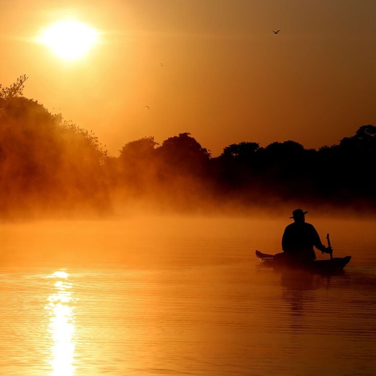
Northern Brazil holds a range of natural areas and historical sites away from the usual tourist paths. The region stretches from the Amazon basin to the wide plateaus of the Cerrado, offering waterfalls, clear springs, sand dunes, canyons, and caves. Protected areas such as Jalapão State Park and Anavilhanas National Park shelter rare animals and native plants. Rivers wind through dense forests, and in some springs, mineral-rich water pushes swimmers to the surface. The landscape shifts between tropical rainforest, open grasslands, and rock formations shaped over thousands of years.
Notable places include the golden sand dunes of Jalapão, the tall waterfalls of Cachoeira da Velha and Cachoeira do Lajeado, and the natural pools known as fervedouros, where visitors can float effortlessly. Pedra Furada, a natural stone arch, and Canyon Encantado show the geological variety of the region. Ilha do Bananal, one of the largest river islands in the world, sits in the Araguaia River and provides habitat for many bird species. Further north, the Amazon rainforest spreads out with its branching rivers and islands. The colonial Fort Príncipe da Beira, built in the 18th century, recalls early European settlement. In Natividade, the small church of Nossa Senhora do Rosário stands as a modest example of colonial architecture. These places combine nature and history, inviting travelers to discover a less familiar side of Brazil.
Natural wonders and heritage sites in northern Brazil
Northern Brazil holds a range of natural areas and historical sites away from the usual tourist paths. The region stretches from the Amazon basin to the wide plateaus of the Cerrado, offering waterfalls, clear springs, sand dunes, canyons, and caves. Protected areas such as Jalapão State Park and Anavilhanas National Park shelter rare animals and native plants. Rivers wind through dense forests, and in some springs, mineral-rich water pushes swimmers to the surface. The landscape shifts between tropical rainforest, open grasslands, and rock formations shaped over thousands of years.
Notable places include the golden sand dunes of Jalapão, the tall waterfalls of Cachoeira da Velha and Cachoeira do Lajeado, and the natural pools known as fervedouros, where visitors can float effortlessly. Pedra Furada, a natural stone arch, and Canyon Encantado show the geological variety of the region. Ilha do Bananal, one of the largest river islands in the world, sits in the Araguaia River and provides habitat for many bird species. Further north, the Amazon rainforest spreads out with its branching rivers and islands. The colonial Fort Príncipe da Beira, built in the 18th century, recalls early European settlement. In Natividade, the small church of Nossa Senhora do Rosário stands as a modest example of colonial architecture. These places combine nature and history, inviting travelers to discover a less familiar side of Brazil.
This park covers several vegetation zones with savanna and forest. Many native animal species live in this area, which belongs to the protected natural areas in northern Brazil. The landscape shifts between open grassland and wooded sections, where visitors can observe the plant life and wildlife of the region.
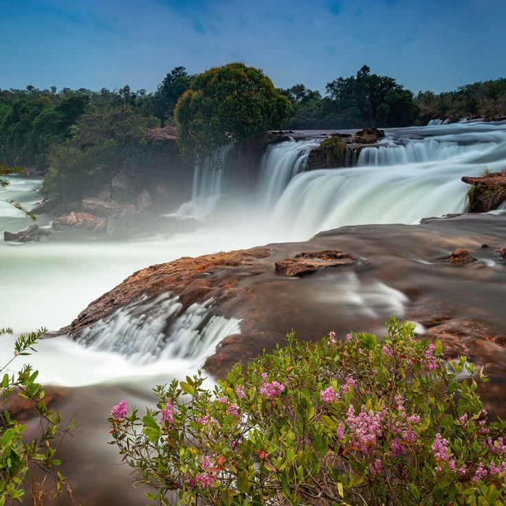
This waterfall drops over a wide rock edge. Water splits into two main branches and falls from about 100 meters. Cachoeira da Velha sits in tropical savanna landscape that belongs to Jalapão. Rocks frame the basin, and palm trees grow along the banks. Visitors reach the site on unpaved roads through open terrain with low trees and grasses. At the base of the falls, water gathers in a shallow pool. The current is gentle enough for wading in many spots.
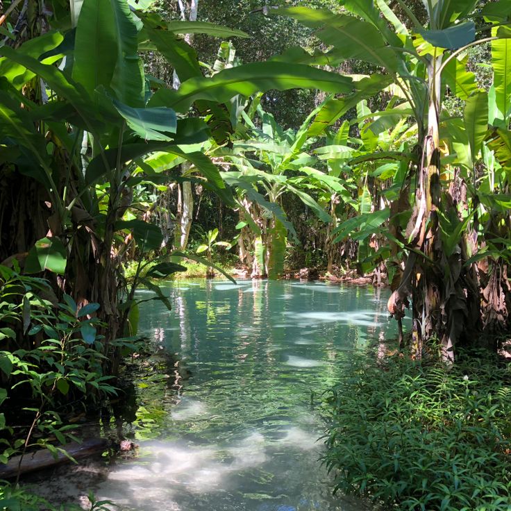
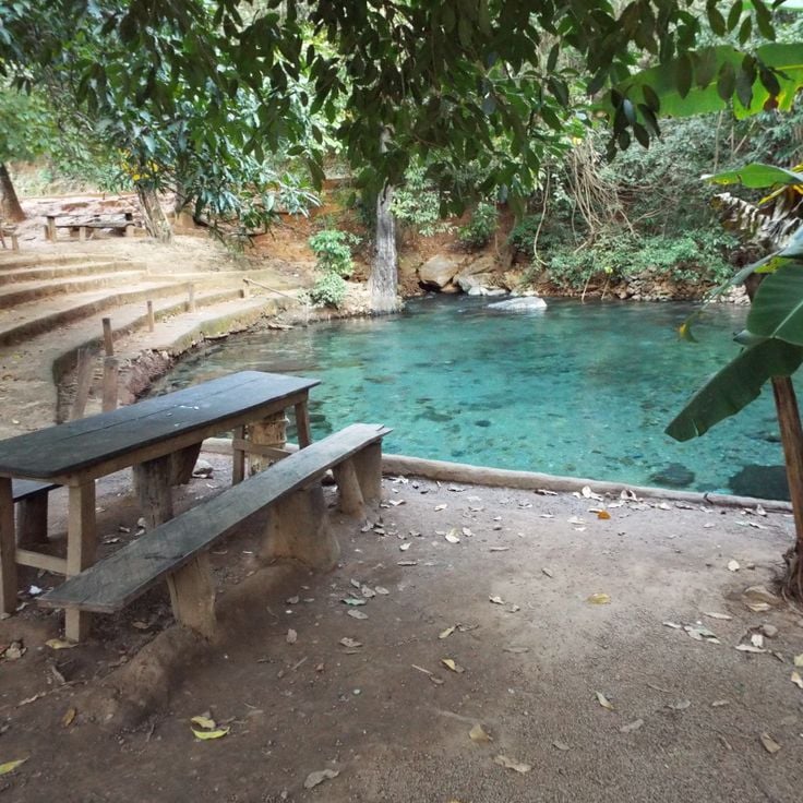
This spring bubbles up through layers of sand and creates a natural buoyancy that keeps visitors floating on the surface. The water of Fervedouro do Ceiça rises continuously from below, making it physically impossible to sink. The spring sits in a remote area of the Jalapão region and belongs to the geological features of northern Brazil, where groundwater pushes upward through porous rock formations.
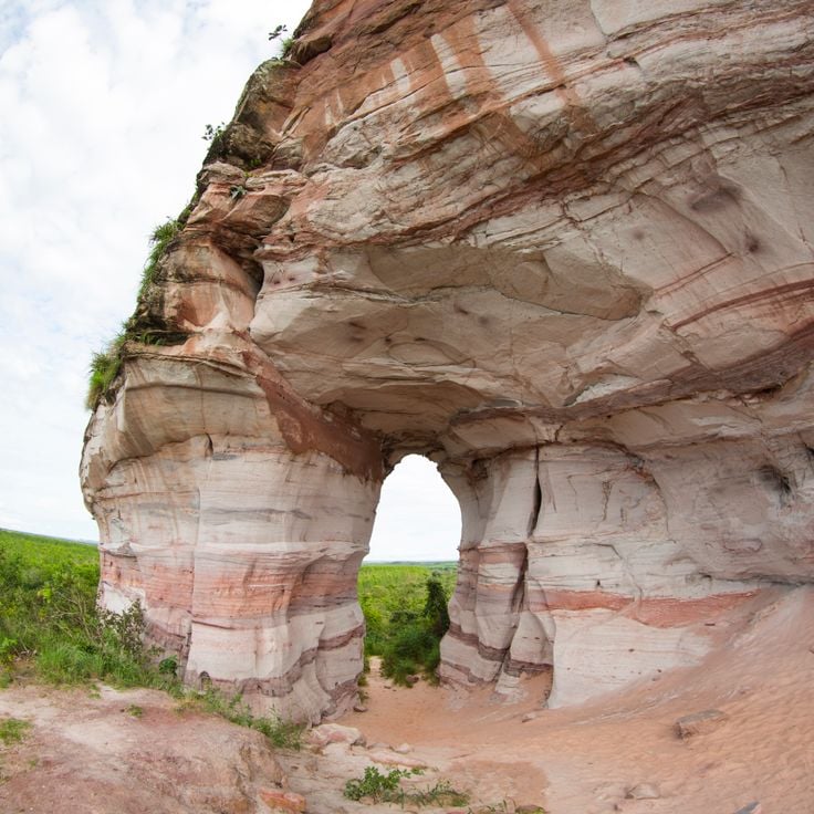
This natural rock arch rises in the Tocantins landscape. The large opening in the middle formed through wind and rain over long periods. Walking trails lead to Pedra Furada, where visitors can view the rock formation up close. The site lies in a region with other geological features and works well for trips into northern Brazil's natural areas.
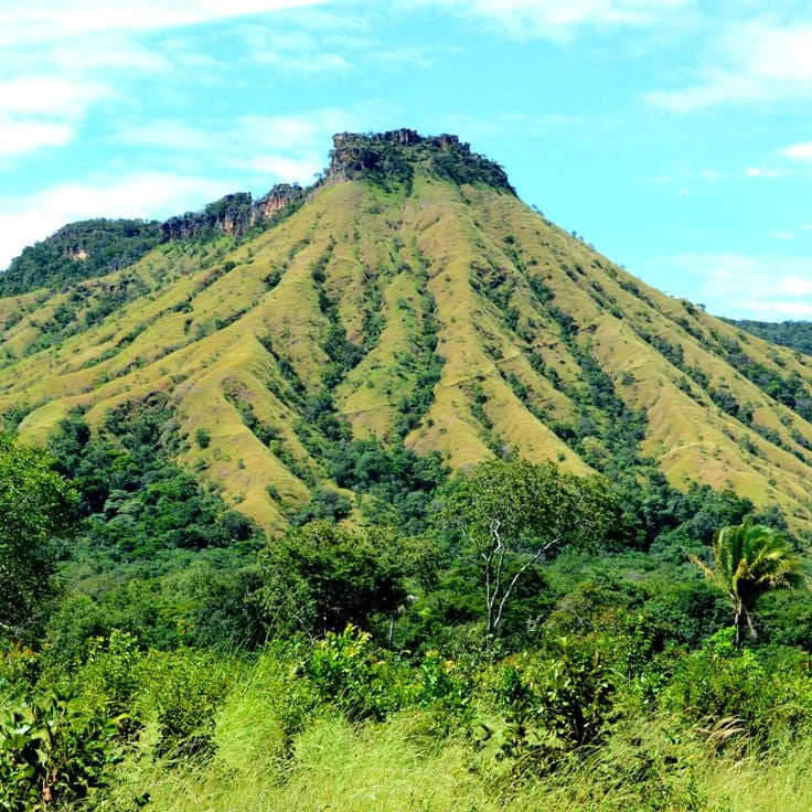
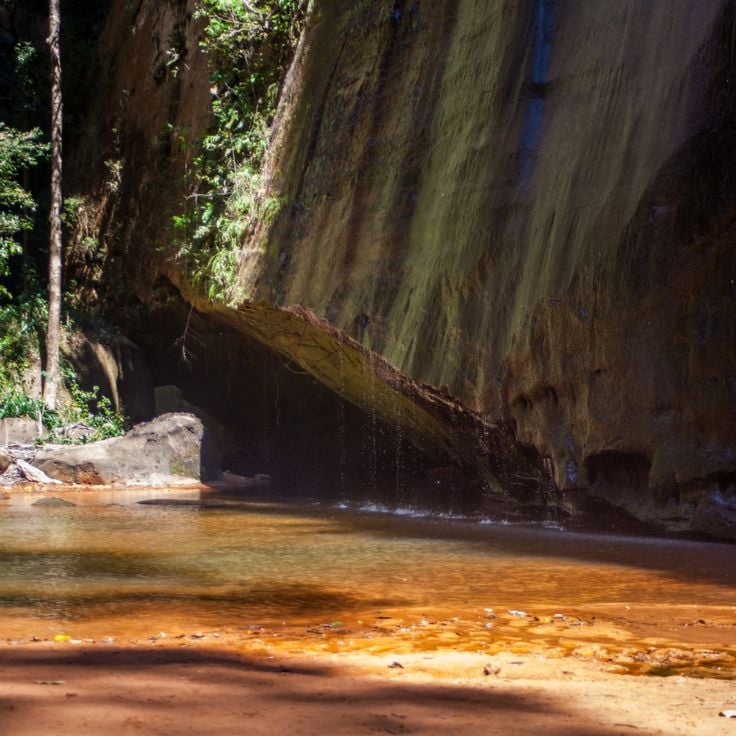
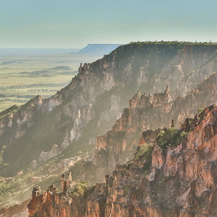
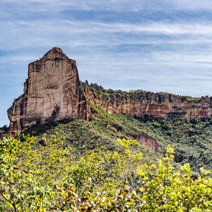
This canyon forms a valley with rock walls rising about 100 meters (330 feet), while at the bottom a mountain stream flows through the narrow gorge and makes the reddish stone glow in different shades, shaped by erosion over a long period, and visitors can hike along the watercourse and discover pools that have formed between the rocks.
This river island sits in the Araguaia River and is one of the largest inland islands in the world. It stretches across wide floodplains, marshes and gallery forests that change with the seasons. The island is home to several indigenous communities who have lived with the river cycles for centuries. Over five hundred bird species have been recorded here, including herons, storks and macaws. During the dry season, sandy beaches appear along the riverbanks, while the rainy season floods large parts of the landscape. Ilha do Bananal belongs to Araguaia National Park and connects Amazon and Cerrado ecosystems. Visitors can take canoe trips, watch birds and learn about local cultures that maintain their traditional ways of life.
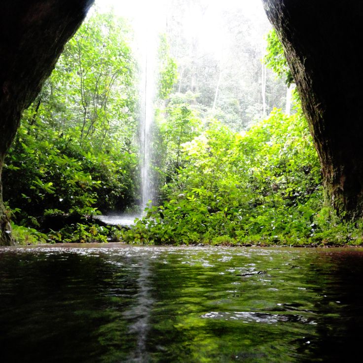
This waterfall in northern Brazil drops about a hundred feet into a natural pool below. The surrounding forest belongs to a region with little development and few visitors. Travelers reach the site by unpaved roads that cross dry vegetation, and they can swim in the cool water of the basin.
Serra das Andorinhas is a large nature reserve in the Brazilian Amazon with rainforests, rock formations and waterfalls. This region is home to many bird species and other animals. Visitors can follow trails through dense forest and discover caves with prehistoric paintings that show evidence of ancient cultures.
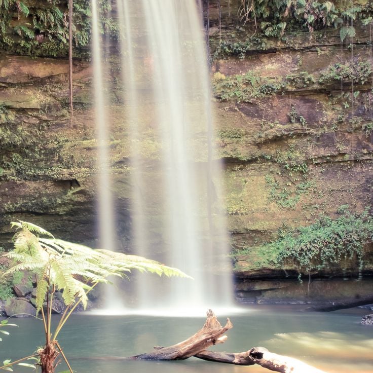
This waterfall drops into a natural basin with turquoise water in Jalapão State Park. The water gets its color from minerals in the rock and flows from a spring nearby. Visitors swim in the clear, cool water. The waterfall is about an hour's walk from the access road and is among the natural formations in this part of northern Brazil.
This river shows blue water for about 147 meters (482 feet), clear enough to see the bottom. Rio Azuis sits in an area with tropical climate, where natural filtration creates the transparent flow. The river forms a narrow corridor between green vegetation, and visitors can walk along the banks and enter the water. The temperature stays consistently cool throughout the year. This site belongs to the natural areas in northern Brazil that remain away from regular tourist routes.
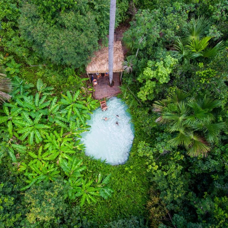
This natural water basin in the remote Chapada das Mesas region forms where spring water pushes upward through sandy ground. The water flows continuously from below, creating enough force to keep people floating on the surface without sinking. Fervedouro Bela Vista sits among cerrado vegetation and palm trees in an area accessible by unpaved roads. The upward pressure makes swimmers stay afloat, an effect of the constant flow from underground springs. Visitor groups arrive to experience the floating sensation, and local communities manage the site and guide access to the basin.
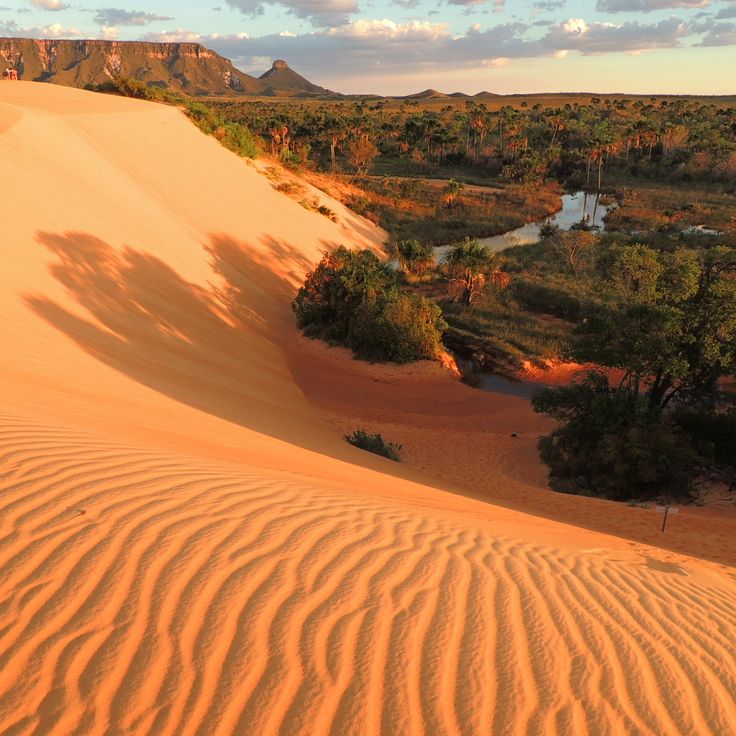
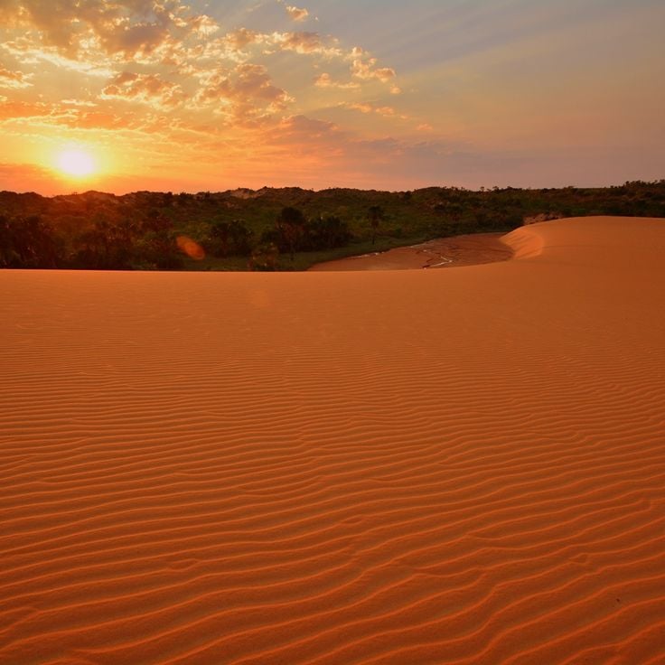
These shifting dunes of fine golden sand rise in the landscape of Mateiros, changing shape with every gust of wind. The dunes form an unusual contrast to the green forests and savannas of the region and invite barefoot walking. At sunrise and sunset, the sand hills glow in warm tones. Visitors can climb the soft slopes and look out over the wide open countryside.
This park sits where rainforest meets savannah. The area holds around 800 lakes formed by rivers and flooding. Visitors walking here may see otters, monkeys and water birds that live among the overgrown banks. The landscape shifts between thick greenery and open ground, depending on whether water levels rise or fall.
This mountain ridge in the Jalapão region provides a lookout point for sunrises over the wide savanna landscape. Hiking trails lead through grasslands and rocky sections to summits with views of neighboring plateaus and river courses. The Serra do Espírito Santo sits within a protected area featuring dry forests and open spaces typical of the Cerrado. Visitors reach the trailhead via unpaved roads and start early in the morning to see the light at daybreak.
This church from the 18th century shows Dutch building features in an old mining town in the interior. The white lime plaster and green wooden doors give the front a simple appearance. Inside there are colonial altars and statues of saints. The community continues to use the building for services and religious celebrations throughout the year.
This canyon lies within the cerrado vegetation near Ponte Alta do Tocantins and fits into the natural protected areas of northern Brazil. The walls rise above the river and form narrow passages between rock formations. Visitors reach the site only with local guides through marked paths across the savanna. Water flows through deep cuts in the stone and shapes pools at the bottom of the canyon.
This park protects a large savanna with sand dunes, waterfalls and natural springs. The region shows the variety of northern Brazil's natural areas with its original vegetation and the landscape forms of the Cerrado, which differ clearly from the rainforest.
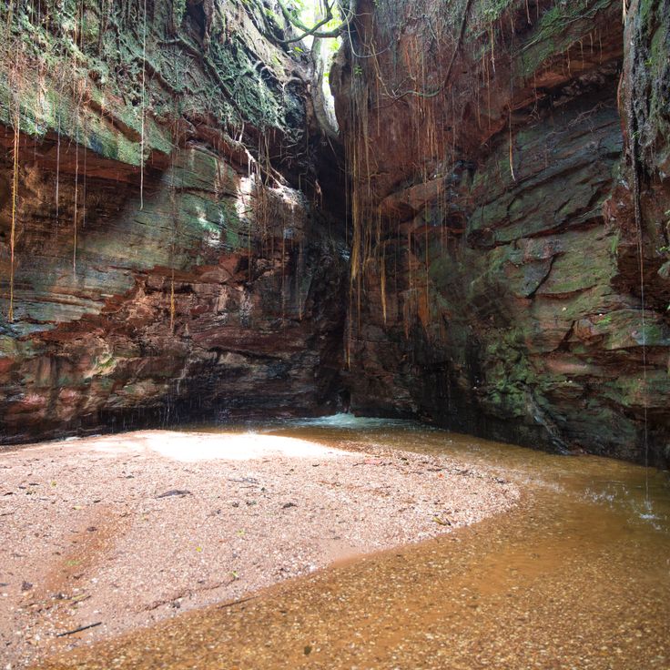
This cave winds through the rainforest near Presidente Figueiredo and opens into several chambers. Water has shaped the limestone over thousands of years, creating underground streams that flow through the darkness. Stalactites hang from the ceiling while stalagmites rise from the floor. Bat colonies inhabit the inner sections, where light and sounds from outside barely reach. The path through the cave passes narrow passages and wider halls where the sound of dripping water echoes. The damp air and cool temperature contrast sharply with the tropical climate outside.
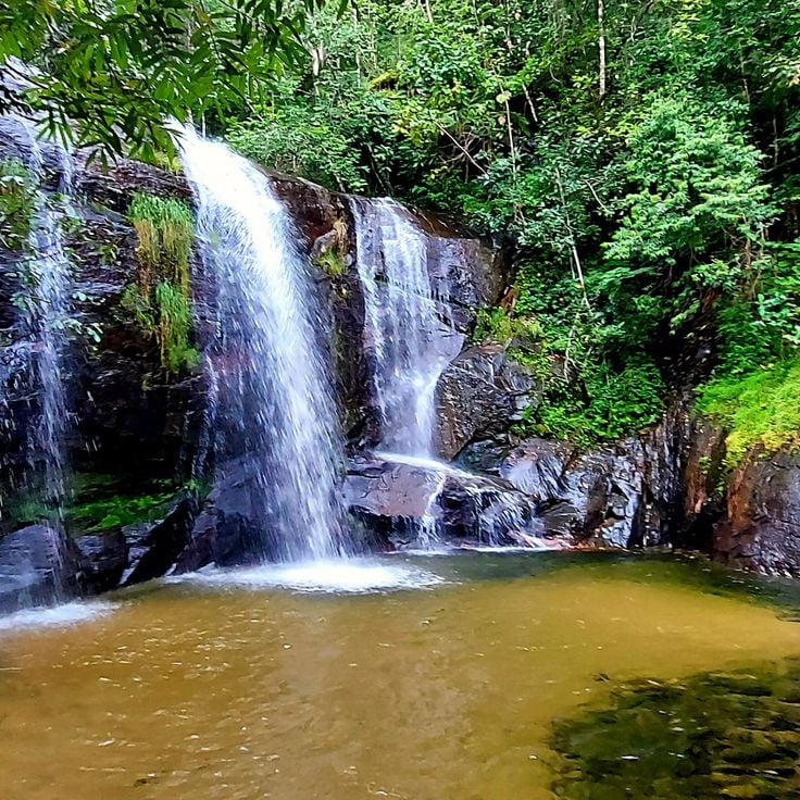
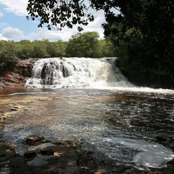
This waterfall drops over granite rocks and forms natural pools in the forest of Tocantins. Visitors reach Cachoeira do Lajeado on paths through the region and find clear water among the stones where people can cool off.
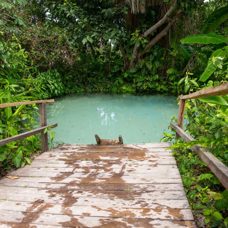
This natural water basin in the Amazon region has a spring at the bottom that colors the water blue and keeps swimmers floating on the surface. Fervedouro do Soninho sits in an area with many natural pools fed by underground water. The water pushes up from below and creates buoyancy that supports people. The temperature stays cool and constant throughout the year. Local guides explain to visitors how to move in the water and avoid damaging the spring.
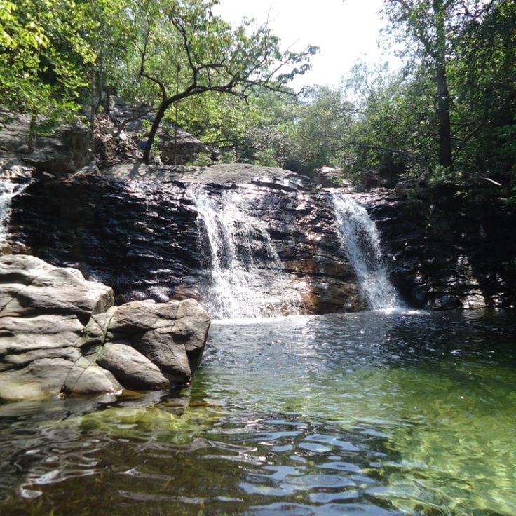
This waterfall drops in several stages and forms natural pools with clear water at its base. Parrots and monkeys move through the trees surrounding the wet rocks. Access follows a path through the forest where the sound of falling water can be heard from a distance. The pools invite swimming while toucans fly between the branches of palm trees.
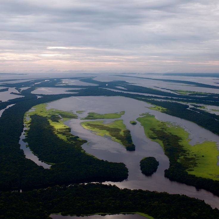
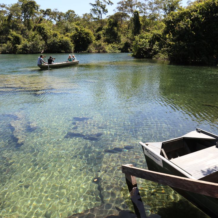
This national park extends across a water landscape of dark rivers and dense forests, where hundreds of islands scatter between the arms of the Rio Negro. Pink river dolphins surface among the roots of mangrove forests, while monkeys and birds move through the canopy. Visitors reach the flooded forests by boat and see orchids growing on submerged trees, along with turtles basking on logs.
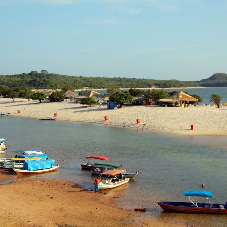
This village on the Tapajós River lies in the Amazon region and combines beaches with natural surroundings. Alter do Chão has white sand beaches along the green water of the river. The Ilha do Amor appears during the dry season as a sandbank between the river and a lagoon. Fishermen live in wooden houses by the shore and traditional boats move through the water. The place belongs to the natural areas of northern Brazil with forests and rivers of the region.
This viewpoint sits at 500 meters elevation and overlooks the surrounding mountain range. From here you see waterfalls cutting through forested slopes and valleys extending into the distance. The position offers a wide view across the landscape with its varying shades of green and rock formations. The site is among the natural attractions in northern Brazil, where visitors find views over the Amazon region and its protected areas. You reach the spot through trails that wind through the vegetation. The area remains quiet and receives few visitors.
This ecological station protects more than 700,000 hectares of cerrado, a savanna landscape with flat plateaus and occasional table mountains. Visitors see palms, gallery forests along small streams and open grasslands. The region lies far from urban centers and preserves rare plants and wildlife of the cerrado. Walking trails lead through different vegetation zones where tapirs and anteaters live. Conservationists work here on research projects about biodiversity.
This national park sits in the Amazon rainforest and protects tropical forest with animals like jaguars, monkeys and tapirs. The park preserves dense vegetation along the Tapajós River and its tributaries. Visitors find a natural setting with trees, waterways and wilderness. Indigenous communities live in the surrounding area and know the local trails and plants.
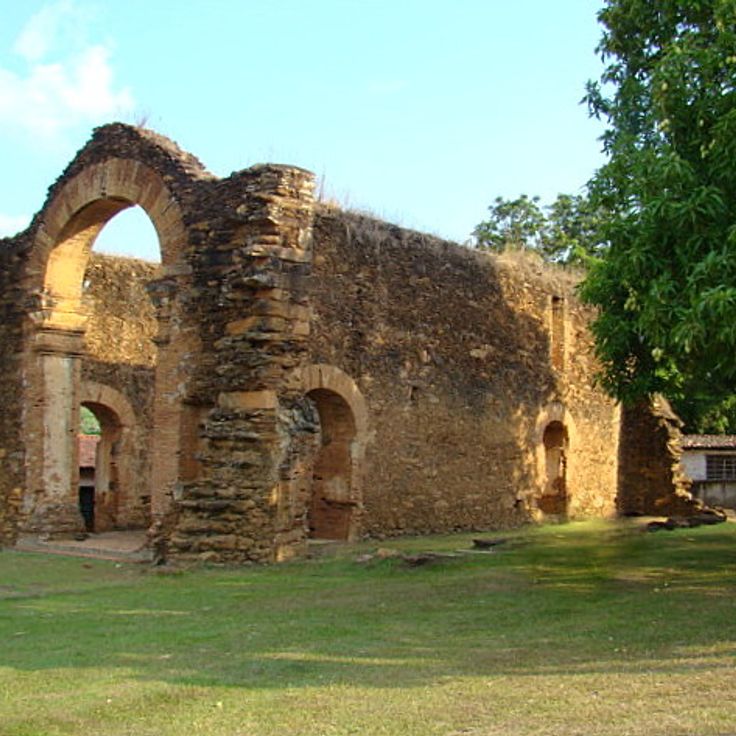
This fortress stands on the bank of the Guaporé River since the 18th century. The Portuguese crown built it to secure the frontier, and thick stone walls surround a wide inner courtyard. From the ramparts you see the river and the dense rainforest around. Today Fort Prince of Beira lies far from usual routes, and only a few travelers reach this place. The structure recalls the time when colonial powers competed for territory in the Amazon region. Those who come here find decaying buildings and vegetation growing through cracks.
This reserve sits at the edge of the Amazon forest and protects an area where families have lived for generations. The residents collect Brazil nuts, fish in the river, and grow small plots for vegetables and cassava. Boats connect the villages with nearby markets. The forest stretches down to the riverbanks, and birds fly between the trees. In the morning you hear monkeys calling in the canopy. People maintain their own trails through the woods and respect the cycles of nature.
This park covers several vegetation zones with savanna and forest. Many native animal species live in this area, which belongs to the protected natural areas in northern Brazil. The landscape shifts between open grassland and wooded sections, where visitors can observe the plant life and wildlife of the region.
This waterfall drops over a wide rock edge. Water splits into two main branches and falls from about 100 meters. Cachoeira da Velha sits in tropical savanna landscape that belongs to Jalapão. Rocks frame the basin, and palm trees grow along the banks. Visitors reach the site on unpaved roads through open terrain with low trees and grasses. At the base of the falls, water gathers in a shallow pool. The current is gentle enough for wading in many spots.
This spring bubbles up through layers of sand and creates a natural buoyancy that keeps visitors floating on the surface. The water of Fervedouro do Ceiça rises continuously from below, making it physically impossible to sink. The spring sits in a remote area of the Jalapão region and belongs to the geological features of northern Brazil, where groundwater pushes upward through porous rock formations.
This natural rock arch rises in the Tocantins landscape. The large opening in the middle formed through wind and rain over long periods. Walking trails lead to Pedra Furada, where visitors can view the rock formation up close. The site lies in a region with other geological features and works well for trips into northern Brazil's natural areas.
This canyon forms a valley with rock walls rising about 100 meters (330 feet), while at the bottom a mountain stream flows through the narrow gorge and makes the reddish stone glow in different shades, shaped by erosion over a long period, and visitors can hike along the watercourse and discover pools that have formed between the rocks.
This river island sits in the Araguaia River and is one of the largest inland islands in the world. It stretches across wide floodplains, marshes and gallery forests that change with the seasons. The island is home to several indigenous communities who have lived with the river cycles for centuries. Over five hundred bird species have been recorded here, including herons, storks and macaws. During the dry season, sandy beaches appear along the riverbanks, while the rainy season floods large parts of the landscape. Ilha do Bananal belongs to Araguaia National Park and connects Amazon and Cerrado ecosystems. Visitors can take canoe trips, watch birds and learn about local cultures that maintain their traditional ways of life.
This waterfall in northern Brazil drops about a hundred feet into a natural pool below. The surrounding forest belongs to a region with little development and few visitors. Travelers reach the site by unpaved roads that cross dry vegetation, and they can swim in the cool water of the basin.
Serra das Andorinhas is a large nature reserve in the Brazilian Amazon with rainforests, rock formations and waterfalls. This region is home to many bird species and other animals. Visitors can follow trails through dense forest and discover caves with prehistoric paintings that show evidence of ancient cultures.
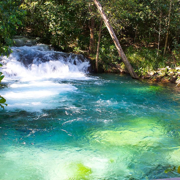
This waterfall drops into a natural basin with turquoise water in Jalapão State Park. The water gets its color from minerals in the rock and flows from a spring nearby. Visitors swim in the clear, cool water. The waterfall is about an hour's walk from the access road and is among the natural formations in this part of northern Brazil.
This river shows blue water for about 147 meters (482 feet), clear enough to see the bottom. Rio Azuis sits in an area with tropical climate, where natural filtration creates the transparent flow. The river forms a narrow corridor between green vegetation, and visitors can walk along the banks and enter the water. The temperature stays consistently cool throughout the year. This site belongs to the natural areas in northern Brazil that remain away from regular tourist routes.
This natural water basin in the remote Chapada das Mesas region forms where spring water pushes upward through sandy ground. The water flows continuously from below, creating enough force to keep people floating on the surface without sinking. Fervedouro Bela Vista sits among cerrado vegetation and palm trees in an area accessible by unpaved roads. The upward pressure makes swimmers stay afloat, an effect of the constant flow from underground springs. Visitor groups arrive to experience the floating sensation, and local communities manage the site and guide access to the basin.
These shifting dunes of fine golden sand rise in the landscape of Mateiros, changing shape with every gust of wind. The dunes form an unusual contrast to the green forests and savannas of the region and invite barefoot walking. At sunrise and sunset, the sand hills glow in warm tones. Visitors can climb the soft slopes and look out over the wide open countryside.
This park sits where rainforest meets savannah. The area holds around 800 lakes formed by rivers and flooding. Visitors walking here may see otters, monkeys and water birds that live among the overgrown banks. The landscape shifts between thick greenery and open ground, depending on whether water levels rise or fall.
This mountain ridge in the Jalapão region provides a lookout point for sunrises over the wide savanna landscape. Hiking trails lead through grasslands and rocky sections to summits with views of neighboring plateaus and river courses. The Serra do Espírito Santo sits within a protected area featuring dry forests and open spaces typical of the Cerrado. Visitors reach the trailhead via unpaved roads and start early in the morning to see the light at daybreak.
This church from the 18th century shows Dutch building features in an old mining town in the interior. The white lime plaster and green wooden doors give the front a simple appearance. Inside there are colonial altars and statues of saints. The community continues to use the building for services and religious celebrations throughout the year.
This canyon lies within the cerrado vegetation near Ponte Alta do Tocantins and fits into the natural protected areas of northern Brazil. The walls rise above the river and form narrow passages between rock formations. Visitors reach the site only with local guides through marked paths across the savanna. Water flows through deep cuts in the stone and shapes pools at the bottom of the canyon.
This park protects a large savanna with sand dunes, waterfalls and natural springs. The region shows the variety of northern Brazil's natural areas with its original vegetation and the landscape forms of the Cerrado, which differ clearly from the rainforest.
This cave winds through the rainforest near Presidente Figueiredo and opens into several chambers. Water has shaped the limestone over thousands of years, creating underground streams that flow through the darkness. Stalactites hang from the ceiling while stalagmites rise from the floor. Bat colonies inhabit the inner sections, where light and sounds from outside barely reach. The path through the cave passes narrow passages and wider halls where the sound of dripping water echoes. The damp air and cool temperature contrast sharply with the tropical climate outside.
This waterfall drops over granite rocks and forms natural pools in the forest of Tocantins. Visitors reach Cachoeira do Lajeado on paths through the region and find clear water among the stones where people can cool off.
This natural water basin in the Amazon region has a spring at the bottom that colors the water blue and keeps swimmers floating on the surface. Fervedouro do Soninho sits in an area with many natural pools fed by underground water. The water pushes up from below and creates buoyancy that supports people. The temperature stays cool and constant throughout the year. Local guides explain to visitors how to move in the water and avoid damaging the spring.
This waterfall drops in several stages and forms natural pools with clear water at its base. Parrots and monkeys move through the trees surrounding the wet rocks. Access follows a path through the forest where the sound of falling water can be heard from a distance. The pools invite swimming while toucans fly between the branches of palm trees.
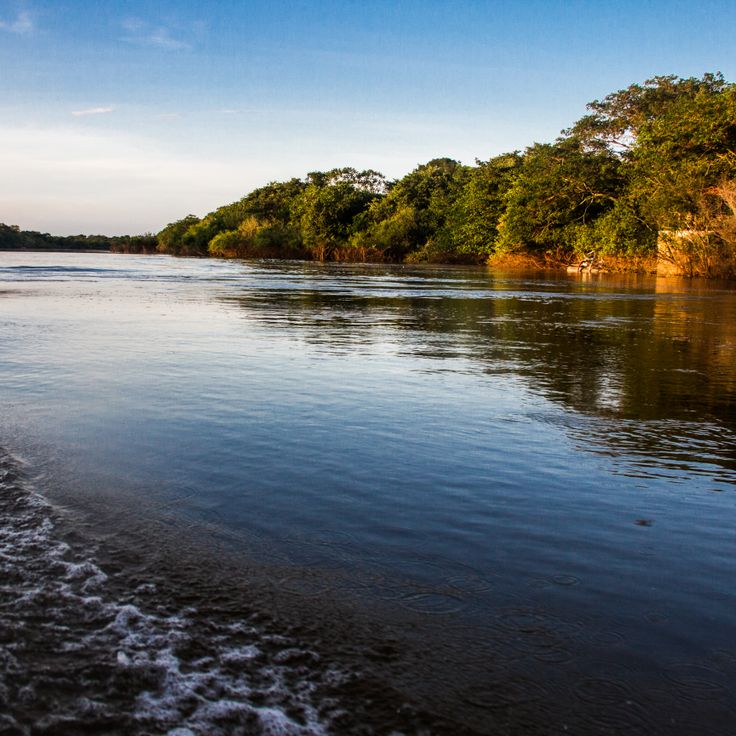
This national park extends across a water landscape of dark rivers and dense forests, where hundreds of islands scatter between the arms of the Rio Negro. Pink river dolphins surface among the roots of mangrove forests, while monkeys and birds move through the canopy. Visitors reach the flooded forests by boat and see orchids growing on submerged trees, along with turtles basking on logs.
This village on the Tapajós River lies in the Amazon region and combines beaches with natural surroundings. Alter do Chão has white sand beaches along the green water of the river. The Ilha do Amor appears during the dry season as a sandbank between the river and a lagoon. Fishermen live in wooden houses by the shore and traditional boats move through the water. The place belongs to the natural areas of northern Brazil with forests and rivers of the region.
This viewpoint sits at 500 meters elevation and overlooks the surrounding mountain range. From here you see waterfalls cutting through forested slopes and valleys extending into the distance. The position offers a wide view across the landscape with its varying shades of green and rock formations. The site is among the natural attractions in northern Brazil, where visitors find views over the Amazon region and its protected areas. You reach the spot through trails that wind through the vegetation. The area remains quiet and receives few visitors.
This ecological station protects more than 700,000 hectares of cerrado, a savanna landscape with flat plateaus and occasional table mountains. Visitors see palms, gallery forests along small streams and open grasslands. The region lies far from urban centers and preserves rare plants and wildlife of the cerrado. Walking trails lead through different vegetation zones where tapirs and anteaters live. Conservationists work here on research projects about biodiversity.
This national park sits in the Amazon rainforest and protects tropical forest with animals like jaguars, monkeys and tapirs. The park preserves dense vegetation along the Tapajós River and its tributaries. Visitors find a natural setting with trees, waterways and wilderness. Indigenous communities live in the surrounding area and know the local trails and plants.
This fortress stands on the bank of the Guaporé River since the 18th century. The Portuguese crown built it to secure the frontier, and thick stone walls surround a wide inner courtyard. From the ramparts you see the river and the dense rainforest around. Today Fort Prince of Beira lies far from usual routes, and only a few travelers reach this place. The structure recalls the time when colonial powers competed for territory in the Amazon region. Those who come here find decaying buildings and vegetation growing through cracks.
This reserve sits at the edge of the Amazon forest and protects an area where families have lived for generations. The residents collect Brazil nuts, fish in the river, and grow small plots for vegetables and cassava. Boats connect the villages with nearby markets. The forest stretches down to the riverbanks, and birds fly between the trees. In the morning you hear monkeys calling in the canopy. People maintain their own trails through the woods and respect the cycles of nature.
This park covers several vegetation zones with savanna and forest. Many native animal species live in this area, which belongs to the protected natural areas in northern Brazil. The landscape shifts between open grassland and wooded sections, where visitors can observe the plant life and wildlife of the region.
This waterfall drops over a wide rock edge. Water splits into two main branches and falls from about 100 meters. Cachoeira da Velha sits in tropical savanna landscape that belongs to Jalapão. Rocks frame the basin, and palm trees grow along the banks. Visitors reach the site on unpaved roads through open terrain with low trees and grasses. At the base of the falls, water gathers in a shallow pool. The current is gentle enough for wading in many spots.
This spring bubbles up through layers of sand and creates a natural buoyancy that keeps visitors floating on the surface. The water of Fervedouro do Ceiça rises continuously from below, making it physically impossible to sink. The spring sits in a remote area of the Jalapão region and belongs to the geological features of northern Brazil, where groundwater pushes upward through porous rock formations.
This natural rock arch rises in the Tocantins landscape. The large opening in the middle formed through wind and rain over long periods. Walking trails lead to Pedra Furada, where visitors can view the rock formation up close. The site lies in a region with other geological features and works well for trips into northern Brazil's natural areas.
This canyon forms a valley with rock walls rising about 100 meters (330 feet), while at the bottom a mountain stream flows through the narrow gorge and makes the reddish stone glow in different shades, shaped by erosion over a long period, and visitors can hike along the watercourse and discover pools that have formed between the rocks.
This river island sits in the Araguaia River and is one of the largest inland islands in the world. It stretches across wide floodplains, marshes and gallery forests that change with the seasons. The island is home to several indigenous communities who have lived with the river cycles for centuries. Over five hundred bird species have been recorded here, including herons, storks and macaws. During the dry season, sandy beaches appear along the riverbanks, while the rainy season floods large parts of the landscape. Ilha do Bananal belongs to Araguaia National Park and connects Amazon and Cerrado ecosystems. Visitors can take canoe trips, watch birds and learn about local cultures that maintain their traditional ways of life.
This waterfall in northern Brazil drops about a hundred feet into a natural pool below. The surrounding forest belongs to a region with little development and few visitors. Travelers reach the site by unpaved roads that cross dry vegetation, and they can swim in the cool water of the basin.
Serra das Andorinhas is a large nature reserve in the Brazilian Amazon with rainforests, rock formations and waterfalls. This region is home to many bird species and other animals. Visitors can follow trails through dense forest and discover caves with prehistoric paintings that show evidence of ancient cultures.
This waterfall drops into a natural basin with turquoise water in Jalapão State Park. The water gets its color from minerals in the rock and flows from a spring nearby. Visitors swim in the clear, cool water. The waterfall is about an hour's walk from the access road and is among the natural formations in this part of northern Brazil.
This river shows blue water for about 147 meters (482 feet), clear enough to see the bottom. Rio Azuis sits in an area with tropical climate, where natural filtration creates the transparent flow. The river forms a narrow corridor between green vegetation, and visitors can walk along the banks and enter the water. The temperature stays consistently cool throughout the year. This site belongs to the natural areas in northern Brazil that remain away from regular tourist routes.
This natural water basin in the remote Chapada das Mesas region forms where spring water pushes upward through sandy ground. The water flows continuously from below, creating enough force to keep people floating on the surface without sinking. Fervedouro Bela Vista sits among cerrado vegetation and palm trees in an area accessible by unpaved roads. The upward pressure makes swimmers stay afloat, an effect of the constant flow from underground springs. Visitor groups arrive to experience the floating sensation, and local communities manage the site and guide access to the basin.
These shifting dunes of fine golden sand rise in the landscape of Mateiros, changing shape with every gust of wind. The dunes form an unusual contrast to the green forests and savannas of the region and invite barefoot walking. At sunrise and sunset, the sand hills glow in warm tones. Visitors can climb the soft slopes and look out over the wide open countryside.
This park sits where rainforest meets savannah. The area holds around 800 lakes formed by rivers and flooding. Visitors walking here may see otters, monkeys and water birds that live among the overgrown banks. The landscape shifts between thick greenery and open ground, depending on whether water levels rise or fall.
This mountain ridge in the Jalapão region provides a lookout point for sunrises over the wide savanna landscape. Hiking trails lead through grasslands and rocky sections to summits with views of neighboring plateaus and river courses. The Serra do Espírito Santo sits within a protected area featuring dry forests and open spaces typical of the Cerrado. Visitors reach the trailhead via unpaved roads and start early in the morning to see the light at daybreak.
This church from the 18th century shows Dutch building features in an old mining town in the interior. The white lime plaster and green wooden doors give the front a simple appearance. Inside there are colonial altars and statues of saints. The community continues to use the building for services and religious celebrations throughout the year.
This canyon lies within the cerrado vegetation near Ponte Alta do Tocantins and fits into the natural protected areas of northern Brazil. The walls rise above the river and form narrow passages between rock formations. Visitors reach the site only with local guides through marked paths across the savanna. Water flows through deep cuts in the stone and shapes pools at the bottom of the canyon.
This park protects a large savanna with sand dunes, waterfalls and natural springs. The region shows the variety of northern Brazil's natural areas with its original vegetation and the landscape forms of the Cerrado, which differ clearly from the rainforest.
This cave winds through the rainforest near Presidente Figueiredo and opens into several chambers. Water has shaped the limestone over thousands of years, creating underground streams that flow through the darkness. Stalactites hang from the ceiling while stalagmites rise from the floor. Bat colonies inhabit the inner sections, where light and sounds from outside barely reach. The path through the cave passes narrow passages and wider halls where the sound of dripping water echoes. The damp air and cool temperature contrast sharply with the tropical climate outside.
This waterfall drops over granite rocks and forms natural pools in the forest of Tocantins. Visitors reach Cachoeira do Lajeado on paths through the region and find clear water among the stones where people can cool off.
This natural water basin in the Amazon region has a spring at the bottom that colors the water blue and keeps swimmers floating on the surface. Fervedouro do Soninho sits in an area with many natural pools fed by underground water. The water pushes up from below and creates buoyancy that supports people. The temperature stays cool and constant throughout the year. Local guides explain to visitors how to move in the water and avoid damaging the spring.
This waterfall drops in several stages and forms natural pools with clear water at its base. Parrots and monkeys move through the trees surrounding the wet rocks. Access follows a path through the forest where the sound of falling water can be heard from a distance. The pools invite swimming while toucans fly between the branches of palm trees.
This national park extends across a water landscape of dark rivers and dense forests, where hundreds of islands scatter between the arms of the Rio Negro. Pink river dolphins surface among the roots of mangrove forests, while monkeys and birds move through the canopy. Visitors reach the flooded forests by boat and see orchids growing on submerged trees, along with turtles basking on logs.
This village on the Tapajós River lies in the Amazon region and combines beaches with natural surroundings. Alter do Chão has white sand beaches along the green water of the river. The Ilha do Amor appears during the dry season as a sandbank between the river and a lagoon. Fishermen live in wooden houses by the shore and traditional boats move through the water. The place belongs to the natural areas of northern Brazil with forests and rivers of the region.
This viewpoint sits at 500 meters elevation and overlooks the surrounding mountain range. From here you see waterfalls cutting through forested slopes and valleys extending into the distance. The position offers a wide view across the landscape with its varying shades of green and rock formations. The site is among the natural attractions in northern Brazil, where visitors find views over the Amazon region and its protected areas. You reach the spot through trails that wind through the vegetation. The area remains quiet and receives few visitors.
This ecological station protects more than 700,000 hectares of cerrado, a savanna landscape with flat plateaus and occasional table mountains. Visitors see palms, gallery forests along small streams and open grasslands. The region lies far from urban centers and preserves rare plants and wildlife of the cerrado. Walking trails lead through different vegetation zones where tapirs and anteaters live. Conservationists work here on research projects about biodiversity.
This national park sits in the Amazon rainforest and protects tropical forest with animals like jaguars, monkeys and tapirs. The park preserves dense vegetation along the Tapajós River and its tributaries. Visitors find a natural setting with trees, waterways and wilderness. Indigenous communities live in the surrounding area and know the local trails and plants.
This fortress stands on the bank of the Guaporé River since the 18th century. The Portuguese crown built it to secure the frontier, and thick stone walls surround a wide inner courtyard. From the ramparts you see the river and the dense rainforest around. Today Fort Prince of Beira lies far from usual routes, and only a few travelers reach this place. The structure recalls the time when colonial powers competed for territory in the Amazon region. Those who come here find decaying buildings and vegetation growing through cracks.
This reserve sits at the edge of the Amazon forest and protects an area where families have lived for generations. The residents collect Brazil nuts, fish in the river, and grow small plots for vegetables and cassava. Boats connect the villages with nearby markets. The forest stretches down to the riverbanks, and birds fly between the trees. In the morning you hear monkeys calling in the canopy. People maintain their own trails through the woods and respect the cycles of nature.