See the monuments around you in AROpen chests in the app
Around Us is built for your phone — point your camera at the streets and discover the monuments and places around you in augmented reality.Around Us is built for your phone — chests unlock when you walk, explore and capture nearby places.
Sweden stretches from southern sand beaches to forests and tundra in the north. The country preserves records from several millennia: prehistoric rock carvings, Viking burial sites, medieval fortresses, and 18th century ironworks. The coastline includes limestone cliffs, archipelago islands, and wooden piers at small fishing villages.
This collection takes you to historical places like Gammelstad Church Town, where hundreds of red wooden huts surround a medieval pilgrimage center, or the Stone Ship Monument at Kåseberga, where raised stones form the outline of a Viking ship. It also includes national parks such as Skuleskogen with its spruce forests and steep coasts, ironworks like Engelsberg where charcoal blast furnaces still stand, and museums like the Hallwyl collection in Stockholm. Visitors find island fortresses, peatlands, long-distance trails through arctic regions, and villages that show Swedish life from earlier centuries.
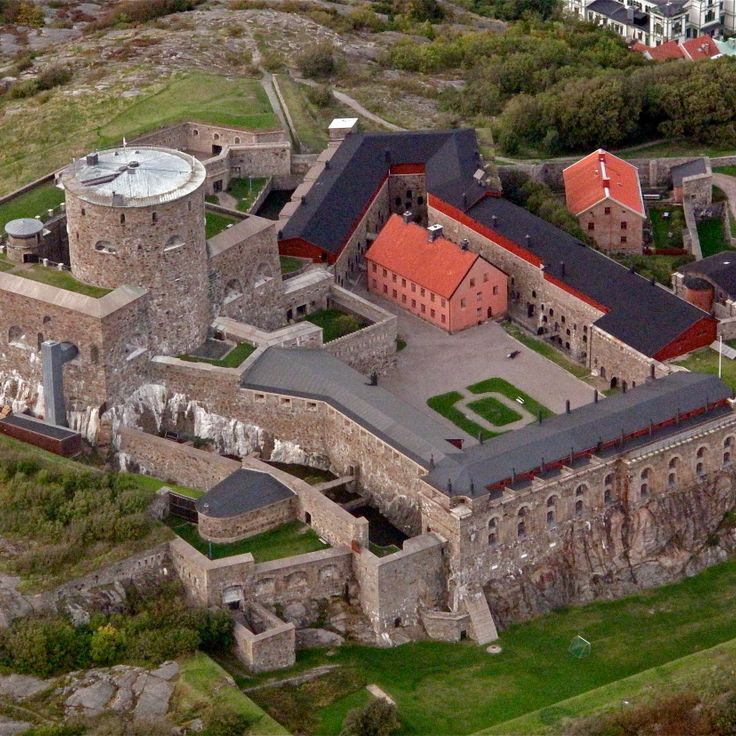
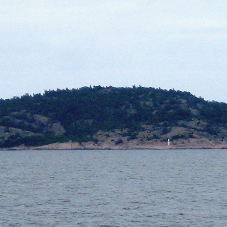
This stone fortification was built in 1658 on an island to control maritime trade. The building houses military exhibitions and historical rooms that tell the story of its strategic role. From the walls, views open across the sea and the surrounding archipelago islands. The fortress sits on a rock above the harbor town and served as a key defensive point along the Swedish west coast for centuries.
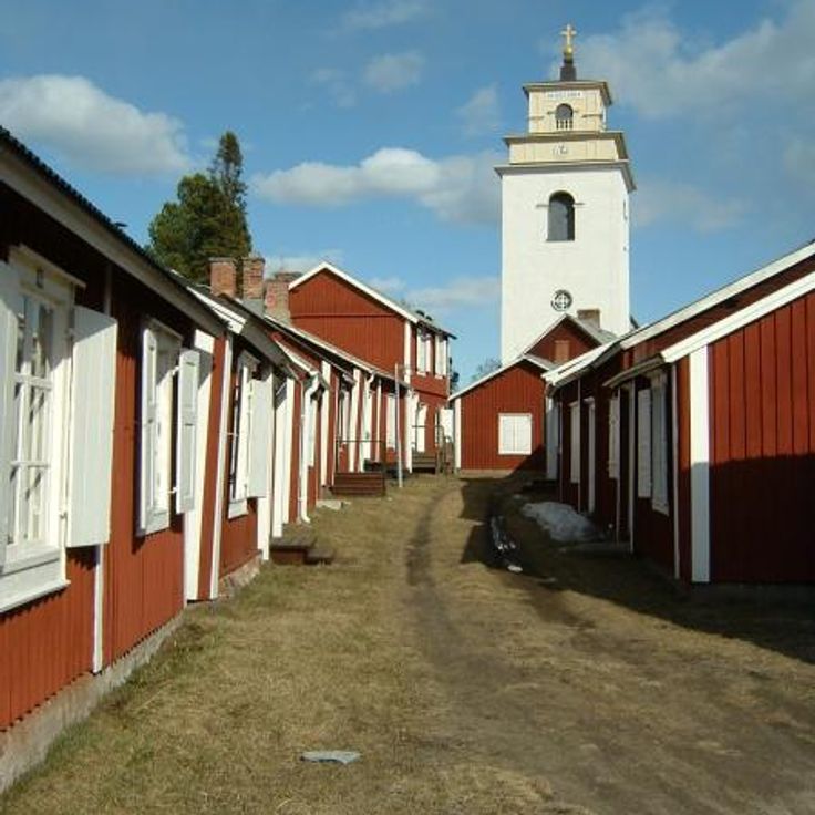
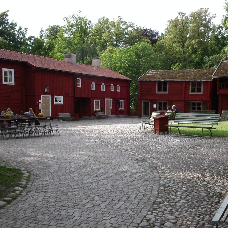
Gammelstad Church Town gathers around a medieval stone church. This settlement in northern Sweden is one of the few remaining church towns in the country. The community preserves 424 red wooden houses from the 15th century, which once served as lodgings for churchgoers. The narrow lanes and small buildings stand close together. Each house belonged to a family who traveled from distant farms to attend mass. The stone church dates from the Middle Ages and still holds services today. On weekends and feast days, visitors arrive to walk through the historic settlement and experience its quiet atmosphere.
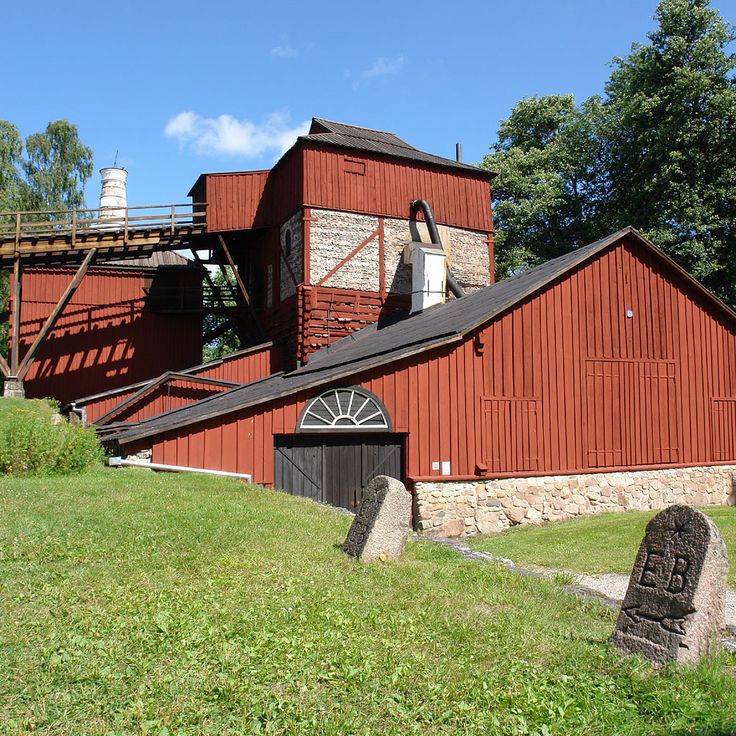
This industrial site from the 18th century shows tools and methods of iron processing. The original buildings and machines remain in place. The facility belongs to Sweden's historical ironworks and offers a view into working life from past centuries. Visitors can walk through workshops and see how metal was once melted and shaped.
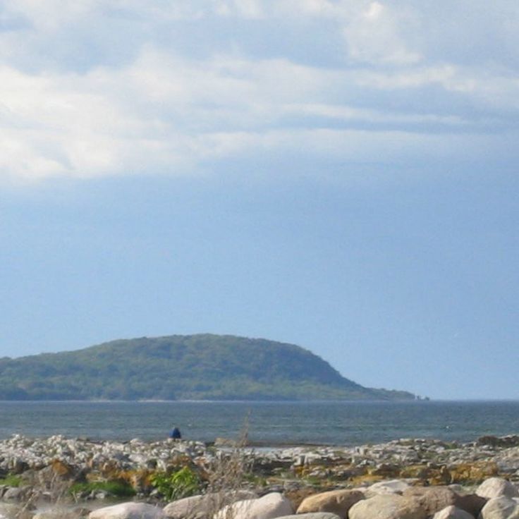
This coastal national park covers 390 hectares near the sea. A granite outcrop rises 97 meters (318 feet) above beaches and deciduous forests. The area offers trails through the woods and views across the water. The rock forms a landmark along this section of the Swedish coast. Visitors find sandy beaches and forested slopes in a natural landscape.
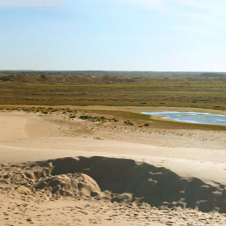
This migrating dune rises to a height of 130 feet (40 meters) and moves about 50 feet (15 meters) northeast each year. Råbjerg Mile covers one square kilometer and ranks among the largest moving dunes in northern Europe. The sand reshapes constantly through wind from the sea. Visitors can climb to the crest and cross the area that sits between the coast and inland terrain.
Ramsviklandet is a nature reserve with granite formations crossed by deep cracks. The rocks carry traces of glaciers from the ice age that moved through this landscape about 10,000 years ago, leaving characteristic lines and grooves carved into the stone.
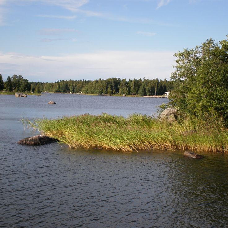
This archipelago lies in the northern Gulf of Bothnia and forms part of a UNESCO World Heritage site. The island landscape emerged after the retreat of the ice age glaciers, when the land began to lift from the weight of the ice. The seabed continues to rise today, causing new islands to appear above the water and existing land masses to grow. Over 5,000 islands create a shifting mosaic of water, rock, and vegetation. Pine trees grow on the younger land, while older areas carry denser forests. During summer, locals use the islands for hiking and boating, and in winter the sea between the land masses freezes over. The light changes strongly with the seasons, from long summer days to short winter afternoons.
This red wooden house from the 18th century stands in Karlstad and once served as a manor estate. The museum now displays a collection of items that belonged to a Swedish poet. The rooms preserve the feeling of a grand country house from the time when Sweden was shaping its literary traditions. Visitors walk through chambers with original furnishings and discover manuscripts, personal belongings and furniture that tell the story of the poet's life and work. Alster's Herrgård sits away from the main routes and offers a window into the country's culture beyond the major cities.
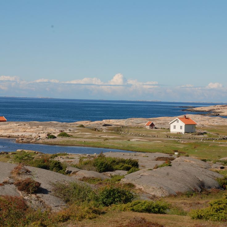
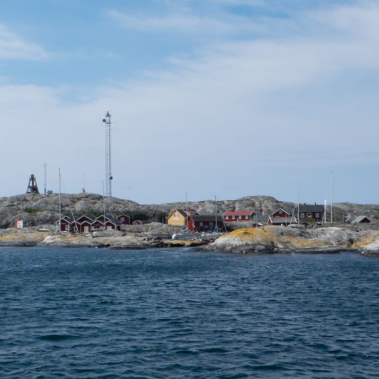
These islands off the west coast form a group of 365 granite formations spread across the sea. The area sits in a part of Sweden where rock and open water shape the view. Seals swim between the islands, and migratory birds pass through in spring and fall. Most islands remain uninhabited, surrounded by water that changes with the weather. Fishermen have known the routes for generations. Visitors can take boats out and experience the quiet that settles here when only wind and waves break the silence.
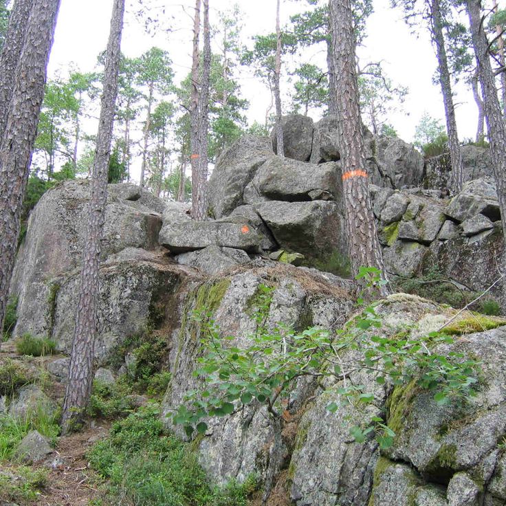
This national park shows granite formations from the ice age between pine and spruce trees. A network of hiking trails crosses the forest. The forest grows on rocky ground shaped by glaciers. Visitors follow marked paths between the trees and over the rocks. The vegetation covers the ground with mosses and ferns, especially in the moist areas under the tree canopies. Tiveden is home to wildlife that lives among the trees. The trails connect different parts of the park and allow for several hours or full-day trips through this woodland area.
This museum displays rock carvings from the Bronze Age on red granite surfaces. The images include boats, people and cattle, documenting daily life from about 3000 years ago. The stones sit outdoors along marked paths. Information panels explain the scenes and their possible meanings. Vitlycke Museum serves as a starting point for visitors wanting to learn about these prehistoric sites in western Sweden.
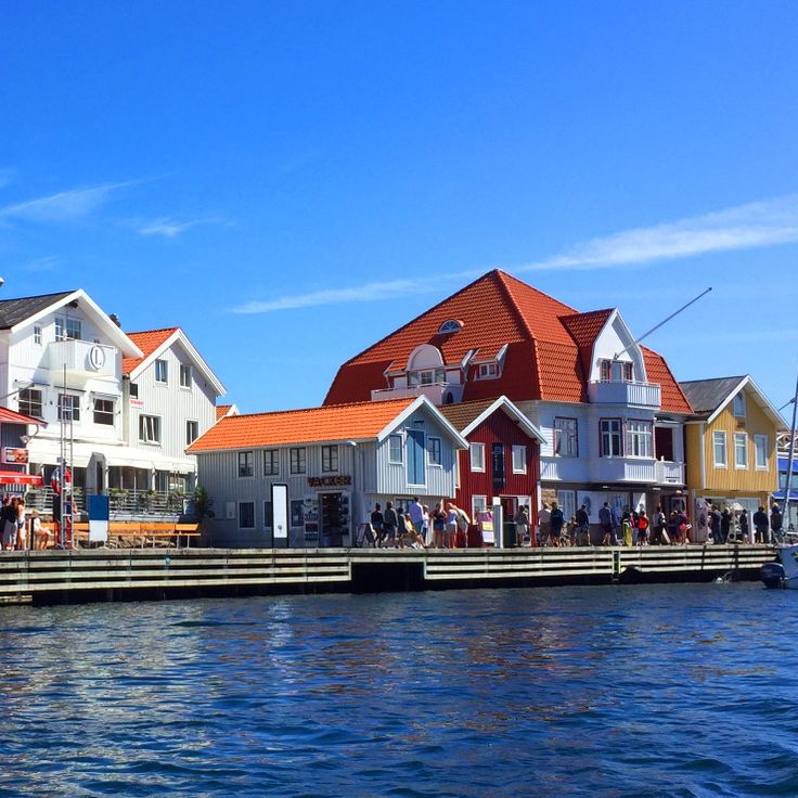
This 600-meter (2,000-foot) harbor promenade connects red fishing houses and boat moorings along the coast. Fishermen sell their catch directly from the boats while visitors walk between the traditional wooden buildings. The setting reflects the maritime heritage of the region, where daily life on the water has continued for generations.
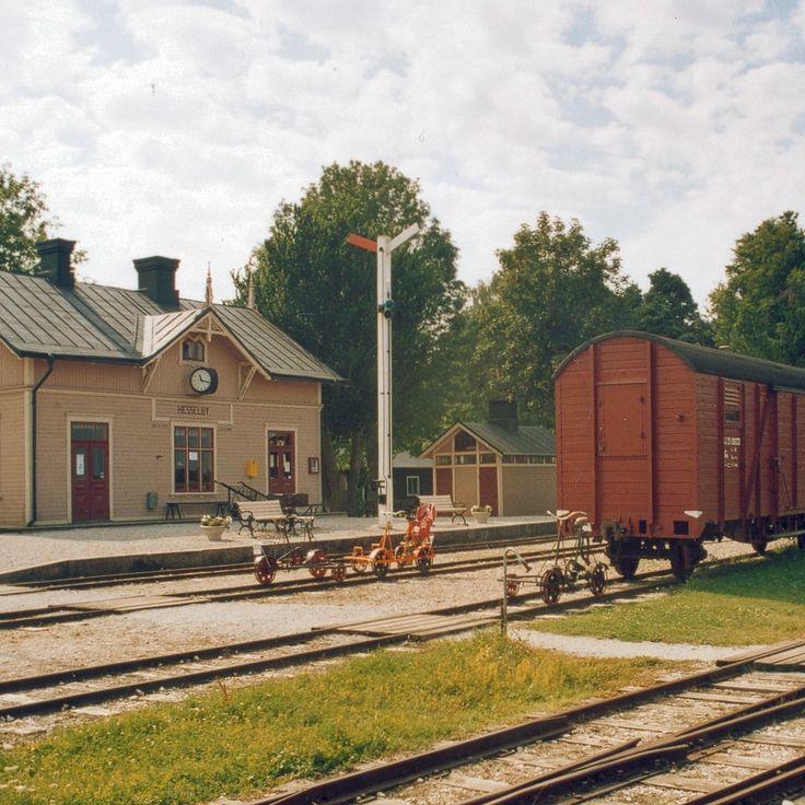
This museum preserves locomotives and railroad cars from the industrialization era on Gotland. The exhibition displays rail vehicles alongside tools for track maintenance. Visitors see technical equipment from past decades of Swedish railway history. The Railway Museum documents transportation and the development of rail infrastructure on the island.
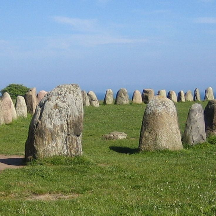
This Iron Age monument consists of 59 stones arranged in the shape of a ship. The formation follows Nordic burial traditions and ranks among the larger preserved stone ships in Sweden. The stones stand on a rise above the Baltic Sea, where wind and weather have shaped their gray surfaces for centuries. Visitors can walk between the stones and view the construction from different angles. On clear days, the sea and surrounding fields stretch out from this point.
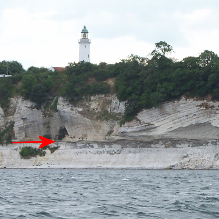
The chalk cliffs in Höllviken are a geological formation that contains fossils from the Cretaceous period. These cliffs stand in southern Sweden and reveal layers documenting changes in marine fauna over millions of years. The white rock faces are among the few visible chalk formations in the country, offering insight into past marine environments when this region lay underwater and was inhabited by sea creatures.
This open-air museum in Örebro brings together historical farmhouses from the region and demonstrates rural life from past centuries. Craftspeople demonstrate old techniques including blacksmithing, weaving and woodworking. The buildings come from different periods and have been rebuilt on this site to preserve Swedish building traditions. Visitors can walk through the farmyards, enter the living rooms and examine the tools of the time.
This national park preserves old traces of iron production amid meadows and forests rich in wildflowers. Visitors follow marked trails through changing landscapes where historic stone walls and clearings recall earlier use. The vegetation shifts between open areas and dense tree cover. In spring, many wildflowers bloom across the meadows, while old building remains tell of iron production from past centuries.
This national park on the eastern coast protects coastal forest on granite bedrock above the Gulf of Bothnia. Skuleskogen covers ridges where pine and spruce grow between moss-covered boulders. Trails lead through woodland to sandy coves and viewpoints over the water. Wildflowers bloom among the trees in spring, while autumn months turn the vegetation red and gold. The park shelters old-growth forest and natural shoreline formations.
This museum in central Kalmar focuses on Nordic and international art across four gallery rooms lit by skylights. The collection covers works from the 16th century to the present, including paintings, sculptures and installations. Changing exhibitions appear at regular intervals alongside the permanent collection. The building dates from the late 20th century and combines functional architecture with natural light filtering through roof windows into the exhibition spaces. The ground floor houses a museum shop and a café.
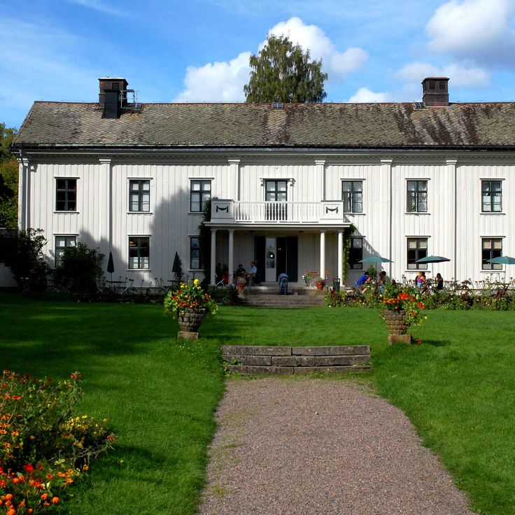
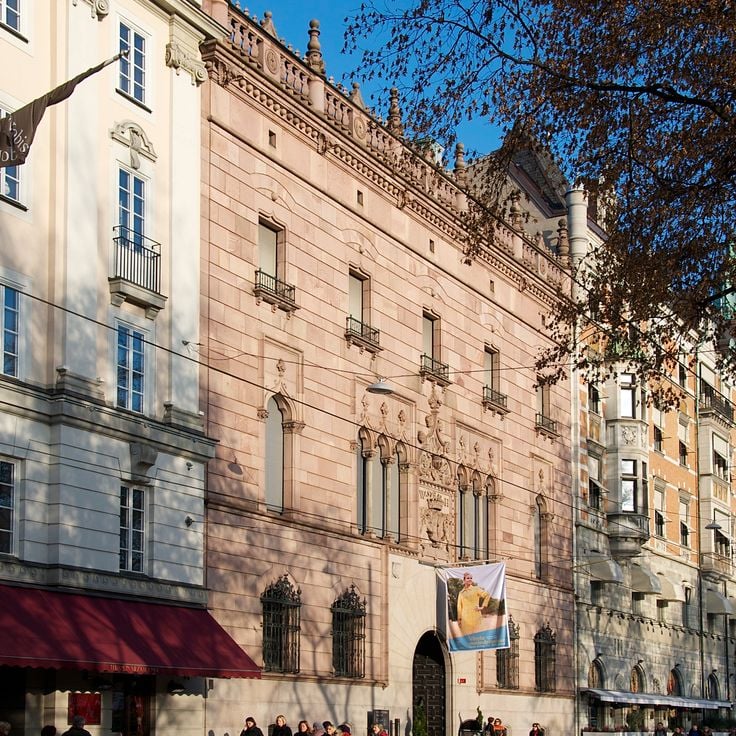
This city palace from 1898 preserves the living quarters of the noble Hallwyl family with their art collection and family library. The rooms show how a Stockholm aristocratic family lived at the turn of the 20th century. Visitors can walk through salons, dining rooms and private chambers furnished with furniture, paintings and objects from different periods.
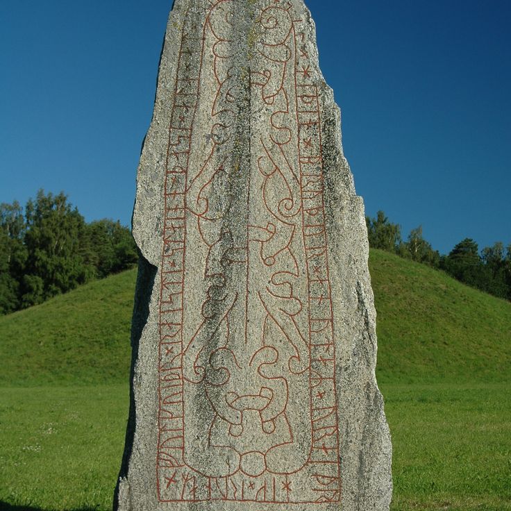
This ninth century burial mound near Västerås ranks among the largest in Sweden. The site rises twelve meters above the surrounding field and holds five stone formations arranged around its base, along with two runestones carved with inscriptions from the Viking age. People in medieval times used this place to honor ancestors and display power. Visitors walk between the stones and grasp the scale of this burial ground, which stands on open land. The site connects to the prehistoric rock carvings and Viking traces found across many parts of the country.
This Baltic Sea island spreads across pine forests and sand dunes. The sand rises in places to about 100 feet (30 meters). A lighthouse from 1859 stands on the grounds and marks the coast for passing ships. The island sits isolated in the open sea, far from larger settlements. Visitors reach Gotska Sandön only by boat. Walking trails lead through the forests and along the dunes. Light filters through the pines onto sandy paths. In summer, beach grass blooms here and there among the dunes.
This island fortress was built in 1308 on a rock above the Nordre Älv River. Bohus Fortress withstood fourteen sieges without falling. The granite defense walls rise above the water, showing medieval military architecture. Visitors walk through the ruins of towers, casemates and living quarters. From the upper levels, views open onto the river and the surrounding landscape. The fortress once served as a strategic border post between Nordic kingdoms and played a central role in regional conflicts.
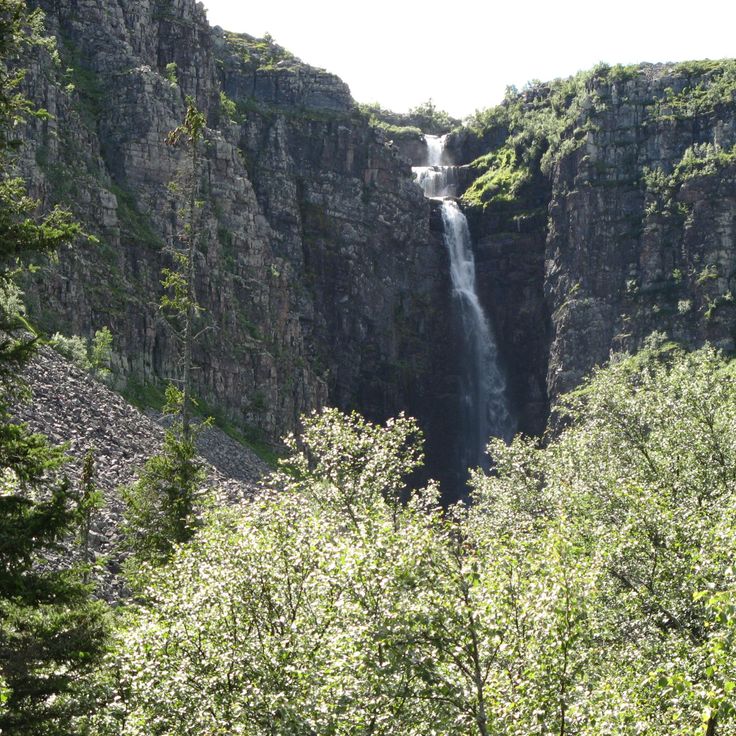
Fulufjället sits near the Norwegian border and protects highlands, forests and open moors. The Njupeskär waterfall drops 93 meters (305 feet) here, making it one of the tallest waterfalls in the country. This park is home to Tjikko, a spruce whose root system dates back roughly 9550 years, ranking among the oldest living trees on Earth. Trails lead through areas where reindeer roam, birch trees grow sparse and plateaus open wide under long summer daylight.
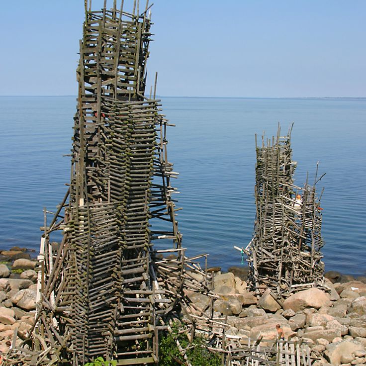
Nimis Artwork stands along the shoreline of Kullaberg and consists of driftwood collected from the beach. The structure reaches 16 meters in height and extends 75 meters along the coast. This wooden work was built without official permission and sits hidden among rocks and vegetation. Visitors reach the site by a steep path that descends from the parking area to the shore. The construction feels organic and blends into the natural surroundings of stone and sea.
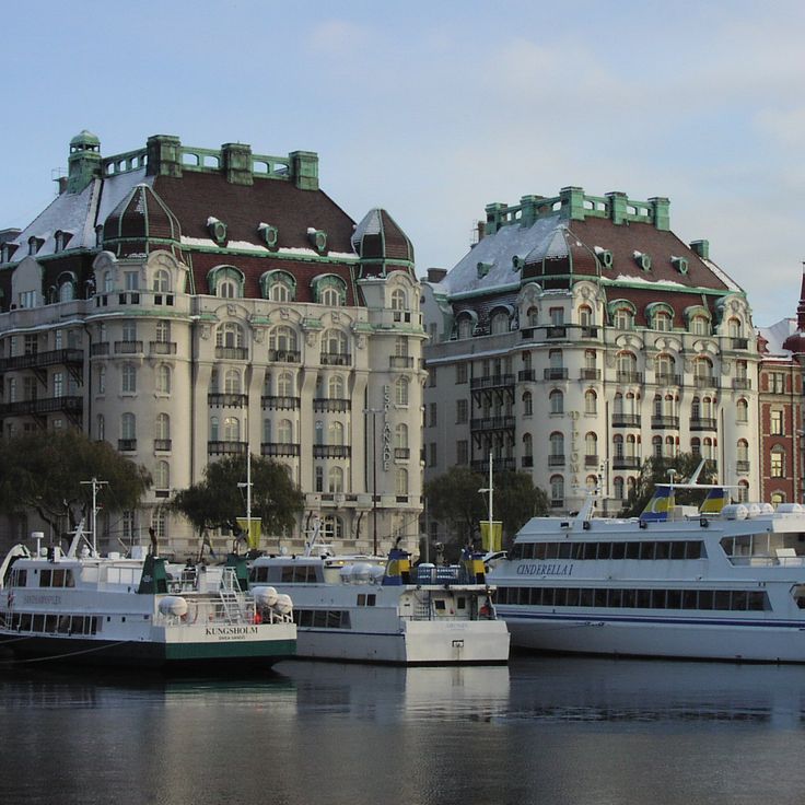
This waterfront promenade runs along the harbor and shows buildings from the late 19th century. Strandvägen connects several city neighborhoods and passes facades in the Art Nouveau style. Boats rest at the quay where locals walk and visit cafés. The street follows the waterline and offers views across to the archipelago islands.
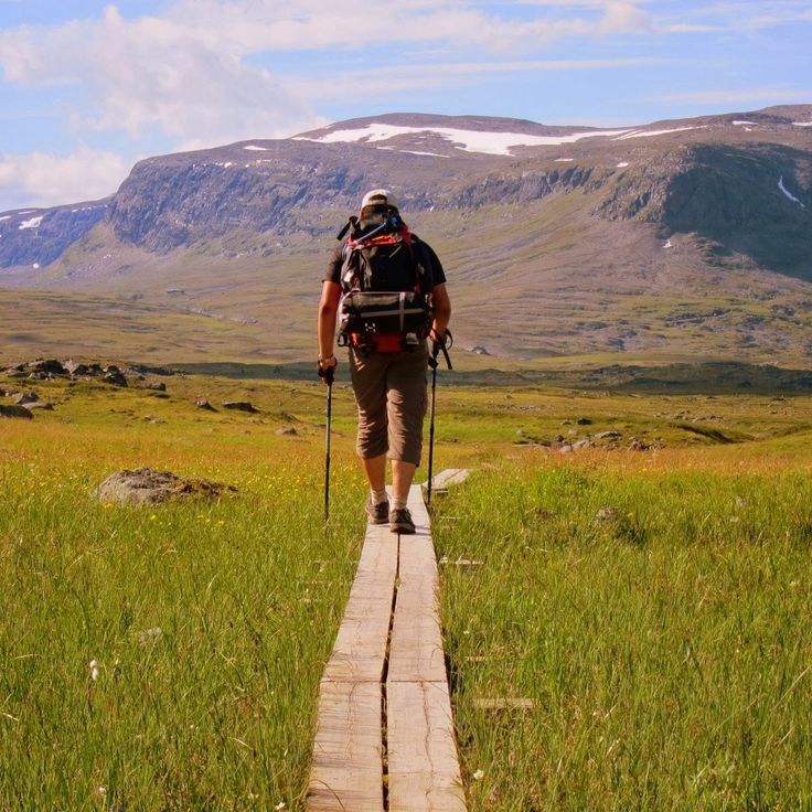
The King's Trail crosses four national parks in Swedish Lapland over a distance of more than 400 kilometers (250 miles). This long-distance footpath passes through birch forests, alpine valleys and high plateaus with glaciers. Hikers encounter reindeer herds and stay overnight in simple huts along the route. The trail connects mountain lakes and rivers in a landscape shaped by the changing seasons.
This national park near Lieksa protects peat bogs, coniferous forests and lakes across more than 100 square kilometers (40 square miles). Visitors follow marked trails through areas where sphagnum moss grows and birds nest. The landscape shows how water and soil interact in boreal zones. In summer, daylight lasts until late; in winter, snow covers the quiet expanses.
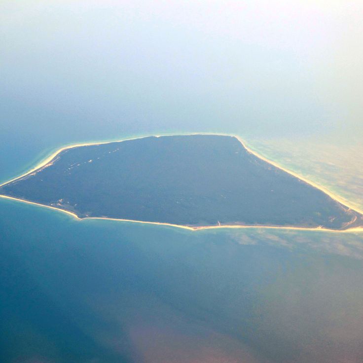
This island rises from the Baltic Sea near Oskarshamn, formed by smooth granite that slopes sharply toward the water. Blå Jungfrun was shaped by glacial movement and shows caves and boulder fields created by wind and weather over centuries. In Nordic myths, the place was considered a gathering spot for witches. Today the island is part of a national park and remains uninhabited.
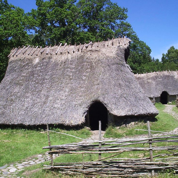
This 5th century fortification is among the best preserved Iron Age defensive sites in Scandinavia. Eketorp Fortress shows a circular layout with reconstructed houses, defense walls and workshops from the period between 400 and 1300 AD. Visitors can walk through the remains of residential buildings and see how people lived in this region during the Migration Period and the Middle Ages. The site sits on the island of Öland and was used and expanded in several phases.
This manor from the 18th century shows classical Swedish architecture with manicured gardens arranged in geometric patterns. The rooms preserve furniture and decoration from the construction period. An orangery stands among the beds. Visitors see how wealthy families lived at the time. The estate sits outside Gothenburg and connects interior spaces with outdoor areas following French design principles.
This wooden pier runs 572 meters into the Baltic Sea and ends at a restaurant. From the walkway you see open water, sailboats crossing the strait and the Danish coast on the horizon. In summer families come to swim, at sunset walkers arrive. The pier was built in the 19th century to dock ferries, today it serves as a viewing point and meeting spot for locals and travelers.
This island sits in the Baltic Sea and preserves a 16th-century observatory built by astronomer Tycho Brahe. The shoreline runs for a modest distance, and visitors can walk or cycle along paths that pass through open fields and small woods. An old lighthouse stands on the coast. The landscape remains flat, and from different points you can see the water all around. The island receives guests by ferry from the nearby harbor of Landskrona.
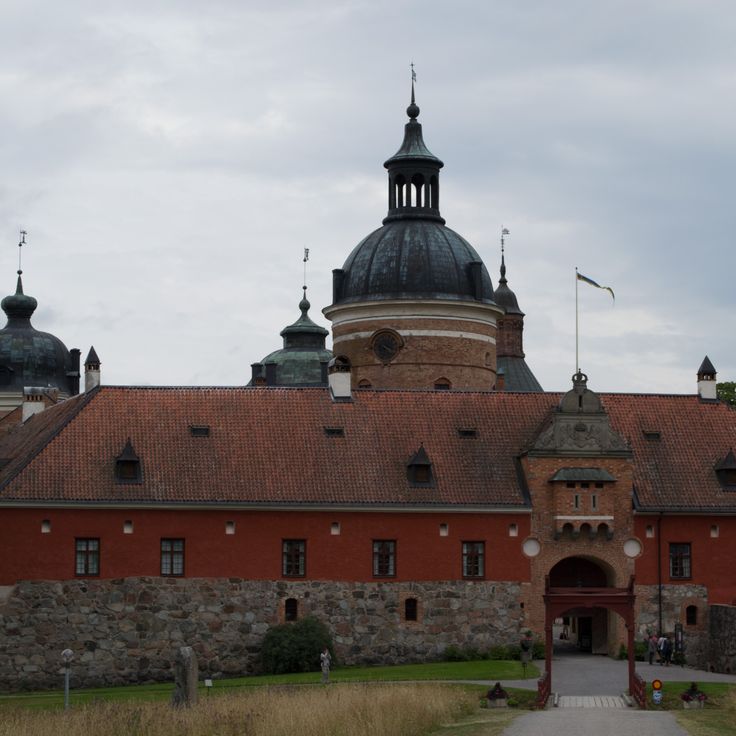
This castle has stood on a small island in Lake Mälaren since the 14th century. The red brick walls and four round towers have shaped the view since the Renaissance. Inside the rooms hang portraits of Swedish personalities from different centuries. The collection includes furniture and furnishings from the 16th century. A tour leads through halls with wooden ceilings, tiled stoves and paintings. The courtyard opens toward the water. From the towers you can see across the lake and the surrounding forests.
This stone fortification was built in 1658 on an island to control maritime trade. The building houses military exhibitions and historical rooms that tell the story of its strategic role. From the walls, views open across the sea and the surrounding archipelago islands. The fortress sits on a rock above the harbor town and served as a key defensive point along the Swedish west coast for centuries.
Gammelstad Church Town gathers around a medieval stone church. This settlement in northern Sweden is one of the few remaining church towns in the country. The community preserves 424 red wooden houses from the 15th century, which once served as lodgings for churchgoers. The narrow lanes and small buildings stand close together. Each house belonged to a family who traveled from distant farms to attend mass. The stone church dates from the Middle Ages and still holds services today. On weekends and feast days, visitors arrive to walk through the historic settlement and experience its quiet atmosphere.
This industrial site from the 18th century shows tools and methods of iron processing. The original buildings and machines remain in place. The facility belongs to Sweden's historical ironworks and offers a view into working life from past centuries. Visitors can walk through workshops and see how metal was once melted and shaped.
This coastal national park covers 390 hectares near the sea. A granite outcrop rises 97 meters (318 feet) above beaches and deciduous forests. The area offers trails through the woods and views across the water. The rock forms a landmark along this section of the Swedish coast. Visitors find sandy beaches and forested slopes in a natural landscape.
This migrating dune rises to a height of 130 feet (40 meters) and moves about 50 feet (15 meters) northeast each year. Råbjerg Mile covers one square kilometer and ranks among the largest moving dunes in northern Europe. The sand reshapes constantly through wind from the sea. Visitors can climb to the crest and cross the area that sits between the coast and inland terrain.
Ramsviklandet is a nature reserve with granite formations crossed by deep cracks. The rocks carry traces of glaciers from the ice age that moved through this landscape about 10,000 years ago, leaving characteristic lines and grooves carved into the stone.
This archipelago lies in the northern Gulf of Bothnia and forms part of a UNESCO World Heritage site. The island landscape emerged after the retreat of the ice age glaciers, when the land began to lift from the weight of the ice. The seabed continues to rise today, causing new islands to appear above the water and existing land masses to grow. Over 5,000 islands create a shifting mosaic of water, rock, and vegetation. Pine trees grow on the younger land, while older areas carry denser forests. During summer, locals use the islands for hiking and boating, and in winter the sea between the land masses freezes over. The light changes strongly with the seasons, from long summer days to short winter afternoons.
This red wooden house from the 18th century stands in Karlstad and once served as a manor estate. The museum now displays a collection of items that belonged to a Swedish poet. The rooms preserve the feeling of a grand country house from the time when Sweden was shaping its literary traditions. Visitors walk through chambers with original furnishings and discover manuscripts, personal belongings and furniture that tell the story of the poet's life and work. Alster's Herrgård sits away from the main routes and offers a window into the country's culture beyond the major cities.
These islands off the west coast form a group of 365 granite formations spread across the sea. The area sits in a part of Sweden where rock and open water shape the view. Seals swim between the islands, and migratory birds pass through in spring and fall. Most islands remain uninhabited, surrounded by water that changes with the weather. Fishermen have known the routes for generations. Visitors can take boats out and experience the quiet that settles here when only wind and waves break the silence.
This national park shows granite formations from the ice age between pine and spruce trees. A network of hiking trails crosses the forest. The forest grows on rocky ground shaped by glaciers. Visitors follow marked paths between the trees and over the rocks. The vegetation covers the ground with mosses and ferns, especially in the moist areas under the tree canopies. Tiveden is home to wildlife that lives among the trees. The trails connect different parts of the park and allow for several hours or full-day trips through this woodland area.
This museum displays rock carvings from the Bronze Age on red granite surfaces. The images include boats, people and cattle, documenting daily life from about 3000 years ago. The stones sit outdoors along marked paths. Information panels explain the scenes and their possible meanings. Vitlycke Museum serves as a starting point for visitors wanting to learn about these prehistoric sites in western Sweden.
This 600-meter (2,000-foot) harbor promenade connects red fishing houses and boat moorings along the coast. Fishermen sell their catch directly from the boats while visitors walk between the traditional wooden buildings. The setting reflects the maritime heritage of the region, where daily life on the water has continued for generations.
This museum preserves locomotives and railroad cars from the industrialization era on Gotland. The exhibition displays rail vehicles alongside tools for track maintenance. Visitors see technical equipment from past decades of Swedish railway history. The Railway Museum documents transportation and the development of rail infrastructure on the island.
This Iron Age monument consists of 59 stones arranged in the shape of a ship. The formation follows Nordic burial traditions and ranks among the larger preserved stone ships in Sweden. The stones stand on a rise above the Baltic Sea, where wind and weather have shaped their gray surfaces for centuries. Visitors can walk between the stones and view the construction from different angles. On clear days, the sea and surrounding fields stretch out from this point.
The chalk cliffs in Höllviken are a geological formation that contains fossils from the Cretaceous period. These cliffs stand in southern Sweden and reveal layers documenting changes in marine fauna over millions of years. The white rock faces are among the few visible chalk formations in the country, offering insight into past marine environments when this region lay underwater and was inhabited by sea creatures.
This open-air museum in Örebro brings together historical farmhouses from the region and demonstrates rural life from past centuries. Craftspeople demonstrate old techniques including blacksmithing, weaving and woodworking. The buildings come from different periods and have been rebuilt on this site to preserve Swedish building traditions. Visitors can walk through the farmyards, enter the living rooms and examine the tools of the time.
This national park preserves old traces of iron production amid meadows and forests rich in wildflowers. Visitors follow marked trails through changing landscapes where historic stone walls and clearings recall earlier use. The vegetation shifts between open areas and dense tree cover. In spring, many wildflowers bloom across the meadows, while old building remains tell of iron production from past centuries.
This national park on the eastern coast protects coastal forest on granite bedrock above the Gulf of Bothnia. Skuleskogen covers ridges where pine and spruce grow between moss-covered boulders. Trails lead through woodland to sandy coves and viewpoints over the water. Wildflowers bloom among the trees in spring, while autumn months turn the vegetation red and gold. The park shelters old-growth forest and natural shoreline formations.
This museum in central Kalmar focuses on Nordic and international art across four gallery rooms lit by skylights. The collection covers works from the 16th century to the present, including paintings, sculptures and installations. Changing exhibitions appear at regular intervals alongside the permanent collection. The building dates from the late 20th century and combines functional architecture with natural light filtering through roof windows into the exhibition spaces. The ground floor houses a museum shop and a café.
This city palace from 1898 preserves the living quarters of the noble Hallwyl family with their art collection and family library. The rooms show how a Stockholm aristocratic family lived at the turn of the 20th century. Visitors can walk through salons, dining rooms and private chambers furnished with furniture, paintings and objects from different periods.
This ninth century burial mound near Västerås ranks among the largest in Sweden. The site rises twelve meters above the surrounding field and holds five stone formations arranged around its base, along with two runestones carved with inscriptions from the Viking age. People in medieval times used this place to honor ancestors and display power. Visitors walk between the stones and grasp the scale of this burial ground, which stands on open land. The site connects to the prehistoric rock carvings and Viking traces found across many parts of the country.
This Baltic Sea island spreads across pine forests and sand dunes. The sand rises in places to about 100 feet (30 meters). A lighthouse from 1859 stands on the grounds and marks the coast for passing ships. The island sits isolated in the open sea, far from larger settlements. Visitors reach Gotska Sandön only by boat. Walking trails lead through the forests and along the dunes. Light filters through the pines onto sandy paths. In summer, beach grass blooms here and there among the dunes.
This island fortress was built in 1308 on a rock above the Nordre Älv River. Bohus Fortress withstood fourteen sieges without falling. The granite defense walls rise above the water, showing medieval military architecture. Visitors walk through the ruins of towers, casemates and living quarters. From the upper levels, views open onto the river and the surrounding landscape. The fortress once served as a strategic border post between Nordic kingdoms and played a central role in regional conflicts.
Fulufjället sits near the Norwegian border and protects highlands, forests and open moors. The Njupeskär waterfall drops 93 meters (305 feet) here, making it one of the tallest waterfalls in the country. This park is home to Tjikko, a spruce whose root system dates back roughly 9550 years, ranking among the oldest living trees on Earth. Trails lead through areas where reindeer roam, birch trees grow sparse and plateaus open wide under long summer daylight.
Nimis Artwork stands along the shoreline of Kullaberg and consists of driftwood collected from the beach. The structure reaches 16 meters in height and extends 75 meters along the coast. This wooden work was built without official permission and sits hidden among rocks and vegetation. Visitors reach the site by a steep path that descends from the parking area to the shore. The construction feels organic and blends into the natural surroundings of stone and sea.
This waterfront promenade runs along the harbor and shows buildings from the late 19th century. Strandvägen connects several city neighborhoods and passes facades in the Art Nouveau style. Boats rest at the quay where locals walk and visit cafés. The street follows the waterline and offers views across to the archipelago islands.
The King's Trail crosses four national parks in Swedish Lapland over a distance of more than 400 kilometers (250 miles). This long-distance footpath passes through birch forests, alpine valleys and high plateaus with glaciers. Hikers encounter reindeer herds and stay overnight in simple huts along the route. The trail connects mountain lakes and rivers in a landscape shaped by the changing seasons.
This national park near Lieksa protects peat bogs, coniferous forests and lakes across more than 100 square kilometers (40 square miles). Visitors follow marked trails through areas where sphagnum moss grows and birds nest. The landscape shows how water and soil interact in boreal zones. In summer, daylight lasts until late; in winter, snow covers the quiet expanses.
This island rises from the Baltic Sea near Oskarshamn, formed by smooth granite that slopes sharply toward the water. Blå Jungfrun was shaped by glacial movement and shows caves and boulder fields created by wind and weather over centuries. In Nordic myths, the place was considered a gathering spot for witches. Today the island is part of a national park and remains uninhabited.
This 5th century fortification is among the best preserved Iron Age defensive sites in Scandinavia. Eketorp Fortress shows a circular layout with reconstructed houses, defense walls and workshops from the period between 400 and 1300 AD. Visitors can walk through the remains of residential buildings and see how people lived in this region during the Migration Period and the Middle Ages. The site sits on the island of Öland and was used and expanded in several phases.
This manor from the 18th century shows classical Swedish architecture with manicured gardens arranged in geometric patterns. The rooms preserve furniture and decoration from the construction period. An orangery stands among the beds. Visitors see how wealthy families lived at the time. The estate sits outside Gothenburg and connects interior spaces with outdoor areas following French design principles.
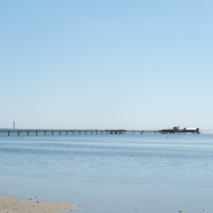
This wooden pier runs 572 meters into the Baltic Sea and ends at a restaurant. From the walkway you see open water, sailboats crossing the strait and the Danish coast on the horizon. In summer families come to swim, at sunset walkers arrive. The pier was built in the 19th century to dock ferries, today it serves as a viewing point and meeting spot for locals and travelers.
This island sits in the Baltic Sea and preserves a 16th-century observatory built by astronomer Tycho Brahe. The shoreline runs for a modest distance, and visitors can walk or cycle along paths that pass through open fields and small woods. An old lighthouse stands on the coast. The landscape remains flat, and from different points you can see the water all around. The island receives guests by ferry from the nearby harbor of Landskrona.
This castle has stood on a small island in Lake Mälaren since the 14th century. The red brick walls and four round towers have shaped the view since the Renaissance. Inside the rooms hang portraits of Swedish personalities from different centuries. The collection includes furniture and furnishings from the 16th century. A tour leads through halls with wooden ceilings, tiled stoves and paintings. The courtyard opens toward the water. From the towers you can see across the lake and the surrounding forests.
This stone fortification was built in 1658 on an island to control maritime trade. The building houses military exhibitions and historical rooms that tell the story of its strategic role. From the walls, views open across the sea and the surrounding archipelago islands. The fortress sits on a rock above the harbor town and served as a key defensive point along the Swedish west coast for centuries.
Gammelstad Church Town gathers around a medieval stone church. This settlement in northern Sweden is one of the few remaining church towns in the country. The community preserves 424 red wooden houses from the 15th century, which once served as lodgings for churchgoers. The narrow lanes and small buildings stand close together. Each house belonged to a family who traveled from distant farms to attend mass. The stone church dates from the Middle Ages and still holds services today. On weekends and feast days, visitors arrive to walk through the historic settlement and experience its quiet atmosphere.
This industrial site from the 18th century shows tools and methods of iron processing. The original buildings and machines remain in place. The facility belongs to Sweden's historical ironworks and offers a view into working life from past centuries. Visitors can walk through workshops and see how metal was once melted and shaped.
This coastal national park covers 390 hectares near the sea. A granite outcrop rises 97 meters (318 feet) above beaches and deciduous forests. The area offers trails through the woods and views across the water. The rock forms a landmark along this section of the Swedish coast. Visitors find sandy beaches and forested slopes in a natural landscape.
This migrating dune rises to a height of 130 feet (40 meters) and moves about 50 feet (15 meters) northeast each year. Råbjerg Mile covers one square kilometer and ranks among the largest moving dunes in northern Europe. The sand reshapes constantly through wind from the sea. Visitors can climb to the crest and cross the area that sits between the coast and inland terrain.
Ramsviklandet is a nature reserve with granite formations crossed by deep cracks. The rocks carry traces of glaciers from the ice age that moved through this landscape about 10,000 years ago, leaving characteristic lines and grooves carved into the stone.
This archipelago lies in the northern Gulf of Bothnia and forms part of a UNESCO World Heritage site. The island landscape emerged after the retreat of the ice age glaciers, when the land began to lift from the weight of the ice. The seabed continues to rise today, causing new islands to appear above the water and existing land masses to grow. Over 5,000 islands create a shifting mosaic of water, rock, and vegetation. Pine trees grow on the younger land, while older areas carry denser forests. During summer, locals use the islands for hiking and boating, and in winter the sea between the land masses freezes over. The light changes strongly with the seasons, from long summer days to short winter afternoons.
This red wooden house from the 18th century stands in Karlstad and once served as a manor estate. The museum now displays a collection of items that belonged to a Swedish poet. The rooms preserve the feeling of a grand country house from the time when Sweden was shaping its literary traditions. Visitors walk through chambers with original furnishings and discover manuscripts, personal belongings and furniture that tell the story of the poet's life and work. Alster's Herrgård sits away from the main routes and offers a window into the country's culture beyond the major cities.
These islands off the west coast form a group of 365 granite formations spread across the sea. The area sits in a part of Sweden where rock and open water shape the view. Seals swim between the islands, and migratory birds pass through in spring and fall. Most islands remain uninhabited, surrounded by water that changes with the weather. Fishermen have known the routes for generations. Visitors can take boats out and experience the quiet that settles here when only wind and waves break the silence.
This national park shows granite formations from the ice age between pine and spruce trees. A network of hiking trails crosses the forest. The forest grows on rocky ground shaped by glaciers. Visitors follow marked paths between the trees and over the rocks. The vegetation covers the ground with mosses and ferns, especially in the moist areas under the tree canopies. Tiveden is home to wildlife that lives among the trees. The trails connect different parts of the park and allow for several hours or full-day trips through this woodland area.
This museum displays rock carvings from the Bronze Age on red granite surfaces. The images include boats, people and cattle, documenting daily life from about 3000 years ago. The stones sit outdoors along marked paths. Information panels explain the scenes and their possible meanings. Vitlycke Museum serves as a starting point for visitors wanting to learn about these prehistoric sites in western Sweden.
This 600-meter (2,000-foot) harbor promenade connects red fishing houses and boat moorings along the coast. Fishermen sell their catch directly from the boats while visitors walk between the traditional wooden buildings. The setting reflects the maritime heritage of the region, where daily life on the water has continued for generations.
This museum preserves locomotives and railroad cars from the industrialization era on Gotland. The exhibition displays rail vehicles alongside tools for track maintenance. Visitors see technical equipment from past decades of Swedish railway history. The Railway Museum documents transportation and the development of rail infrastructure on the island.
This Iron Age monument consists of 59 stones arranged in the shape of a ship. The formation follows Nordic burial traditions and ranks among the larger preserved stone ships in Sweden. The stones stand on a rise above the Baltic Sea, where wind and weather have shaped their gray surfaces for centuries. Visitors can walk between the stones and view the construction from different angles. On clear days, the sea and surrounding fields stretch out from this point.
The chalk cliffs in Höllviken are a geological formation that contains fossils from the Cretaceous period. These cliffs stand in southern Sweden and reveal layers documenting changes in marine fauna over millions of years. The white rock faces are among the few visible chalk formations in the country, offering insight into past marine environments when this region lay underwater and was inhabited by sea creatures.
This open-air museum in Örebro brings together historical farmhouses from the region and demonstrates rural life from past centuries. Craftspeople demonstrate old techniques including blacksmithing, weaving and woodworking. The buildings come from different periods and have been rebuilt on this site to preserve Swedish building traditions. Visitors can walk through the farmyards, enter the living rooms and examine the tools of the time.
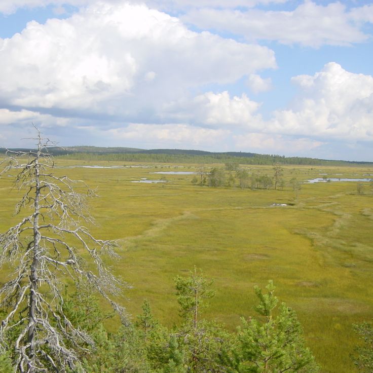
This national park preserves old traces of iron production amid meadows and forests rich in wildflowers. Visitors follow marked trails through changing landscapes where historic stone walls and clearings recall earlier use. The vegetation shifts between open areas and dense tree cover. In spring, many wildflowers bloom across the meadows, while old building remains tell of iron production from past centuries.
This national park on the eastern coast protects coastal forest on granite bedrock above the Gulf of Bothnia. Skuleskogen covers ridges where pine and spruce grow between moss-covered boulders. Trails lead through woodland to sandy coves and viewpoints over the water. Wildflowers bloom among the trees in spring, while autumn months turn the vegetation red and gold. The park shelters old-growth forest and natural shoreline formations.
This museum in central Kalmar focuses on Nordic and international art across four gallery rooms lit by skylights. The collection covers works from the 16th century to the present, including paintings, sculptures and installations. Changing exhibitions appear at regular intervals alongside the permanent collection. The building dates from the late 20th century and combines functional architecture with natural light filtering through roof windows into the exhibition spaces. The ground floor houses a museum shop and a café.
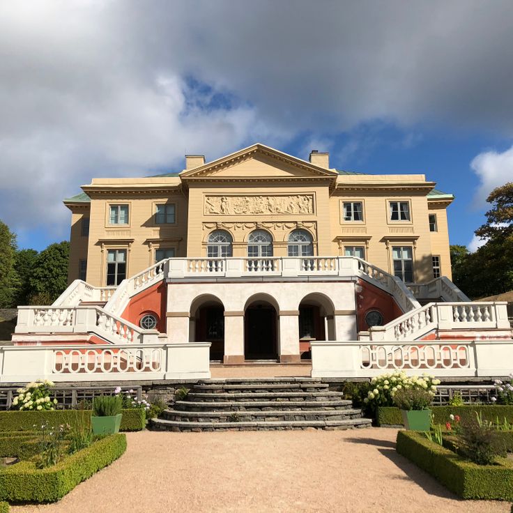
This city palace from 1898 preserves the living quarters of the noble Hallwyl family with their art collection and family library. The rooms show how a Stockholm aristocratic family lived at the turn of the 20th century. Visitors can walk through salons, dining rooms and private chambers furnished with furniture, paintings and objects from different periods.
This ninth century burial mound near Västerås ranks among the largest in Sweden. The site rises twelve meters above the surrounding field and holds five stone formations arranged around its base, along with two runestones carved with inscriptions from the Viking age. People in medieval times used this place to honor ancestors and display power. Visitors walk between the stones and grasp the scale of this burial ground, which stands on open land. The site connects to the prehistoric rock carvings and Viking traces found across many parts of the country.
This Baltic Sea island spreads across pine forests and sand dunes. The sand rises in places to about 100 feet (30 meters). A lighthouse from 1859 stands on the grounds and marks the coast for passing ships. The island sits isolated in the open sea, far from larger settlements. Visitors reach Gotska Sandön only by boat. Walking trails lead through the forests and along the dunes. Light filters through the pines onto sandy paths. In summer, beach grass blooms here and there among the dunes.
This island fortress was built in 1308 on a rock above the Nordre Älv River. Bohus Fortress withstood fourteen sieges without falling. The granite defense walls rise above the water, showing medieval military architecture. Visitors walk through the ruins of towers, casemates and living quarters. From the upper levels, views open onto the river and the surrounding landscape. The fortress once served as a strategic border post between Nordic kingdoms and played a central role in regional conflicts.
Fulufjället sits near the Norwegian border and protects highlands, forests and open moors. The Njupeskär waterfall drops 93 meters (305 feet) here, making it one of the tallest waterfalls in the country. This park is home to Tjikko, a spruce whose root system dates back roughly 9550 years, ranking among the oldest living trees on Earth. Trails lead through areas where reindeer roam, birch trees grow sparse and plateaus open wide under long summer daylight.
Nimis Artwork stands along the shoreline of Kullaberg and consists of driftwood collected from the beach. The structure reaches 16 meters in height and extends 75 meters along the coast. This wooden work was built without official permission and sits hidden among rocks and vegetation. Visitors reach the site by a steep path that descends from the parking area to the shore. The construction feels organic and blends into the natural surroundings of stone and sea.
This waterfront promenade runs along the harbor and shows buildings from the late 19th century. Strandvägen connects several city neighborhoods and passes facades in the Art Nouveau style. Boats rest at the quay where locals walk and visit cafés. The street follows the waterline and offers views across to the archipelago islands.
The King's Trail crosses four national parks in Swedish Lapland over a distance of more than 400 kilometers (250 miles). This long-distance footpath passes through birch forests, alpine valleys and high plateaus with glaciers. Hikers encounter reindeer herds and stay overnight in simple huts along the route. The trail connects mountain lakes and rivers in a landscape shaped by the changing seasons.
This national park near Lieksa protects peat bogs, coniferous forests and lakes across more than 100 square kilometers (40 square miles). Visitors follow marked trails through areas where sphagnum moss grows and birds nest. The landscape shows how water and soil interact in boreal zones. In summer, daylight lasts until late; in winter, snow covers the quiet expanses.
This island rises from the Baltic Sea near Oskarshamn, formed by smooth granite that slopes sharply toward the water. Blå Jungfrun was shaped by glacial movement and shows caves and boulder fields created by wind and weather over centuries. In Nordic myths, the place was considered a gathering spot for witches. Today the island is part of a national park and remains uninhabited.
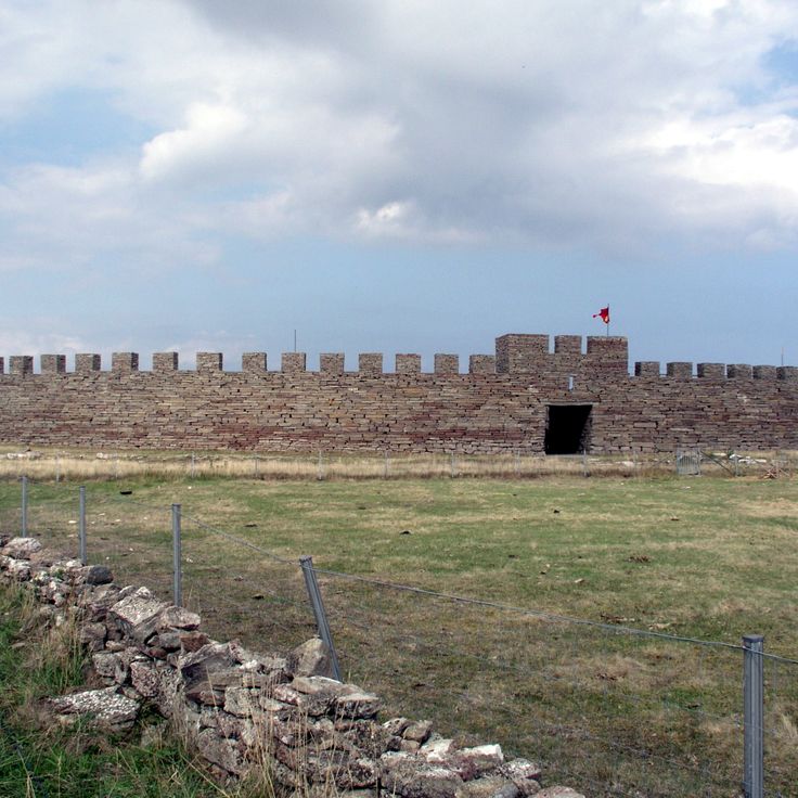
This 5th century fortification is among the best preserved Iron Age defensive sites in Scandinavia. Eketorp Fortress shows a circular layout with reconstructed houses, defense walls and workshops from the period between 400 and 1300 AD. Visitors can walk through the remains of residential buildings and see how people lived in this region during the Migration Period and the Middle Ages. The site sits on the island of Öland and was used and expanded in several phases.
This manor from the 18th century shows classical Swedish architecture with manicured gardens arranged in geometric patterns. The rooms preserve furniture and decoration from the construction period. An orangery stands among the beds. Visitors see how wealthy families lived at the time. The estate sits outside Gothenburg and connects interior spaces with outdoor areas following French design principles.
This wooden pier runs 572 meters into the Baltic Sea and ends at a restaurant. From the walkway you see open water, sailboats crossing the strait and the Danish coast on the horizon. In summer families come to swim, at sunset walkers arrive. The pier was built in the 19th century to dock ferries, today it serves as a viewing point and meeting spot for locals and travelers.
This island sits in the Baltic Sea and preserves a 16th-century observatory built by astronomer Tycho Brahe. The shoreline runs for a modest distance, and visitors can walk or cycle along paths that pass through open fields and small woods. An old lighthouse stands on the coast. The landscape remains flat, and from different points you can see the water all around. The island receives guests by ferry from the nearby harbor of Landskrona.
This castle has stood on a small island in Lake Mälaren since the 14th century. The red brick walls and four round towers have shaped the view since the Renaissance. Inside the rooms hang portraits of Swedish personalities from different centuries. The collection includes furniture and furnishings from the 16th century. A tour leads through halls with wooden ceilings, tiled stoves and paintings. The courtyard opens toward the water. From the towers you can see across the lake and the surrounding forests.