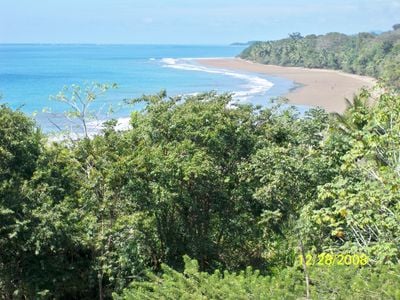
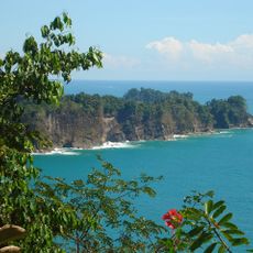
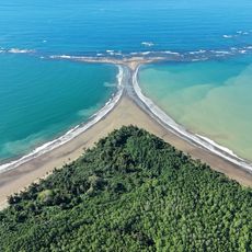
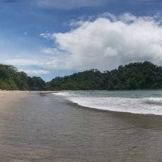
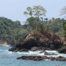
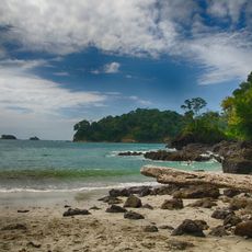
Colonia Beach, Sandy beach in Bahía Ballena, Costa Rica
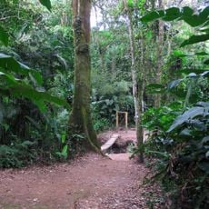
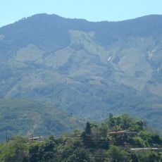
Colonia Beach extends along the Pacific coast with smooth breaking waves, a sandy bottom, and mountains rising in the background.
The integration of Colonia Beach into Marino Ballena National Park in 1989 marked its transformation into a protected marine conservation area.
Local surfers maintain an active presence at Colonia Beach, sharing their knowledge of wave patterns with newcomers to the sport.
Visitors can access camping facilities with full services directly on the beach, including showers for after-swim convenience.
The beach maintains low visitor numbers throughout the year, creating natural spaces for both beginner and advanced surfers to practice.
Location: Bahía Ballena
GPS coordinates: 9.15216,-83.74212
Latest update: March 4, 2025 01:10
Costa Rica spans 19,700 square miles (51,100 square kilometers) between the Pacific Ocean and Caribbean Sea, offering photographers a concentration of varied landscapes within a compact area. The country maintains over 30 national parks and protected areas, including Arenal Volcano, whose near-perfect cone rises 5,479 feet (1,670 meters) above surrounding rainforest, and Monteverde Cloud Forest, where mist drifts through canopy vegetation supporting rare species such as the resplendent quetzal. Rio Celeste flows through Tenorio Volcano National Park, displaying its characteristic turquoise color from volcanic minerals, while Tabacon Hot Springs delivers naturally heated water from underground sources. Coastal regions present diverse subjects, from the beaches of Manuel Antonio National Park, where white-faced capuchin monkeys move through trees, to Cahuita National Park on the Caribbean coast with its coral reefs. The Nicoya Peninsula and Papagayo Peninsula provide access to Tamarindo Beach and Santa Teresa Beach, while the southern zone includes Marino Ballena National Park, named for its whale-shaped sandbar visible at low tide. Tortuga Island, off the coast of Puntarenas, serves as a day-trip destination. Inland, San Jose Central Market documents daily commerce, the National Theater displays neoclassical architecture from 1897, and Guayabo National Monument preserves pre-Columbian ruins. Cerro Chirripó rises to 12,533 feet (3,820 meters) as the country's highest point, offering views of both oceans in clear conditions.
Stone spheres of Costa Rica
39.6 km
Manuel Antonio National Park
49.9 km
Corcovado National Park
69.3 km
Cerro Chirripó
46.3 km
Guayabo National Monument
91.5 km
La Amistad International Park
92.9 km
Cerro de la Muerte
44.8 km
Irazú Volcano National Park
92.6 km
Nuestra Señora de los Ángeles
81.4 km
Orosi Church
72.9 km
Chirripó National Park
46.5 km
Talamanca Reserve
92.7 km
Parque del Este
92.8 km
Los Quetzales National Park
51.6 km
Ballena ("Whale") Marine National Park
6.8 km
Tapantí National Park
69.1 km
Piedras Blancas National Park
73 km
Lankester Botanical Garden
78.2 km
Cerro Caraigres
77 km
Cerro Ventisqueros
44.1 km
Our Lady of Carmel Cathedral, Cartago
81.8 km
Iglesia de San Diego (La Unión)
88 km
Nauyaca Waterfalls
13.5 km
Isla del Caño Lighthouse
52.2 km
Playa Espadilla Sur
51.9 km
Talamanca Range-La Amistad Reserves
92.7 km
Playa Gemelas
50.7 km
Beach at Manuel Antonio Park
51.3 kmReviews
Visited this place? Tap the stars to rate it and share your experience / photos with the community! Try now! You can cancel it anytime.
Discover hidden gems everywhere you go!
From secret cafés to breathtaking viewpoints, skip the crowded tourist spots and find places that match your style. Our app makes it easy with voice search, smart filtering, route optimization, and insider tips from travelers worldwide. Download now for the complete mobile experience.
A unique approach to discovering new places❞
— Le Figaro
All the places worth exploring❞
— France Info
A tailor-made excursion in just a few clicks❞
— 20 Minutes