Cerro Ventisqueros, Mountain summit in Pérez Zeledón Canton, Costa Rica
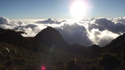
Cerro Ventisqueros is a high mountain summit in the Cordillera de Talamanca rising to 3,812 meters above sea level. The peak stands among subalpine terrain and sits just 8 meters lower than the country's highest point.
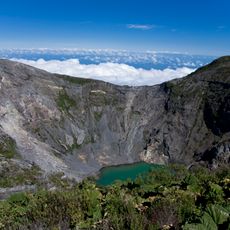
The mountain is part of the Cordillera de Talamanca, a mountain range formed over millions of years through tectonic movement between Caribbean and Pacific plates. This geological history shaped the landscape and makes the region one of the oldest mountain ranges in the Americas.
The name comes from the powerful winds that sweep across the summit and create snowdrift patterns, a phenomenon that shaped local understanding of the mountain. These winds remain a defining characteristic that connects the place to the stories people tell about it.
The hike to the summit is demanding and requires good physical fitness due to steep and exposed terrain. The best time to climb is during the drier months when snow and ice are less likely to block the route.
On clear days, visitors can see both the Pacific and Caribbean oceans from the peak, a rare experience possible from only a handful of summits in the region. The Valley of Lakes and neighboring Cerro Chirripó are also visible from this exceptional vantage point.
The community of curious travelers
AroundUs brings together thousands of curated places, local tips, and hidden gems, enriched daily by 60,000 contributors worldwide.