Chest opened
+${chestReward.xp} XP
Explorer
NOUVEAU ×${chestReward.collectible.quantity}
tapez pour fermer
Chest locked

Open chests in the app

Around Us is built for your phone — chests unlock when you walk, explore and capture nearby places.

Enable Location

We need your location to show you interesting places around you

Discover nearby places

Find interesting locations and hidden gems around you

Precise directions

Get accurate directions and distances to places

Your location is never shared with other users. It's only used when you tap the location button.

King Island

Log in to your account

Start exploring — it's free

Trusted by 72,879 travelers worldwide

Continue with Google
Continue with Apple
or

We will send you a code to connect

By continuing, you accept our Terms and Conditions and our Privacy Policy

Check your inbox

We've sent a pincode in your inbox. Please enter the code below.

King Island
Discussion Reviews 1 Photos
13.4k Popularity

King Island, Island in Bering Sea, Alaska, US.

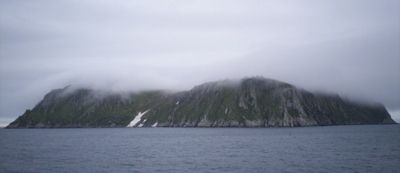
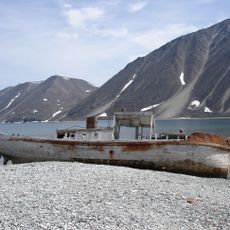
King Island is an island in the Bering Sea off western Alaska, featuring steep cliffs that rise directly from the water. The terrain is rocky and harsh, shaped by rough conditions and difficult to reach from the mainland.

British Captain James Cook documented the island in 1778 and named it after his crew member James King. For centuries before that, it served as a hunting base for the native population, though people eventually left the area.

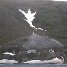
The Iñupiat people lived here for generations, developing specialized hunting techniques adapted to the harsh Bering Sea environment. These practices shaped how residents understood and used the land around them.

The island is uninhabited today and difficult to reach, requiring arrangements through Nome, Alaska. Visitors should expect rough weather conditions and limited accessibility to most areas.

Between 2005 and 2006, researchers brought back former residents to document their deep knowledge of the island and its traditions. This project helped preserve understanding of how the community once lived and used this place.

The community of curious travelers

AroundUs brings together thousands of curated places, local tips, and hidden gems, enriched daily by 60,000 contributors worldwide.

Start exploring
Location
GPS coordinates
64.96667,-168.08333
Latest update
December 7, 2025 20:40
Around this place
Naukan
Russian Federation

Naukan

139 km
Whale Bone Alley
Russian Federation

Whale Bone Alley

213.4 km
Beringia National Park
Russian Federation

Beringia National Park

257.2 km
Monument to Semyon Dezhnev
Russian Federation

Monument to Semyon Dezhnev

139.2 km
Trail Creek Caves
United States of America

Trail Creek Caves

235 km
Selawik National Wildlife Refuge
United States of America

Selawik National Wildlife Refuge

444.7 km
Pilgrim Hot Springs
United States of America

Pilgrim Hot Springs

149.2 km
Cape Nome Mining District Discovery Sites
United States of America

Cape Nome Mining District Discovery Sites

136.3 km
Unalakleet River
United States of America

Unalakleet River

405.2 km
Council City and Solomon River Railroad
United States of America

Council City and Solomon River Railroad

179.5 km
Old St. Joseph's Catholic Church
United States of America

Old St. Joseph's Catholic Church

137.3 km
Nome River
United States of America

Nome River

137.6 km
Snake River
United States of America

Snake River

129.4 km
Chamisso Wilderness
United States of America

Chamisso Wilderness

319.9 km
Wales Site
United States of America

Wales Site

71.4 km
Kougarok River
United States of America

Kougarok River

167.5 km
Squirrel River
United States of America

Squirrel River

405.7 km
Kuzitrin River
United States of America

Kuzitrin River

176.9 km
Swanberg Dredge
United States of America

Swanberg Dredge

139.5 km
Solomon Roadhouse
United States of America

Solomon Roadhouse

178.8 km
Niukluk River
United States of America

Niukluk River

196.1 km
Iyatayet Site
United States of America

Iyatayet Site

318.6 km
Kugruk River
United States of America

Kugruk River

273.1 km
Shishmaref Inlet
United States of America

Shishmaref Inlet

176.6 km
Noxapaga River
United States of America

Noxapaga River

199.4 km
Bureau of Indian Affairs Unalakleet School
United States of America

Bureau of Indian Affairs Unalakleet School

371.2 km
Slavyanka Cove
Russian Federation

Slavyanka Cove

259.3 km
Историко-культурный комплекс Пловер
Russian Federation

Историко-культурный комплекс Пловер

259.9 km
Show the full map
Reviews
Share your experience

No review yet

Discussions
Start a discussion...

No discussion yet

« King Island - Island in Bering Sea, Alaska, US » is provided by Around Us (aroundus.com). Images and texts are derived from Wikimedia project under a Creative Commons license. You are allowed to copy, distribute, and modify copies of this page, under the conditions set by the license, as long as this note is clearly visible.

Discover hidden gems everywhere you go!

From secret cafés to breathtaking viewpoints, skip the crowded tourist spots and find places that match your style. Our app makes it easy with voice search, smart filtering, route optimization, and insider tips from travelers worldwide. Download now for the complete mobile experience.

Around Us App Screenshot

A unique approach to discovering new places

Le Figaro

All the places worth exploring

France Info

A tailor-made excursion in just a few clicks

20 Minutes

Around Us
Travel Guide & Maps
Download

Send to your phone

QR Code
1

Open the camera app on your mobile.

2

Point at the QR code with your camera. A notification will appear.

3

Tap the notification to open the link.