Chest opened
+${chestReward.xp} XP
Explorer
NOUVEAU ×${chestReward.collectible.quantity}
tapez pour fermer
Chest locked

Open chests in the app

Around Us is built for your phone — chests unlock when you walk, explore and capture nearby places.

Enable Location

We need your location to show you interesting places around you

Discover nearby places

Find interesting locations and hidden gems around you

Precise directions

Get accurate directions and distances to places

Your location is never shared with other users. It's only used when you tap the location button.

Kiwalik River

Log in to your account

Start exploring — it's free

Trusted by 72,885 travelers worldwide

Continue with Google
Continue with Apple
or

We will send you a code to connect

By continuing, you accept our Terms and Conditions and our Privacy Policy

Check your inbox

We've sent a pincode in your inbox. Please enter the code below.

Kiwalik River
Discussion Reviews 1 Photos
1.5k Popularity

Kiwalik River, River in Northwest Arctic Borough, Alaska

The Kiwalik River is a waterway on the Seward Peninsula that flows northward to Spafarief Bay where it meets the Chukchi Sea. It narrows upstream of Candle but widens into navigable lagoons as it approaches the coast.

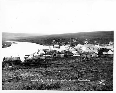
During the early 1900s gold rush, mining operations developed along the river, particularly at Candle Creek. This period brought rapid growth to the region but declined as mineral supplies ran out.

The Inupiat people have called this waterway Kuugaaluk for generations and built settlements along its banks. These communities reflect a long connection between the local population and the river.

The best time to visit is the short summer season when ice melts and the river becomes navigable. Boaters should watch for narrow sections upstream of Candle where passage becomes more challenging.

The river basin contains diverse minerals including galena, pyrite, and scheelite, with notable tungsten and zinc deposits. These mineral resources attracted mining interest during the early 1900s.

The community of curious travelers

AroundUs brings together thousands of curated places, local tips, and hidden gems, enriched daily by 60,000 contributors worldwide.

Start exploring
Location
GPS coordinates
65.98174,-161.85981
Latest update
December 14, 2025 14:44
Around this place
Kobuk Valley National Park
United States of America

Kobuk Valley National Park

208 km
Trail Creek Caves
United States of America

Trail Creek Caves

73.9 km
Noatak Wilderness
United States of America

Noatak Wilderness

252.6 km
Koyukuk National Wildlife Refuge
United States of America

Koyukuk National Wildlife Refuge

248.6 km
Selawik National Wildlife Refuge
United States of America

Selawik National Wildlife Refuge

137.9 km
Cape Nome Mining District Discovery Sites
United States of America

Cape Nome Mining District Discovery Sites

227.2 km
Unalakleet River
United States of America

Unalakleet River

239.5 km
Old St. Joseph's Catholic Church
United States of America

Old St. Joseph's Catholic Church

233.5 km
Selawik River
United States of America

Selawik River

166.5 km
Nome River
United States of America

Nome River

217.7 km
Snake River
United States of America

Snake River

224.7 km
Chamisso Wilderness
United States of America

Chamisso Wilderness

27.1 km
Onion Portage Archeological District
United States of America

Onion Portage Archeological District

200.8 km
Wales Site
United States of America

Wales Site

287 km
Kougarok River
United States of America

Kougarok River

142 km
Squirrel River
United States of America

Squirrel River

148.1 km
Kuzitrin River
United States of America

Kuzitrin River

138.1 km
Swanberg Dredge
United States of America

Swanberg Dredge

232.8 km
Solomon Roadhouse
United States of America

Solomon Roadhouse

198.7 km
Niukluk River
United States of America

Niukluk River

150.6 km
Iyatayet Site
United States of America

Iyatayet Site

175.8 km
Kugruk River
United States of America

Kugruk River

35.8 km
Shishmaref Inlet
United States of America

Shishmaref Inlet

184.3 km
Salmon River
United States of America

Salmon River

193.5 km
Noxapaga River
United States of America

Noxapaga River

109.7 km
Bureau of Indian Affairs Unalakleet School
United States of America

Bureau of Indian Affairs Unalakleet School

240.3 km
Kugururok River
United States of America

Kugururok River

261.5 km
Bering Land Bridge Visitor Center
United States of America

Bering Land Bridge Visitor Center

233.7 km
Show the full map
Reviews
Share your experience

No review yet

Discussions
Start a discussion...

No discussion yet

« Kiwalik River - River in Northwest Arctic Borough, Alaska » is provided by Around Us (aroundus.com). Images and texts are derived from Wikimedia project under a Creative Commons license. You are allowed to copy, distribute, and modify copies of this page, under the conditions set by the license, as long as this note is clearly visible.

Discover hidden gems everywhere you go!

From secret cafés to breathtaking viewpoints, skip the crowded tourist spots and find places that match your style. Our app makes it easy with voice search, smart filtering, route optimization, and insider tips from travelers worldwide. Download now for the complete mobile experience.

Around Us App Screenshot

A unique approach to discovering new places

Le Figaro

All the places worth exploring

France Info

A tailor-made excursion in just a few clicks

20 Minutes

Around Us
Travel Guide & Maps
Download

Send to your phone

QR Code
1

Open the camera app on your mobile.

2

Point at the QR code with your camera. A notification will appear.

3

Tap the notification to open the link.