Utqiagvik

Log in to your account

AroundUs is a community-driven map of interesting places, built by curious explorers like you. It grows with every review, story, and photo you share.
Connect to save your favorite spots, contribute locations, and create personalized routes.
By continuing, you accept our Terms and Conditions and our Privacy Policy
Add to collection
Map
Suggest a change
Share

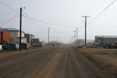
Utqiagvik, Northernmost city in Alaska, United States
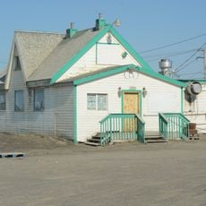
Utqiagvik stands on the Chukchi Sea coast at an elevation of 3 meters, surrounded by tundra landscape and permafrost terrain.

The settlement area contains archaeological evidence of Iñupiat communities dating back to 500 AD, with ancient sod houses visible along the Arctic shore.

The Iñupiat people maintain their traditions through the Kivgiq Messenger Feast and Nalukataq celebrations, which occur after successful whale hunting expeditions.

Transportation to Utqiagvik relies on the Wiley Post-Will Rogers Memorial Airport, as no roads connect the city to other Alaskan communities.

The city experiences 65 days of complete darkness during winter and 80 days of continuous sunlight in summer due to its location above the Arctic Circle.

Location: North Slope Borough

Inception: June 8, 1959

Elevation above the sea: 3 m

Website: https://utqiagvik.us

GPS coordinates: 71.29056,-156.78861

Latest update: May 27, 2025 20:08

Remote places: deserts, islands, research stations

This collection covers places in remote deserts, isolated islands, and inaccessible mountain regions where human settlement is limited to a minimum. They range from research stations in Antarctica such as McMurdo Station and the Amundsen-Scott South Pole Station to the French Kerguelen Islands in the southern Indian Ocean. The collection includes settlements without road access like the village of Supai deep in the Grand Canyon of Arizona, reachable only on foot, by helicopter, or by mule, as well as Ittoqqortoormiit on the eastern coast of Greenland. Other locations are Easter Island in the Pacific, located over 2300 miles (3700 kilometers) from mainland Chile, and Tristan da Cunha, an inhabited island group in the middle of the South Atlantic. Extreme locations include Alert in Nunavut, Canada, the northernmost permanently inhabited settlement in the world, the Siberian village of Oymyakon with its exceptionally low winter temperatures, and the Yemeni island of Socotra with its peculiar flora. The collection also includes the Siwa Oasis in the Egyptian desert, Motuo County in Tibet, and the Scottish island of Foula.

Around this place
Show the full map
Arctic National Wildlife Refuge
United States of America

Arctic National Wildlife Refuge

577.5 km
Kobuk Valley National Park
United States of America

Kobuk Valley National Park

427.6 km
Mount Isto
United States of America

Mount Isto

539.6 km
Rogers-Post Site
United States of America

Rogers-Post Site

17.7 km
Point Barrow Long Range Radar Site
United States of America

Point Barrow Long Range Radar Site

6.8 km
Gates of the Arctic Wilderness
United States of America

Gates of the Arctic Wilderness

383 km
Ipiutak Site
United States of America

Ipiutak Site

505 km
Mount Igikpak
United States of America

Mount Igikpak

437.5 km
Arrigetch Peaks
United States of America

Arrigetch Peaks

442.8 km
Point Barrow Refuge Station
United States of America

Point Barrow Refuge Station

980 m
Leffingwell Camp Site
United States of America

Leffingwell Camp Site

412.4 km
Noatak Wilderness
United States of America

Noatak Wilderness

374.5 km
Kanuti National Wildlife Refuge
United States of America

Kanuti National Wildlife Refuge

577.4 km
John River
United States of America

John River

465.8 km
Selawik National Wildlife Refuge
United States of America

Selawik National Wildlife Refuge

532.5 km
Birnirk Site
United States of America

Birnirk Site

1.6 km
North Fork Koyukuk River
United States of America

North Fork Koyukuk River

485.3 km
Selawik River
United States of America

Selawik River

536.8 km
Chamisso Wilderness
United States of America

Chamisso Wilderness

598.9 km
Gallagher Flint Station Archeological Site
United States of America

Gallagher Flint Station Archeological Site

370.7 km
Onion Portage Archeological District
United States of America

Onion Portage Archeological District

470.6 km
Itkillik River
United States of America

Itkillik River

326.9 km
Squirrel River
United States of America

Squirrel River

477.7 km
Walker Lake
United States of America

Walker Lake

473.2 km
Iñupiat Heritage Center
United States of America

Iñupiat Heritage Center

1.6 km
Peters Glacier (Brooks Range)
United States of America

Peters Glacier (Brooks Range)

496.4 km
Utqiaġvik Church Manse
United States of America

Utqiaġvik Church Manse

396 m
Salmon River
United States of America

Salmon River

436.5 km
Show the full map

Reviews

Visited this place? Tap the stars to rate it and share your experience / photos with the community! Try now! You can cancel it anytime.

« Utqiagvik: Northernmost city in Alaska, United States » is provided by Around Us (aroundus.com). Images and texts are derived from Wikimedia project under a Creative Commons license. You are allowed to copy, distribute, and modify copies of this page, under the conditions set by the license, as long as this note is clearly visible.

Discover hidden gems everywhere you go!

From secret cafés to breathtaking viewpoints, skip the crowded tourist spots and find places that match your style. Our app makes it easy with voice search, smart filtering, route optimization, and insider tips from travelers worldwide. Download now for the complete mobile experience.

Around Us App Screenshot

A unique approach to discovering new places

Le Figaro

All the places worth exploring

France Info

A tailor-made excursion in just a few clicks

20 Minutes