Chest opened
+${chestReward.xp} XP
Explorer
NOUVEAU ×${chestReward.collectible.quantity}
tapez pour fermer
Chest locked

Open chests in the app

Around Us is built for your phone — chests unlock when you walk, explore and capture nearby places.

Enable Location

We need your location to show you interesting places around you

Discover nearby places

Find interesting locations and hidden gems around you

Precise directions

Get accurate directions and distances to places

Your location is never shared with other users. It's only used when you tap the location button.

Greenfield

Log in to your account

Start exploring — it's free

Trusted by 72,888 travelers worldwide

Continue with Google
Continue with Apple
or

We will send you a code to connect

By continuing, you accept our Terms and Conditions and our Privacy Policy

Check your inbox

We've sent a pincode in your inbox. Please enter the code below.

Discussion Reviews 1 Photos
18k Popularity

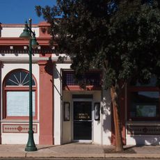
Greenfield, city in Monterey County, California, United States

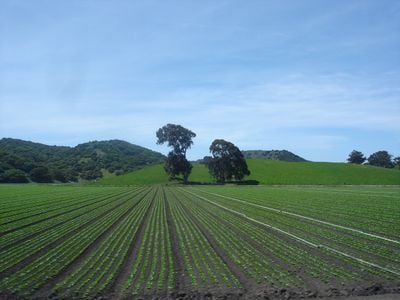
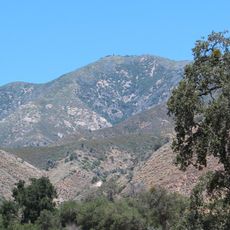
Greenfield is a city in Monterey County located in the fertile Salinas Valley and surrounded by mountain ranges on both sides. The landscape is defined by vegetable fields and vineyards, with agriculture and food production serving as the central elements of community life.

Greenfield was officially founded as a city in 1947, previously known as Clarke Colony, a settlement established in the early 1900s. Founders built a water system from the Arroyo Seco stream that allowed year-round irrigation of the fields.

Greenfield earned the nickname "Broccoli Capital of the World" for its role in vegetable farming, and this identity shapes daily life in the community. Spanish is spoken widely in homes and shops, and residents maintain traditions and food practices rooted in Latin American heritage.

Greenfield sits directly on U.S. Route 101, providing easy access to neighboring towns like Salinas and Carmel. The city's flat layout makes it straightforward to navigate on foot or by car between farms, wineries, and shops.

The Harvest Festival in October brings the community together to celebrate farming work, with streets filled with music, local food, and booths. This event shows how deeply the seasons and harvest cycles shape the rhythm of life here.

The community of curious travelers

AroundUs brings together thousands of curated places, local tips, and hidden gems, enriched daily by 60,000 contributors worldwide.

Start exploring
Location
Inception
January 7, 1947
Shares border with
Soledad
GPS coordinates
36.32083,-121.24389
Latest update
February 17, 2026 00:00
Around this place
Big Sur
United States of America

Big Sur

41.7 km
Pinnacles National Park
United States of America

Pinnacles National Park

19.7 km
McWay Falls
United States of America

McWay Falls

42.4 km
Mission San Antonio de Padua
United States of America

Mission San Antonio de Padua

34 km
Julia Pfeiffer Burns State Park
United States of America

Julia Pfeiffer Burns State Park

41.9 km
Mission Nuestra Señora de la Soledad
United States of America

Mission Nuestra Señora de la Soledad

13.7 km
Tassajara Zen Mountain Center
United States of America

Tassajara Zen Mountain Center

31.6 km
Tassajara Hot Springs
United States of America

Tassajara Hot Springs

29.1 km
Limekiln State Park
United States of America

Limekiln State Park

42.5 km
Ventana Wilderness
United States of America

Ventana Wilderness

38.8 km
The Hacienda
United States of America

The Hacienda

34.5 km
Junipero Serra Peak
United States of America

Junipero Serra Peak

25.1 km
Big Creek Bridge
United States of America

Big Creek Bridge

42.5 km
Big Creek State Marine Reserve and Big Creek State Marine Conservation Area
United States of America

Big Creek State Marine Reserve and Big Creek State Marine Conservation Area

41.4 km
San Clemente Dam
United States of America

San Clemente Dam

43.6 km
Laguna Mountain Recreation Area
United States of America

Laguna Mountain Recreation Area

35.4 km
Hernandez Reservoir
United States of America

Hernandez Reservoir

38.3 km
King City High School Auditorium
United States of America

King City High School Auditorium

15.9 km
Pinnacles National Forest
United States of America

Pinnacles National Forest

20.3 km
Monterey Zoo
United States of America

Monterey Zoo

45.7 km
Odd Fellows Hall
United States of America

Odd Fellows Hall

27.4 km
Mission Soledad Museum
United States of America

Mission Soledad Museum

13.7 km
Bear Gulch Reservoir
United States of America

Bear Gulch Reservoir

17.5 km
Juniper Canyon Trail
United States of America

Juniper Canyon Trail

18.4 km
Fort Hunter Liggett
United States of America

Fort Hunter Liggett

41.1 km
Balconies Trail
United States of America

Balconies Trail

19.7 km
Bear Valley School
United States of America

Bear Valley School

25.3 km
Chalone Peak Lookout
United States of America

Chalone Peak Lookout

14.8 km
Show the full map
Reviews
Share your experience

No review yet

Discussions
Start a discussion...

No discussion yet

« Greenfield - city in Monterey County, California, United States » is provided by Around Us (aroundus.com). Images and texts are derived from Wikimedia project under a Creative Commons license. You are allowed to copy, distribute, and modify copies of this page, under the conditions set by the license, as long as this note is clearly visible.

Discover hidden gems everywhere you go!

From secret cafés to breathtaking viewpoints, skip the crowded tourist spots and find places that match your style. Our app makes it easy with voice search, smart filtering, route optimization, and insider tips from travelers worldwide. Download now for the complete mobile experience.

Around Us App Screenshot

A unique approach to discovering new places

Le Figaro

All the places worth exploring

France Info

A tailor-made excursion in just a few clicks

20 Minutes

Around Us
Travel Guide & Maps
Download

Send to your phone

QR Code
1

Open the camera app on your mobile.

2

Point at the QR code with your camera. A notification will appear.

3

Tap the notification to open the link.