Chest opened
+${chestReward.xp} XP
Explorer
NOUVEAU ×${chestReward.collectible.quantity}
tapez pour fermer
Chest locked

Open chests in the app

Around Us is built for your phone — chests unlock when you walk, explore and capture nearby places.

Enable Location

We need your location to show you interesting places around you

Discover nearby places

Find interesting locations and hidden gems around you

Precise directions

Get accurate directions and distances to places

Your location is never shared with other users. It's only used when you tap the location button.

California State Route 49

Log in to your account

Start exploring — it's free

Trusted by 72,996 travelers worldwide

Continue with Google
Continue with Apple
or

We will send you a code to connect

By continuing, you accept our Terms and Conditions and our Privacy Policy

Check your inbox

We've sent a pincode in your inbox. Please enter the code below.

California State Route 49
Discussion Reviews 1 Photos
21.5k Popularity

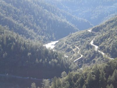
California State Route 49, state highway in California, United States

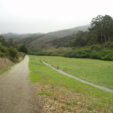
California State Route 49 is a regional highway that runs through the Sierra Nevada mountain range, connecting multiple counties in central California. The road passes through forested terrain, small historic towns, and varied elevations as it winds through the foothills.

The route traces the paths of 19th century Gold Rush transportation and was later developed to connect these historic communities. Many small towns along the road began as mining settlements during that era.

The road experiences varying conditions depending on season and can be snowy or icy during winter months. Drivers should prepare for winding sections and elevation changes while taking care in poor weather.

The route is sometimes called California's Golden Triangle, offering one of the best ways to see the well-preserved Victorian architecture and old-town character of these Gold Rush communities in succession. Many travelers use it as a scenic route to visit multiple historic sites in a single trip.

The community of curious travelers

AroundUs brings together thousands of curated places, local tips, and hidden gems, enriched daily by 60,000 contributors worldwide.

Start exploring
Location
Location
Location
Location
Location
Location
Location
Location
Location
Location
Location
Inception
1934
GPS coordinates
37.63279,-122.41971
Latest update
December 14, 2025 17:01
Around this place
San Andreas Lake
United States of America

San Andreas Lake

4.4 km
Pacifica State Beach
United States of America

Pacifica State Beach

7.9 km
Dakin Building
United States of America

Dakin Building

5.8 km
South San Francisco Hillside Sign
United States of America

South San Francisco Hillside Sign

3.2 km
San Bruno Mountain State Park
United States of America

San Bruno Mountain State Park

6.1 km
San Francisco Bay Discovery Site
United States of America

San Francisco Bay Discovery Site

4.6 km
Pacifica Pier
United States of America

Pacifica Pier

6.5 km
Kohl Mansion
United States of America

Kohl Mansion

6.4 km
Pedro Mountain Road
United States of America

Pedro Mountain Road

8.7 km
Brisbane Baylands development
United States of America

Brisbane Baylands development

8.4 km
Sánchez Adobe Park
United States of America

Sánchez Adobe Park

8.2 km
South San Francisco Public Library
United States of America

South San Francisco Public Library

2.6 km
Congregation B’nai Israel
United States of America

Congregation B’nai Israel

7.9 km
Peninsula Temple Sholom
United States of America

Peninsula Temple Sholom

6.3 km
Leo J. Ryan Federal Building
United States of America

Leo J. Ryan Federal Building

475 m
San Pedro Valley County Park
United States of America

San Pedro Valley County Park

7.8 km
Spur Trail
United States of America

Spur Trail

4.8 km
Salem Memorial Park and Garden
United States of America

Salem Memorial Park and Garden

6.1 km
Every Beating Second
United States of America

Every Beating Second

3.7 km
Cow Palace
United States of America

Cow Palace

8.2 km
SFO Museum
United States of America

SFO Museum

3.2 km
Sharp Park Beach
United States of America

Sharp Park Beach

6.7 km
Wyatt Earp gravesite
United States of America

Wyatt Earp gravesite

5.6 km
Visitacion Valley Branch Library
United States of America

Visitacion Valley Branch Library

8.9 km
Wind Harp
United States of America

Wind Harp

3.9 km
Howard–Ralston Eucalyptus Tree Rows
United States of America

Howard–Ralston Eucalyptus Tree Rows

7.6 km
San Pedro Beach
United States of America

San Pedro Beach

8.3 km
Rockaway Beach
United States of America

Rockaway Beach

7.3 km
Show the full map
Reviews
Share your experience

No review yet

Discussions
Start a discussion...

No discussion yet

« California State Route 49 - state highway in California, United States » is provided by Around Us (aroundus.com). Images and texts are derived from Wikimedia project under a Creative Commons license. You are allowed to copy, distribute, and modify copies of this page, under the conditions set by the license, as long as this note is clearly visible.

Discover hidden gems everywhere you go!

From secret cafés to breathtaking viewpoints, skip the crowded tourist spots and find places that match your style. Our app makes it easy with voice search, smart filtering, route optimization, and insider tips from travelers worldwide. Download now for the complete mobile experience.

Around Us App Screenshot

A unique approach to discovering new places

Le Figaro

All the places worth exploring

France Info

A tailor-made excursion in just a few clicks

20 Minutes

Around Us
Travel Guide & Maps
Download

Send to your phone

QR Code
1

Open the camera app on your mobile.

2

Point at the QR code with your camera. A notification will appear.

3

Tap the notification to open the link.