Enable Location

We need your location to show you interesting places around you

Discover nearby places

Find interesting locations and hidden gems around you

Precise directions

Get accurate directions and distances to places

Your location is never shared with other users. It's only used when you tap the location button.

Wilson River Bridge

Log in to your account

Start exploring — it's free

Trusted by 61,905 travelers worldwide

Continue with Google
Continue with Apple
or

We will send you a code to connect

By continuing, you accept our Terms and Conditions and our Privacy Policy

Check your inbox

We've sent a pincode in your inbox. Please enter the code below.

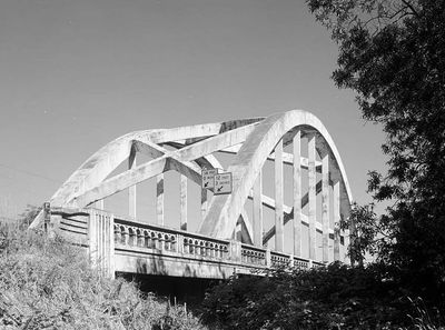
Wilson River Bridge, Road bridge in Tillamook, US

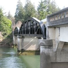
Wilson River Bridge is a road bridge that carries U.S. Route 101 across the Wilson River near Tillamook with a tied-arch structure made of reinforced concrete. The span connects communities throughout the coastal region and remains an important passage for travelers moving through Oregon.

The bridge was built in 1931 during a period of major infrastructure development in the Pacific Northwest. Its construction marked an important advancement in how road bridges were designed and engineered in that era.

The Wilson River Bridge stands as an engineering achievement from the early 20th century, representing the development of American transportation infrastructure.

You can view the bridge from U.S. Route 101, with several pullouts along the highway offering good sight lines to examine its structure. Plan time for photos if you want to capture details of the arch and concrete work.

The bridge was among the first of its type to use reinforcing bars instead of steel plates in the arch, an innovative technical choice for the time. This construction method influenced how similar structures were later built throughout the region.

The community of curious travelers

AroundUs brings together thousands of curated places, local tips, and hidden gems, enriched daily by 60,000 contributors worldwide.

Start exploring
Location
Inception
1931
GPS coordinates
45.47833,-123.84333
Latest update
December 14, 2025 16:40
Around this place
Tillamook Air Museum
United States of America

Tillamook Air Museum

7.1 km
Cape Kiwanda State Natural Area
United States of America

Cape Kiwanda State Natural Area

30.8 km
Oswald West State Park
United States of America

Oswald West State Park

33.7 km
Nehalem Bay State Park
United States of America

Nehalem Bay State Park

25.5 km
Neahkahnie Mountain
United States of America

Neahkahnie Mountain

31.1 km
Cape Lookout State Park
United States of America

Cape Lookout State Park

17.2 km
Cape Meares Lighthouse
United States of America

Cape Meares Lighthouse

10.6 km
Three Arch Rocks National Wildlife Refuge
United States of America

Three Arch Rocks National Wildlife Refuge

11.5 km
Short Beach
United States of America

Short Beach

9.7 km
Naval Air Station Tillamook
United States of America

Naval Air Station Tillamook

7.4 km
Munson Creek Falls State Natural Site
United States of America

Munson Creek Falls State Natural Site

13.8 km
Bob Straub State Park
United States of America

Bob Straub State Park

34.2 km
Oceanside Beach State Recreation Site
United States of America

Oceanside Beach State Recreation Site

10.2 km
Cape Meares National Wildlife Refuge
United States of America

Cape Meares National Wildlife Refuge

9.5 km
Oceanside Beach State Recreation Site

Oceanside Beach State Recreation Site

10.3 km
Manhattan Beach State Recreation Site
United States of America

Manhattan Beach State Recreation Site

19.9 km
Harry F. Wentz Studio
United States of America

Harry F. Wentz Studio

29.4 km
Cape Falcon Marine Reserve
United States of America

Cape Falcon Marine Reserve

34.4 km
A. E. Doyle Cottage
United States of America

A. E. Doyle Cottage

28.9 km
Mary Frances Isom Cottage
United States of America

Mary Frances Isom Cottage

28.9 km
Sunset Beach
United States of America

Sunset Beach

27.7 km
Short Sand Beach
United States of America

Short Sand Beach

32.9 km
Hangar B
United States of America

Hangar B

7.1 km
Blumenthal Falls
United States of America

Blumenthal Falls

33.4 km
Latimer Quilt & Textile Center
United States of America

Latimer Quilt & Textile Center

544 m
NAS Tillamook dirigible hangars
United States of America

NAS Tillamook dirigible hangars

7.4 km
Mohler Bridge
United States of America

Mohler Bridge

25.7 km
Twin Rocks Turnaround
United States of America

Twin Rocks Turnaround

15.9 km
Show the full map
« Wilson River Bridge - Road bridge in Tillamook, US » is provided by Around Us (aroundus.com). Images and texts are derived from Wikimedia project under a Creative Commons license. You are allowed to copy, distribute, and modify copies of this page, under the conditions set by the license, as long as this note is clearly visible.

Discover hidden gems everywhere you go!

From secret cafés to breathtaking viewpoints, skip the crowded tourist spots and find places that match your style. Our app makes it easy with voice search, smart filtering, route optimization, and insider tips from travelers worldwide. Download now for the complete mobile experience.

Around Us App Screenshot

A unique approach to discovering new places

Le Figaro

All the places worth exploring

France Info

A tailor-made excursion in just a few clicks

20 Minutes

Around Us
Travel Guide & Maps
Download

Send to your phone

QR Code
1

Open the camera app on your mobile.

2

Point at the QR code with your camera. A notification will appear.

3

Tap the notification to open the link.