San Luis Bridge

Log in to your account

AroundUs is a community-driven map of interesting places, built by curious explorers like you. It grows with every review, story, and photo you share.
Connect to save your favorite spots, contribute locations, and create personalized routes.
By continuing, you accept our Terms and Conditions and our Privacy Policy
Add to collection
Map
Suggest a change
Share

San Luis Bridge, Historic bridge in San Luis, United States

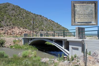
San Luis Bridge is a reinforced concrete structure that crosses Culebra Creek using a single-span open spandrel arch design. The structure measures approximately 62 feet in length and 14 feet in width and was built to accommodate foot traffic and cyclists.

The bridge was built in 1911 by M.F. Levy Construction Company under the supervision of Colorado's State Engineer. It gained recognition in 1985 when added to the National Register of Historic Places.

The bridge reflects how early engineers solved transportation needs in rural Colorado communities. It represents an important connection project that linked the town to surrounding areas.

The bridge is best explored on foot or by bicycle and offers good accessibility for both modes of travel. The structure has undergone comprehensive restoration work that ensures a safe and stable crossing.

The structure is among the earliest and least modified examples of its construction type across Colorado. This design approach was later copied often, but few bridges from this era remain as well preserved as this one.

Location: San Luis

GPS coordinates: 37.19361,-105.43028

Latest update: December 6, 2025 17:48

Photos
Remarkable bridges around the world

This collection gathers bridges and engineering structures that mark the history of modern infrastructure worldwide. Structures such as the Akashi-Kaikyo Bridge in Japan, with its span of 3,911 meters, or the 37-kilometer Chesapeake Bay Bridge-Tunnel in Virginia demonstrate technological advances made to cross natural obstacles. These include suspension bridges, cable-stayed bridges, and viaducts that often set records for length or height. From the Confederation Bridge linking Prince Edward Island to New Brunswick in extreme weather conditions, to the Øresund Bridge connecting Denmark and Sweden, these structures change the geography and facilitate exchanges between regions. The Vasco da Gama Bridge in Lisbon, the Norman Bridge crossing the Seine at Honfleur, or the Yavuz Sultan Selim Bridge in Istanbul illustrate how modern engineering addresses transportation needs while adapting to each site's geographic constraints.

Around this place
Show the full map
Blanca Peak
United States of America

Blanca Peak

43 km
Spanish Peaks
United States of America

Spanish Peaks

45.2 km
Zapata Falls
United States of America

Zapata Falls

48.6 km
Spanish Peaks Wilderness
United States of America

Spanish Peaks Wilderness

45.2 km
Rio Grande Scenic Railroad
United States of America

Rio Grande Scenic Railroad

49 km
Culebra Peak
United States of America

Culebra Peak

23.1 km
West Spanish Peak
United States of America

West Spanish Peak

43.7 km
Fort Garland
United States of America

Fort Garland

25.6 km
Little Bear Peak
United States of America

Little Bear Peak

41.9 km
Mount Lindsey
United States of America

Mount Lindsey

43.5 km
Alamosa National Wildlife Refuge
United States of America

Alamosa National Wildlife Refuge

38.8 km
Latir Peak Wilderness
United States of America

Latir Peak Wilderness

44.3 km
Ellingwood Point
United States of America

Ellingwood Point

43.6 km
Pike's Stockade
United States of America

Pike's Stockade

35.4 km
D&RGW 169
United States of America

D&RGW 169

49 km
San Luis Hills
United States of America

San Luis Hills

27.8 km
Closed Basin Project
United States of America

Closed Basin Project

45.1 km
St. Thomas Episcopal Church
United States of America

St. Thomas Episcopal Church

49.3 km
Red Mountain
United States of America

Red Mountain

23.9 km
A. A. Salazar House
United States of America

A. A. Salazar House

1.1 km
American National Bank Building
United States of America

American National Bank Building

49.1 km
Rito Seco Creek Culvert
United States of America

Rito Seco Creek Culvert

801 m
San Luis Southern Railway Trestle
United States of America

San Luis Southern Railway Trestle

23.9 km
Alamosa County Courthouse
United States of America

Alamosa County Courthouse

49.3 km
Husung Hardware
United States of America

Husung Hardware

49.2 km
Capilla de San Isidro
United States of America

Capilla de San Isidro

7.9 km
Monument Lake Park Building and Hatchery Complex
United States of America

Monument Lake Park Building and Hatchery Complex

34 km
Costilla Crossing Bridge
United States of America

Costilla Crossing Bridge

31.7 km
Show the full map
Reviews

Visited this place? Tap the stars to rate it and share your experience / photos with the community! Try now! You can cancel it anytime.

« San Luis Bridge - Historic bridge in San Luis, United States » is provided by Around Us (aroundus.com). Images and texts are derived from Wikimedia project under a Creative Commons license. You are allowed to copy, distribute, and modify copies of this page, under the conditions set by the license, as long as this note is clearly visible.

Discover hidden gems everywhere you go!

From secret cafés to breathtaking viewpoints, skip the crowded tourist spots and find places that match your style. Our app makes it easy with voice search, smart filtering, route optimization, and insider tips from travelers worldwide. Download now for the complete mobile experience.

Around Us App Screenshot

A unique approach to discovering new places

Le Figaro

All the places worth exploring

France Info

A tailor-made excursion in just a few clicks

20 Minutes