Enable Location

We need your location to show you interesting places around you

Discover nearby places

Find interesting locations and hidden gems around you

Precise directions

Get accurate directions and distances to places

Your location is never shared with other users. It's only used when you tap the location button.

Núi Thành

Log in to your account

Start exploring — it's free

Trusted by 62,058 travelers worldwide

Continue with Google
Continue with Apple
or

We will send you a code to connect

By continuing, you accept our Terms and Conditions and our Privacy Policy

Check your inbox

We've sent a pincode in your inbox. Please enter the code below.

Núi Thành

Núi Thành, Rural district in Quảng Nam province, Vietnam

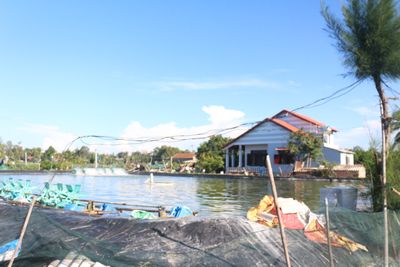
Núi Thành is a rural district on central Vietnam's coast, combining farmland, residential areas, and industrial zones across its expanse. The region spreads over multiple communes and a central town that serve as administrative hubs.

The district was established in 1983 as a separate administrative unit, emerging from the reorganization of a larger former district in the province. This restructuring reflected broader administrative changes taking place in the region during that era.

The district maintains traditional Vietnamese farming practices while incorporating modern agricultural techniques across its sixteen rural communes and central town.

The area connects to major cities through an airport nearby that handles regular flights to larger urban centers. Visitors should plan ahead to arrange transportation into this rural district and navigate its different communes.

Along the coast sits a major gas storage facility that plays an important role in powering central Vietnam's economy. This installation stands near a fishing port that once functioned as a military airfield.

The community of curious travelers

AroundUs brings together thousands of curated places, local tips, and hidden gems, enriched daily by 60,000 contributors worldwide.

Start exploring
Location
Elevation above the sea
32 m
GPS coordinates
15.43450,108.64727
Latest update
December 7, 2025 20:23
« Núi Thành - Rural district in Quảng Nam province, Vietnam » is provided by Around Us (aroundus.com). Images and texts are derived from Wikimedia project under a Creative Commons license. You are allowed to copy, distribute, and modify copies of this page, under the conditions set by the license, as long as this note is clearly visible.

Discover hidden gems everywhere you go!

From secret cafés to breathtaking viewpoints, skip the crowded tourist spots and find places that match your style. Our app makes it easy with voice search, smart filtering, route optimization, and insider tips from travelers worldwide. Download now for the complete mobile experience.

Around Us App Screenshot

A unique approach to discovering new places

Le Figaro

All the places worth exploring

France Info

A tailor-made excursion in just a few clicks

20 Minutes

Around Us
Travel Guide & Maps
Download

Send to your phone

QR Code
1

Open the camera app on your mobile.

2

Point at the QR code with your camera. A notification will appear.

3

Tap the notification to open the link.