See the monuments around you in AROpen chests in the app
Around Us is built for your phone — point your camera at the streets and discover the monuments and places around you in augmented reality.Around Us is built for your phone — chests unlock when you walk, explore and capture nearby places.
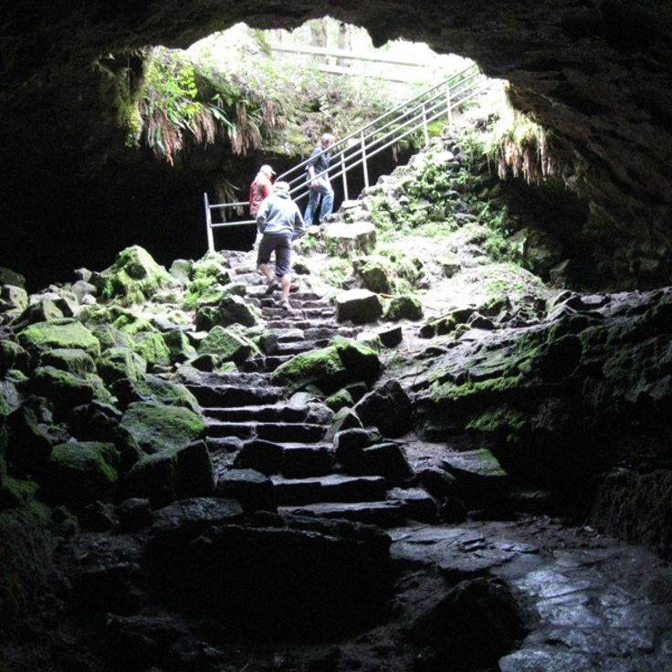
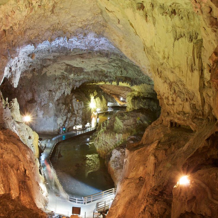
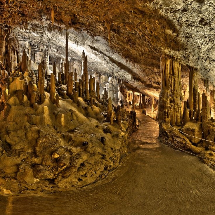
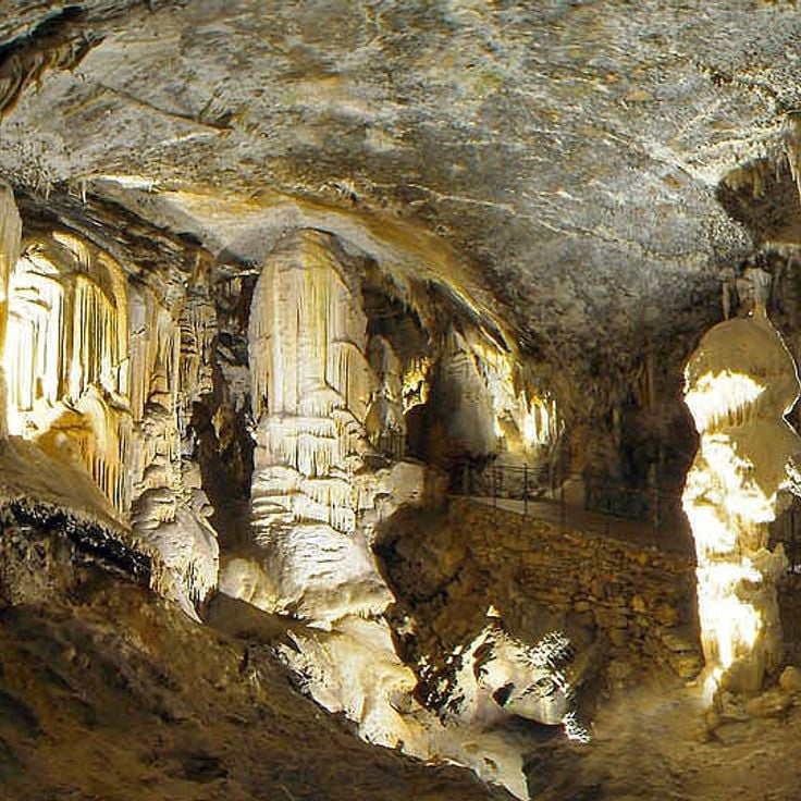
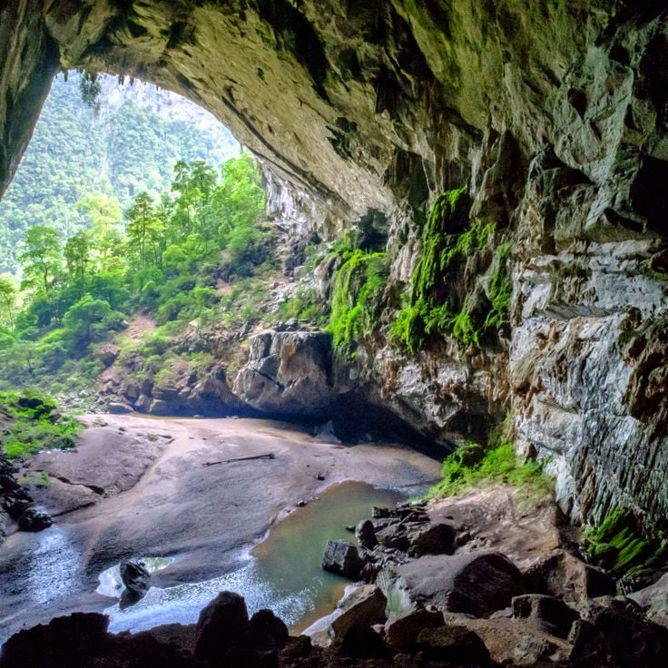
The most beautiful caves and grottoes in the World
Caves form through gradual geological processes that can span millions of years. Water dissolves limestone and creates underground chambers filled with stalactites and stalagmites, while ice caves in alpine regions maintain their frozen formations even during summer months. Each cave system tells a distinct story about the forces that shaped it, from chemical erosion to tectonic shifts that exposed new rock layers to underground rivers.
This collection includes some of the most geologically significant caves on Earth. Carlsbad Caverns in New Mexico encompasses more than 30 miles (48 kilometers) of passages filled with mineral formations, while Mammoth Cave in Kentucky extends over 400 miles (650 kilometers) through limestone bedrock. Eisriesenwelt in Austria stretches 26 miles (42 kilometers) and contains ice structures that reform each winter. Reed Flute Cave in Guilin showcases limestone formations that began developing 180 million years ago. Waitomo Caves in New Zealand are home to thousands of glowworms that light the darkness with bioluminescence. Puerto Princesa in the Philippines features an underground river that flows 5 miles (8 kilometers) before reaching the sea. Several caves also preserve human history, including Lascaux in France with its 17,000-year-old paintings. These formations demonstrate how water, ice, and time create underground worlds that reveal both geological and cultural history.
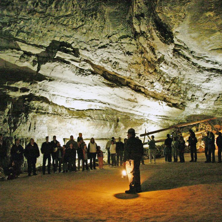
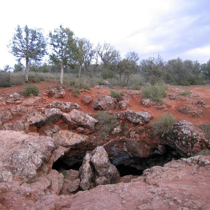
This underground network extends across three levels and comprises 119 caves containing extensive limestone formations. The system provides insight into geological processes that developed over millions of years. The chambers contain stalactites, stalagmites, and other speleothems formed through mineral deposits. A large bat colony inhabits portions of the caves and exits the entrances at sunset. The Carlsbad Caverns reach depths exceeding 1,000 feet (305 meters) below ground level and display various stages of cave development.
Reed Flute Cave is a 240-meter (787-foot) limestone cave in Guilin that has been visited for over 1,200 years. This component of the worldwide collection of natural caves displays stalagmites, stalactites, and rock formations highlighted by LED lighting. The cave contains over 70 inscriptions from the Tang Dynasty on its walls. The system leads through several chambers with names that reference the shapes of formations. The cave formed through water erosion of limestone during the Carboniferous period.
This limestone cave in Krabi contains natural thermal springs and a mineral-rich water basin with green coloration. The geological formation developed through thousands of years of limestone deposits and provides an example of underground structures created by chemical processes within the rock. The thermal springs inside the cave maintain consistent temperatures, and the water contains various minerals that contribute to its characteristic color. Krabi Cave represents one of Thailand's geological formations shaped by erosion and mineral deposits, offering visitors access to underground water systems and examples of limestone cave development in tropical regions.
This cave in Kentucky is among the longest known cave systems in the world, extending over 400 miles (650 kilometers) of underground passages. Mammoth Cave contains underground rivers that wind through limestone formations, as well as prehistoric mineral mining sites that indicate use by earlier cultures. The extensive network includes various geological sections with dripstone formations, canyons, and chambers that were shaped by water erosion over millions of years. The cave provides insight into geological processes and the history of human activity in underground environments.
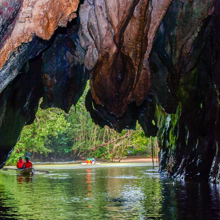
This underground river extends 5.1 miles (8.2 kilometers) through a cave system on Palawan before flowing into the South China Sea. The geological network contains calcite formations that have developed over thousands of years. The Puerto Princesa Subterranean River forms part of this collection of natural caves and underground formations, demonstrating karst erosion processes in tropical regions. The system includes multiple chambers with stalactites and stalagmites, while the river flows through limestone covered by rainforest above.
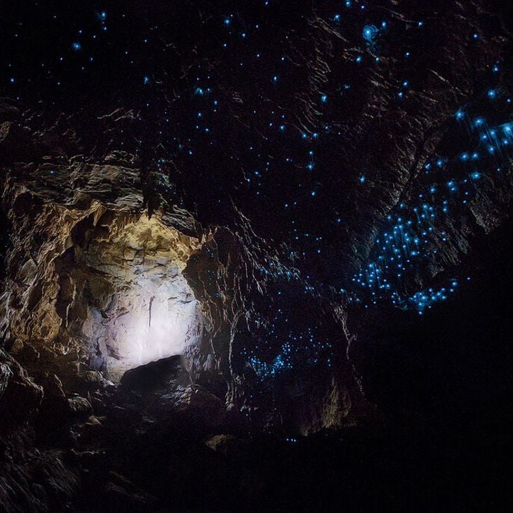
The Waitomo Glowworm Caves are part of the underground world of natural caves and house thousands of Arachnocampa luminosa larvae that illuminate the cave ceilings with their blue light. These limestone caves on the North Island of New Zealand formed approximately 30 million years ago through tectonic activity and erosion. The bioluminescent larvae hang from the ceiling on silky threads and create a glowing display that attracts insects. Visitors can explore the caves on foot or by boat through the underground waterways, where the illuminated ceilings resemble a starry sky. The caves include several chambers with stalactites, stalagmites, and other limestone formations.
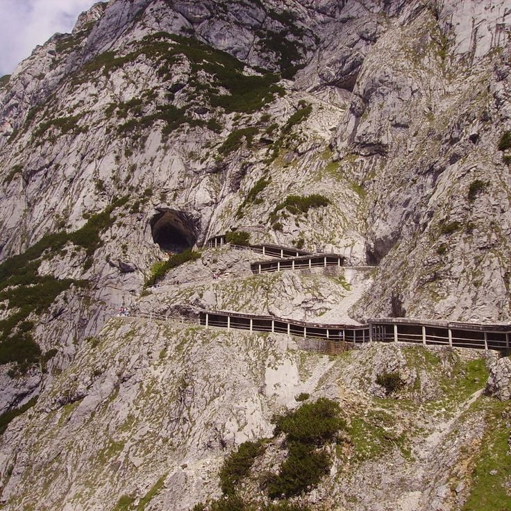
This ice cave forms a significant geological system in the Alps, with formations that remain frozen throughout the year. Eisriesenwelt extends 42 kilometers (26 miles), with natural ice structures covering 30,000 square meters (323,000 square feet). The system formed through the entry of cold winter air that transforms meltwater into crystalline structures. The cave displays ice curtains, frozen waterfalls, and ice formations several meters high that gain their distinctive coloring from calcium carbonate and rock particles. This underground system lies within the Tennen Mountains and ranks among the largest ice caves worldwide.
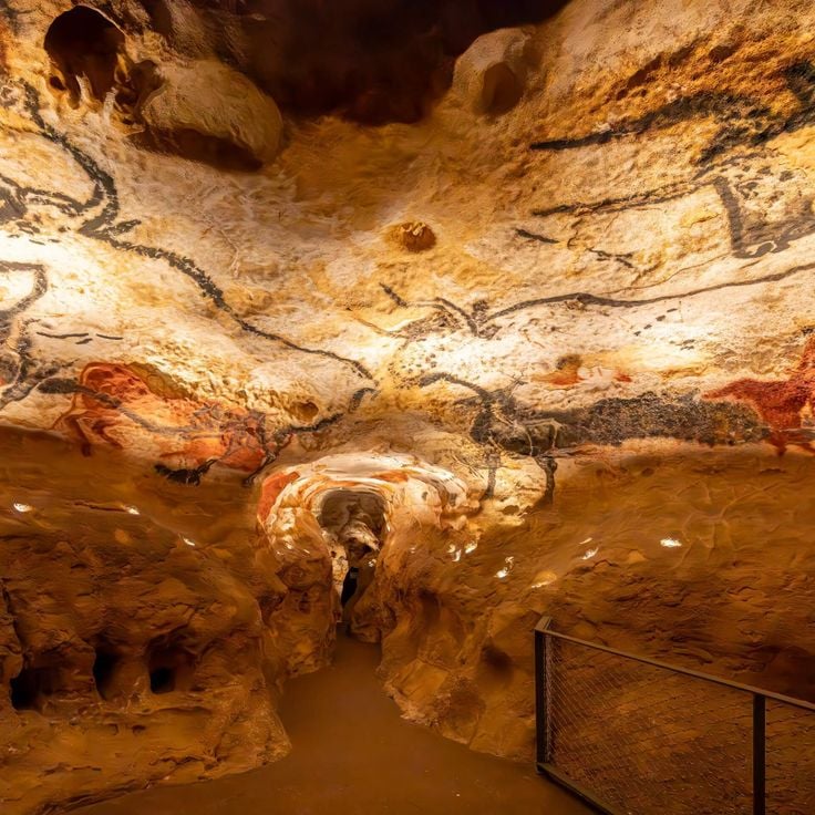
Lascaux Cave contains approximately 2000 prehistoric figures painted around 17000 years ago. The walls display large murals of aurochs, horses, and deer. This rock art represents one of the most significant examples of human creativity from the Paleolithic period and provides insight into the lifestyle and symbolic world of the hunters and gatherers who inhabited southwestern France during that time.
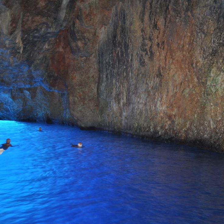
This natural sea cave on Capri receives its glowing blue color from sunlight entering through an underwater opening that illuminates the water in turquoise tones. The Blue Grotto is one of Italy's most recognized coastal caves and belongs to the underground formations created by geological processes over thousands of years. Access is possible during calm seas using small boats that must duck through the low entrance. The phenomenon of blue reflection occurs through light refraction in the clear seawater.
This cave measures 574 feet (174 meters) in height and 440 feet (134 meters) in width and houses millions of bats of different species. Deer Cave is part of an extensive limestone cave system in Borneo formed through geological processes over thousands of years. The large dimensions of the cave support massive bat colonies that emerge in dense formations at sunset. The cave represents a significant underground formation that combines both geological and biological features and ranks among the largest cave passages in the world.
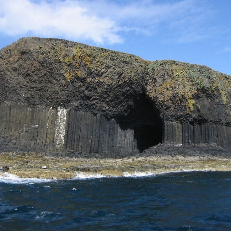
This cave on Staffa features hexagonal basalt columns that rise approximately 60 feet (18 meters) above the sea and create natural acoustics. The movement of ocean waves through the cave opening produces complex harmonic sounds that gave the location its Gaelic name. The basalt formations resulted from rapid cooling of lava around 60 million years ago. Access is by boat during calm weather, and the cave extends roughly 250 feet (75 meters) into the cliff face. The geometric structure of the columns forms natural arches and vaults that are part of the volcanic formation of the Hebrides.
The Crystal Cave is an underground formation on South Bass Island near Put-in-Bay, part of the collection of geological structures worldwide. This cave houses celestine geodes with crystals reaching lengths up to 18 inches (45 centimeters). The cave was discovered in 1897 during well-digging operations and sits approximately 40 feet (12 meters) below the surface. The bluish-tinted celestine crystals grow within hollow geodes embedded in limestone layers. This geological formation developed through mineral-rich solutions that shaped the crystal structures over thousands of years.
Lechuguilla Cave contains rare mineral formations, including gypsum deposits in various forms such as needles, hair, and crystals. The protected underground ecosystem of this cave harbors unique microorganisms that exist in the extreme environment without sunlight. Extending to depths exceeding 1,600 feet (488 meters) and with a total length of more than 138 miles (222 kilometers), this cave ranks among the longest and deepest caves in the United States. The formation developed through sulfuric acid dissolving the limestone, resulting in unusual geological structures that differ from typical drip stone caves.
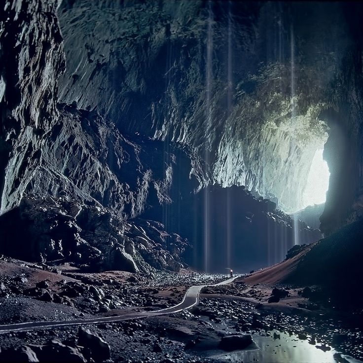
This cave extends for 3 miles (5 kilometers) through Quảng Bình Province and contains chambers with heights equivalent to a 40-story building. The geological formation developed approximately 2 to 5 million years ago through water erosion of limestone bedrock and constitutes one of the largest known cave passages in the world. Inside the cave are an underground river, collapsed ceiling sections that create natural skylights, and stalagmite formations of extraordinary dimensions. The cave was discovered only in 1991 and remains a significant example of underground limestone formations in this collection of geological structures.
These caves formed through 6000 years of water erosion in limestone and sit directly above Lake General Carrera in Chilean Patagonia. The Marble Caves display swirling formations with shades of blue, gray, and turquoise colored by the lake's mineral-rich glacial water. The erosion patterns have created smooth, undulating walls and ceilings that reflect light. These geological structures are accessible only by boat, and the colors vary with water levels and seasons. The caves lie near the Argentine border in a remote area of the Patagonian Andes. Ongoing erosion continues to reshape the chambers and passageways.
The Naracoorte Caves contain one of the most important fossil deposits from the Pleistocene era in Australia. Within these limestone caverns lie bones and remains of marsupials and extinct megafauna that inhabited the region several hundred thousand years ago. The fossil deposits provide insight into the prehistoric animal life of the southern Australian continent. These geological formations are part of a network of underground structures with scientific importance for the study of Quaternary mammals. The caves document the life and extinction of large animal species during climatic changes of the ice age.
This nine kilometer limestone cave contains underground rivers, stalactites, and stalagmites. Akiyoshido Cave sits within a karst landscape and was formed through the erosion of limestone over millions of years. Visitors can explore approximately one kilometer of the cave along concrete pathways, while the remainder is accessible only to researchers. The cave displays various formations including the large main chamber with stalagmites reaching several meters in height and flowing water that runs through the underground system. The temperature inside the cave remains around 62 degrees Fahrenheit (17 degrees Celsius) throughout the year.
These caves form a karst river system where the Reka River flows through a 2.2 mile (3.5 kilometer) underground canyon that reaches depths of 460 feet (140 meters) in some sections. The system developed over millions of years as water dissolved limestone bedrock, creating chambers that rise up to 490 feet (150 meters) in height. Škocjan Caves contain active watercourses and geological formations including stalagmites and stalactites that continue to develop as the river transports material through the canyon.
This cave in Postojna extends 15 miles (24 kilometers) through limestone formations that developed over two million years. The system contains stalactites and stalagmites formed through continuous deposition of calcium carbonate, along with an underground river that continues to shape the chambers. The cave hosts the olm, a blind cave dweller completely adapted to life in total darkness. Visitors ride an electric train through the main galleries before walking through sections that demonstrate various geological processes shaping karst landscapes.
This cave is named for the swallow population it shelters and ranks as the third largest cave system in Vietnam, with a main chamber measuring 400 feet (120 meters) wide and 260 feet (80 meters) tall. Hang Én sits in Quảng Bình Province and was discovered in 1994. The cave contains underground rivers, sinkholes and limestone geological formations that developed through water erosion over millions of years.
This limestone cave system in Keserwan District extends across two levels along the Nahr al-Kalb River, with an upper gallery measuring roughly 1.2 miles (2 kilometers) and a lower water-filled cave that visitors explore by boat, stretching approximately 4 miles (6 kilometers) into the mountain, where geological processes spanning millions of years have created stalactites, stalagmites and crystalline formations that make this one of the most geologically significant cave systems in the Middle East.
This Hindu temple complex in limestone caves north of Kuala Lumpur contains several shrines dedicated to the deity Murugan. The caves formed approximately 400 million years ago, and the main cave is reached by climbing 272 steps. The site became a place of Hindu pilgrimage in the late 19th century and attracts several hundred thousand devotees during the Thaipusam festival. The Cathedral Cave rises 330 feet (100 meters) above ground level and contains various shrines set within natural chambers. The limestone formation developed through geological processes that dissolved rock over millions of years through rainwater.
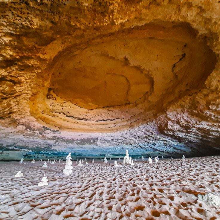
This sea cave along the Algarve coast formed through centuries of erosion as Atlantic waves carved the limestone cliffs and created a natural dome with a circular opening to the sky. The Algar de Benagil is accessible only from the water and demonstrates the geological processes that shaped Portugal's coastline. The cave contains a small sand beach and rock formations that amplify the play of light through the ceiling aperture.
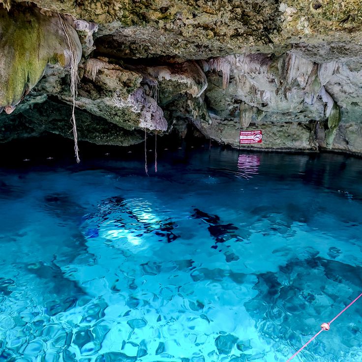
This cenote sits in jungle terrain near the coast of Tulum and formed through the collapse of limestone ceilings that exposed freshwater chambers below. Tak Be Ha reaches depths of around 43 feet (13 meters) and provides access to branching cave systems that extend through the Yucatán Peninsula. The clear water allows visibility of limestone formations and roots descending from above, while natural light filters through the opening into the main chamber.
These caves on Mallorca's eastern coast extend 1,200 meters (3,900 feet) through limestone formations that developed over thousands of years through water erosion. The Coves del Drach contain four interconnected underground lakes, including Lake Martel, one of the largest subterranean lakes in Europe at 177 meters (580 feet) in length. The cave system was explored and mapped in the late 19th century and demonstrates the geological processes that create stalactites and stalagmites. This formation shows how water dissolves limestone over time to create underground chambers, similar to other geologically significant cave systems worldwide.
The Cango Caves extend 2.5 miles (4 kilometers) through Precambrian limestone north of Oudtshoorn and rank among the most geologically significant cave systems in Africa. These caves formed through millions of years of chemical erosion and contain massive dripstone formations, including 30-foot (9-meter) stalagmites in Van Zyl's Hall and extensive flowstone terraces. The system consists of several interconnected chambers, with Cango One accessible to visitors and featuring passages that reach heights of 52 feet (16 meters). Archaeological evidence documents human occupation dating back approximately 80,000 years by the San people, whose tools and rock paintings remain preserved in certain sections. The caves now serve as a geological textbook demonstrating the process of limestone dissolution and mineral deposition in South African sedimentary rock.
This cave near Beit Shemesh contains stalactites and stalagmites that formed over thousands of years through limestone dissolution. The underground system was discovered in 1968 during quarry work and now operates as a show cave that documents the region's geological processes and provides insight into how such formations develop.
This cave in Spain's Albacete province extends approximately 295 feet (90 meters) deep and is known for its literary connection to Miguel de Cervantes' Don Quixote. The Cueva de Montesinos consists of limestone formations that developed over geological time periods and features several underground chambers with mineral deposits. Visitors descend into the main shaft via a series of steps, where they can observe stalactites and other erosion structures typical of karst landscapes.
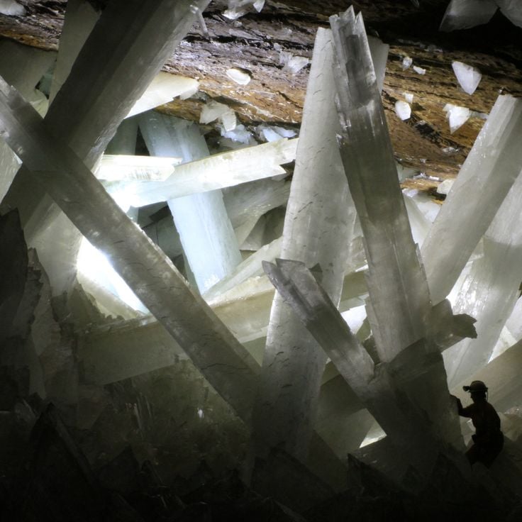
This cave in the Naica Mine contains some of the largest natural crystals discovered anywhere on Earth. The selenite columns reach lengths exceeding 36 feet (11 meters) and formed as mineral-rich water circulated through the chamber for over 500,000 years. Temperatures in the cave remain constant at around 122 degrees Fahrenheit (50 degrees Celsius) with near-complete humidity, making extended stays impossible without protective equipment.
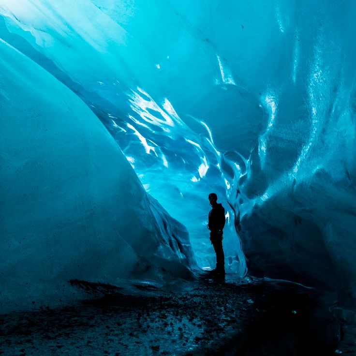
This glacier cave in Vatnajökull National Park forms as meltwater carves tunnels through the ice. The walls display layers of compressed snow and volcanic ash deposited over centuries. Like other major caves in this collection, Vatnajökull demonstrates geological processes that create underground formations—here through ice movement rather than chemical erosion. The cave changes with each season as temperature fluctuations and glacier motion reshape its structure.
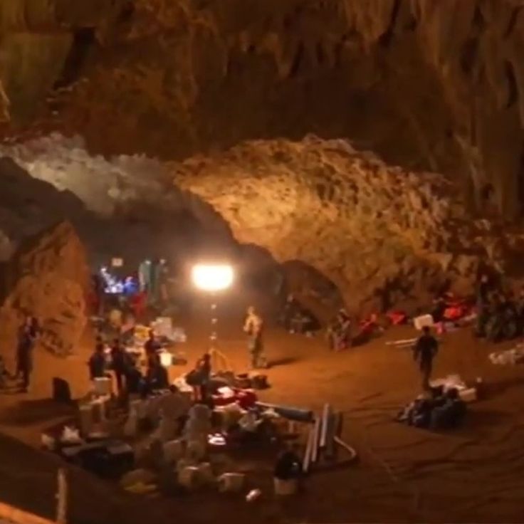
This cave system in northern Thailand extends roughly 6 miles (10 kilometers) through limestone formations near the Myanmar border and connects several chambers through partially flooded passages that often become impassable during monsoon season, showing geological processes that have been shaping the rock for millions of years.
This lava tube in Mount St. Helens National Volcanic Monument in Washington formed about 2,000 years ago when molten rock flowed through volcanic activity. The cave system extends 2.5 miles (4 kilometers) beneath the surface and shows how lava created solidified walls while the liquid interior continued flowing and left hollow tubes. Ape Cave ranks among the longest lava caves in North America and allows visitors to trace the geological processes that shaped these underground structures. The cave preserves volcanic rock in its original state and documents the thermal forces that operated during the eruption.
This underground network extends across three levels and comprises 119 caves containing extensive limestone formations. The system provides insight into geological processes that developed over millions of years. The chambers contain stalactites, stalagmites, and other speleothems formed through mineral deposits. A large bat colony inhabits portions of the caves and exits the entrances at sunset. The Carlsbad Caverns reach depths exceeding 1,000 feet (305 meters) below ground level and display various stages of cave development.
Reed Flute Cave is a 240-meter (787-foot) limestone cave in Guilin that has been visited for over 1,200 years. This component of the worldwide collection of natural caves displays stalagmites, stalactites, and rock formations highlighted by LED lighting. The cave contains over 70 inscriptions from the Tang Dynasty on its walls. The system leads through several chambers with names that reference the shapes of formations. The cave formed through water erosion of limestone during the Carboniferous period.
This limestone cave in Krabi contains natural thermal springs and a mineral-rich water basin with green coloration. The geological formation developed through thousands of years of limestone deposits and provides an example of underground structures created by chemical processes within the rock. The thermal springs inside the cave maintain consistent temperatures, and the water contains various minerals that contribute to its characteristic color. Krabi Cave represents one of Thailand's geological formations shaped by erosion and mineral deposits, offering visitors access to underground water systems and examples of limestone cave development in tropical regions.
This cave in Kentucky is among the longest known cave systems in the world, extending over 400 miles (650 kilometers) of underground passages. Mammoth Cave contains underground rivers that wind through limestone formations, as well as prehistoric mineral mining sites that indicate use by earlier cultures. The extensive network includes various geological sections with dripstone formations, canyons, and chambers that were shaped by water erosion over millions of years. The cave provides insight into geological processes and the history of human activity in underground environments.
This underground river extends 5.1 miles (8.2 kilometers) through a cave system on Palawan before flowing into the South China Sea. The geological network contains calcite formations that have developed over thousands of years. The Puerto Princesa Subterranean River forms part of this collection of natural caves and underground formations, demonstrating karst erosion processes in tropical regions. The system includes multiple chambers with stalactites and stalagmites, while the river flows through limestone covered by rainforest above.
The Waitomo Glowworm Caves are part of the underground world of natural caves and house thousands of Arachnocampa luminosa larvae that illuminate the cave ceilings with their blue light. These limestone caves on the North Island of New Zealand formed approximately 30 million years ago through tectonic activity and erosion. The bioluminescent larvae hang from the ceiling on silky threads and create a glowing display that attracts insects. Visitors can explore the caves on foot or by boat through the underground waterways, where the illuminated ceilings resemble a starry sky. The caves include several chambers with stalactites, stalagmites, and other limestone formations.
This ice cave forms a significant geological system in the Alps, with formations that remain frozen throughout the year. Eisriesenwelt extends 42 kilometers (26 miles), with natural ice structures covering 30,000 square meters (323,000 square feet). The system formed through the entry of cold winter air that transforms meltwater into crystalline structures. The cave displays ice curtains, frozen waterfalls, and ice formations several meters high that gain their distinctive coloring from calcium carbonate and rock particles. This underground system lies within the Tennen Mountains and ranks among the largest ice caves worldwide.
Lascaux Cave contains approximately 2000 prehistoric figures painted around 17000 years ago. The walls display large murals of aurochs, horses, and deer. This rock art represents one of the most significant examples of human creativity from the Paleolithic period and provides insight into the lifestyle and symbolic world of the hunters and gatherers who inhabited southwestern France during that time.
This natural sea cave on Capri receives its glowing blue color from sunlight entering through an underwater opening that illuminates the water in turquoise tones. The Blue Grotto is one of Italy's most recognized coastal caves and belongs to the underground formations created by geological processes over thousands of years. Access is possible during calm seas using small boats that must duck through the low entrance. The phenomenon of blue reflection occurs through light refraction in the clear seawater.
This cave measures 574 feet (174 meters) in height and 440 feet (134 meters) in width and houses millions of bats of different species. Deer Cave is part of an extensive limestone cave system in Borneo formed through geological processes over thousands of years. The large dimensions of the cave support massive bat colonies that emerge in dense formations at sunset. The cave represents a significant underground formation that combines both geological and biological features and ranks among the largest cave passages in the world.
This cave on Staffa features hexagonal basalt columns that rise approximately 60 feet (18 meters) above the sea and create natural acoustics. The movement of ocean waves through the cave opening produces complex harmonic sounds that gave the location its Gaelic name. The basalt formations resulted from rapid cooling of lava around 60 million years ago. Access is by boat during calm weather, and the cave extends roughly 250 feet (75 meters) into the cliff face. The geometric structure of the columns forms natural arches and vaults that are part of the volcanic formation of the Hebrides.
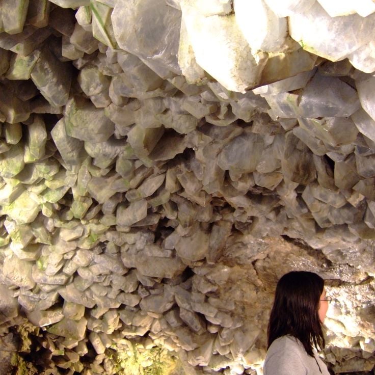
The Crystal Cave is an underground formation on South Bass Island near Put-in-Bay, part of the collection of geological structures worldwide. This cave houses celestine geodes with crystals reaching lengths up to 18 inches (45 centimeters). The cave was discovered in 1897 during well-digging operations and sits approximately 40 feet (12 meters) below the surface. The bluish-tinted celestine crystals grow within hollow geodes embedded in limestone layers. This geological formation developed through mineral-rich solutions that shaped the crystal structures over thousands of years.
Lechuguilla Cave contains rare mineral formations, including gypsum deposits in various forms such as needles, hair, and crystals. The protected underground ecosystem of this cave harbors unique microorganisms that exist in the extreme environment without sunlight. Extending to depths exceeding 1,600 feet (488 meters) and with a total length of more than 138 miles (222 kilometers), this cave ranks among the longest and deepest caves in the United States. The formation developed through sulfuric acid dissolving the limestone, resulting in unusual geological structures that differ from typical drip stone caves.
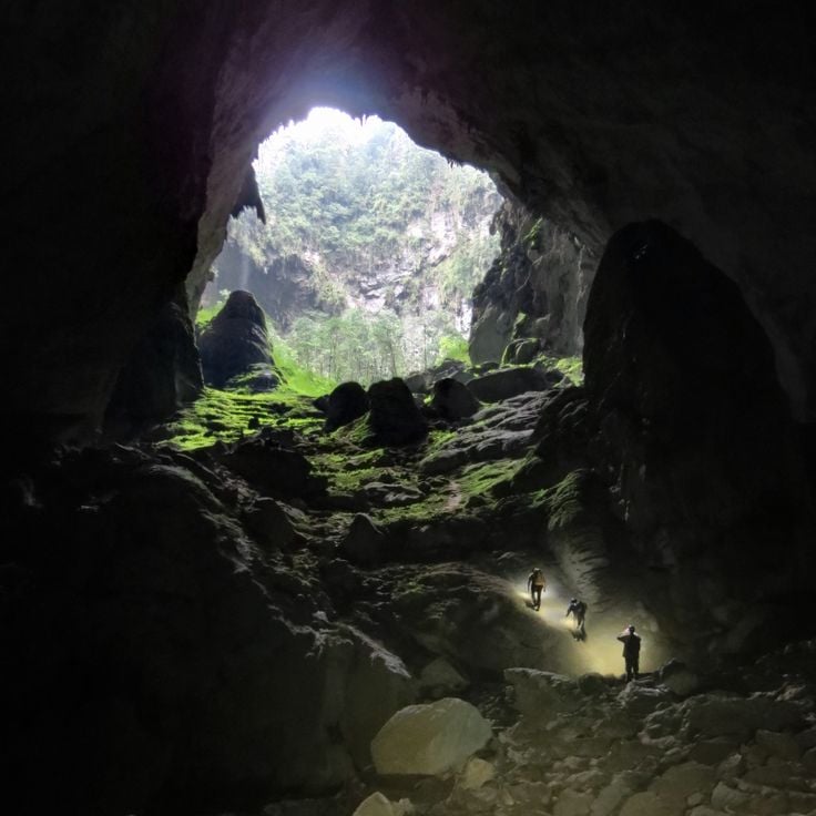
This cave extends for 3 miles (5 kilometers) through Quảng Bình Province and contains chambers with heights equivalent to a 40-story building. The geological formation developed approximately 2 to 5 million years ago through water erosion of limestone bedrock and constitutes one of the largest known cave passages in the world. Inside the cave are an underground river, collapsed ceiling sections that create natural skylights, and stalagmite formations of extraordinary dimensions. The cave was discovered only in 1991 and remains a significant example of underground limestone formations in this collection of geological structures.
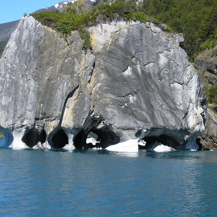
These caves formed through 6000 years of water erosion in limestone and sit directly above Lake General Carrera in Chilean Patagonia. The Marble Caves display swirling formations with shades of blue, gray, and turquoise colored by the lake's mineral-rich glacial water. The erosion patterns have created smooth, undulating walls and ceilings that reflect light. These geological structures are accessible only by boat, and the colors vary with water levels and seasons. The caves lie near the Argentine border in a remote area of the Patagonian Andes. Ongoing erosion continues to reshape the chambers and passageways.
The Naracoorte Caves contain one of the most important fossil deposits from the Pleistocene era in Australia. Within these limestone caverns lie bones and remains of marsupials and extinct megafauna that inhabited the region several hundred thousand years ago. The fossil deposits provide insight into the prehistoric animal life of the southern Australian continent. These geological formations are part of a network of underground structures with scientific importance for the study of Quaternary mammals. The caves document the life and extinction of large animal species during climatic changes of the ice age.
This nine kilometer limestone cave contains underground rivers, stalactites, and stalagmites. Akiyoshido Cave sits within a karst landscape and was formed through the erosion of limestone over millions of years. Visitors can explore approximately one kilometer of the cave along concrete pathways, while the remainder is accessible only to researchers. The cave displays various formations including the large main chamber with stalagmites reaching several meters in height and flowing water that runs through the underground system. The temperature inside the cave remains around 62 degrees Fahrenheit (17 degrees Celsius) throughout the year.
These caves form a karst river system where the Reka River flows through a 2.2 mile (3.5 kilometer) underground canyon that reaches depths of 460 feet (140 meters) in some sections. The system developed over millions of years as water dissolved limestone bedrock, creating chambers that rise up to 490 feet (150 meters) in height. Škocjan Caves contain active watercourses and geological formations including stalagmites and stalactites that continue to develop as the river transports material through the canyon.
This cave in Postojna extends 15 miles (24 kilometers) through limestone formations that developed over two million years. The system contains stalactites and stalagmites formed through continuous deposition of calcium carbonate, along with an underground river that continues to shape the chambers. The cave hosts the olm, a blind cave dweller completely adapted to life in total darkness. Visitors ride an electric train through the main galleries before walking through sections that demonstrate various geological processes shaping karst landscapes.
This cave is named for the swallow population it shelters and ranks as the third largest cave system in Vietnam, with a main chamber measuring 400 feet (120 meters) wide and 260 feet (80 meters) tall. Hang Én sits in Quảng Bình Province and was discovered in 1994. The cave contains underground rivers, sinkholes and limestone geological formations that developed through water erosion over millions of years.
This limestone cave system in Keserwan District extends across two levels along the Nahr al-Kalb River, with an upper gallery measuring roughly 1.2 miles (2 kilometers) and a lower water-filled cave that visitors explore by boat, stretching approximately 4 miles (6 kilometers) into the mountain, where geological processes spanning millions of years have created stalactites, stalagmites and crystalline formations that make this one of the most geologically significant cave systems in the Middle East.
This Hindu temple complex in limestone caves north of Kuala Lumpur contains several shrines dedicated to the deity Murugan. The caves formed approximately 400 million years ago, and the main cave is reached by climbing 272 steps. The site became a place of Hindu pilgrimage in the late 19th century and attracts several hundred thousand devotees during the Thaipusam festival. The Cathedral Cave rises 330 feet (100 meters) above ground level and contains various shrines set within natural chambers. The limestone formation developed through geological processes that dissolved rock over millions of years through rainwater.
This sea cave along the Algarve coast formed through centuries of erosion as Atlantic waves carved the limestone cliffs and created a natural dome with a circular opening to the sky. The Algar de Benagil is accessible only from the water and demonstrates the geological processes that shaped Portugal's coastline. The cave contains a small sand beach and rock formations that amplify the play of light through the ceiling aperture.
This cenote sits in jungle terrain near the coast of Tulum and formed through the collapse of limestone ceilings that exposed freshwater chambers below. Tak Be Ha reaches depths of around 43 feet (13 meters) and provides access to branching cave systems that extend through the Yucatán Peninsula. The clear water allows visibility of limestone formations and roots descending from above, while natural light filters through the opening into the main chamber.
These caves on Mallorca's eastern coast extend 1,200 meters (3,900 feet) through limestone formations that developed over thousands of years through water erosion. The Coves del Drach contain four interconnected underground lakes, including Lake Martel, one of the largest subterranean lakes in Europe at 177 meters (580 feet) in length. The cave system was explored and mapped in the late 19th century and demonstrates the geological processes that create stalactites and stalagmites. This formation shows how water dissolves limestone over time to create underground chambers, similar to other geologically significant cave systems worldwide.
The Cango Caves extend 2.5 miles (4 kilometers) through Precambrian limestone north of Oudtshoorn and rank among the most geologically significant cave systems in Africa. These caves formed through millions of years of chemical erosion and contain massive dripstone formations, including 30-foot (9-meter) stalagmites in Van Zyl's Hall and extensive flowstone terraces. The system consists of several interconnected chambers, with Cango One accessible to visitors and featuring passages that reach heights of 52 feet (16 meters). Archaeological evidence documents human occupation dating back approximately 80,000 years by the San people, whose tools and rock paintings remain preserved in certain sections. The caves now serve as a geological textbook demonstrating the process of limestone dissolution and mineral deposition in South African sedimentary rock.
This cave near Beit Shemesh contains stalactites and stalagmites that formed over thousands of years through limestone dissolution. The underground system was discovered in 1968 during quarry work and now operates as a show cave that documents the region's geological processes and provides insight into how such formations develop.
This cave in Spain's Albacete province extends approximately 295 feet (90 meters) deep and is known for its literary connection to Miguel de Cervantes' Don Quixote. The Cueva de Montesinos consists of limestone formations that developed over geological time periods and features several underground chambers with mineral deposits. Visitors descend into the main shaft via a series of steps, where they can observe stalactites and other erosion structures typical of karst landscapes.
This cave in the Naica Mine contains some of the largest natural crystals discovered anywhere on Earth. The selenite columns reach lengths exceeding 36 feet (11 meters) and formed as mineral-rich water circulated through the chamber for over 500,000 years. Temperatures in the cave remain constant at around 122 degrees Fahrenheit (50 degrees Celsius) with near-complete humidity, making extended stays impossible without protective equipment.
This glacier cave in Vatnajökull National Park forms as meltwater carves tunnels through the ice. The walls display layers of compressed snow and volcanic ash deposited over centuries. Like other major caves in this collection, Vatnajökull demonstrates geological processes that create underground formations—here through ice movement rather than chemical erosion. The cave changes with each season as temperature fluctuations and glacier motion reshape its structure.
This cave system in northern Thailand extends roughly 6 miles (10 kilometers) through limestone formations near the Myanmar border and connects several chambers through partially flooded passages that often become impassable during monsoon season, showing geological processes that have been shaping the rock for millions of years.
This lava tube in Mount St. Helens National Volcanic Monument in Washington formed about 2,000 years ago when molten rock flowed through volcanic activity. The cave system extends 2.5 miles (4 kilometers) beneath the surface and shows how lava created solidified walls while the liquid interior continued flowing and left hollow tubes. Ape Cave ranks among the longest lava caves in North America and allows visitors to trace the geological processes that shaped these underground structures. The cave preserves volcanic rock in its original state and documents the thermal forces that operated during the eruption.
This underground network extends across three levels and comprises 119 caves containing extensive limestone formations. The system provides insight into geological processes that developed over millions of years. The chambers contain stalactites, stalagmites, and other speleothems formed through mineral deposits. A large bat colony inhabits portions of the caves and exits the entrances at sunset. The Carlsbad Caverns reach depths exceeding 1,000 feet (305 meters) below ground level and display various stages of cave development.
Reed Flute Cave is a 240-meter (787-foot) limestone cave in Guilin that has been visited for over 1,200 years. This component of the worldwide collection of natural caves displays stalagmites, stalactites, and rock formations highlighted by LED lighting. The cave contains over 70 inscriptions from the Tang Dynasty on its walls. The system leads through several chambers with names that reference the shapes of formations. The cave formed through water erosion of limestone during the Carboniferous period.
This limestone cave in Krabi contains natural thermal springs and a mineral-rich water basin with green coloration. The geological formation developed through thousands of years of limestone deposits and provides an example of underground structures created by chemical processes within the rock. The thermal springs inside the cave maintain consistent temperatures, and the water contains various minerals that contribute to its characteristic color. Krabi Cave represents one of Thailand's geological formations shaped by erosion and mineral deposits, offering visitors access to underground water systems and examples of limestone cave development in tropical regions.
This cave in Kentucky is among the longest known cave systems in the world, extending over 400 miles (650 kilometers) of underground passages. Mammoth Cave contains underground rivers that wind through limestone formations, as well as prehistoric mineral mining sites that indicate use by earlier cultures. The extensive network includes various geological sections with dripstone formations, canyons, and chambers that were shaped by water erosion over millions of years. The cave provides insight into geological processes and the history of human activity in underground environments.
This underground river extends 5.1 miles (8.2 kilometers) through a cave system on Palawan before flowing into the South China Sea. The geological network contains calcite formations that have developed over thousands of years. The Puerto Princesa Subterranean River forms part of this collection of natural caves and underground formations, demonstrating karst erosion processes in tropical regions. The system includes multiple chambers with stalactites and stalagmites, while the river flows through limestone covered by rainforest above.
The Waitomo Glowworm Caves are part of the underground world of natural caves and house thousands of Arachnocampa luminosa larvae that illuminate the cave ceilings with their blue light. These limestone caves on the North Island of New Zealand formed approximately 30 million years ago through tectonic activity and erosion. The bioluminescent larvae hang from the ceiling on silky threads and create a glowing display that attracts insects. Visitors can explore the caves on foot or by boat through the underground waterways, where the illuminated ceilings resemble a starry sky. The caves include several chambers with stalactites, stalagmites, and other limestone formations.
This ice cave forms a significant geological system in the Alps, with formations that remain frozen throughout the year. Eisriesenwelt extends 42 kilometers (26 miles), with natural ice structures covering 30,000 square meters (323,000 square feet). The system formed through the entry of cold winter air that transforms meltwater into crystalline structures. The cave displays ice curtains, frozen waterfalls, and ice formations several meters high that gain their distinctive coloring from calcium carbonate and rock particles. This underground system lies within the Tennen Mountains and ranks among the largest ice caves worldwide.
Lascaux Cave contains approximately 2000 prehistoric figures painted around 17000 years ago. The walls display large murals of aurochs, horses, and deer. This rock art represents one of the most significant examples of human creativity from the Paleolithic period and provides insight into the lifestyle and symbolic world of the hunters and gatherers who inhabited southwestern France during that time.
This natural sea cave on Capri receives its glowing blue color from sunlight entering through an underwater opening that illuminates the water in turquoise tones. The Blue Grotto is one of Italy's most recognized coastal caves and belongs to the underground formations created by geological processes over thousands of years. Access is possible during calm seas using small boats that must duck through the low entrance. The phenomenon of blue reflection occurs through light refraction in the clear seawater.
This cave measures 574 feet (174 meters) in height and 440 feet (134 meters) in width and houses millions of bats of different species. Deer Cave is part of an extensive limestone cave system in Borneo formed through geological processes over thousands of years. The large dimensions of the cave support massive bat colonies that emerge in dense formations at sunset. The cave represents a significant underground formation that combines both geological and biological features and ranks among the largest cave passages in the world.
This cave on Staffa features hexagonal basalt columns that rise approximately 60 feet (18 meters) above the sea and create natural acoustics. The movement of ocean waves through the cave opening produces complex harmonic sounds that gave the location its Gaelic name. The basalt formations resulted from rapid cooling of lava around 60 million years ago. Access is by boat during calm weather, and the cave extends roughly 250 feet (75 meters) into the cliff face. The geometric structure of the columns forms natural arches and vaults that are part of the volcanic formation of the Hebrides.
The Crystal Cave is an underground formation on South Bass Island near Put-in-Bay, part of the collection of geological structures worldwide. This cave houses celestine geodes with crystals reaching lengths up to 18 inches (45 centimeters). The cave was discovered in 1897 during well-digging operations and sits approximately 40 feet (12 meters) below the surface. The bluish-tinted celestine crystals grow within hollow geodes embedded in limestone layers. This geological formation developed through mineral-rich solutions that shaped the crystal structures over thousands of years.
Lechuguilla Cave contains rare mineral formations, including gypsum deposits in various forms such as needles, hair, and crystals. The protected underground ecosystem of this cave harbors unique microorganisms that exist in the extreme environment without sunlight. Extending to depths exceeding 1,600 feet (488 meters) and with a total length of more than 138 miles (222 kilometers), this cave ranks among the longest and deepest caves in the United States. The formation developed through sulfuric acid dissolving the limestone, resulting in unusual geological structures that differ from typical drip stone caves.
This cave extends for 3 miles (5 kilometers) through Quảng Bình Province and contains chambers with heights equivalent to a 40-story building. The geological formation developed approximately 2 to 5 million years ago through water erosion of limestone bedrock and constitutes one of the largest known cave passages in the world. Inside the cave are an underground river, collapsed ceiling sections that create natural skylights, and stalagmite formations of extraordinary dimensions. The cave was discovered only in 1991 and remains a significant example of underground limestone formations in this collection of geological structures.
These caves formed through 6000 years of water erosion in limestone and sit directly above Lake General Carrera in Chilean Patagonia. The Marble Caves display swirling formations with shades of blue, gray, and turquoise colored by the lake's mineral-rich glacial water. The erosion patterns have created smooth, undulating walls and ceilings that reflect light. These geological structures are accessible only by boat, and the colors vary with water levels and seasons. The caves lie near the Argentine border in a remote area of the Patagonian Andes. Ongoing erosion continues to reshape the chambers and passageways.
The Naracoorte Caves contain one of the most important fossil deposits from the Pleistocene era in Australia. Within these limestone caverns lie bones and remains of marsupials and extinct megafauna that inhabited the region several hundred thousand years ago. The fossil deposits provide insight into the prehistoric animal life of the southern Australian continent. These geological formations are part of a network of underground structures with scientific importance for the study of Quaternary mammals. The caves document the life and extinction of large animal species during climatic changes of the ice age.
This nine kilometer limestone cave contains underground rivers, stalactites, and stalagmites. Akiyoshido Cave sits within a karst landscape and was formed through the erosion of limestone over millions of years. Visitors can explore approximately one kilometer of the cave along concrete pathways, while the remainder is accessible only to researchers. The cave displays various formations including the large main chamber with stalagmites reaching several meters in height and flowing water that runs through the underground system. The temperature inside the cave remains around 62 degrees Fahrenheit (17 degrees Celsius) throughout the year.
These caves form a karst river system where the Reka River flows through a 2.2 mile (3.5 kilometer) underground canyon that reaches depths of 460 feet (140 meters) in some sections. The system developed over millions of years as water dissolved limestone bedrock, creating chambers that rise up to 490 feet (150 meters) in height. Škocjan Caves contain active watercourses and geological formations including stalagmites and stalactites that continue to develop as the river transports material through the canyon.
This cave in Postojna extends 15 miles (24 kilometers) through limestone formations that developed over two million years. The system contains stalactites and stalagmites formed through continuous deposition of calcium carbonate, along with an underground river that continues to shape the chambers. The cave hosts the olm, a blind cave dweller completely adapted to life in total darkness. Visitors ride an electric train through the main galleries before walking through sections that demonstrate various geological processes shaping karst landscapes.
This cave is named for the swallow population it shelters and ranks as the third largest cave system in Vietnam, with a main chamber measuring 400 feet (120 meters) wide and 260 feet (80 meters) tall. Hang Én sits in Quảng Bình Province and was discovered in 1994. The cave contains underground rivers, sinkholes and limestone geological formations that developed through water erosion over millions of years.
This limestone cave system in Keserwan District extends across two levels along the Nahr al-Kalb River, with an upper gallery measuring roughly 1.2 miles (2 kilometers) and a lower water-filled cave that visitors explore by boat, stretching approximately 4 miles (6 kilometers) into the mountain, where geological processes spanning millions of years have created stalactites, stalagmites and crystalline formations that make this one of the most geologically significant cave systems in the Middle East.
This Hindu temple complex in limestone caves north of Kuala Lumpur contains several shrines dedicated to the deity Murugan. The caves formed approximately 400 million years ago, and the main cave is reached by climbing 272 steps. The site became a place of Hindu pilgrimage in the late 19th century and attracts several hundred thousand devotees during the Thaipusam festival. The Cathedral Cave rises 330 feet (100 meters) above ground level and contains various shrines set within natural chambers. The limestone formation developed through geological processes that dissolved rock over millions of years through rainwater.
This sea cave along the Algarve coast formed through centuries of erosion as Atlantic waves carved the limestone cliffs and created a natural dome with a circular opening to the sky. The Algar de Benagil is accessible only from the water and demonstrates the geological processes that shaped Portugal's coastline. The cave contains a small sand beach and rock formations that amplify the play of light through the ceiling aperture.
This cenote sits in jungle terrain near the coast of Tulum and formed through the collapse of limestone ceilings that exposed freshwater chambers below. Tak Be Ha reaches depths of around 43 feet (13 meters) and provides access to branching cave systems that extend through the Yucatán Peninsula. The clear water allows visibility of limestone formations and roots descending from above, while natural light filters through the opening into the main chamber.
These caves on Mallorca's eastern coast extend 1,200 meters (3,900 feet) through limestone formations that developed over thousands of years through water erosion. The Coves del Drach contain four interconnected underground lakes, including Lake Martel, one of the largest subterranean lakes in Europe at 177 meters (580 feet) in length. The cave system was explored and mapped in the late 19th century and demonstrates the geological processes that create stalactites and stalagmites. This formation shows how water dissolves limestone over time to create underground chambers, similar to other geologically significant cave systems worldwide.
The Cango Caves extend 2.5 miles (4 kilometers) through Precambrian limestone north of Oudtshoorn and rank among the most geologically significant cave systems in Africa. These caves formed through millions of years of chemical erosion and contain massive dripstone formations, including 30-foot (9-meter) stalagmites in Van Zyl's Hall and extensive flowstone terraces. The system consists of several interconnected chambers, with Cango One accessible to visitors and featuring passages that reach heights of 52 feet (16 meters). Archaeological evidence documents human occupation dating back approximately 80,000 years by the San people, whose tools and rock paintings remain preserved in certain sections. The caves now serve as a geological textbook demonstrating the process of limestone dissolution and mineral deposition in South African sedimentary rock.
This cave near Beit Shemesh contains stalactites and stalagmites that formed over thousands of years through limestone dissolution. The underground system was discovered in 1968 during quarry work and now operates as a show cave that documents the region's geological processes and provides insight into how such formations develop.
This cave in Spain's Albacete province extends approximately 295 feet (90 meters) deep and is known for its literary connection to Miguel de Cervantes' Don Quixote. The Cueva de Montesinos consists of limestone formations that developed over geological time periods and features several underground chambers with mineral deposits. Visitors descend into the main shaft via a series of steps, where they can observe stalactites and other erosion structures typical of karst landscapes.
This cave in the Naica Mine contains some of the largest natural crystals discovered anywhere on Earth. The selenite columns reach lengths exceeding 36 feet (11 meters) and formed as mineral-rich water circulated through the chamber for over 500,000 years. Temperatures in the cave remain constant at around 122 degrees Fahrenheit (50 degrees Celsius) with near-complete humidity, making extended stays impossible without protective equipment.
This glacier cave in Vatnajökull National Park forms as meltwater carves tunnels through the ice. The walls display layers of compressed snow and volcanic ash deposited over centuries. Like other major caves in this collection, Vatnajökull demonstrates geological processes that create underground formations—here through ice movement rather than chemical erosion. The cave changes with each season as temperature fluctuations and glacier motion reshape its structure.
This cave system in northern Thailand extends roughly 6 miles (10 kilometers) through limestone formations near the Myanmar border and connects several chambers through partially flooded passages that often become impassable during monsoon season, showing geological processes that have been shaping the rock for millions of years.
This lava tube in Mount St. Helens National Volcanic Monument in Washington formed about 2,000 years ago when molten rock flowed through volcanic activity. The cave system extends 2.5 miles (4 kilometers) beneath the surface and shows how lava created solidified walls while the liquid interior continued flowing and left hollow tubes. Ape Cave ranks among the longest lava caves in North America and allows visitors to trace the geological processes that shaped these underground structures. The cave preserves volcanic rock in its original state and documents the thermal forces that operated during the eruption.