See the monuments around you in AROpen chests in the app
Around Us is built for your phone — point your camera at the streets and discover the monuments and places around you in augmented reality.Around Us is built for your phone — chests unlock when you walk, explore and capture nearby places.
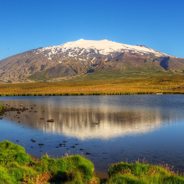
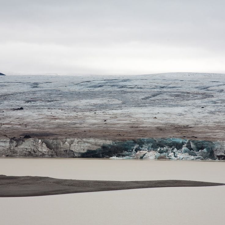
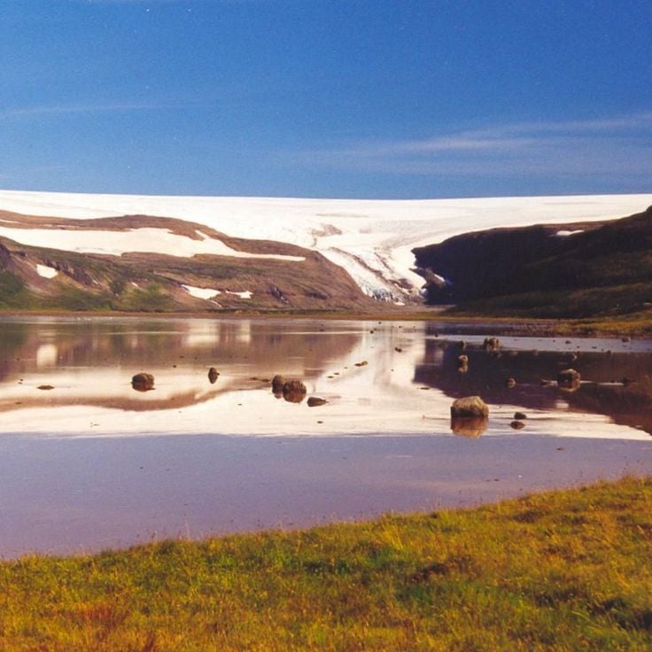
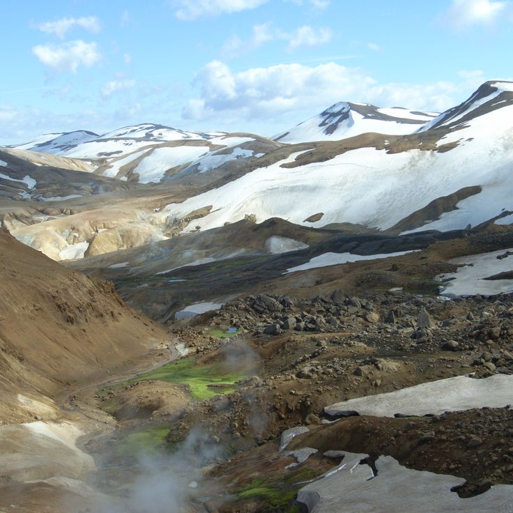
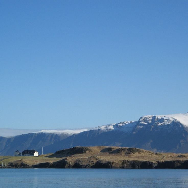
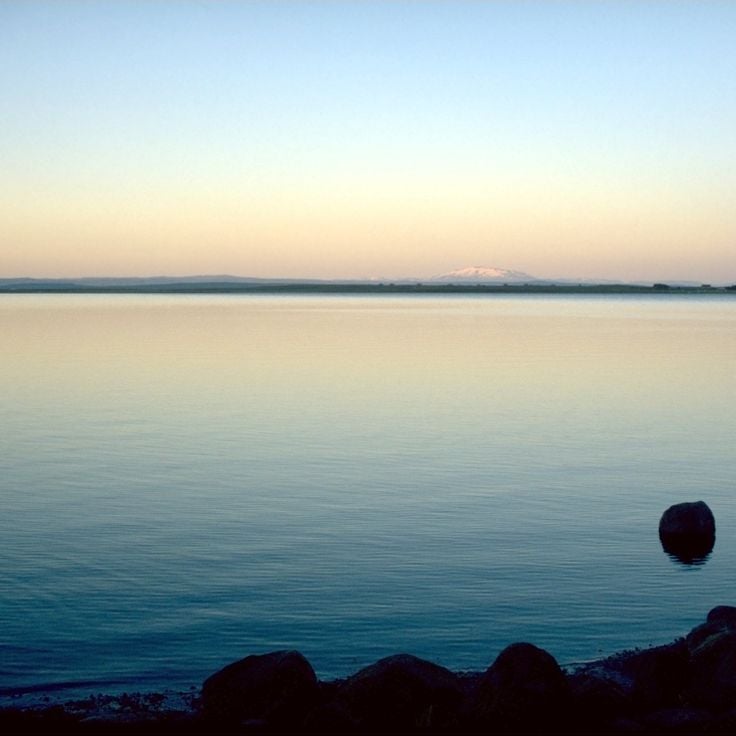
Iceland is an island shaped by ice and fire. Glaciers cover much of the interior while geothermal areas show that something is always happening beneath the surface. The landscapes here look different from most places: black sand beaches formed by volcanic activity, fjords cutting deep into the coast, waterfalls dropping over cliffs and canyons with moss covered walls. Vatnajökull in the southeast is Europe's largest glacier, while smaller ice caps like Snæfellsjökull or Drangajökull have their own character.
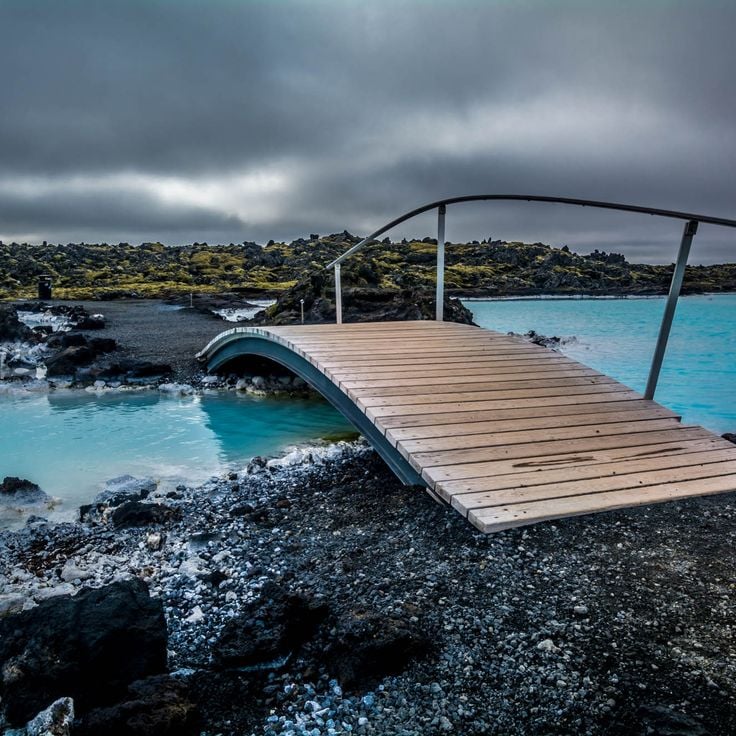
Reykjavik sits by the ocean and mixes city life with access to nature. The Harpa concert hall stands by the harbor, Hallgrímskirkja church rises above the rooftops, and along the shore you find the Sólfar sculpture. Lake Tjörnin lies in the center of town. Outside the city, routes lead to natural sites: the Blue Lagoon with its milky blue water, Strokkur geyser that erupts every few minutes, Gullfoss waterfall where a river plunges into a canyon.
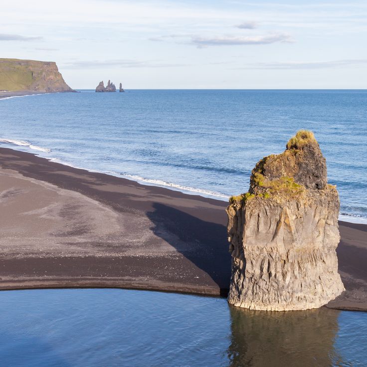
The southern coast shows different faces. Near Vík there is Reynisfjara beach with its basalt columns and black sand, and not far away the cliff at Dyrhólaey. Diamond Beach near Hornafjörður is scattered with ice chunks washed up by the sea. In the north, Lake Mývatn attracts visitors with its volcanic surroundings, while the Westfjords with the Hornstrandir reserve and the red sand of Rauðasandur beach belong to the more remote parts of the country. The Ring Road connects most of these places and circles the entire island.
Iceland is an island shaped by ice and fire. Glaciers cover much of the interior while geothermal areas show that something is always happening beneath the surface. The landscapes here look different from most places: black sand beaches formed by volcanic activity, fjords cutting deep into the coast, waterfalls dropping over cliffs and canyons with moss covered walls. Vatnajökull in the southeast is Europe's largest glacier, while smaller ice caps like Snæfellsjökull or Drangajökull have their own character.
Reykjavik sits by the ocean and mixes city life with access to nature. The Harpa concert hall stands by the harbor, Hallgrímskirkja church rises above the rooftops, and along the shore you find the Sólfar sculpture. Lake Tjörnin lies in the center of town. Outside the city, routes lead to natural sites: the Blue Lagoon with its milky blue water, Strokkur geyser that erupts every few minutes, Gullfoss waterfall where a river plunges into a canyon.
The southern coast shows different faces. Near Vík there is Reynisfjara beach with its basalt columns and black sand, and not far away the cliff at Dyrhólaey. Diamond Beach near Hornafjörður is scattered with ice chunks washed up by the sea. In the north, Lake Mývatn attracts visitors with its volcanic surroundings, while the Westfjords with the Hornstrandir reserve and the red sand of Rauðasandur beach belong to the more remote parts of the country. The Ring Road connects most of these places and circles the entire island.
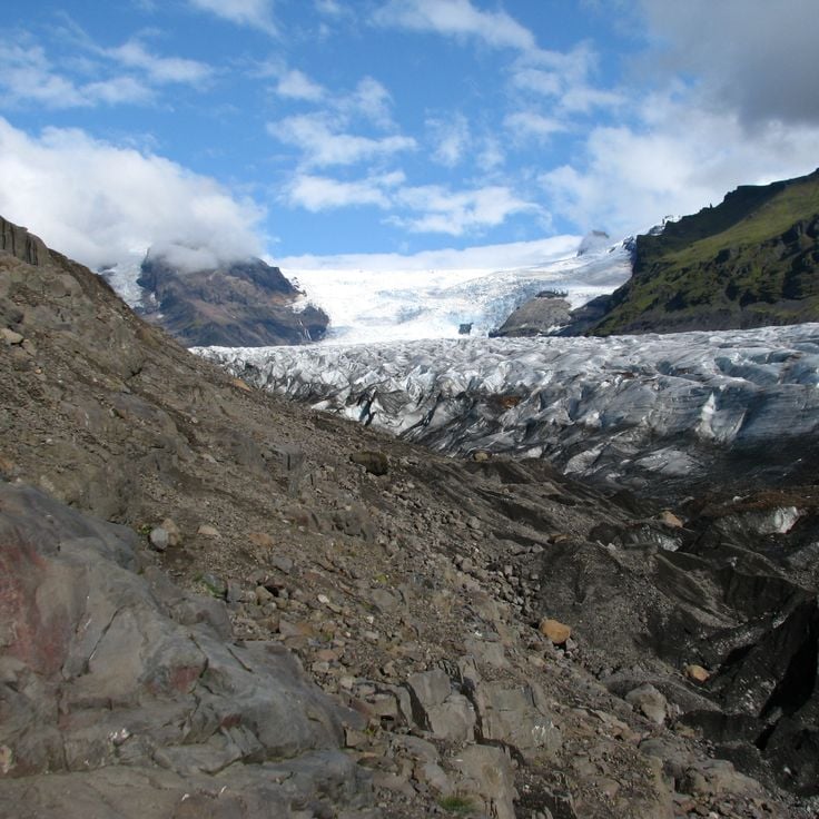
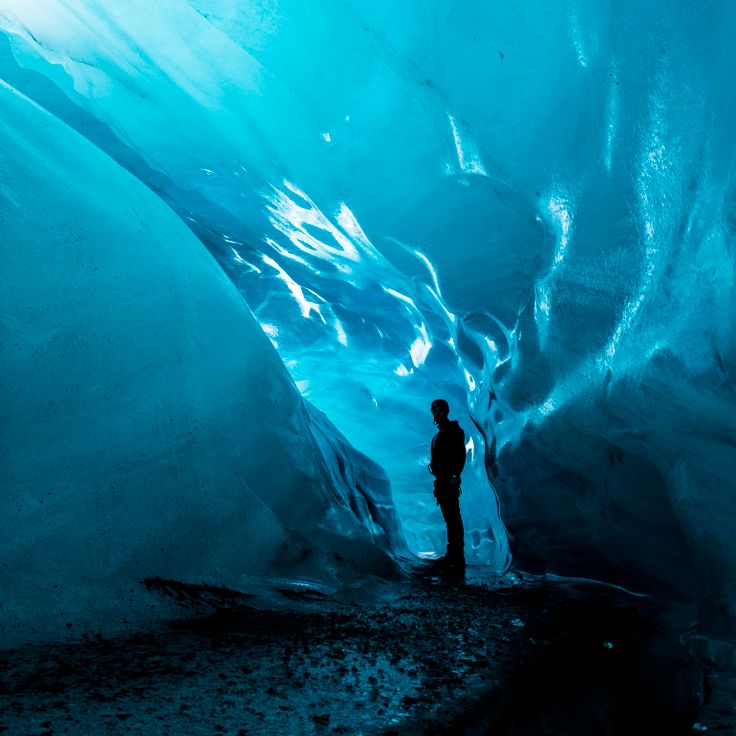
The Vatnajökull spans 8,000 square kilometers (3,100 square miles) and forms ice caves during winter. Active volcanoes lie beneath its surface, occasionally erupting and melting the ice from below. The glacier covers several mountains and valleys in southeastern Iceland and feeds numerous glacial rivers flowing toward the coast. Guided tours provide access to the frozen caverns, where blue ice formations shift each year.
This 1990 sculpture by Jón Gunnar Árnason stands along the Reykjavik waterfront and consists of stainless steel columns that form the outline of a Viking ship. The structure reaches a height of approximately 30 feet (9 meters) and has become a popular photo spot for visitors walking along the bay. The work combines modern materials with Nordic maritime tradition and offers open views across the water. Thousands of travelers stop here each year to experience the coastal setting and the clean lines of the installation.
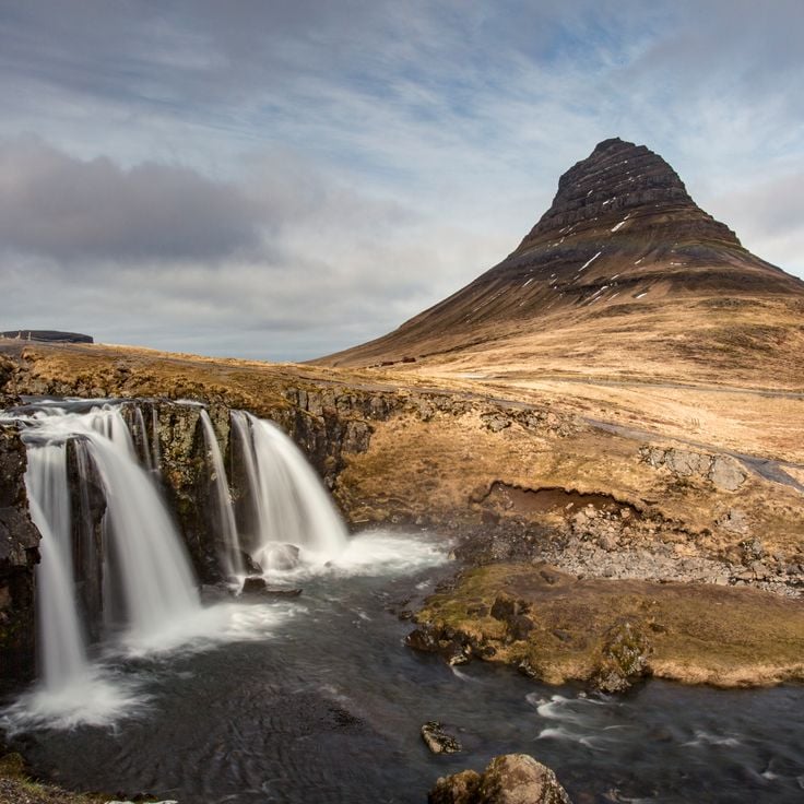
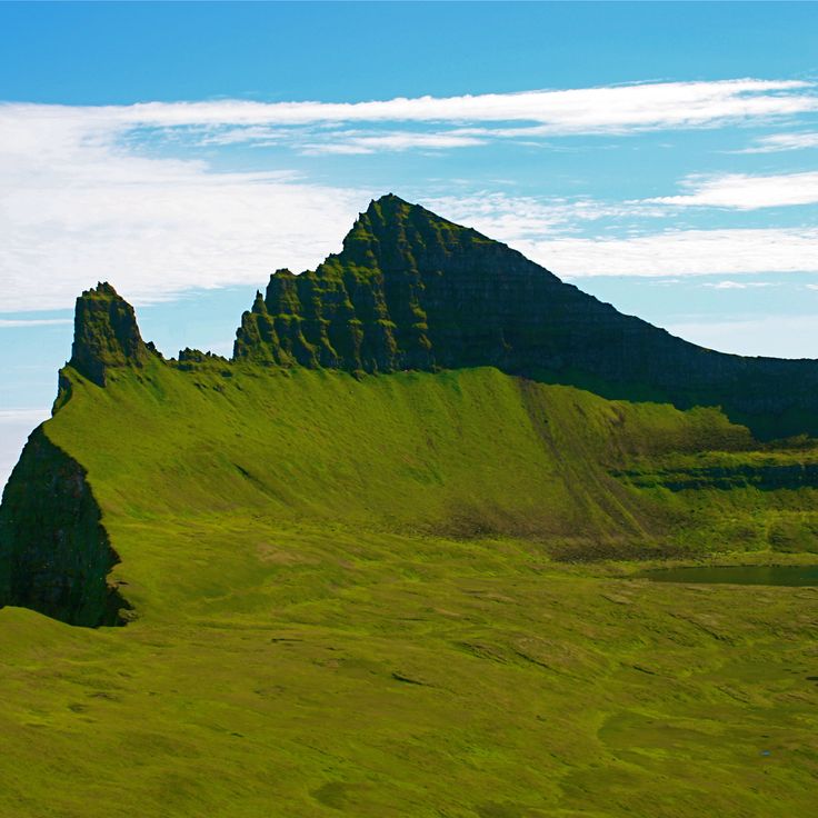
Kirkjufell is a 1,519-foot (463-meter) mountain on the Snæfellsnes Peninsula in western Iceland. Its distinctive cone-shaped profile formed from sedimentary layers of volcanic origin deposited roughly eight million years ago. The mountain sits directly by the sea near the fishing village of Grundarfjörður and is frequently photographed alongside nearby Kirkjufellsfoss waterfall. Hiking trails lead to its summit, though the ascent traverses steep rock slopes and requires secure footing.
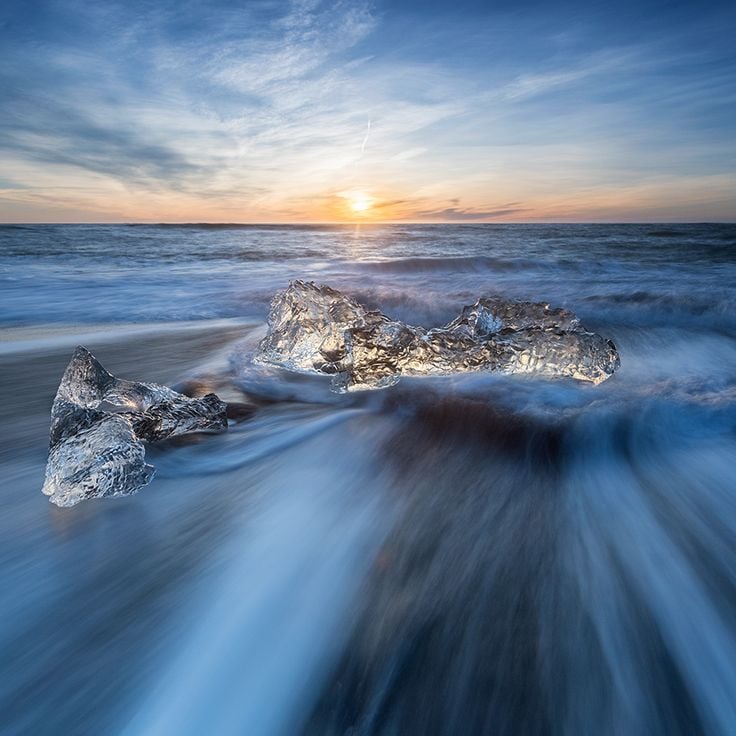
Diamond Beach sits along the Atlantic coast where the glacial lagoon Jökulsárlón meets the ocean. Ice chunks of varying sizes wash ashore and scatter across the black volcanic sand. The blocks break off from the nearby Breiðamerkurjökull glacier and drift through the lagoon before reaching the beach. Light conditions shift throughout the day, causing the ice to glow in shades of blue and white against the dark backdrop. Waves continuously reshape and polish the ice formations. The site is accessible year-round from the Ring Road and draws travelers exploring Iceland's southern glacier region.
Reynisfjara stretches along Iceland's southern coast as one of the country's most recognized landscapes. Black volcanic sand covers the shore, while basalt columns form geometric hexagonal patterns along the cliffs. The Reynisdrangar sea stacks rise from the Atlantic, their appearance shifting with changing light. Basalt caves cut into the formations provide natural alcoves, though the surf here can be unpredictable. Waves often reach considerable heights, and several visitors have been caught by sneaker waves over the years. The beach sits roughly 110 miles east of Reykjavik, accessible via the Ring Road.
The Blue Lagoon is a modern geothermal spa located in the Grindavík region, surrounded by black volcanic rock formations. The mineral-rich water is drawn from a depth of approximately 6500 feet (2000 meters) and maintains a constant temperature of 100 degrees Fahrenheit (38 degrees Celsius). Natural minerals including silica and sulfur form the basis for various treatments and skincare products developed on site. The facility includes multiple pools, a restaurant and a spa complex. Bathing takes place outdoors year-round, with experiences varying by season. Located about 12 miles (20 kilometers) from Keflavík International Airport, the Blue Lagoon ranks among Iceland's most visited destinations.
Snæfellsjökull is an ice cap covering a volcano that has been dormant for approximately 1,750 years. This glacier sits at an elevation of 4,744 feet (1,446 meters), features two summits, and extends across roughly 4.2 square miles (11 square kilometers). The formation serves as a prominent landmark on the Snæfellsnes Peninsula and inspired Jules Verne's novel about a journey to the center of the Earth. Glacier walks require proper equipment and a guide. The surrounding region offers numerous hiking trails and geological features that document Iceland's volcanic history.
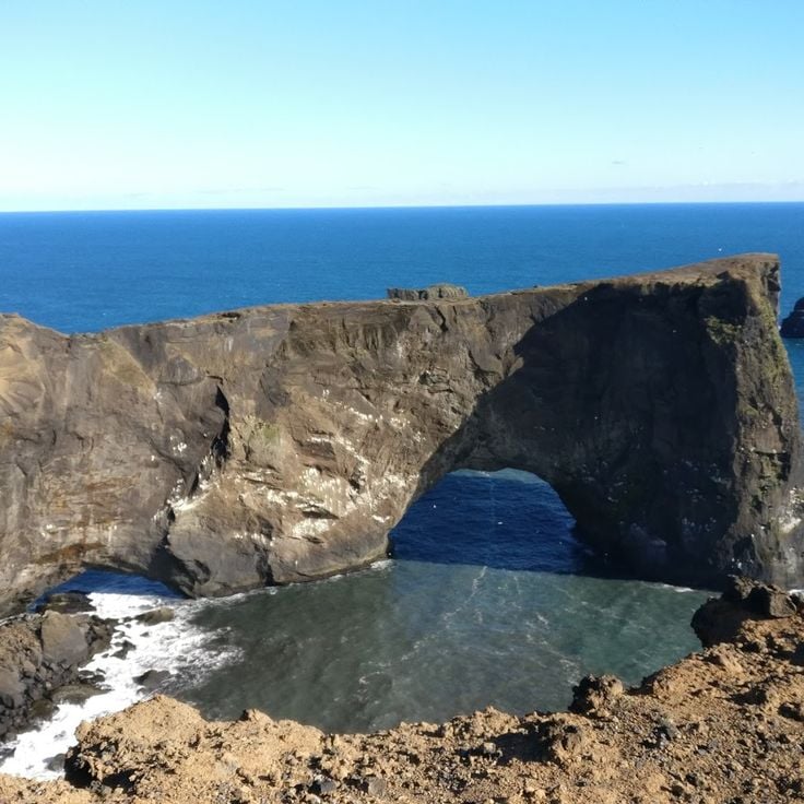
This volcanic headland rises approximately 400 feet above the Atlantic Ocean on Iceland's southern coast and features a natural rock arch large enough for small boats to pass through. Dyrholaey serves as a nesting ground for puffins and other seabirds during the summer months and offers views from its summit over the region's black sand beaches, the ocean and the surrounding cliffs.
The Hornstrandir Nature Reserve occupies the westernmost fjords of Iceland and has been uninhabited since 1950. Arctic foxes roam this wilderness, while seabirds nest on the cliffs and seals frequent the shores. The landscape consists of rugged mountains, deep fjords and steep rock faces accessible only on foot or by boat. Hiking trails cross the reserve, one of the most remote areas in Europe.
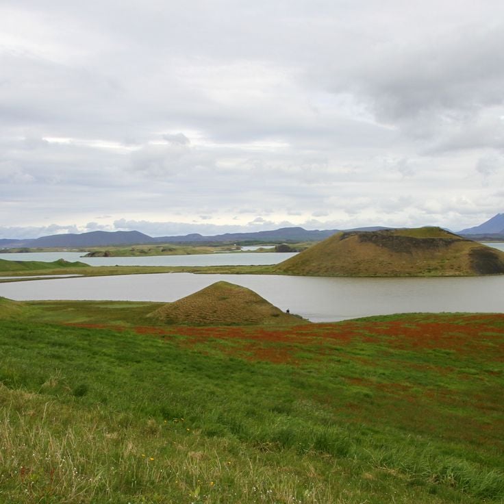
Lake Mývatn is a four-square-mile lake in northern Iceland known for its geological features. The region surrounding the lake contains craters, caves, extensive lava fields and natural hot springs spread across the landscape. The lake itself formed through volcanic activity and sits in an area with numerous pseudocraters and lava formations. The Mývatn area ranks among Iceland's most geologically active zones and displays various volcanic phenomena that visitors can explore via marked trails.
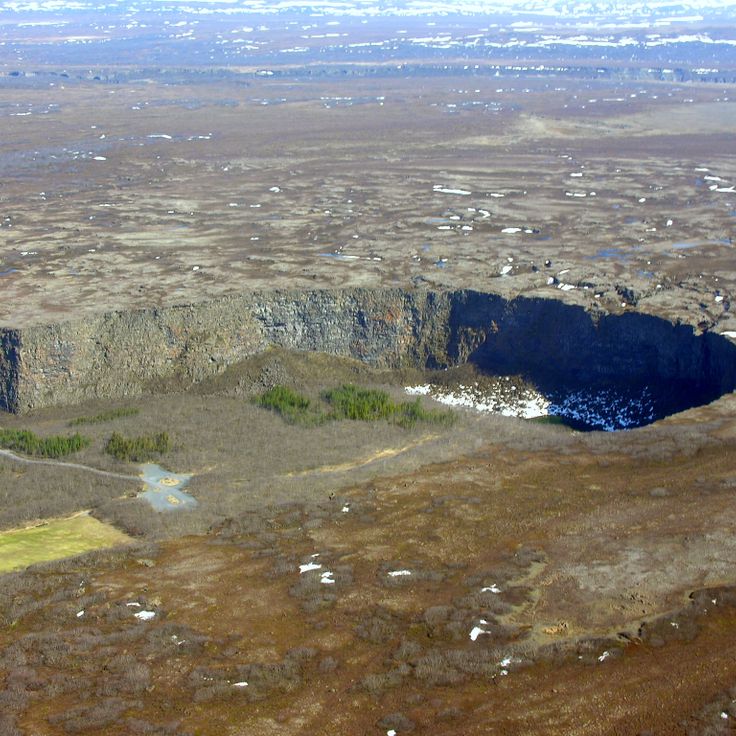
This canyon is a geological formation extending over two miles that was shaped by repeated glacial floods several thousand years ago. The cliff walls rise up to 330 feet high and enclose a forested valley that belongs to Icelandic mythology as the hoofprint of Sleipnir, the eight-legged horse of Odin. The area lies within Vatnajökull National Park and offers hiking trails through birch and willow woodlands, plus access to viewpoints along the cliffs. The horseshoe-shaped structure formed during catastrophic flood events when massive volumes of water from the Vatnajökull glacier carved through the landscape.
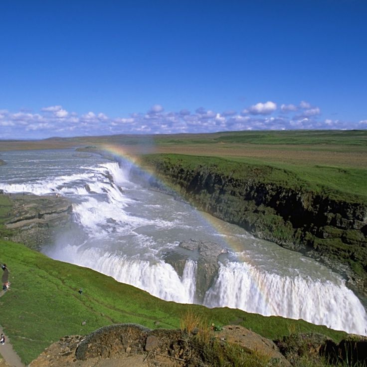
Gullfoss is a natural waterfall that cascades over two successive tiers within a glacial canyon, reaching a total height of 32 feet (32 meters). The waters of the Hvítá River plunge here with considerable force, generating characteristic spray that forms rainbows when light conditions permit. The waterfall sits on the classic Golden Circle route and ranks among Iceland's most visited natural sites. The upper tier drops 36 feet (11 meters), while the lower tier descends an additional 69 feet (21 meters) into the narrow gorge. Visitors can view the falls from several observation platforms that provide different perspectives. Water volume varies significantly depending on the season and glacial meltwater levels.
The Langjökull glacier covers approximately 370 square miles in Iceland's central highlands, making it the country's second largest ice mass. Artificial tunnels carved into the glacier allow visitors to explore its interior structure through illuminated passageways. The route leads through different levels of compressed ice and terminates at a chapel carved entirely from ice. Access is limited to guided tours using specialized vehicles that depart from the glacier's edge. Temperatures inside remain below freezing year round, and the tunnels undergo regular maintenance to ensure visitor safety. The site offers a direct view into the layered composition of glacial ice.
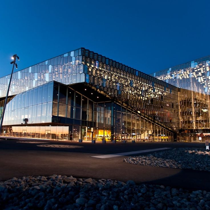
The Harpa stands at Reykjavik's old harbor as a cultural center distinguished by its glass facade designed by Ólafur Elíasson. Geometric colored glass panels reflect changing light and water patterns throughout the day. Opened in 2011, the building houses the Iceland Symphony Orchestra, the Icelandic Opera, and multiple concert halls with professional acoustics. Its architecture references Iceland's basalt formations. Beyond musical performances, the venue hosts conferences and cultural events. Visitors can explore public spaces, use the cafés, and access outdoor terraces with views over the harbor and bay. The building serves as both a working performance space and an architectural landmark in the city.
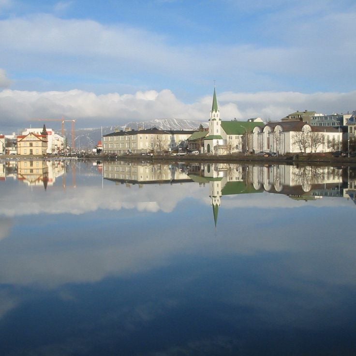
Lake Tjörnin sits in the center of Reykjavik and serves as a local gathering spot for residents and visitors. The body of water lies between the city hall and several government buildings, with waterfowl including ducks, swans and geese present year round. A path circles the lake for roughly 0.9 miles (1.4 kilometers), offering a walk with views of the surrounding architecture and parks. During winter months, the surface often freezes over and becomes a skating area. The lake forms part of the city's green spaces and remains one of the most frequented sites in Iceland's capital, blending urban life with natural surroundings.
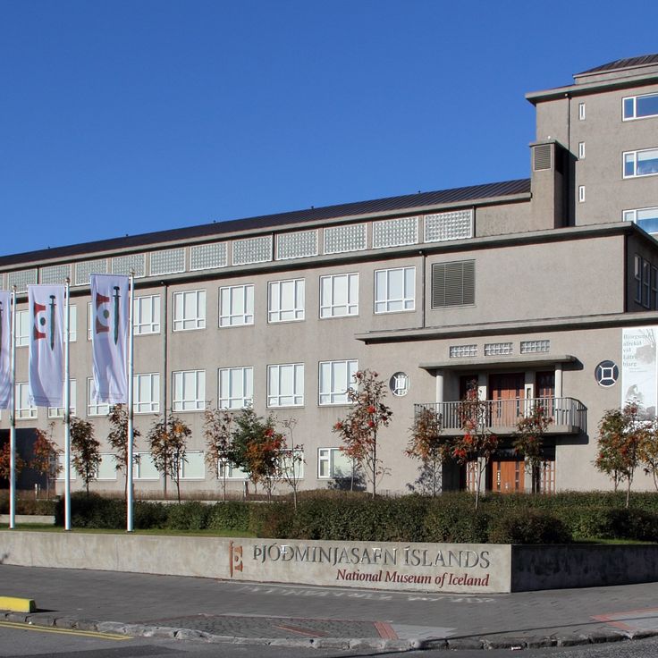
The National Museum traces Iceland's history from the Viking Age to the present through archaeological finds, crafted objects and ethnographic collections. Exhibits include medieval manuscripts, religious artifacts and everyday items that document the evolution of Icelandic society over more than a thousand years. Located near downtown Reykjavik, the museum presents its holdings in chronologically arranged galleries that offer context for the settlement period and subsequent cultural development.
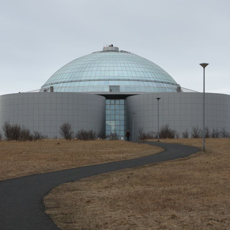
Perlan sits atop Öskjuhlíð hill, combining architectural function with a natural history museum. The glass dome rests on six cylindrical hot water tanks that have formed part of Reykjavík's geothermal infrastructure since 1991. The museum features exhibits on Icelandic natural phenomena, including glaciers, volcanoes and the northern lights. One of the main attractions is a 328-foot (100 meter) artificial ice tunnel that simulates glacier conditions year round. The observation deck beneath the dome offers a 360-degree view of Reykjavík, the surrounding mountains and the Atlantic.
This glacier forms Iceland's third largest ice cap, covering approximately 360 square miles (920 square kilometers) in the central highlands. Hofsjökull sits atop an active volcano whose highest point reaches 5,791 feet (1,765 meters). Beneath the ice surface lies a caldera roughly four miles (six kilometers) in diameter, formed during major eruptions. Several significant glacial rivers originate here, including the Þjórsá, the country's longest river.
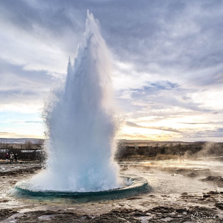
This geyser in the Haukadalur geothermal area shoots a column of water skyward every five to ten minutes, reaching heights up to 100 feet (30 meters). Strokkur and the surrounding hot springs and mud pots form one of the most visited natural sites in Iceland. The eruptions are reliable and allow visitors to witness several in succession. A marked path circles the main pool and provides viewing points from different angles. The site sits on the Golden Circle route, roughly 62 miles (100 kilometers) east of Reykjavik.
The Drangajökull ice cap sits at roughly 915 feet (280 meters) elevation in the northern Westfjords and covers about 62 square miles (160 square kilometers). At its thickest point, the glacier reaches depths of around 650 feet (200 meters). As Iceland's northernmost glacier and the only one in this remote region, it remains relatively stable due to its elevation while other Icelandic glaciers retreat. Access roads are unpaved tracks passable only in summer with appropriate vehicles. Views from the glacier's edge extend across surrounding valleys and fjords.
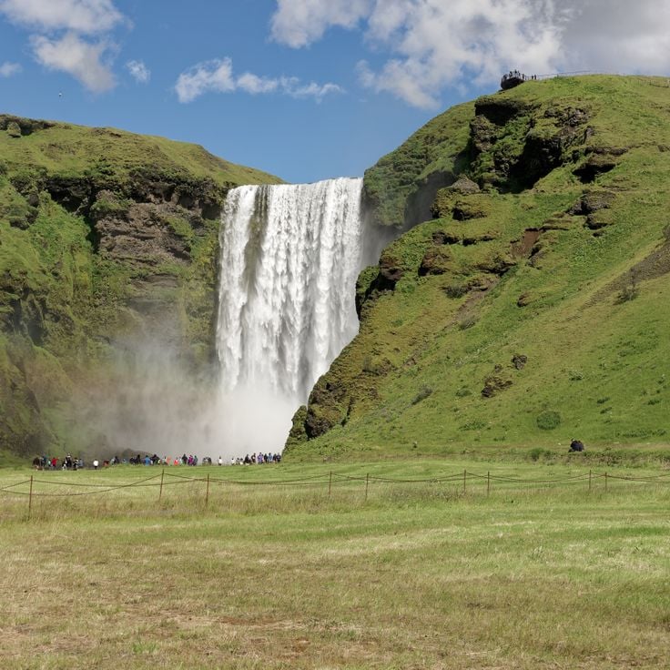
Skogafoss is a 200-foot (60-meter) waterfall on Iceland's south coast, dropping over a 82-foot (25-meter) wide cliff face. The massive flow creates a permanent spray cloud that produces frequent rainbows in sunlight. A staircase with over 500 steps leads to a viewing platform at the top, offering views across the coastal plain and the Atlantic Ocean. The waterfall ranks among Iceland's most visited natural attractions and marks the edge of the former coastline that receded after the last ice age.
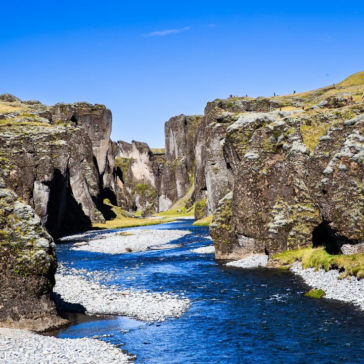
Fjaðrárgljúfúr Canyon stretches for nearly 1.2 miles (2 kilometers) through the volcanic landscape of southern Iceland, guiding visitors along winding paths at the upper edge. The near-vertical rock walls of basalt and palagonite rise up to 330 feet (100 meters), while the Fjaðrá River flows through the narrow gorge at the bottom. Walking trails run along the eastern rim and provide various viewpoints for looking down into the depths. The formation developed about 9,000 years ago through meltwater erosion at the end of the last ice age. Access is from the Ring Road with a short drive on an unpaved road to the parking area.
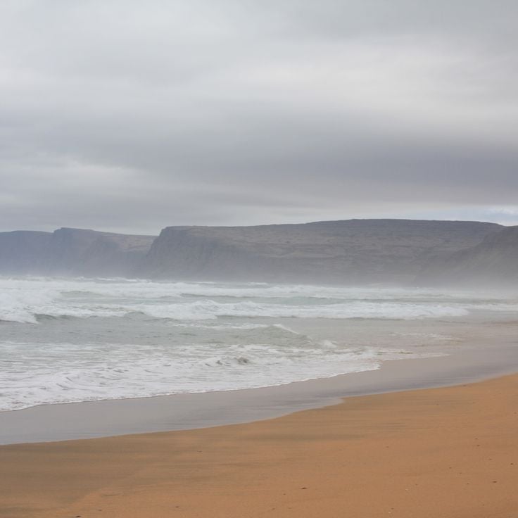
Raudasandur stretches for 6 miles (10 kilometers) along the Westfjords coast and is known for its reddish, orange and golden sands, formed from crushed shells. The shallow waters offshore attract seals that feed in the area. The beach sits in a remote bay accessed by unpaved roads. The intensity of the sand's coloration shifts with changing light conditions and weather patterns.
The Kerlingarfjöll mountains rise to 4846 feet (1477 meters) above sea level and rank among the most geologically active areas in Iceland's interior highlands. These volcanic peaks sit between the Langjökull and Hofsjökull glaciers and host extensive geothermal fields featuring steaming fumaroles, boiling springs and colorful mineral deposits in shades of orange, red and yellow. The range extends across several valleys and plateaus, crisscrossed by hiking trails that provide access to hot springs, solfataras and rhyolite formations. The landscape combines glaciation with volcanic activity, creating an unusual concentration of thermal features within an alpine setting. The site is accessible only during summer months via highland tracks.
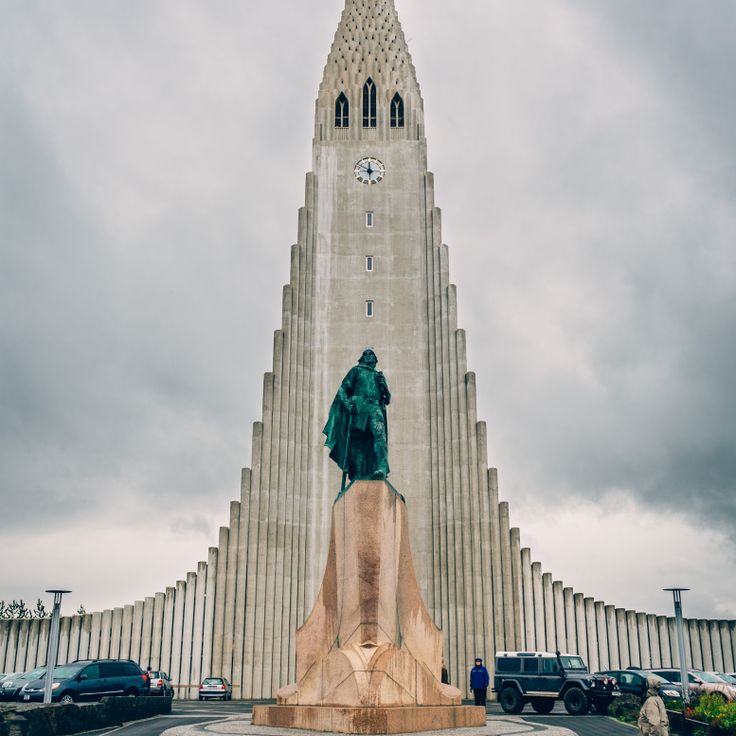
Hallgrímskirkja was built between 1945 and 1986 using concrete and stands out across Reykjavík with its 244-foot (74-meter) tower. The facade references the basalt column formations found along many stretches of Iceland's coastline through its vertical lines. The bell tower offers a panoramic view over the Icelandic capital and the surrounding bay. Inside, a large pipe organ with more than five thousand pipes is used for regular concerts. The church is named after the poet and clergyman Hallgrímur Pétursson, whose passion hymns form part of Iceland's literary tradition. The building serves as a parish church and attracts visitors from around the world who come to view the distinctive structure from within or climb the tower for the city views.
This ring road is Iceland's main transportation artery and traces a complete circuit around the island along the coast for a distance of 830 miles (1,332 kilometers). The Route circulaire connects all major settlements in the country while passing through diverse landscapes ranging from volcanic highlands to eastern fjords. The road remains open year round, though conditions can vary significantly by season. Many travelers use this route for a circuit tour that typically takes between seven and ten days to complete.
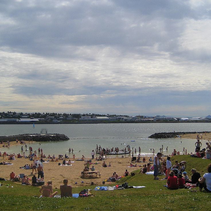
This artificial beach features a temperature-controlled marine lagoon, outdoor hot pools and changing facilities. The water temperature reaches 59 to 66 degrees Fahrenheit (15 to 19 degrees Celsius) in summer. Geothermal water from nearby sources is channeled into the area, making swimming in the North Atlantic more comfortable. The facility includes a sand beach, a separate hot water section and sanitary amenities. Located in a sheltered bay south of central Reykjavík, the beach draws both locals and visitors looking to combine ocean swimming with geothermal warmth.
Viðey Island sits just offshore from Reykjavík and is reached by ferry in a few minutes. Visitors find a mix of art, history and nature here: several large sculptures including Yoko Ono's Imagine Peace Tower, Iceland's oldest stone house dating from 1755, and marked trails that run along the rocky shoreline. The island once served as a religious and administrative center and now hosts a restored building used as a cultural venue. The paths offer views across the surrounding bay and toward the mountains on the mainland.
The Krýsuvík geothermal area sits on the Reykjanes Peninsula and presents an active volcanic zone with hot springs, mud pots and steaming fumaroles that release sulfur vapors. Marked trails lead visitors to various geothermal features, where Iceland's volcanic activity manifests at the surface. The site provides direct access to solfataras and boiling mud fields, their temperatures sustained by underground magma chambers. The area spans several square miles and displays the geothermal processes typical of Iceland in concentrated form.
Skeiðarárjökull extends 19 miles (30 kilometers) from the Vatnajökull ice cap to its 9-mile (15-kilometer) wide terminus. Meltwater flows across an expansive outwash plain carved by multiple glacial rivers that reach the coast. This outlet glacier forms the southernmost tongue of Europe's largest ice field, shaping the terrain through constant movement.
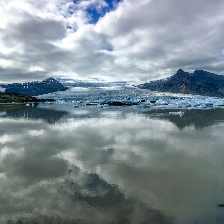
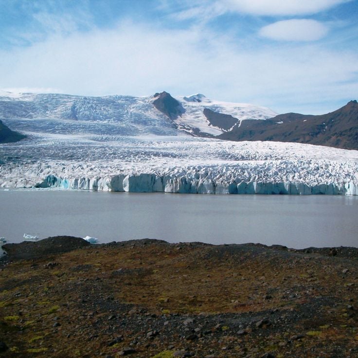
Fjallsárlón sits at the southern edge of Vatnajökull and contains a collection of smaller icebergs that break off from the Fjallsjökull glacier and drift through the calm water. Most visitors reach this glacial lake during a drive along the Ring Road between Höfn and Skaftafell National Park. The water appears in a deep blue under certain light conditions, while gray and white ice masses float on the surface. A short walking trail leads from the parking area to the shore, where the entire glacial basin can be viewed. Fjallsárlón is smaller and receives less attention than its well-known neighbor Jökulsárlón, located about six miles farther east.
Breiðárlón sits in a valley between the more visited Jökulsárlón and Fjallsárlón in southeastern Iceland. The lake formed from meltwater flowing from the Breiðamerkurjökull glacier, an outlet of Vatnajökull. Icebergs drift across its surface, evidence of ongoing glacial retreat. The surrounding terrain is marked by black volcanic sand and gravel, with glacier tongues dominating the horizon. Access is via the Ring Road, though the lake often goes unnoticed compared to its larger neighbors, despite offering similar landscape features.
Lake Veðurárlón sits at the base of Vatnajökull, stretching south of its better-known neighbor Jökulsárlón. Ice blocks drift across the calm water, reflecting the surrounding mountain ranges. The lake forms from meltwater of Europe's largest glacier and offers direct views of the glacier tongue. Visitors encounter far fewer crowds here than at other glacial lakes in the region, while the landscape demonstrates the same geological processes shaping Iceland's south coast.
Svínafellsjökull is an outlet glacier extending from Vatnajökull. The ice walls display alternating white and black colors, as layers of volcanic ash form patterns in the transparent ice. The glacier sits in southern Iceland and ranks among the more accessible parts of Europe's largest ice cap. Visitors come here to observe the contrasts between ice and volcanic deposits left by past eruptions.
The Vatnajökull spans 8,000 square kilometers (3,100 square miles) and forms ice caves during winter. Active volcanoes lie beneath its surface, occasionally erupting and melting the ice from below. The glacier covers several mountains and valleys in southeastern Iceland and feeds numerous glacial rivers flowing toward the coast. Guided tours provide access to the frozen caverns, where blue ice formations shift each year.
This 1990 sculpture by Jón Gunnar Árnason stands along the Reykjavik waterfront and consists of stainless steel columns that form the outline of a Viking ship. The structure reaches a height of approximately 30 feet (9 meters) and has become a popular photo spot for visitors walking along the bay. The work combines modern materials with Nordic maritime tradition and offers open views across the water. Thousands of travelers stop here each year to experience the coastal setting and the clean lines of the installation.
Kirkjufell is a 1,519-foot (463-meter) mountain on the Snæfellsnes Peninsula in western Iceland. Its distinctive cone-shaped profile formed from sedimentary layers of volcanic origin deposited roughly eight million years ago. The mountain sits directly by the sea near the fishing village of Grundarfjörður and is frequently photographed alongside nearby Kirkjufellsfoss waterfall. Hiking trails lead to its summit, though the ascent traverses steep rock slopes and requires secure footing.
Diamond Beach sits along the Atlantic coast where the glacial lagoon Jökulsárlón meets the ocean. Ice chunks of varying sizes wash ashore and scatter across the black volcanic sand. The blocks break off from the nearby Breiðamerkurjökull glacier and drift through the lagoon before reaching the beach. Light conditions shift throughout the day, causing the ice to glow in shades of blue and white against the dark backdrop. Waves continuously reshape and polish the ice formations. The site is accessible year-round from the Ring Road and draws travelers exploring Iceland's southern glacier region.
Reynisfjara stretches along Iceland's southern coast as one of the country's most recognized landscapes. Black volcanic sand covers the shore, while basalt columns form geometric hexagonal patterns along the cliffs. The Reynisdrangar sea stacks rise from the Atlantic, their appearance shifting with changing light. Basalt caves cut into the formations provide natural alcoves, though the surf here can be unpredictable. Waves often reach considerable heights, and several visitors have been caught by sneaker waves over the years. The beach sits roughly 110 miles east of Reykjavik, accessible via the Ring Road.
The Blue Lagoon is a modern geothermal spa located in the Grindavík region, surrounded by black volcanic rock formations. The mineral-rich water is drawn from a depth of approximately 6500 feet (2000 meters) and maintains a constant temperature of 100 degrees Fahrenheit (38 degrees Celsius). Natural minerals including silica and sulfur form the basis for various treatments and skincare products developed on site. The facility includes multiple pools, a restaurant and a spa complex. Bathing takes place outdoors year-round, with experiences varying by season. Located about 12 miles (20 kilometers) from Keflavík International Airport, the Blue Lagoon ranks among Iceland's most visited destinations.
Snæfellsjökull is an ice cap covering a volcano that has been dormant for approximately 1,750 years. This glacier sits at an elevation of 4,744 feet (1,446 meters), features two summits, and extends across roughly 4.2 square miles (11 square kilometers). The formation serves as a prominent landmark on the Snæfellsnes Peninsula and inspired Jules Verne's novel about a journey to the center of the Earth. Glacier walks require proper equipment and a guide. The surrounding region offers numerous hiking trails and geological features that document Iceland's volcanic history.
This volcanic headland rises approximately 400 feet above the Atlantic Ocean on Iceland's southern coast and features a natural rock arch large enough for small boats to pass through. Dyrholaey serves as a nesting ground for puffins and other seabirds during the summer months and offers views from its summit over the region's black sand beaches, the ocean and the surrounding cliffs.
The Hornstrandir Nature Reserve occupies the westernmost fjords of Iceland and has been uninhabited since 1950. Arctic foxes roam this wilderness, while seabirds nest on the cliffs and seals frequent the shores. The landscape consists of rugged mountains, deep fjords and steep rock faces accessible only on foot or by boat. Hiking trails cross the reserve, one of the most remote areas in Europe.
Lake Mývatn is a four-square-mile lake in northern Iceland known for its geological features. The region surrounding the lake contains craters, caves, extensive lava fields and natural hot springs spread across the landscape. The lake itself formed through volcanic activity and sits in an area with numerous pseudocraters and lava formations. The Mývatn area ranks among Iceland's most geologically active zones and displays various volcanic phenomena that visitors can explore via marked trails.
This canyon is a geological formation extending over two miles that was shaped by repeated glacial floods several thousand years ago. The cliff walls rise up to 330 feet high and enclose a forested valley that belongs to Icelandic mythology as the hoofprint of Sleipnir, the eight-legged horse of Odin. The area lies within Vatnajökull National Park and offers hiking trails through birch and willow woodlands, plus access to viewpoints along the cliffs. The horseshoe-shaped structure formed during catastrophic flood events when massive volumes of water from the Vatnajökull glacier carved through the landscape.
Gullfoss is a natural waterfall that cascades over two successive tiers within a glacial canyon, reaching a total height of 32 feet (32 meters). The waters of the Hvítá River plunge here with considerable force, generating characteristic spray that forms rainbows when light conditions permit. The waterfall sits on the classic Golden Circle route and ranks among Iceland's most visited natural sites. The upper tier drops 36 feet (11 meters), while the lower tier descends an additional 69 feet (21 meters) into the narrow gorge. Visitors can view the falls from several observation platforms that provide different perspectives. Water volume varies significantly depending on the season and glacial meltwater levels.
The Langjökull glacier covers approximately 370 square miles in Iceland's central highlands, making it the country's second largest ice mass. Artificial tunnels carved into the glacier allow visitors to explore its interior structure through illuminated passageways. The route leads through different levels of compressed ice and terminates at a chapel carved entirely from ice. Access is limited to guided tours using specialized vehicles that depart from the glacier's edge. Temperatures inside remain below freezing year round, and the tunnels undergo regular maintenance to ensure visitor safety. The site offers a direct view into the layered composition of glacial ice.
The Harpa stands at Reykjavik's old harbor as a cultural center distinguished by its glass facade designed by Ólafur Elíasson. Geometric colored glass panels reflect changing light and water patterns throughout the day. Opened in 2011, the building houses the Iceland Symphony Orchestra, the Icelandic Opera, and multiple concert halls with professional acoustics. Its architecture references Iceland's basalt formations. Beyond musical performances, the venue hosts conferences and cultural events. Visitors can explore public spaces, use the cafés, and access outdoor terraces with views over the harbor and bay. The building serves as both a working performance space and an architectural landmark in the city.
Lake Tjörnin sits in the center of Reykjavik and serves as a local gathering spot for residents and visitors. The body of water lies between the city hall and several government buildings, with waterfowl including ducks, swans and geese present year round. A path circles the lake for roughly 0.9 miles (1.4 kilometers), offering a walk with views of the surrounding architecture and parks. During winter months, the surface often freezes over and becomes a skating area. The lake forms part of the city's green spaces and remains one of the most frequented sites in Iceland's capital, blending urban life with natural surroundings.
The National Museum traces Iceland's history from the Viking Age to the present through archaeological finds, crafted objects and ethnographic collections. Exhibits include medieval manuscripts, religious artifacts and everyday items that document the evolution of Icelandic society over more than a thousand years. Located near downtown Reykjavik, the museum presents its holdings in chronologically arranged galleries that offer context for the settlement period and subsequent cultural development.
Perlan sits atop Öskjuhlíð hill, combining architectural function with a natural history museum. The glass dome rests on six cylindrical hot water tanks that have formed part of Reykjavík's geothermal infrastructure since 1991. The museum features exhibits on Icelandic natural phenomena, including glaciers, volcanoes and the northern lights. One of the main attractions is a 328-foot (100 meter) artificial ice tunnel that simulates glacier conditions year round. The observation deck beneath the dome offers a 360-degree view of Reykjavík, the surrounding mountains and the Atlantic.
This glacier forms Iceland's third largest ice cap, covering approximately 360 square miles (920 square kilometers) in the central highlands. Hofsjökull sits atop an active volcano whose highest point reaches 5,791 feet (1,765 meters). Beneath the ice surface lies a caldera roughly four miles (six kilometers) in diameter, formed during major eruptions. Several significant glacial rivers originate here, including the Þjórsá, the country's longest river.
This geyser in the Haukadalur geothermal area shoots a column of water skyward every five to ten minutes, reaching heights up to 100 feet (30 meters). Strokkur and the surrounding hot springs and mud pots form one of the most visited natural sites in Iceland. The eruptions are reliable and allow visitors to witness several in succession. A marked path circles the main pool and provides viewing points from different angles. The site sits on the Golden Circle route, roughly 62 miles (100 kilometers) east of Reykjavik.
The Drangajökull ice cap sits at roughly 915 feet (280 meters) elevation in the northern Westfjords and covers about 62 square miles (160 square kilometers). At its thickest point, the glacier reaches depths of around 650 feet (200 meters). As Iceland's northernmost glacier and the only one in this remote region, it remains relatively stable due to its elevation while other Icelandic glaciers retreat. Access roads are unpaved tracks passable only in summer with appropriate vehicles. Views from the glacier's edge extend across surrounding valleys and fjords.
Skogafoss is a 200-foot (60-meter) waterfall on Iceland's south coast, dropping over a 82-foot (25-meter) wide cliff face. The massive flow creates a permanent spray cloud that produces frequent rainbows in sunlight. A staircase with over 500 steps leads to a viewing platform at the top, offering views across the coastal plain and the Atlantic Ocean. The waterfall ranks among Iceland's most visited natural attractions and marks the edge of the former coastline that receded after the last ice age.
Fjaðrárgljúfúr Canyon stretches for nearly 1.2 miles (2 kilometers) through the volcanic landscape of southern Iceland, guiding visitors along winding paths at the upper edge. The near-vertical rock walls of basalt and palagonite rise up to 330 feet (100 meters), while the Fjaðrá River flows through the narrow gorge at the bottom. Walking trails run along the eastern rim and provide various viewpoints for looking down into the depths. The formation developed about 9,000 years ago through meltwater erosion at the end of the last ice age. Access is from the Ring Road with a short drive on an unpaved road to the parking area.
Raudasandur stretches for 6 miles (10 kilometers) along the Westfjords coast and is known for its reddish, orange and golden sands, formed from crushed shells. The shallow waters offshore attract seals that feed in the area. The beach sits in a remote bay accessed by unpaved roads. The intensity of the sand's coloration shifts with changing light conditions and weather patterns.
The Kerlingarfjöll mountains rise to 4846 feet (1477 meters) above sea level and rank among the most geologically active areas in Iceland's interior highlands. These volcanic peaks sit between the Langjökull and Hofsjökull glaciers and host extensive geothermal fields featuring steaming fumaroles, boiling springs and colorful mineral deposits in shades of orange, red and yellow. The range extends across several valleys and plateaus, crisscrossed by hiking trails that provide access to hot springs, solfataras and rhyolite formations. The landscape combines glaciation with volcanic activity, creating an unusual concentration of thermal features within an alpine setting. The site is accessible only during summer months via highland tracks.
Hallgrímskirkja was built between 1945 and 1986 using concrete and stands out across Reykjavík with its 244-foot (74-meter) tower. The facade references the basalt column formations found along many stretches of Iceland's coastline through its vertical lines. The bell tower offers a panoramic view over the Icelandic capital and the surrounding bay. Inside, a large pipe organ with more than five thousand pipes is used for regular concerts. The church is named after the poet and clergyman Hallgrímur Pétursson, whose passion hymns form part of Iceland's literary tradition. The building serves as a parish church and attracts visitors from around the world who come to view the distinctive structure from within or climb the tower for the city views.
This ring road is Iceland's main transportation artery and traces a complete circuit around the island along the coast for a distance of 830 miles (1,332 kilometers). The Route circulaire connects all major settlements in the country while passing through diverse landscapes ranging from volcanic highlands to eastern fjords. The road remains open year round, though conditions can vary significantly by season. Many travelers use this route for a circuit tour that typically takes between seven and ten days to complete.
This artificial beach features a temperature-controlled marine lagoon, outdoor hot pools and changing facilities. The water temperature reaches 59 to 66 degrees Fahrenheit (15 to 19 degrees Celsius) in summer. Geothermal water from nearby sources is channeled into the area, making swimming in the North Atlantic more comfortable. The facility includes a sand beach, a separate hot water section and sanitary amenities. Located in a sheltered bay south of central Reykjavík, the beach draws both locals and visitors looking to combine ocean swimming with geothermal warmth.
Viðey Island sits just offshore from Reykjavík and is reached by ferry in a few minutes. Visitors find a mix of art, history and nature here: several large sculptures including Yoko Ono's Imagine Peace Tower, Iceland's oldest stone house dating from 1755, and marked trails that run along the rocky shoreline. The island once served as a religious and administrative center and now hosts a restored building used as a cultural venue. The paths offer views across the surrounding bay and toward the mountains on the mainland.
The Krýsuvík geothermal area sits on the Reykjanes Peninsula and presents an active volcanic zone with hot springs, mud pots and steaming fumaroles that release sulfur vapors. Marked trails lead visitors to various geothermal features, where Iceland's volcanic activity manifests at the surface. The site provides direct access to solfataras and boiling mud fields, their temperatures sustained by underground magma chambers. The area spans several square miles and displays the geothermal processes typical of Iceland in concentrated form.
Skeiðarárjökull extends 19 miles (30 kilometers) from the Vatnajökull ice cap to its 9-mile (15-kilometer) wide terminus. Meltwater flows across an expansive outwash plain carved by multiple glacial rivers that reach the coast. This outlet glacier forms the southernmost tongue of Europe's largest ice field, shaping the terrain through constant movement.
Fjallsárlón sits at the southern edge of Vatnajökull and contains a collection of smaller icebergs that break off from the Fjallsjökull glacier and drift through the calm water. Most visitors reach this glacial lake during a drive along the Ring Road between Höfn and Skaftafell National Park. The water appears in a deep blue under certain light conditions, while gray and white ice masses float on the surface. A short walking trail leads from the parking area to the shore, where the entire glacial basin can be viewed. Fjallsárlón is smaller and receives less attention than its well-known neighbor Jökulsárlón, located about six miles farther east.
Breiðárlón sits in a valley between the more visited Jökulsárlón and Fjallsárlón in southeastern Iceland. The lake formed from meltwater flowing from the Breiðamerkurjökull glacier, an outlet of Vatnajökull. Icebergs drift across its surface, evidence of ongoing glacial retreat. The surrounding terrain is marked by black volcanic sand and gravel, with glacier tongues dominating the horizon. Access is via the Ring Road, though the lake often goes unnoticed compared to its larger neighbors, despite offering similar landscape features.
Lake Veðurárlón sits at the base of Vatnajökull, stretching south of its better-known neighbor Jökulsárlón. Ice blocks drift across the calm water, reflecting the surrounding mountain ranges. The lake forms from meltwater of Europe's largest glacier and offers direct views of the glacier tongue. Visitors encounter far fewer crowds here than at other glacial lakes in the region, while the landscape demonstrates the same geological processes shaping Iceland's south coast.
Svínafellsjökull is an outlet glacier extending from Vatnajökull. The ice walls display alternating white and black colors, as layers of volcanic ash form patterns in the transparent ice. The glacier sits in southern Iceland and ranks among the more accessible parts of Europe's largest ice cap. Visitors come here to observe the contrasts between ice and volcanic deposits left by past eruptions.