Villages hanging above the sea, dry-stone Cistercian abbeys, and rocks shaped by millions of years: this is the face of Provence.
The Provence-Alpes-Côte d'Azur region combines medieval villages, historical fortifications, and natural areas between the Mediterranean coast and the Alps. The landscape ranges from the lavender-covered plateaus of Valensole to the steep limestone cliffs of the Calanques and alpine passes above 8,900 feet (2,700 meters). Geological formations like the mushroom-shaped Demoiselles Coiffées de Théus and the reddish sandstone rocks of Annot show millions of years of natural shaping. Monasteries such as Abbaye de Sénanque and Thoronet Abbey preserve Cistercian architecture, while villages like Gordes and Les Baux-de-Provence maintain their medieval layouts.
The coastal settlements of Èze, Menton, and Gourdon sit on rocky perches above the Côte d'Azur, their narrow streets leading to viewpoints overlooking the sea. The Lérins Islands off Cannes and the Îles d'Hyères offer quieter coastal landscapes with Mediterranean vegetation. Inland, hiking trails like Sentier Martel pass through the Verdon Gorge, while the Vallée des Merveilles displays prehistoric rock engravings in an alpine setting. Fortifications including the Citadelle de Sisteron, Fort Carré in Antibes, and the ruins of Fort de Buoux document centuries of military history at strategic passages and heights.
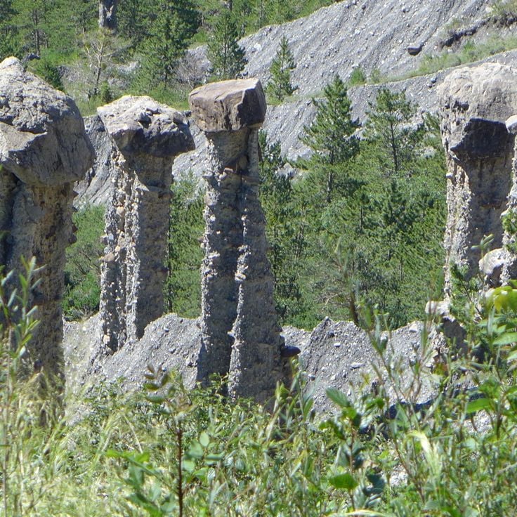
These geological formations consist of columns crowned by boulders, as if giants had stacked stones on top of each other. Erosion and time shaped the landscape: water and wind wore away soft rock, while harder blocks protected the columns from further decay. The area feels like another world, with towers of clay and rubble rising among forests and meadows. Walking trails lead between the columns, so you can see them up close. The scene changes with the light: in the morning the sun casts long shadows, while at sunset it turns the rocks orange. The site lies away from main roads, and few visitors come here, so you often walk alone among the formations.
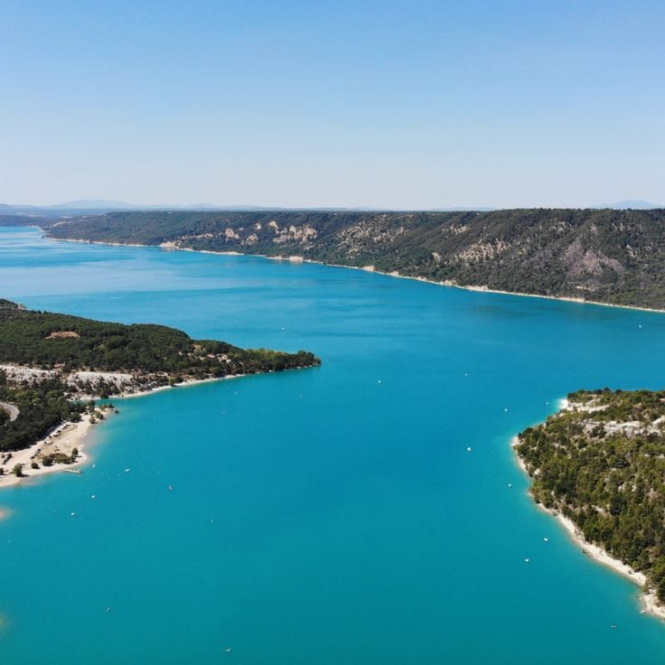
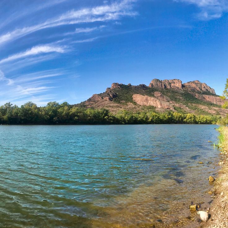
This artificial lake formed in 1973 when a dam was built on the Verdon River at the southwestern end of the Verdon Gorge. The turquoise water stretches for several miles between forested slopes and limestone cliffs. From the shoreline you can see small coves with pebble beaches and pedal boats moving across the calm surface. Hiking trails run along the water's edge, where people gather in summer to swim and picnic. The surrounding villages such as Sainte-Croix-du-Verdon and Les Salles-sur-Verdon serve as starting points for kayak trips through the Verdon. The landscape combines the Mediterranean vegetation of inland Provence with the rugged geology of the Alpine foothills.
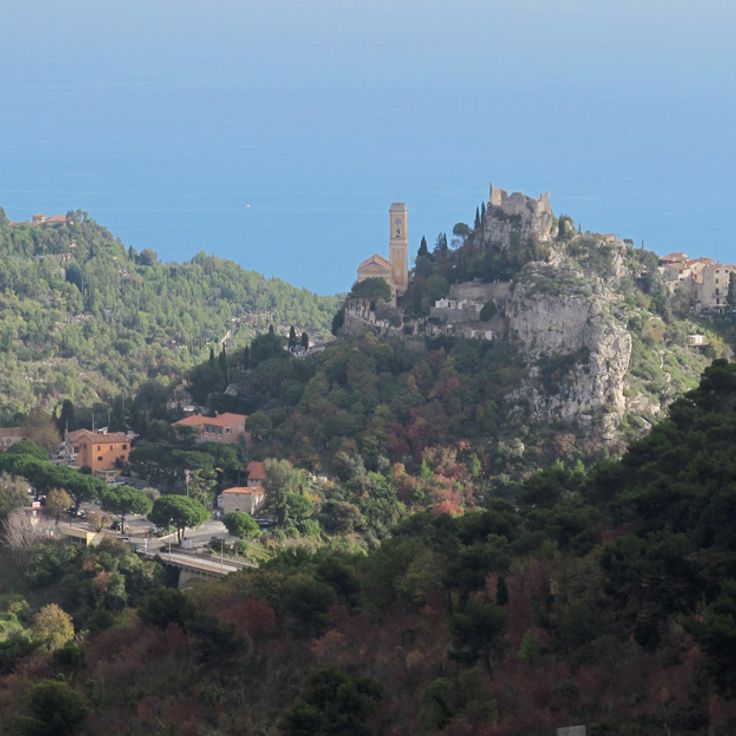
This medieval village clings to a rocky outcrop high above the Mediterranean. Eze Village preserves its original appearance with narrow stone alleys, old houses, and staircases winding between the walls. Once you reach the top, the view opens wide across the coastline, the deep blue water, and the surrounding mountains. The streets are quiet, shaded, and lined with plants. Craftspeople and small shops occupy the old buildings. The village is one of the traditional settlements in the region that has kept its medieval structure.
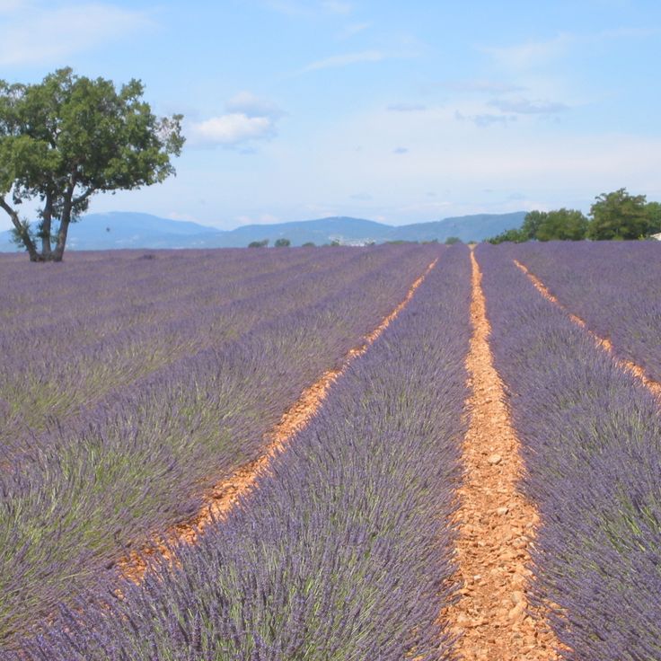
The Plateau de Valensole is a flat highland area known for its lavender fields, which spread across several communes. The purple blooms appear in summer and attract visitors who come to experience the Provençal countryside. Between the fields are farms and small villages where growers cultivate lavender for perfume and essential oils. The plateau sits between the Durance valley and the hills of Haute-Provence, offering wide views over the region.
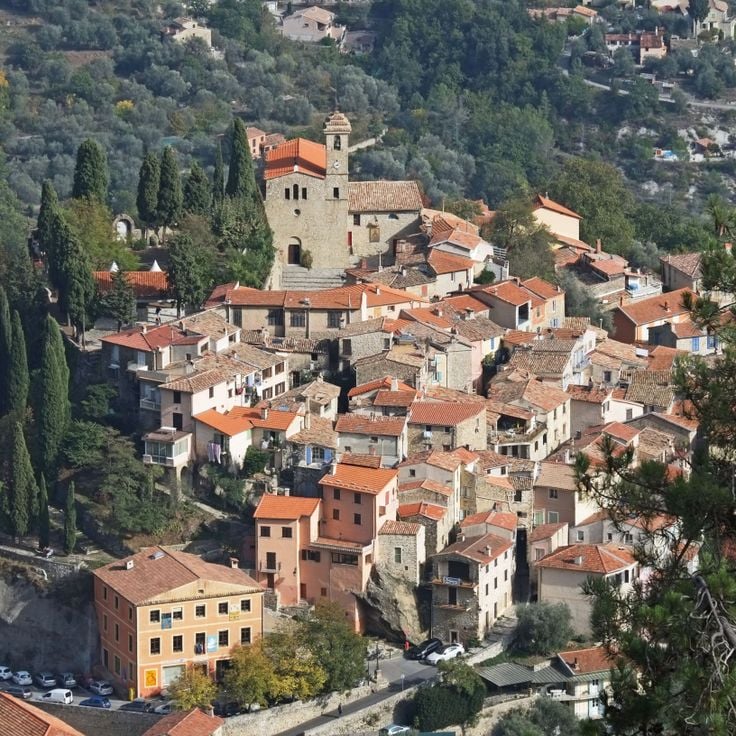
This mountain village ranks among the most beautiful in France. Hand-painted sundials decorate its facades, some created by well-known artists. Narrow alleys wind between old stone houses. From higher points you can look over the surrounding valleys. The village keeps its medieval layout and shows elements of regional architecture from different centuries.
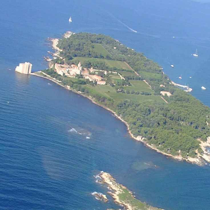
This island holds a monastery from the 5th century and draws people looking for silence away from the coastal crowds. Monks have tended vineyards here for centuries and continue to make wine today. Olive trees and Mediterranean plants grow between the monastery walls, shaping the view. Visitors can explore the old chapel, the fortified tower by the water, and the monastery complex. From the paths, you see the sea and the coast of Cannes. Wine production connects the monastic tradition with the Provence landscape, and life on the island follows a quiet rhythm. This historical heritage shows how monks in the region lived and worked through the centuries.
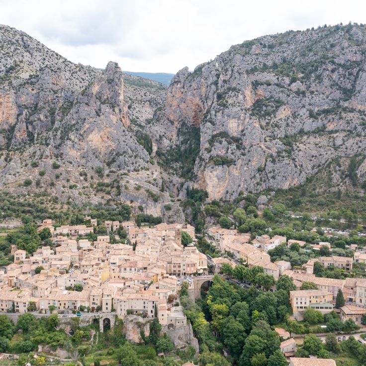
This village sits between two rock cliffs in the Verdon region and has been known for its faience pottery production since the 17th century. The narrow lanes lead to small workshops where artisans continue to use traditional techniques. A golden chain with a star hangs from the cliffs, attributed to a local legend. The village layout preserves the character of medieval settlements in this region, with stone houses and covered passageways. A small chapel stands on a rocky outcrop above the village, offering wide views over the surrounding countryside.
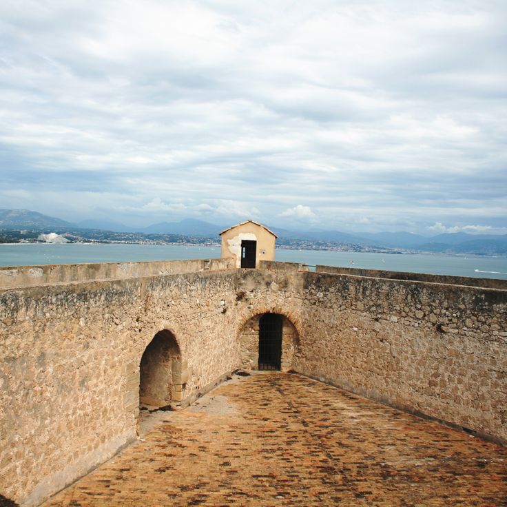
This fortress, built in the 16th century to protect the French border, stands on the coast between Nice and Cannes. Fort Carré shows Renaissance military architecture with four star-shaped bastions made of gray stone. The walls rise above the sea and offer views over the bay and the surrounding hills. Narrow passages and casemates lead through the interior of the structure. The fortress belongs to the historical buildings in Provence that served for centuries to defend the territory.
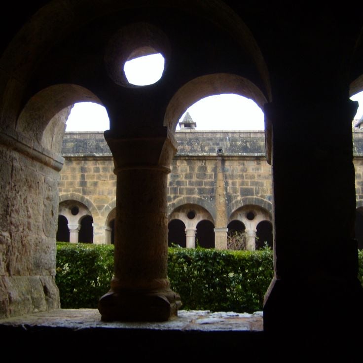
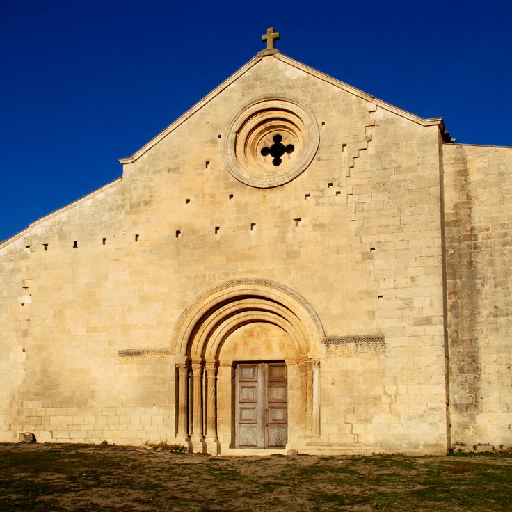
This abbey dates from the 12th century and follows the Romanesque architecture of the Cistercian order. The church has particular acoustic properties created by its construction methods and materials. Smooth stone walls and minimal decoration define the interior. The monastery sits in a wooded valley and displays the austere Cistercian style through its cloister, chapter house, and monks' dormitory. The site conveys a sense of calm and offers insight into medieval monastic life in Provence.
The old town of Menton climbs a hillside near the Italian border. Cobbled lanes pass through clusters of houses painted in ochre and pastel shades. Upper streets open onto small squares with views of the Mediterranean. Staircases connect different levels and descend toward the old harbor. Laundry lines hang between facades. The architecture shows Ligurian influences with narrow passageways and arcades. Orange trees grow in pots at doorways. The Parvis Saint-Michel is a broad terrace paved with white and gray pebbles.
These islands lie off the coast of Cannes, formed by two main landmasses that each have their own history and rhythm. On the larger island stands a monastery from the 11th century, home to monks who work and pray in silence. The smaller island is covered with pine forests that reach down to the sea. Small coves appear between the rocks where people swim. From the mainland, the Lérins Islands are reachable by boat in a few minutes.
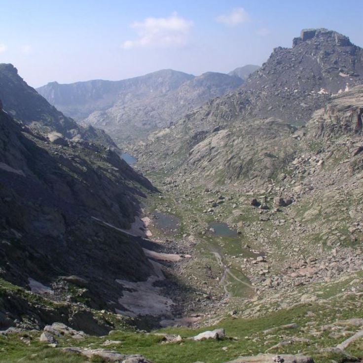
This mountain valley holds more than 40,000 rock carvings from the Bronze Age, spread across rock faces and smooth stone surfaces. Hiking trails wind through the area, passing mountain lakes and alpine meadows at different elevations. The carvings show geometric shapes, animal figures, and human forms that were made several thousand years ago. The terrain rises gradually, surrounded by peaks and rocky slopes. In summer, wildflowers grow between the stones, while winter brings snow to the higher sections. The air is thin and clear, typical of this altitude. Visitors follow marked paths that lead to the main sites where the engravings remain visible. The landscape combines history with nature, in a setting that has stayed largely unchanged since ancient times.
Bargème sits at 1,097 meters (3,600 feet) above sea level and ranks among the highest villages in the region. This medieval village shows stone houses, narrow lanes, and remains of a 13th-century castle that once controlled the surrounding area. From here, you see the Alps to the north and the Provençal hills to the south. The location attracted people in the Middle Ages who sought protection and a strategic position. Today, only a few residents live here year-round, and visitors come for the quiet feel and the long views. The architecture reflects building methods from earlier centuries, when defense and climate shaped design.
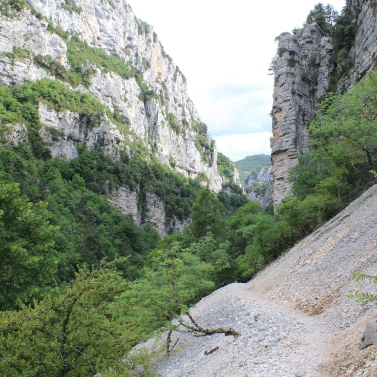
This trail crosses the Verdon Canyon over 9 miles (14 kilometers) and offers viewpoints from which the river flows 2,300 feet (700 meters) below. The Sentier Martel belongs to the historical sites and natural landscapes of Provence and passes through one of the deepest canyons in Europe, with steep rock walls and turquoise water.
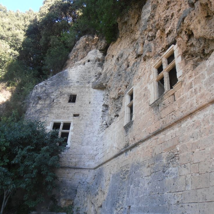
These caves lie in a park with gardens at the edge of a village in Var. Water falls 65 feet (20 meters) over tufa stone that formed over centuries. The caves were inhabited in the 12th century and later converted into living spaces. You reach them by stairs cut into the rock. Openings in the rock face let daylight in. The park around the caves is planted with trees and plants that benefit from the water. The site shows how people used and adapted natural rock cavities.
This red rock formation rises above the Var landscape, reaching 373 meters above sea level. The steep walls provide climbing routes of varying difficulty for experienced and novice climbers alike. From the top, you see the hills of Provence, forested valleys, and the Mediterranean Sea in the distance. The rock shapes the surroundings of Roquebrune-sur-Argens and belongs to the geological features of the Provence-Alpes-Côte d'Azur region. Walking trails pass through Mediterranean vegetation at the base of the massif, where pine trees and holm oaks grow. On clear days, the view extends to the mountain ranges of the Maritime Alps.
This rock formation extends across acres of sandstone blocks set in a pine forest, with marked hiking and climbing paths. The Annot Sandstone formed millions of years ago through deposits and now shows massive boulders rising among the trees. Visitors can walk the trails through the forest and observe the reddish formations piled at different heights. The area preserves this natural feature of Provence and invites hikers and climbers to explore. The forest surrounds the stones and creates a shaded setting for walks between the geological structures.
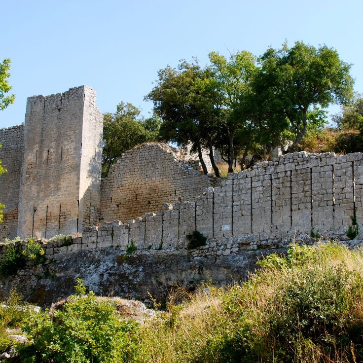
This medieval fortress sits on a limestone cliff in Luberon Natural Park. The walls and passages stretch across several levels and tell of centuries of military use. Visitors can climb through staircases and corridors carved into the rock, past remains of living quarters, cisterns, and defensive structures. The position on the rocky outcrop offered strategic protection over the valley. From the upper areas, views open across the forested hills and villages of Provence. The site connects history with the Luberon landscape and shows how people shaped this rock formation over centuries.
This waterfall drops 42 meters (138 feet) into a natural basin and stands as one of the most recognizable natural features in the Var area. Water falls over a moss-covered rock face and gathers in an emerald-green pool at the base of the cascade. Marked trails lead through the surrounding forest to viewpoints where visitors can watch the waterfall. The area around Sillans-la-Cascade stays cool and damp even on hot summer days, and the forest smells of wet stone and vegetation.
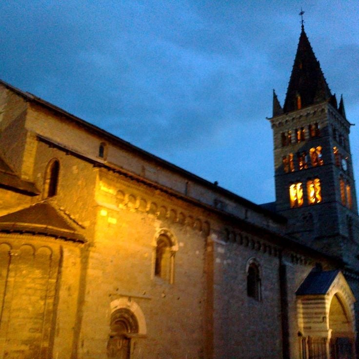
This 12th-century church combines Romanesque and Gothic forms in a mountain town in the Hautes-Alpes. The bell tower rises 35 meters (115 feet) and shapes the town's skyline. Stonework on the portal and facade shows the craftsmanship of the region. Inside are vaulted spaces and chapels that speak to the religious history of Provence.
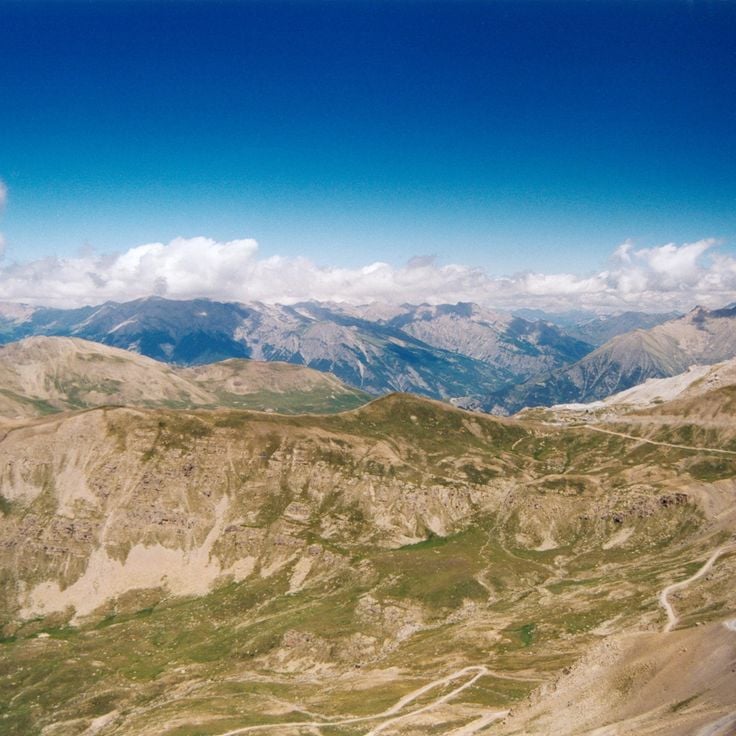
This mountain pass sits at 2715 meters (8907 feet) in the Alpes-Maritimes. The road runs through Mercantour National Park and offers wide views of the surrounding Alpine peaks. The landscape shifts between rock, meadows and snow-covered slopes, depending on the season. In summer the route opens for cyclists and hikers who come for the clear mountain air and the quiet of the high elevations. The pass connects two valleys and shows the raw face of the southern Alps, where nature and altitude set the rhythm.
This archipelago in the Mediterranean consists of three main islands off the coast of Provence. Porquerolles shows sandy coves and pine forests, Port-Cros protects Mediterranean plants and animals as a national park, while Île du Levant hosts a naturist village. The islands preserve natural landscapes with rocky coastlines, fragrant maquis shrubland, and clear waters. Visitors reach them by ferry from the mainland and find walking trails through forests and along cliffs.
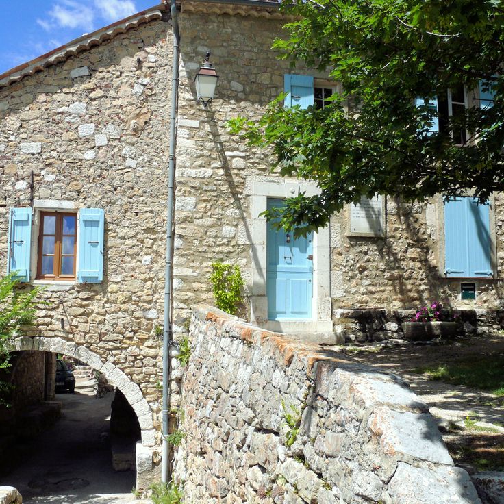
This village stands on a rock in the Luberon and belongs to the historical sites of Provence. The houses are built from regional stone and connected by narrow streets. The architecture follows the medieval tradition of the region, with buildings that cling to the hillside. From here you can see the surrounding lavender fields and the mountains of Provence. The village preserves its historical appearance and shows the traditional construction methods of the region.
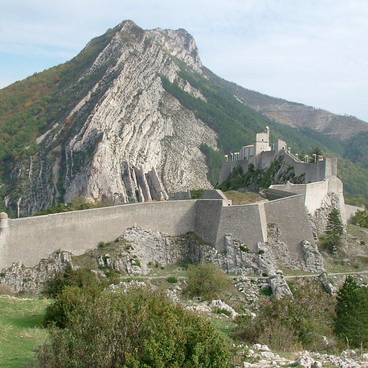
This fortress from the 13th century sits on a rocky outcrop above the Durance valley. The citadel of Sisteron combines military structures from different periods with botanical gardens displaying Mediterranean plants. Walls and towers follow the natural shape of the rock and offer views across the surrounding area. Inside you find casemates, chapels, and a museum that presents the history of the fortress. The site shows how military architecture worked with terrain, and adds to the landscape of Provence, where historical fortresses and castle ruins mark the region.
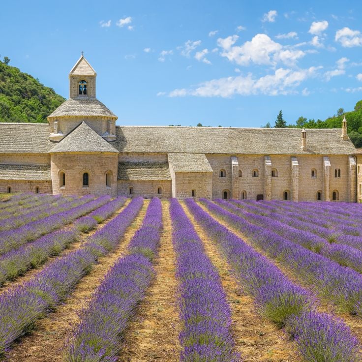
This twelfth-century Cistercian abbey houses twelve monks who follow the strict rules of their order. The stone buildings sit in a remote valley, where lavender fields turn the surroundings into a purple expanse during summer. The church displays Romanesque architecture with simple lines and little decoration, as the Cistercian tradition requires.
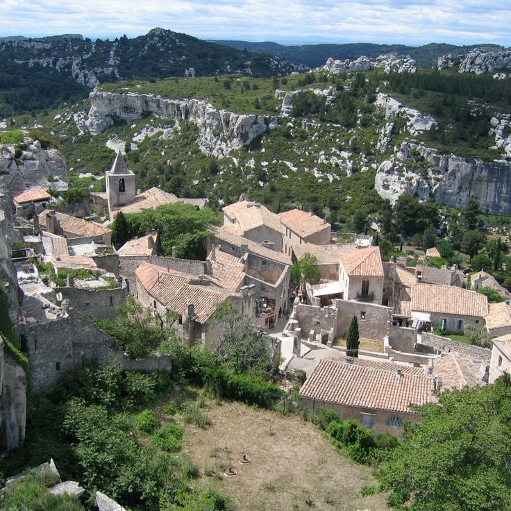
This village stands on a 820-foot (245-meter) limestone plateau in the Alpilles. The lanes of Les Baux-de-Provence wind between old stone houses that cling to the rock. The castle ruins open onto the valley and the mountains. In some places, the buildings merge with the stone itself. Craft shops and small museums fill the old houses. Wind sweeps across the plateau, carrying the scent of wild herbs from below. From the highest point, you look over the plain toward the mountains.
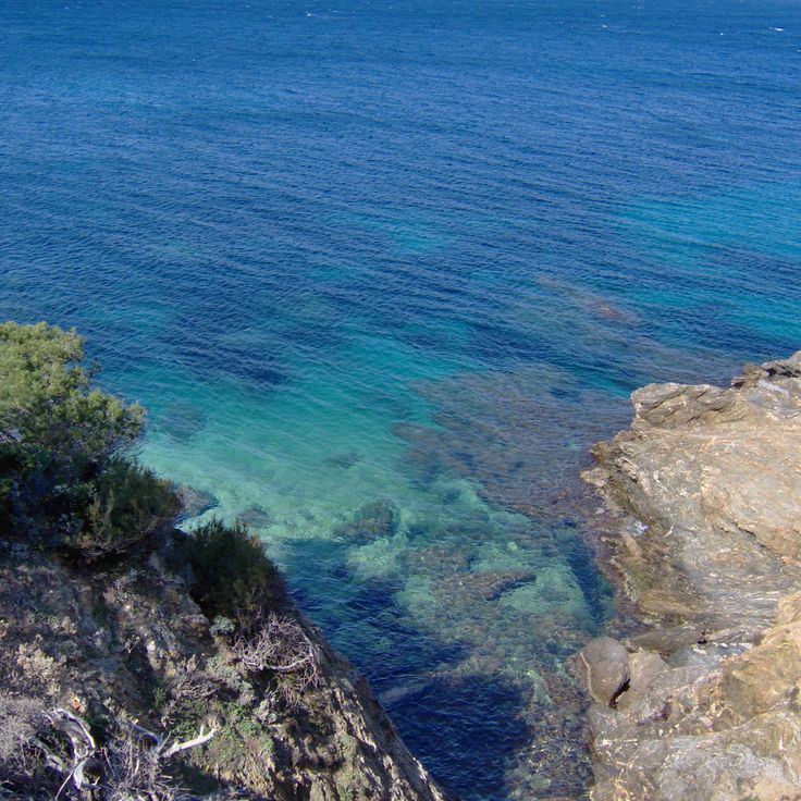
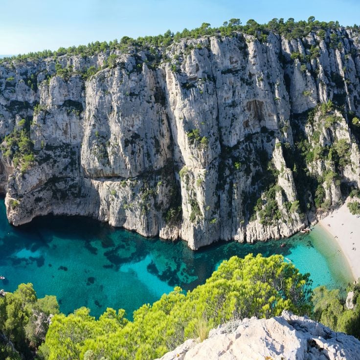
This calanque sits between two steep limestone walls that rise about 150 meters (490 feet) from the water. The narrow inlet opens toward the sea, and the water shifts between turquoise and deep blue tones. The beach is made of white pebbles that feel warm underfoot. The rock faces are shaped by wind and salt water, with cracks and crevices that cast shadows depending on the time of day. The water is clear enough to see the bottom, and it stays cool even in summer. Fishermen sometimes arrive in small boats, and swimmers use the sheltered position. This calanque is part of a longer coastline made up of several such inlets.
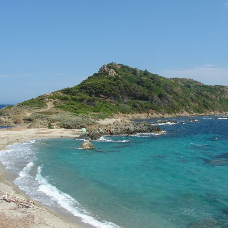
This narrow strip of land reaches out between two sandy beaches and forms a natural section of the Provençal coastline. The coastal path crosses low vegetation with holm oaks and Mediterranean plants that cling to the rocks. The water is shallow and clear, and the beaches remain free from development. At sunrise, light casts long shadows across the sand and stones. In summer, hikers arrive early in the morning to avoid the heat. Cap Taillat preserves the raw beauty of the coastal landscape in southern France.
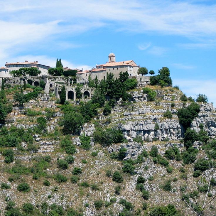
This village sits at 760 meters above sea level on a limestone rock and is one of the places in Provence where history and natural surroundings meet. Gourdon offers views over the Loup Valley to the Mediterranean Sea and shows medieval architecture with stone houses, narrow streets and an old castle. The position between the French Alps and the coast makes it an example of the settlements built on rock outcrops. Craft shops and local products reflect the traditions of the region.
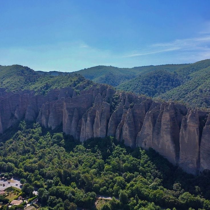
The Pénitents des Mées are a line of vertical rocks that extend for about two kilometers along a hillside. These puddingstone formations were shaped by erosion over thousands of years. Their narrow, upright shapes resemble a procession of monks in robes, which gave the place its name. The rocks rise between 330 and 375 feet (100 and 114 meters) above the valley and form a distinct silhouette in the Provençal landscape. Trails wind between the rock spires and offer views over the Durance valley and surrounding lavender fields.
This priory in the Alpes-de-Haute-Provence brings together Romanesque monastic architecture from the 12th century with five thematic gardens. The grounds display plants from different regions and historical periods, documenting the agricultural and botanical heritage of Provence. The Prieuré de Salagon serves as an example of medieval monastery complexes in the region, where religious life intertwined with the cultivation of medicinal and useful plants.
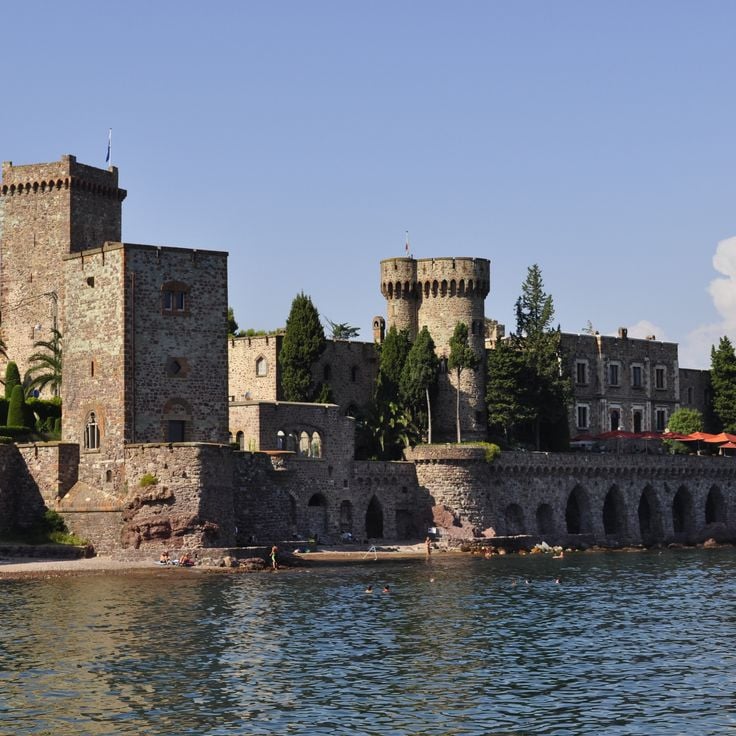
This seaside fortress dates back to the 14th century and was later transformed by Henry Clews. Château de la Napoule combines medieval towers and walls with a sculpture garden and Roman columns. The castle sits directly on the coast, overlooking the Mediterranean. Visitors find here Clews' artworks, inner courtyards, and terraces that open toward the water.
These geological formations consist of columns crowned by boulders, as if giants had stacked stones on top of each other. Erosion and time shaped the landscape: water and wind wore away soft rock, while harder blocks protected the columns from further decay. The area feels like another world, with towers of clay and rubble rising among forests and meadows. Walking trails lead between the columns, so you can see them up close. The scene changes with the light: in the morning the sun casts long shadows, while at sunset it turns the rocks orange. The site lies away from main roads, and few visitors come here, so you often walk alone among the formations.
This artificial lake formed in 1973 when a dam was built on the Verdon River at the southwestern end of the Verdon Gorge. The turquoise water stretches for several miles between forested slopes and limestone cliffs. From the shoreline you can see small coves with pebble beaches and pedal boats moving across the calm surface. Hiking trails run along the water's edge, where people gather in summer to swim and picnic. The surrounding villages such as Sainte-Croix-du-Verdon and Les Salles-sur-Verdon serve as starting points for kayak trips through the Verdon. The landscape combines the Mediterranean vegetation of inland Provence with the rugged geology of the Alpine foothills.
This medieval village clings to a rocky outcrop high above the Mediterranean. Eze Village preserves its original appearance with narrow stone alleys, old houses, and staircases winding between the walls. Once you reach the top, the view opens wide across the coastline, the deep blue water, and the surrounding mountains. The streets are quiet, shaded, and lined with plants. Craftspeople and small shops occupy the old buildings. The village is one of the traditional settlements in the region that has kept its medieval structure.
The Plateau de Valensole is a flat highland area known for its lavender fields, which spread across several communes. The purple blooms appear in summer and attract visitors who come to experience the Provençal countryside. Between the fields are farms and small villages where growers cultivate lavender for perfume and essential oils. The plateau sits between the Durance valley and the hills of Haute-Provence, offering wide views over the region.
This mountain village ranks among the most beautiful in France. Hand-painted sundials decorate its facades, some created by well-known artists. Narrow alleys wind between old stone houses. From higher points you can look over the surrounding valleys. The village keeps its medieval layout and shows elements of regional architecture from different centuries.
This island holds a monastery from the 5th century and draws people looking for silence away from the coastal crowds. Monks have tended vineyards here for centuries and continue to make wine today. Olive trees and Mediterranean plants grow between the monastery walls, shaping the view. Visitors can explore the old chapel, the fortified tower by the water, and the monastery complex. From the paths, you see the sea and the coast of Cannes. Wine production connects the monastic tradition with the Provence landscape, and life on the island follows a quiet rhythm. This historical heritage shows how monks in the region lived and worked through the centuries.
This village sits between two rock cliffs in the Verdon region and has been known for its faience pottery production since the 17th century. The narrow lanes lead to small workshops where artisans continue to use traditional techniques. A golden chain with a star hangs from the cliffs, attributed to a local legend. The village layout preserves the character of medieval settlements in this region, with stone houses and covered passageways. A small chapel stands on a rocky outcrop above the village, offering wide views over the surrounding countryside.
This fortress, built in the 16th century to protect the French border, stands on the coast between Nice and Cannes. Fort Carré shows Renaissance military architecture with four star-shaped bastions made of gray stone. The walls rise above the sea and offer views over the bay and the surrounding hills. Narrow passages and casemates lead through the interior of the structure. The fortress belongs to the historical buildings in Provence that served for centuries to defend the territory.
This abbey dates from the 12th century and follows the Romanesque architecture of the Cistercian order. The church has particular acoustic properties created by its construction methods and materials. Smooth stone walls and minimal decoration define the interior. The monastery sits in a wooded valley and displays the austere Cistercian style through its cloister, chapter house, and monks' dormitory. The site conveys a sense of calm and offers insight into medieval monastic life in Provence.
The old town of Menton climbs a hillside near the Italian border. Cobbled lanes pass through clusters of houses painted in ochre and pastel shades. Upper streets open onto small squares with views of the Mediterranean. Staircases connect different levels and descend toward the old harbor. Laundry lines hang between facades. The architecture shows Ligurian influences with narrow passageways and arcades. Orange trees grow in pots at doorways. The Parvis Saint-Michel is a broad terrace paved with white and gray pebbles.
These islands lie off the coast of Cannes, formed by two main landmasses that each have their own history and rhythm. On the larger island stands a monastery from the 11th century, home to monks who work and pray in silence. The smaller island is covered with pine forests that reach down to the sea. Small coves appear between the rocks where people swim. From the mainland, the Lérins Islands are reachable by boat in a few minutes.
This mountain valley holds more than 40,000 rock carvings from the Bronze Age, spread across rock faces and smooth stone surfaces. Hiking trails wind through the area, passing mountain lakes and alpine meadows at different elevations. The carvings show geometric shapes, animal figures, and human forms that were made several thousand years ago. The terrain rises gradually, surrounded by peaks and rocky slopes. In summer, wildflowers grow between the stones, while winter brings snow to the higher sections. The air is thin and clear, typical of this altitude. Visitors follow marked paths that lead to the main sites where the engravings remain visible. The landscape combines history with nature, in a setting that has stayed largely unchanged since ancient times.
Bargème sits at 1,097 meters (3,600 feet) above sea level and ranks among the highest villages in the region. This medieval village shows stone houses, narrow lanes, and remains of a 13th-century castle that once controlled the surrounding area. From here, you see the Alps to the north and the Provençal hills to the south. The location attracted people in the Middle Ages who sought protection and a strategic position. Today, only a few residents live here year-round, and visitors come for the quiet feel and the long views. The architecture reflects building methods from earlier centuries, when defense and climate shaped design.
This trail crosses the Verdon Canyon over 9 miles (14 kilometers) and offers viewpoints from which the river flows 2,300 feet (700 meters) below. The Sentier Martel belongs to the historical sites and natural landscapes of Provence and passes through one of the deepest canyons in Europe, with steep rock walls and turquoise water.
These caves lie in a park with gardens at the edge of a village in Var. Water falls 65 feet (20 meters) over tufa stone that formed over centuries. The caves were inhabited in the 12th century and later converted into living spaces. You reach them by stairs cut into the rock. Openings in the rock face let daylight in. The park around the caves is planted with trees and plants that benefit from the water. The site shows how people used and adapted natural rock cavities.
This red rock formation rises above the Var landscape, reaching 373 meters above sea level. The steep walls provide climbing routes of varying difficulty for experienced and novice climbers alike. From the top, you see the hills of Provence, forested valleys, and the Mediterranean Sea in the distance. The rock shapes the surroundings of Roquebrune-sur-Argens and belongs to the geological features of the Provence-Alpes-Côte d'Azur region. Walking trails pass through Mediterranean vegetation at the base of the massif, where pine trees and holm oaks grow. On clear days, the view extends to the mountain ranges of the Maritime Alps.
This rock formation extends across acres of sandstone blocks set in a pine forest, with marked hiking and climbing paths. The Annot Sandstone formed millions of years ago through deposits and now shows massive boulders rising among the trees. Visitors can walk the trails through the forest and observe the reddish formations piled at different heights. The area preserves this natural feature of Provence and invites hikers and climbers to explore. The forest surrounds the stones and creates a shaded setting for walks between the geological structures.
This medieval fortress sits on a limestone cliff in Luberon Natural Park. The walls and passages stretch across several levels and tell of centuries of military use. Visitors can climb through staircases and corridors carved into the rock, past remains of living quarters, cisterns, and defensive structures. The position on the rocky outcrop offered strategic protection over the valley. From the upper areas, views open across the forested hills and villages of Provence. The site connects history with the Luberon landscape and shows how people shaped this rock formation over centuries.
This waterfall drops 42 meters (138 feet) into a natural basin and stands as one of the most recognizable natural features in the Var area. Water falls over a moss-covered rock face and gathers in an emerald-green pool at the base of the cascade. Marked trails lead through the surrounding forest to viewpoints where visitors can watch the waterfall. The area around Sillans-la-Cascade stays cool and damp even on hot summer days, and the forest smells of wet stone and vegetation.
This 12th-century church combines Romanesque and Gothic forms in a mountain town in the Hautes-Alpes. The bell tower rises 35 meters (115 feet) and shapes the town's skyline. Stonework on the portal and facade shows the craftsmanship of the region. Inside are vaulted spaces and chapels that speak to the religious history of Provence.
This mountain pass sits at 2715 meters (8907 feet) in the Alpes-Maritimes. The road runs through Mercantour National Park and offers wide views of the surrounding Alpine peaks. The landscape shifts between rock, meadows and snow-covered slopes, depending on the season. In summer the route opens for cyclists and hikers who come for the clear mountain air and the quiet of the high elevations. The pass connects two valleys and shows the raw face of the southern Alps, where nature and altitude set the rhythm.
This archipelago in the Mediterranean consists of three main islands off the coast of Provence. Porquerolles shows sandy coves and pine forests, Port-Cros protects Mediterranean plants and animals as a national park, while Île du Levant hosts a naturist village. The islands preserve natural landscapes with rocky coastlines, fragrant maquis shrubland, and clear waters. Visitors reach them by ferry from the mainland and find walking trails through forests and along cliffs.
This village stands on a rock in the Luberon and belongs to the historical sites of Provence. The houses are built from regional stone and connected by narrow streets. The architecture follows the medieval tradition of the region, with buildings that cling to the hillside. From here you can see the surrounding lavender fields and the mountains of Provence. The village preserves its historical appearance and shows the traditional construction methods of the region.
This fortress from the 13th century sits on a rocky outcrop above the Durance valley. The citadel of Sisteron combines military structures from different periods with botanical gardens displaying Mediterranean plants. Walls and towers follow the natural shape of the rock and offer views across the surrounding area. Inside you find casemates, chapels, and a museum that presents the history of the fortress. The site shows how military architecture worked with terrain, and adds to the landscape of Provence, where historical fortresses and castle ruins mark the region.
This twelfth-century Cistercian abbey houses twelve monks who follow the strict rules of their order. The stone buildings sit in a remote valley, where lavender fields turn the surroundings into a purple expanse during summer. The church displays Romanesque architecture with simple lines and little decoration, as the Cistercian tradition requires.
This village stands on a 820-foot (245-meter) limestone plateau in the Alpilles. The lanes of Les Baux-de-Provence wind between old stone houses that cling to the rock. The castle ruins open onto the valley and the mountains. In some places, the buildings merge with the stone itself. Craft shops and small museums fill the old houses. Wind sweeps across the plateau, carrying the scent of wild herbs from below. From the highest point, you look over the plain toward the mountains.
This calanque sits between two steep limestone walls that rise about 150 meters (490 feet) from the water. The narrow inlet opens toward the sea, and the water shifts between turquoise and deep blue tones. The beach is made of white pebbles that feel warm underfoot. The rock faces are shaped by wind and salt water, with cracks and crevices that cast shadows depending on the time of day. The water is clear enough to see the bottom, and it stays cool even in summer. Fishermen sometimes arrive in small boats, and swimmers use the sheltered position. This calanque is part of a longer coastline made up of several such inlets.
This narrow strip of land reaches out between two sandy beaches and forms a natural section of the Provençal coastline. The coastal path crosses low vegetation with holm oaks and Mediterranean plants that cling to the rocks. The water is shallow and clear, and the beaches remain free from development. At sunrise, light casts long shadows across the sand and stones. In summer, hikers arrive early in the morning to avoid the heat. Cap Taillat preserves the raw beauty of the coastal landscape in southern France.
This village sits at 760 meters above sea level on a limestone rock and is one of the places in Provence where history and natural surroundings meet. Gourdon offers views over the Loup Valley to the Mediterranean Sea and shows medieval architecture with stone houses, narrow streets and an old castle. The position between the French Alps and the coast makes it an example of the settlements built on rock outcrops. Craft shops and local products reflect the traditions of the region.
The Pénitents des Mées are a line of vertical rocks that extend for about two kilometers along a hillside. These puddingstone formations were shaped by erosion over thousands of years. Their narrow, upright shapes resemble a procession of monks in robes, which gave the place its name. The rocks rise between 330 and 375 feet (100 and 114 meters) above the valley and form a distinct silhouette in the Provençal landscape. Trails wind between the rock spires and offer views over the Durance valley and surrounding lavender fields.
This priory in the Alpes-de-Haute-Provence brings together Romanesque monastic architecture from the 12th century with five thematic gardens. The grounds display plants from different regions and historical periods, documenting the agricultural and botanical heritage of Provence. The Prieuré de Salagon serves as an example of medieval monastery complexes in the region, where religious life intertwined with the cultivation of medicinal and useful plants.
This seaside fortress dates back to the 14th century and was later transformed by Henry Clews. Château de la Napoule combines medieval towers and walls with a sculpture garden and Roman columns. The castle sits directly on the coast, overlooking the Mediterranean. Visitors find here Clews' artworks, inner courtyards, and terraces that open toward the water.
Provence tells a story that never ends. Its rocks speak of the distant past, its villages hold the marks of people who lived there, its abbeys keep silence away from the cicadas. To truly understand this region, you need to walk through it slowly, sit in a lane, watch the sunset, and let the places talk to you.