See the monuments around you in AROpen chests in the app
Around Us is built for your phone — point your camera at the streets and discover the monuments and places around you in augmented reality.Around Us is built for your phone — chests unlock when you walk, explore and capture nearby places.
Portugal off the beaten path: villages, coasts, islands
Portugal extends well beyond its main tourist centers. Away from the established routes lie medieval villages like Monsanto, where granite houses wedge themselves between massive boulders, or the fortified hilltop town of Marvão overlooking the Spanish border. Peneda-Gerês National Park spreads across forests, rivers and centuries-old settlements connected by hiking trails. The coastline varies considerably: Cabo Espichel with its cliffs and remote pilgrimage site, the rock formations at Ponta da Piedade near Lagos, the striped wooden houses of Costa Nova facing the ocean. The Azores offer crater lakes such as Lagoa das Sete Cidades, volcanic caves like Gruta das Torres and thermal springs at Caldeira Velha. Madeira presents the coastal village of Paul do Mar and the plateau of Fajã dos Padres, accessible only by cable car. The list includes religious structures such as Alcobaça Monastery, the bone chapel in Évora and Convento dos Capuchos in the forests near Sintra. Historic fortifications like Almourol Castle on a Tagus island or the fortress at Sagres on the continent's southwestern tip complete the picture.
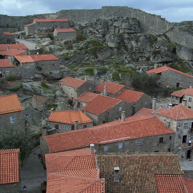
This medieval village sits on a mountain slope where granite dwellings were built directly beneath and between massive boulders. The stone structures use natural rock formations as load bearing walls and sometimes as roofs, creating houses that merge organically with the terrain. Narrow lanes wind between the rock masses that have shaped the village for centuries.
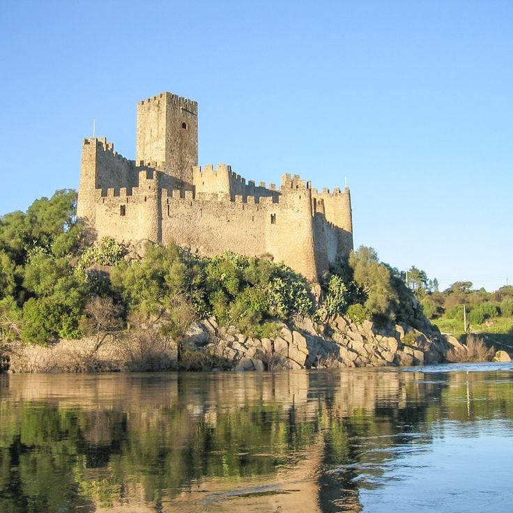
Almourol Castle stands on an island in the Tagus River, about 75 miles (120 kilometers) northeast of Lisbon. High stone walls and nine defensive towers surround a rectangular courtyard, originally built in the 12th century by the Knights Templar. A boat carries visitors to the island. The fortification has preserved its medieval structure and offers views of the river and surrounding plains.
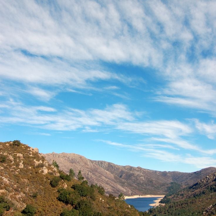
Parc national de Peneda-Gerês extends across the northern mountains and protects oak forests, river valleys and granite villages. Wolves, golden eagles and semi-wild Garrano ponies inhabit the terrain, while trails cross valleys, plateaus and historic stone shelters used by shepherds.
The medieval hilltop village of Sortelha preserves its 12th-century structure with stone houses lining cobbled lanes within fortification walls. A watchtower from the reign of King Dinis rises above granite boulders at the village's highest point near the Spanish border. Romanesque architecture remained largely unchanged through centuries as the village became isolated from trade routes after border conflicts ended. Visitors enter through a Gothic gate marked with two coats of arms and find narrow passages between buildings constructed directly from bedrock.
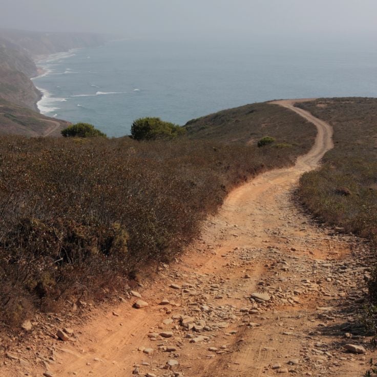
The Rota Vicentina crosses the southwest coast of Portugal through two main routes totaling 280 miles (450 kilometers). The Historical Way runs inland through cork oak forests and rolling hills from Santiago do Cacém to Cape São Vicente. The Fishermen's Trail follows the cliffs directly along the Atlantic from Porto Covo to Odeceixe, in places using old paths once taken by fishermen. The network passes through Southwest Alentejo and Vicentine Coast Natural Park and connects several coastal settlements. Trails are marked and can be walked in daily stages. Vegetation and coastal formations change along the route.
The Livraria Lello in Porto opened in 1906 and displays neo-Gothic woodwork, a curved red staircase spanning two floors, and a glass ceiling that brings natural light into the sales area. The building continues to operate as a bookstore and attracts visitors looking to connect architecture with literature.
Cabo Espichel rises on cliffs jutting above the Atlantic, 12 miles west of Sesimbra. The site includes a nineteenth-century lighthouse, the eighteenth-century pilgrimage church of Nossa Senhora do Cabo with its two pilgrim lodges framing an open square, and fossilized sauropod tracks from the Upper Jurassic visible in limestone layers along the shoreline. The access road cuts through low vegetation to the cape, where wind often blows hard and the sea strikes the rocks below.
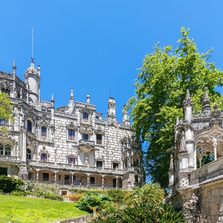
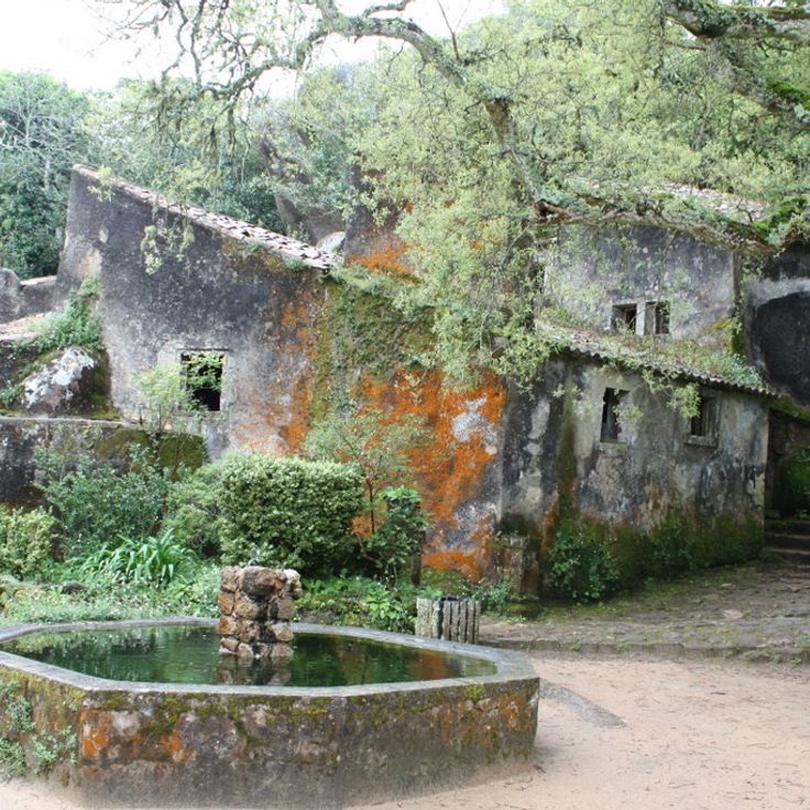
This early 20th-century estate lies on the edge of Sintra, combining architecture with landscaped gardens, underground tunnels and the Initiation Well that descends 89 feet (27 meters) into the earth. The palace was built between 1904 and 1910 to designs by Italian architect Luigi Manini, displaying elements from Gothic, Renaissance and Manueline traditions. The grounds cover nearly 10 acres (4 hectares) and include grottoes, fountains, chapels and hidden passages linked by symbolic references to alchemy and Templar traditions. The spiral well with its nine levels was part of ceremonial initiation rites and opens into an underground network of tunnels.
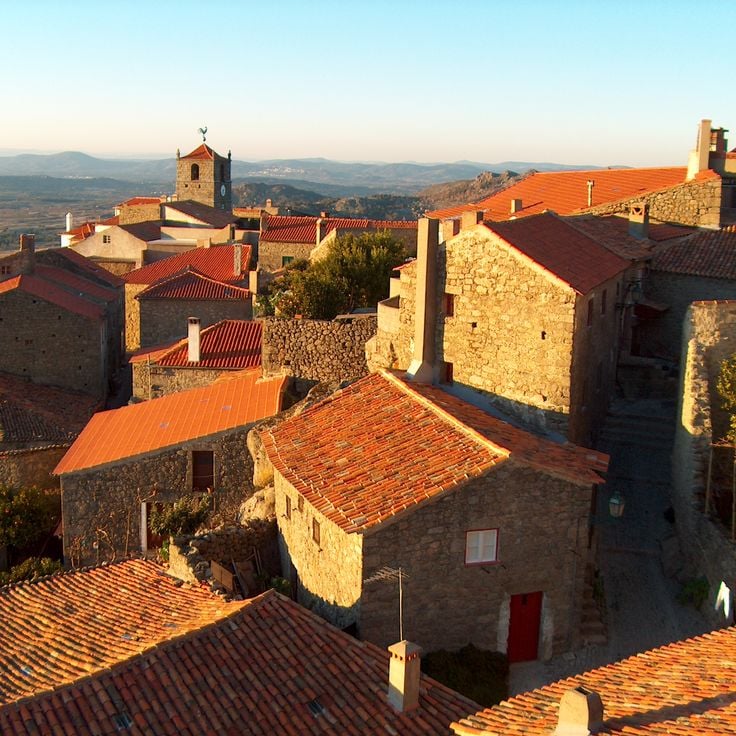
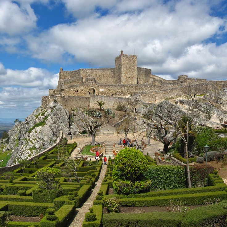
This medieval village stands at 2,838 feet (865 meters) elevation, surrounded by stone walls with views reaching Spain. The fortified settlement rises on a granite peak near the Spanish border. Within the preserved town walls, narrow lanes run between whitewashed houses with iron balconies. The thirteenth-century castle overlooks the village and surrounding plains. From the battlements, views extend across the Alentejo region and the Spanish provinces beyond the border. Several gates lead through the fortifications into the village interior, where squares and small churches are located.
This 11-mile sand barrier island off Tavira offers several beach sections and shallow waters, reached by a short boat ride from the mainland. Ilha de Tavira forms part of the Ria Formosa Natural Park and features a mix of serviced beach areas with facilities and quieter stretches farther east. Camping and simple restaurants cater to visitors during the summer months, while the island sees notably fewer people outside peak season.
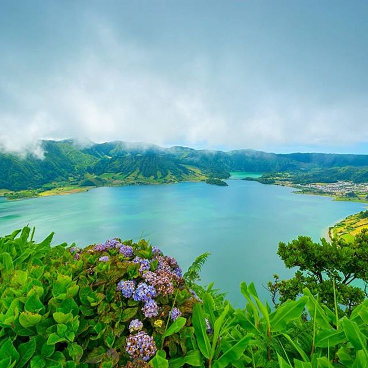
These connected lakes fill a volcanic crater on São Miguel and extend 4.5 kilometers (2.8 miles). The northern lake shows blue water while the southern one appears green due to differing depth and sun exposure. A viewpoint at the crater rim offers views over both bodies of water. Hiking trails run along the shores and connect several villages around the crater.
The Convento dos Capuchos was built in 1560 and features cells lined with cork and stone corridors. The monastery integrates with the granite boulders and forest of the Serra de Sintra. Franciscan friars used materials from the surrounding landscape for the interior spaces, while the architecture follows the natural contours of the site.
The Convent of São Francisco do Monte dates from the 15th century and stands on a hill above Viana do Castelo, its stone walls and terraced gardens preserving evidence of its long history as a Franciscan house. The complex combines architectural simplicity with religious function, and its elevated position provides views across the town and surrounding countryside. The site served for centuries as a place of contemplation and retains the building methods characteristic of late medieval monastic architecture.
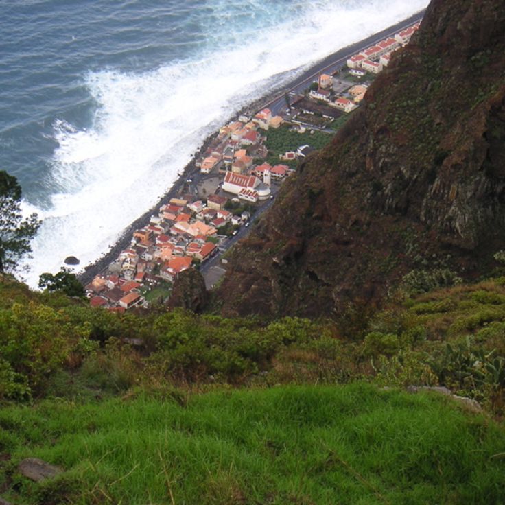
The village sits on Madeira's west coast below steep cliffs. Fishermen work in the small harbor while surfers use the Atlantic waves. A narrow coastal road connects Paul do Mar with surrounding settlements. The village center consists of multi-story residential buildings and a 17th-century church. The exposed location provides consistent ocean conditions throughout the year.
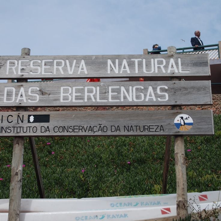
The archipelago consists of granite islands off the coast of Peniche with a 17th-century fortress. Seabirds nest on the cliffs rising above the Atlantic, while underwater caves and clear water mark the coastline. Boats connect the islands to the mainland during summer months.
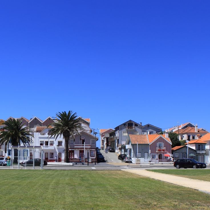
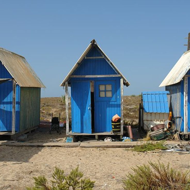
This fishing village on the Atlantic coast displays wooden houses painted with vertical stripes in different colors, originally built as seasonal shelters for fishermen and now forming a distinctive architectural ensemble between the ocean and the Ria de Aveiro.
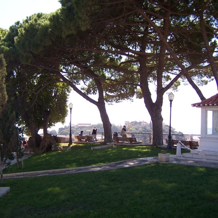
The viewpoint sits on Graça hill and provides a 180-degree view over central Lisbon, including Castelo de São Jorge, the Tagus River and the surrounding neighborhoods. A small chapel next to the platform attracts locals who light candles and leave wishes. The square is reachable via steep streets or tram line 28 and serves as a popular spot for sunsets away from more crowded vantage points.
This thermal station has used mineral water for medical treatments since the 19th century and sits 3 miles (5 kilometers) from the Spanish border. The facility in Beira Baixa offers therapies for rheumatic conditions and respiratory ailments. Water emerges at temperatures between 90 and 106 degrees Fahrenheit (32 to 41 degrees Celsius) and contains sulfates, sodium bicarbonate and other minerals. The complex includes thermal baths, inhalation rooms and medical consultation areas.
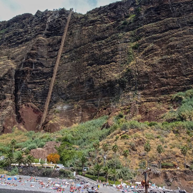
This coastal settlement sits at the base of an 820-foot (250-meter) cliff on Madeira and can only be reached by cable car or boat. The sheltered location allows for wine cultivation on terraced fields maintained by a small community. The steep coastal section shields the area from the interior and creates its own microclimate. Visitors can tour the vineyards that have been tended for generations without direct road access. The site demonstrates a form of agricultural use adapted to Madeira's particular topography.
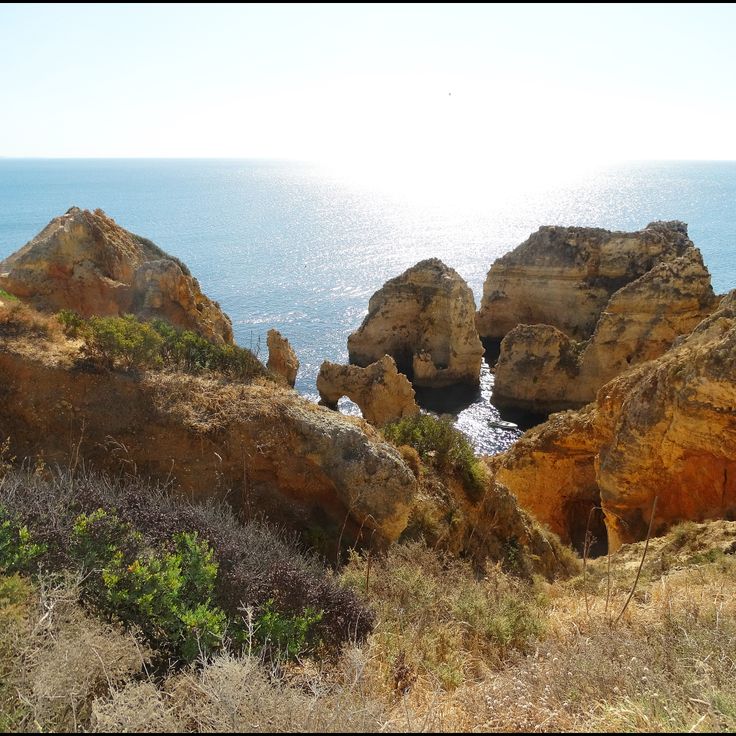
This limestone headland near Lagos forms a coastline of natural arches, rock pillars and sea caves created by thousands of years of wave erosion. Boat excursions navigate through the formations and provide access to smaller grottos unreachable from shore. Stairs connect the clifftop to several viewpoints along the coast.
The Nazaré Canyon extends offshore and ranks among Europe's deepest underwater gorges. This formation reaches depths exceeding 16,400 feet (5,000 meters) and runs close to the coastline. The canyon's topography channels and amplifies Atlantic wave systems, producing exceptionally tall waves during winter months. This phenomenon draws surfers from around the world. The geological structure also influences local fisheries and marine biodiversity.
The Anta Grande do Zambujeiro is a Neolithic megalithic tomb from the fourth millennium BC, ranking among the largest dolmens on the Iberian Peninsula. Its seven upright granite stones reach heights of up to 20 feet (six meters) and once supported a capstone measuring roughly 16 feet (five meters) across. The monument sits in open countryside about eight miles southwest of Évora and remained concealed beneath an earth mound until excavations in the 1960s exposed the structure. The burial chamber served as a ritual space for multiple interments, while archaeological findings indicate agrarian communities engaged in livestock herding. A low corridor leads to the main chamber, which is enclosed by massive orthostats. The recovered artifacts are displayed at the Museum of Évora.
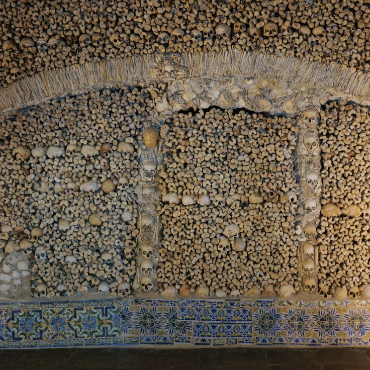
This 16th-century chapel was built by Franciscan monks and features walls and pillars covered with human bones and skulls. The remains came from several local cemeteries, and a Latin inscription above the entrance reminds visitors of life's impermanence. The three-nave interior extends roughly 60 feet (18 meters) in length, and the vaulted ceiling remains white plaster. A small choir area with an altar sits adjacent to the main space.
Ilha Deserta stretches along the Algarve coast as a narrow barrier island and marks the southernmost point of continental Portugal. The uninhabited island receives visitors via regular ferry connections from Faro. A single restaurant operates during the summer months. Dunes and coastal vegetation characterize the landscape, while Atlantic waves reach a shoreline largely free from human development.
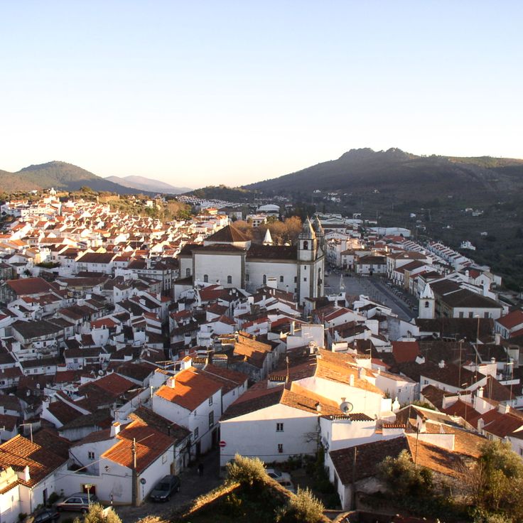
The medieval town of Castelo de Vide sits in northern Alentejo, close to the Spanish border. Its 13th-century Jewish quarter preserves narrow lanes, whitewashed houses and a surviving synagogue. The 13th-century castle rises on a hilltop above the old town, offering views over the surrounding countryside. Multiple springs emerge throughout the town's streets; the Fonte da Mealhada, a marble fountain dating to 1548, has supplied residents and travelers with water for centuries. The historic center displays architecture from different periods, from Gothic doorways to Baroque facades.
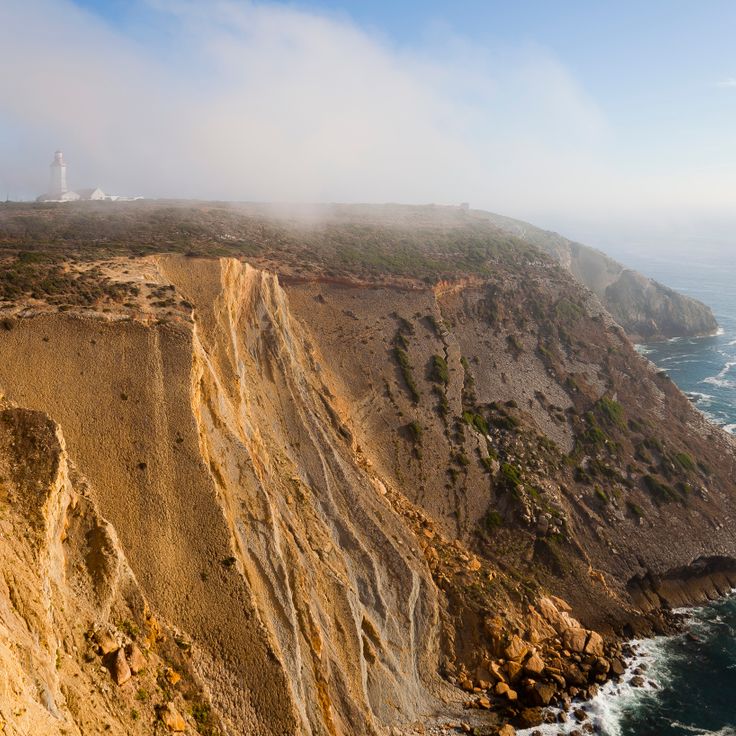
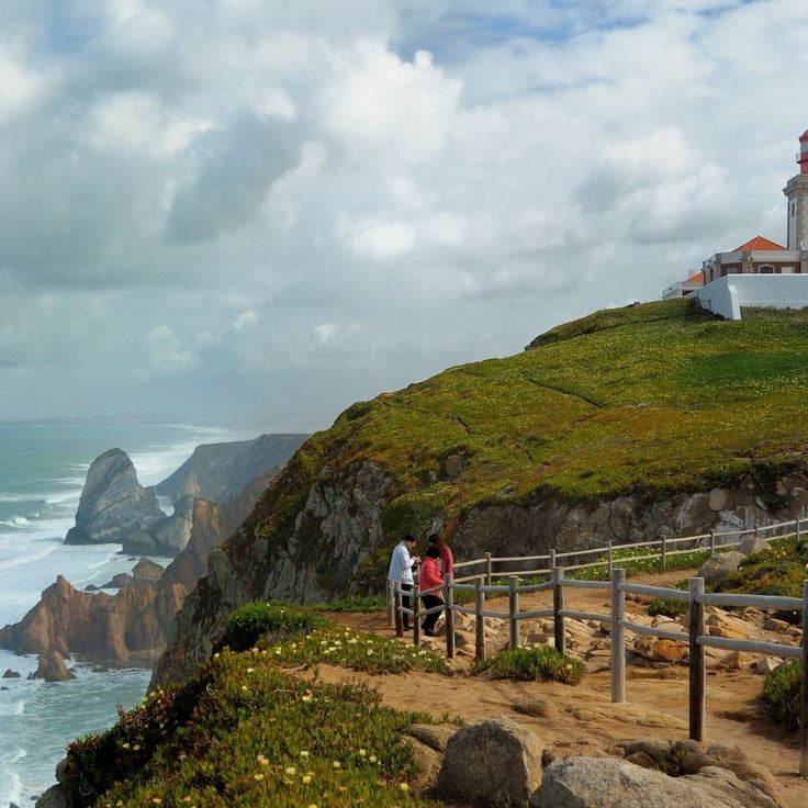
Cabo da Roca occupies cliffs 460 feet (140 meters) above the Atlantic and marks the westernmost point of mainland Portugal and the European continent. A lighthouse dating from 1772 stands beside a stone cross inscribed with lines by poet Luís de Camões. Hiking trails connect the cape to Praia da Adraga and Praia da Ursa beaches and to the coastal sections south of Sintra. At this headland, winds and currents from the open ocean meet the rocky shore, creating heavy surf.
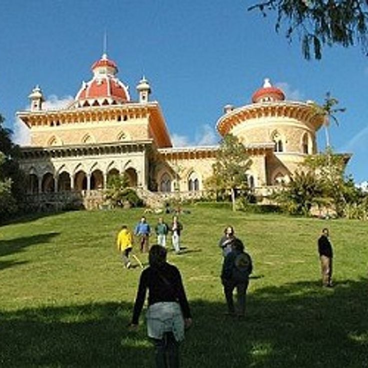
The Palácio de Monserrate combines Moorish, Gothic and Indian architectural elements and sits within an 82-acre (33-hectare) park holding tree species from five continents. The palace took shape in the mid-1800s to designs by architect James Knowles for English merchant Francis Cook, who used the estate as a summer residence. Interior rooms display decorative plasterwork, ornamental ceilings and polychrome tile. The garden is divided into zones featuring plants from Australia, New Zealand, Mexico and Japan, linked by winding paths and small waterfalls. Unlike the more heavily visited palaces such as Pena, Monserrate lies about two miles (three kilometers) outside the center of Sintra.
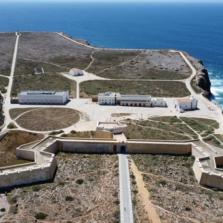
The fortress of Sagres stands at the southwestern tip of continental Europe, 60 meters (200 feet) above the Atlantic. Construction of the current complex began in the 15th century under Prince Henry the Navigator, with later additions following the 1755 earthquake. The walls enclose a plaza featuring a stone compass rose 43 meters (141 feet) in diameter, whose origin and purpose remain debated. The fortress served as a base for expeditions along the African coast and is considered a symbol of Portugal's maritime expansion. The promontory offers views of the cliffs and ocean below.
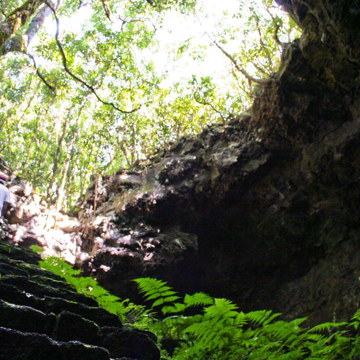
This 3.2-mile lava tunnel formed by prehistoric lava flows contains typical geological formations including stalactites, lava benches and lateral galleries. Gruta das Torres forms the longest cave system in the Azores on the island of Pico. Visitors follow a developed path through the first 1,500 feet (450 meters) of the tunnel, passing different sections where ceiling height varies between 6.5 and 50 feet (2 and 15 meters).
This thermal spring in the laurel forest of Ribeira dos Caldeirões Natural Park maintains a water temperature of 77 degrees Fahrenheit (25 degrees Celsius). The pool feeds from rising geothermal water of volcanic origin, surrounded by ferns, mosses and native plant species of the Azores. A trail leads through the vegetation to the springs, where visitors can bathe in the natural pools. The site lies on the road between Lagoa do Fogo and Ribeira Grande on São Miguel island.
Pico Ruivo reaches 6,109 feet (1,862 meters) in elevation and forms the highest summit on Madeira. From its plateau, views extend across the island's mountain ridges, the northern coast and on clear days to the southern shoreline. A paved hiking trail of approximately 1.7 miles (2.8 kilometers) connects Pico Ruivo with Pico do Arieiro, the island's third highest peak. This path leads through tunnels, over staircases and along ridgelines through the central massif. The shorter approach begins at Achada do Teixeira with a trail of roughly 0.75 miles (1.2 kilometers) to the summit. The area lies within Madeira Natural Park, where heather and endemic plant species grow on the slopes.
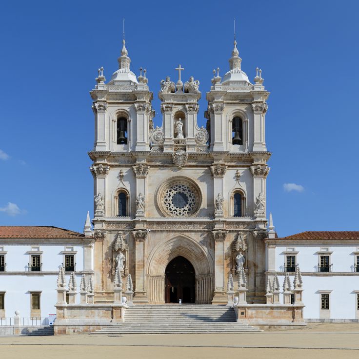
This monastery in the center of Alcobaça ranks among the largest Cistercian structures in Europe and demonstrates the transition of Portuguese church architecture from Romanesque to Gothic style. The complex was founded in 1153 by King Afonso Henriques and developed over the following centuries into an important religious, cultural and economic center. The three-nave church measures over 348 feet (106 m) in length and stands out for its clear proportions and restrained ornamentation. Inside are the tombs of King Pedro I and his mistress Inês de Castro, which rank among the most notable examples of 14th-century Portuguese sculpture. The cloister from the 14th and 15th centuries connects various monastic buildings, including the chapter house, monks' dormitory and the kitchen with its monumental chimney. The site has been a UNESCO World Heritage property since 1989.
This medieval village sits on a mountain slope where granite dwellings were built directly beneath and between massive boulders. The stone structures use natural rock formations as load bearing walls and sometimes as roofs, creating houses that merge organically with the terrain. Narrow lanes wind between the rock masses that have shaped the village for centuries.
Almourol Castle stands on an island in the Tagus River, about 75 miles (120 kilometers) northeast of Lisbon. High stone walls and nine defensive towers surround a rectangular courtyard, originally built in the 12th century by the Knights Templar. A boat carries visitors to the island. The fortification has preserved its medieval structure and offers views of the river and surrounding plains.
Parc national de Peneda-Gerês extends across the northern mountains and protects oak forests, river valleys and granite villages. Wolves, golden eagles and semi-wild Garrano ponies inhabit the terrain, while trails cross valleys, plateaus and historic stone shelters used by shepherds.
The medieval hilltop village of Sortelha preserves its 12th-century structure with stone houses lining cobbled lanes within fortification walls. A watchtower from the reign of King Dinis rises above granite boulders at the village's highest point near the Spanish border. Romanesque architecture remained largely unchanged through centuries as the village became isolated from trade routes after border conflicts ended. Visitors enter through a Gothic gate marked with two coats of arms and find narrow passages between buildings constructed directly from bedrock.
The Rota Vicentina crosses the southwest coast of Portugal through two main routes totaling 280 miles (450 kilometers). The Historical Way runs inland through cork oak forests and rolling hills from Santiago do Cacém to Cape São Vicente. The Fishermen's Trail follows the cliffs directly along the Atlantic from Porto Covo to Odeceixe, in places using old paths once taken by fishermen. The network passes through Southwest Alentejo and Vicentine Coast Natural Park and connects several coastal settlements. Trails are marked and can be walked in daily stages. Vegetation and coastal formations change along the route.
The Livraria Lello in Porto opened in 1906 and displays neo-Gothic woodwork, a curved red staircase spanning two floors, and a glass ceiling that brings natural light into the sales area. The building continues to operate as a bookstore and attracts visitors looking to connect architecture with literature.
Cabo Espichel rises on cliffs jutting above the Atlantic, 12 miles west of Sesimbra. The site includes a nineteenth-century lighthouse, the eighteenth-century pilgrimage church of Nossa Senhora do Cabo with its two pilgrim lodges framing an open square, and fossilized sauropod tracks from the Upper Jurassic visible in limestone layers along the shoreline. The access road cuts through low vegetation to the cape, where wind often blows hard and the sea strikes the rocks below.
This early 20th-century estate lies on the edge of Sintra, combining architecture with landscaped gardens, underground tunnels and the Initiation Well that descends 89 feet (27 meters) into the earth. The palace was built between 1904 and 1910 to designs by Italian architect Luigi Manini, displaying elements from Gothic, Renaissance and Manueline traditions. The grounds cover nearly 10 acres (4 hectares) and include grottoes, fountains, chapels and hidden passages linked by symbolic references to alchemy and Templar traditions. The spiral well with its nine levels was part of ceremonial initiation rites and opens into an underground network of tunnels.
This medieval village stands at 2,838 feet (865 meters) elevation, surrounded by stone walls with views reaching Spain. The fortified settlement rises on a granite peak near the Spanish border. Within the preserved town walls, narrow lanes run between whitewashed houses with iron balconies. The thirteenth-century castle overlooks the village and surrounding plains. From the battlements, views extend across the Alentejo region and the Spanish provinces beyond the border. Several gates lead through the fortifications into the village interior, where squares and small churches are located.
This 11-mile sand barrier island off Tavira offers several beach sections and shallow waters, reached by a short boat ride from the mainland. Ilha de Tavira forms part of the Ria Formosa Natural Park and features a mix of serviced beach areas with facilities and quieter stretches farther east. Camping and simple restaurants cater to visitors during the summer months, while the island sees notably fewer people outside peak season.
These connected lakes fill a volcanic crater on São Miguel and extend 4.5 kilometers (2.8 miles). The northern lake shows blue water while the southern one appears green due to differing depth and sun exposure. A viewpoint at the crater rim offers views over both bodies of water. Hiking trails run along the shores and connect several villages around the crater.
The Convento dos Capuchos was built in 1560 and features cells lined with cork and stone corridors. The monastery integrates with the granite boulders and forest of the Serra de Sintra. Franciscan friars used materials from the surrounding landscape for the interior spaces, while the architecture follows the natural contours of the site.
The Convent of São Francisco do Monte dates from the 15th century and stands on a hill above Viana do Castelo, its stone walls and terraced gardens preserving evidence of its long history as a Franciscan house. The complex combines architectural simplicity with religious function, and its elevated position provides views across the town and surrounding countryside. The site served for centuries as a place of contemplation and retains the building methods characteristic of late medieval monastic architecture.
The village sits on Madeira's west coast below steep cliffs. Fishermen work in the small harbor while surfers use the Atlantic waves. A narrow coastal road connects Paul do Mar with surrounding settlements. The village center consists of multi-story residential buildings and a 17th-century church. The exposed location provides consistent ocean conditions throughout the year.
The archipelago consists of granite islands off the coast of Peniche with a 17th-century fortress. Seabirds nest on the cliffs rising above the Atlantic, while underwater caves and clear water mark the coastline. Boats connect the islands to the mainland during summer months.
This fishing village on the Atlantic coast displays wooden houses painted with vertical stripes in different colors, originally built as seasonal shelters for fishermen and now forming a distinctive architectural ensemble between the ocean and the Ria de Aveiro.
The viewpoint sits on Graça hill and provides a 180-degree view over central Lisbon, including Castelo de São Jorge, the Tagus River and the surrounding neighborhoods. A small chapel next to the platform attracts locals who light candles and leave wishes. The square is reachable via steep streets or tram line 28 and serves as a popular spot for sunsets away from more crowded vantage points.
This thermal station has used mineral water for medical treatments since the 19th century and sits 3 miles (5 kilometers) from the Spanish border. The facility in Beira Baixa offers therapies for rheumatic conditions and respiratory ailments. Water emerges at temperatures between 90 and 106 degrees Fahrenheit (32 to 41 degrees Celsius) and contains sulfates, sodium bicarbonate and other minerals. The complex includes thermal baths, inhalation rooms and medical consultation areas.
This coastal settlement sits at the base of an 820-foot (250-meter) cliff on Madeira and can only be reached by cable car or boat. The sheltered location allows for wine cultivation on terraced fields maintained by a small community. The steep coastal section shields the area from the interior and creates its own microclimate. Visitors can tour the vineyards that have been tended for generations without direct road access. The site demonstrates a form of agricultural use adapted to Madeira's particular topography.
This limestone headland near Lagos forms a coastline of natural arches, rock pillars and sea caves created by thousands of years of wave erosion. Boat excursions navigate through the formations and provide access to smaller grottos unreachable from shore. Stairs connect the clifftop to several viewpoints along the coast.
The Nazaré Canyon extends offshore and ranks among Europe's deepest underwater gorges. This formation reaches depths exceeding 16,400 feet (5,000 meters) and runs close to the coastline. The canyon's topography channels and amplifies Atlantic wave systems, producing exceptionally tall waves during winter months. This phenomenon draws surfers from around the world. The geological structure also influences local fisheries and marine biodiversity.
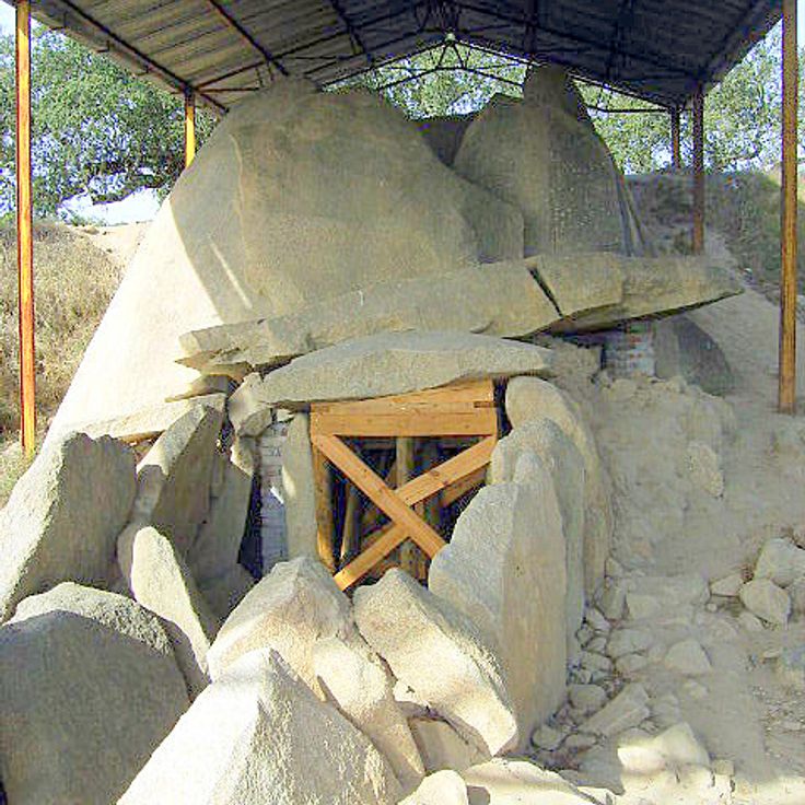
The Anta Grande do Zambujeiro is a Neolithic megalithic tomb from the fourth millennium BC, ranking among the largest dolmens on the Iberian Peninsula. Its seven upright granite stones reach heights of up to 20 feet (six meters) and once supported a capstone measuring roughly 16 feet (five meters) across. The monument sits in open countryside about eight miles southwest of Évora and remained concealed beneath an earth mound until excavations in the 1960s exposed the structure. The burial chamber served as a ritual space for multiple interments, while archaeological findings indicate agrarian communities engaged in livestock herding. A low corridor leads to the main chamber, which is enclosed by massive orthostats. The recovered artifacts are displayed at the Museum of Évora.
This 16th-century chapel was built by Franciscan monks and features walls and pillars covered with human bones and skulls. The remains came from several local cemeteries, and a Latin inscription above the entrance reminds visitors of life's impermanence. The three-nave interior extends roughly 60 feet (18 meters) in length, and the vaulted ceiling remains white plaster. A small choir area with an altar sits adjacent to the main space.
Ilha Deserta stretches along the Algarve coast as a narrow barrier island and marks the southernmost point of continental Portugal. The uninhabited island receives visitors via regular ferry connections from Faro. A single restaurant operates during the summer months. Dunes and coastal vegetation characterize the landscape, while Atlantic waves reach a shoreline largely free from human development.
The medieval town of Castelo de Vide sits in northern Alentejo, close to the Spanish border. Its 13th-century Jewish quarter preserves narrow lanes, whitewashed houses and a surviving synagogue. The 13th-century castle rises on a hilltop above the old town, offering views over the surrounding countryside. Multiple springs emerge throughout the town's streets; the Fonte da Mealhada, a marble fountain dating to 1548, has supplied residents and travelers with water for centuries. The historic center displays architecture from different periods, from Gothic doorways to Baroque facades.
Cabo da Roca occupies cliffs 460 feet (140 meters) above the Atlantic and marks the westernmost point of mainland Portugal and the European continent. A lighthouse dating from 1772 stands beside a stone cross inscribed with lines by poet Luís de Camões. Hiking trails connect the cape to Praia da Adraga and Praia da Ursa beaches and to the coastal sections south of Sintra. At this headland, winds and currents from the open ocean meet the rocky shore, creating heavy surf.
The Palácio de Monserrate combines Moorish, Gothic and Indian architectural elements and sits within an 82-acre (33-hectare) park holding tree species from five continents. The palace took shape in the mid-1800s to designs by architect James Knowles for English merchant Francis Cook, who used the estate as a summer residence. Interior rooms display decorative plasterwork, ornamental ceilings and polychrome tile. The garden is divided into zones featuring plants from Australia, New Zealand, Mexico and Japan, linked by winding paths and small waterfalls. Unlike the more heavily visited palaces such as Pena, Monserrate lies about two miles (three kilometers) outside the center of Sintra.
The fortress of Sagres stands at the southwestern tip of continental Europe, 60 meters (200 feet) above the Atlantic. Construction of the current complex began in the 15th century under Prince Henry the Navigator, with later additions following the 1755 earthquake. The walls enclose a plaza featuring a stone compass rose 43 meters (141 feet) in diameter, whose origin and purpose remain debated. The fortress served as a base for expeditions along the African coast and is considered a symbol of Portugal's maritime expansion. The promontory offers views of the cliffs and ocean below.
This 3.2-mile lava tunnel formed by prehistoric lava flows contains typical geological formations including stalactites, lava benches and lateral galleries. Gruta das Torres forms the longest cave system in the Azores on the island of Pico. Visitors follow a developed path through the first 1,500 feet (450 meters) of the tunnel, passing different sections where ceiling height varies between 6.5 and 50 feet (2 and 15 meters).
This thermal spring in the laurel forest of Ribeira dos Caldeirões Natural Park maintains a water temperature of 77 degrees Fahrenheit (25 degrees Celsius). The pool feeds from rising geothermal water of volcanic origin, surrounded by ferns, mosses and native plant species of the Azores. A trail leads through the vegetation to the springs, where visitors can bathe in the natural pools. The site lies on the road between Lagoa do Fogo and Ribeira Grande on São Miguel island.
Pico Ruivo reaches 6,109 feet (1,862 meters) in elevation and forms the highest summit on Madeira. From its plateau, views extend across the island's mountain ridges, the northern coast and on clear days to the southern shoreline. A paved hiking trail of approximately 1.7 miles (2.8 kilometers) connects Pico Ruivo with Pico do Arieiro, the island's third highest peak. This path leads through tunnels, over staircases and along ridgelines through the central massif. The shorter approach begins at Achada do Teixeira with a trail of roughly 0.75 miles (1.2 kilometers) to the summit. The area lies within Madeira Natural Park, where heather and endemic plant species grow on the slopes.
This monastery in the center of Alcobaça ranks among the largest Cistercian structures in Europe and demonstrates the transition of Portuguese church architecture from Romanesque to Gothic style. The complex was founded in 1153 by King Afonso Henriques and developed over the following centuries into an important religious, cultural and economic center. The three-nave church measures over 348 feet (106 m) in length and stands out for its clear proportions and restrained ornamentation. Inside are the tombs of King Pedro I and his mistress Inês de Castro, which rank among the most notable examples of 14th-century Portuguese sculpture. The cloister from the 14th and 15th centuries connects various monastic buildings, including the chapter house, monks' dormitory and the kitchen with its monumental chimney. The site has been a UNESCO World Heritage property since 1989.
This medieval village sits on a mountain slope where granite dwellings were built directly beneath and between massive boulders. The stone structures use natural rock formations as load bearing walls and sometimes as roofs, creating houses that merge organically with the terrain. Narrow lanes wind between the rock masses that have shaped the village for centuries.
Almourol Castle stands on an island in the Tagus River, about 75 miles (120 kilometers) northeast of Lisbon. High stone walls and nine defensive towers surround a rectangular courtyard, originally built in the 12th century by the Knights Templar. A boat carries visitors to the island. The fortification has preserved its medieval structure and offers views of the river and surrounding plains.
Parc national de Peneda-Gerês extends across the northern mountains and protects oak forests, river valleys and granite villages. Wolves, golden eagles and semi-wild Garrano ponies inhabit the terrain, while trails cross valleys, plateaus and historic stone shelters used by shepherds.
The medieval hilltop village of Sortelha preserves its 12th-century structure with stone houses lining cobbled lanes within fortification walls. A watchtower from the reign of King Dinis rises above granite boulders at the village's highest point near the Spanish border. Romanesque architecture remained largely unchanged through centuries as the village became isolated from trade routes after border conflicts ended. Visitors enter through a Gothic gate marked with two coats of arms and find narrow passages between buildings constructed directly from bedrock.
The Rota Vicentina crosses the southwest coast of Portugal through two main routes totaling 280 miles (450 kilometers). The Historical Way runs inland through cork oak forests and rolling hills from Santiago do Cacém to Cape São Vicente. The Fishermen's Trail follows the cliffs directly along the Atlantic from Porto Covo to Odeceixe, in places using old paths once taken by fishermen. The network passes through Southwest Alentejo and Vicentine Coast Natural Park and connects several coastal settlements. Trails are marked and can be walked in daily stages. Vegetation and coastal formations change along the route.
The Livraria Lello in Porto opened in 1906 and displays neo-Gothic woodwork, a curved red staircase spanning two floors, and a glass ceiling that brings natural light into the sales area. The building continues to operate as a bookstore and attracts visitors looking to connect architecture with literature.
Cabo Espichel rises on cliffs jutting above the Atlantic, 12 miles west of Sesimbra. The site includes a nineteenth-century lighthouse, the eighteenth-century pilgrimage church of Nossa Senhora do Cabo with its two pilgrim lodges framing an open square, and fossilized sauropod tracks from the Upper Jurassic visible in limestone layers along the shoreline. The access road cuts through low vegetation to the cape, where wind often blows hard and the sea strikes the rocks below.
This early 20th-century estate lies on the edge of Sintra, combining architecture with landscaped gardens, underground tunnels and the Initiation Well that descends 89 feet (27 meters) into the earth. The palace was built between 1904 and 1910 to designs by Italian architect Luigi Manini, displaying elements from Gothic, Renaissance and Manueline traditions. The grounds cover nearly 10 acres (4 hectares) and include grottoes, fountains, chapels and hidden passages linked by symbolic references to alchemy and Templar traditions. The spiral well with its nine levels was part of ceremonial initiation rites and opens into an underground network of tunnels.
This medieval village stands at 2,838 feet (865 meters) elevation, surrounded by stone walls with views reaching Spain. The fortified settlement rises on a granite peak near the Spanish border. Within the preserved town walls, narrow lanes run between whitewashed houses with iron balconies. The thirteenth-century castle overlooks the village and surrounding plains. From the battlements, views extend across the Alentejo region and the Spanish provinces beyond the border. Several gates lead through the fortifications into the village interior, where squares and small churches are located.
This 11-mile sand barrier island off Tavira offers several beach sections and shallow waters, reached by a short boat ride from the mainland. Ilha de Tavira forms part of the Ria Formosa Natural Park and features a mix of serviced beach areas with facilities and quieter stretches farther east. Camping and simple restaurants cater to visitors during the summer months, while the island sees notably fewer people outside peak season.
These connected lakes fill a volcanic crater on São Miguel and extend 4.5 kilometers (2.8 miles). The northern lake shows blue water while the southern one appears green due to differing depth and sun exposure. A viewpoint at the crater rim offers views over both bodies of water. Hiking trails run along the shores and connect several villages around the crater.
The Convento dos Capuchos was built in 1560 and features cells lined with cork and stone corridors. The monastery integrates with the granite boulders and forest of the Serra de Sintra. Franciscan friars used materials from the surrounding landscape for the interior spaces, while the architecture follows the natural contours of the site.
The Convent of São Francisco do Monte dates from the 15th century and stands on a hill above Viana do Castelo, its stone walls and terraced gardens preserving evidence of its long history as a Franciscan house. The complex combines architectural simplicity with religious function, and its elevated position provides views across the town and surrounding countryside. The site served for centuries as a place of contemplation and retains the building methods characteristic of late medieval monastic architecture.
The village sits on Madeira's west coast below steep cliffs. Fishermen work in the small harbor while surfers use the Atlantic waves. A narrow coastal road connects Paul do Mar with surrounding settlements. The village center consists of multi-story residential buildings and a 17th-century church. The exposed location provides consistent ocean conditions throughout the year.
The archipelago consists of granite islands off the coast of Peniche with a 17th-century fortress. Seabirds nest on the cliffs rising above the Atlantic, while underwater caves and clear water mark the coastline. Boats connect the islands to the mainland during summer months.
This fishing village on the Atlantic coast displays wooden houses painted with vertical stripes in different colors, originally built as seasonal shelters for fishermen and now forming a distinctive architectural ensemble between the ocean and the Ria de Aveiro.
The viewpoint sits on Graça hill and provides a 180-degree view over central Lisbon, including Castelo de São Jorge, the Tagus River and the surrounding neighborhoods. A small chapel next to the platform attracts locals who light candles and leave wishes. The square is reachable via steep streets or tram line 28 and serves as a popular spot for sunsets away from more crowded vantage points.
This thermal station has used mineral water for medical treatments since the 19th century and sits 3 miles (5 kilometers) from the Spanish border. The facility in Beira Baixa offers therapies for rheumatic conditions and respiratory ailments. Water emerges at temperatures between 90 and 106 degrees Fahrenheit (32 to 41 degrees Celsius) and contains sulfates, sodium bicarbonate and other minerals. The complex includes thermal baths, inhalation rooms and medical consultation areas.
This coastal settlement sits at the base of an 820-foot (250-meter) cliff on Madeira and can only be reached by cable car or boat. The sheltered location allows for wine cultivation on terraced fields maintained by a small community. The steep coastal section shields the area from the interior and creates its own microclimate. Visitors can tour the vineyards that have been tended for generations without direct road access. The site demonstrates a form of agricultural use adapted to Madeira's particular topography.
This limestone headland near Lagos forms a coastline of natural arches, rock pillars and sea caves created by thousands of years of wave erosion. Boat excursions navigate through the formations and provide access to smaller grottos unreachable from shore. Stairs connect the clifftop to several viewpoints along the coast.
The Nazaré Canyon extends offshore and ranks among Europe's deepest underwater gorges. This formation reaches depths exceeding 16,400 feet (5,000 meters) and runs close to the coastline. The canyon's topography channels and amplifies Atlantic wave systems, producing exceptionally tall waves during winter months. This phenomenon draws surfers from around the world. The geological structure also influences local fisheries and marine biodiversity.
The Anta Grande do Zambujeiro is a Neolithic megalithic tomb from the fourth millennium BC, ranking among the largest dolmens on the Iberian Peninsula. Its seven upright granite stones reach heights of up to 20 feet (six meters) and once supported a capstone measuring roughly 16 feet (five meters) across. The monument sits in open countryside about eight miles southwest of Évora and remained concealed beneath an earth mound until excavations in the 1960s exposed the structure. The burial chamber served as a ritual space for multiple interments, while archaeological findings indicate agrarian communities engaged in livestock herding. A low corridor leads to the main chamber, which is enclosed by massive orthostats. The recovered artifacts are displayed at the Museum of Évora.
This 16th-century chapel was built by Franciscan monks and features walls and pillars covered with human bones and skulls. The remains came from several local cemeteries, and a Latin inscription above the entrance reminds visitors of life's impermanence. The three-nave interior extends roughly 60 feet (18 meters) in length, and the vaulted ceiling remains white plaster. A small choir area with an altar sits adjacent to the main space.
Ilha Deserta stretches along the Algarve coast as a narrow barrier island and marks the southernmost point of continental Portugal. The uninhabited island receives visitors via regular ferry connections from Faro. A single restaurant operates during the summer months. Dunes and coastal vegetation characterize the landscape, while Atlantic waves reach a shoreline largely free from human development.
The medieval town of Castelo de Vide sits in northern Alentejo, close to the Spanish border. Its 13th-century Jewish quarter preserves narrow lanes, whitewashed houses and a surviving synagogue. The 13th-century castle rises on a hilltop above the old town, offering views over the surrounding countryside. Multiple springs emerge throughout the town's streets; the Fonte da Mealhada, a marble fountain dating to 1548, has supplied residents and travelers with water for centuries. The historic center displays architecture from different periods, from Gothic doorways to Baroque facades.
Cabo da Roca occupies cliffs 460 feet (140 meters) above the Atlantic and marks the westernmost point of mainland Portugal and the European continent. A lighthouse dating from 1772 stands beside a stone cross inscribed with lines by poet Luís de Camões. Hiking trails connect the cape to Praia da Adraga and Praia da Ursa beaches and to the coastal sections south of Sintra. At this headland, winds and currents from the open ocean meet the rocky shore, creating heavy surf.
The Palácio de Monserrate combines Moorish, Gothic and Indian architectural elements and sits within an 82-acre (33-hectare) park holding tree species from five continents. The palace took shape in the mid-1800s to designs by architect James Knowles for English merchant Francis Cook, who used the estate as a summer residence. Interior rooms display decorative plasterwork, ornamental ceilings and polychrome tile. The garden is divided into zones featuring plants from Australia, New Zealand, Mexico and Japan, linked by winding paths and small waterfalls. Unlike the more heavily visited palaces such as Pena, Monserrate lies about two miles (three kilometers) outside the center of Sintra.
The fortress of Sagres stands at the southwestern tip of continental Europe, 60 meters (200 feet) above the Atlantic. Construction of the current complex began in the 15th century under Prince Henry the Navigator, with later additions following the 1755 earthquake. The walls enclose a plaza featuring a stone compass rose 43 meters (141 feet) in diameter, whose origin and purpose remain debated. The fortress served as a base for expeditions along the African coast and is considered a symbol of Portugal's maritime expansion. The promontory offers views of the cliffs and ocean below.
This 3.2-mile lava tunnel formed by prehistoric lava flows contains typical geological formations including stalactites, lava benches and lateral galleries. Gruta das Torres forms the longest cave system in the Azores on the island of Pico. Visitors follow a developed path through the first 1,500 feet (450 meters) of the tunnel, passing different sections where ceiling height varies between 6.5 and 50 feet (2 and 15 meters).
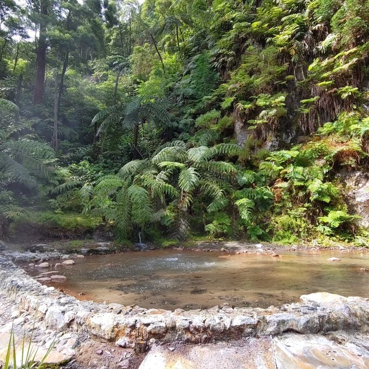
This thermal spring in the laurel forest of Ribeira dos Caldeirões Natural Park maintains a water temperature of 77 degrees Fahrenheit (25 degrees Celsius). The pool feeds from rising geothermal water of volcanic origin, surrounded by ferns, mosses and native plant species of the Azores. A trail leads through the vegetation to the springs, where visitors can bathe in the natural pools. The site lies on the road between Lagoa do Fogo and Ribeira Grande on São Miguel island.
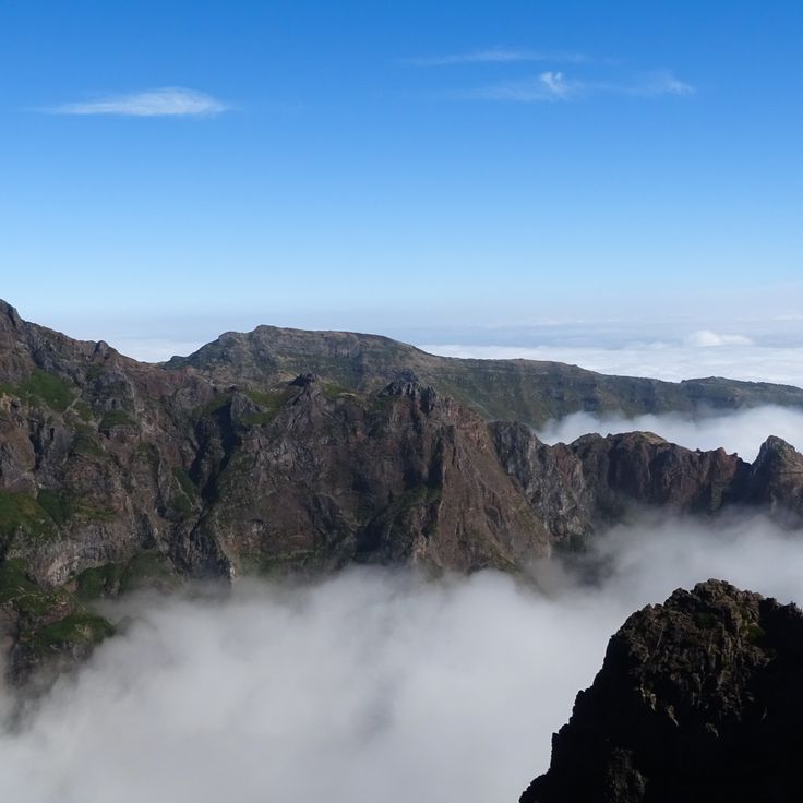
Pico Ruivo reaches 6,109 feet (1,862 meters) in elevation and forms the highest summit on Madeira. From its plateau, views extend across the island's mountain ridges, the northern coast and on clear days to the southern shoreline. A paved hiking trail of approximately 1.7 miles (2.8 kilometers) connects Pico Ruivo with Pico do Arieiro, the island's third highest peak. This path leads through tunnels, over staircases and along ridgelines through the central massif. The shorter approach begins at Achada do Teixeira with a trail of roughly 0.75 miles (1.2 kilometers) to the summit. The area lies within Madeira Natural Park, where heather and endemic plant species grow on the slopes.
This monastery in the center of Alcobaça ranks among the largest Cistercian structures in Europe and demonstrates the transition of Portuguese church architecture from Romanesque to Gothic style. The complex was founded in 1153 by King Afonso Henriques and developed over the following centuries into an important religious, cultural and economic center. The three-nave church measures over 348 feet (106 m) in length and stands out for its clear proportions and restrained ornamentation. Inside are the tombs of King Pedro I and his mistress Inês de Castro, which rank among the most notable examples of 14th-century Portuguese sculpture. The cloister from the 14th and 15th centuries connects various monastic buildings, including the chapter house, monks' dormitory and the kitchen with its monumental chimney. The site has been a UNESCO World Heritage property since 1989.