Enable Location

We need your location to show you interesting places around you

Discover nearby places

Find interesting locations and hidden gems around you

Precise directions

Get accurate directions and distances to places

Your location is never shared with other users. It's only used when you tap the location button.

Skydive West Plains

Log in to your account

Start exploring — it's free

Trusted by 62,340 travelers worldwide

Continue with Google
Continue with Apple
or

We will send you a code to connect

By continuing, you accept our Terms and Conditions and our Privacy Policy

Check your inbox

We've sent a pincode in your inbox. Please enter the code below.

Skydive West Plains

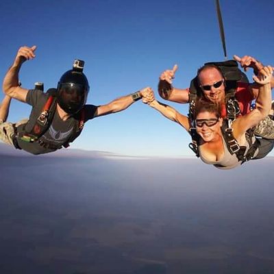
Skydive West Plains, Skydiving center in Ritzville, Washington, US

Skydive West Plains is a skydiving center operating from Monkey/Lund Field using a Cessna Caravan aircraft to take jumpers aloft. The aircraft climbs to approximately 10,000 feet (3,000 meters), providing the altitude needed for freefall and parachute deployment.

The center began as a small regional operation and grew into a certified training facility offering structured jump programs. It now serves both novice jumpers and experienced skydivers seeking advanced techniques.

Skydive West Plains functions as a gathering point for adventure sports enthusiasts, where experienced skydivers practice formation diving, freeflying, and wingsuiting techniques.

Visitors must be at least 18 years old and bring valid government identification to participate. The facility checks weight-to-height ratios to ensure safety requirements are met before any jump.

The facility hosts special events like weddings and corporate celebrations where participants can combine adventure with memorable occasions. These customized jumps create once-in-a-lifetime moments for couples and groups.

The community of curious travelers

AroundUs brings together thousands of curated places, local tips, and hidden gems, enriched daily by 60,000 contributors worldwide.

Start exploring
Location
Address
Schoessler Road
Opening Hours
Monday 09:00-19:00; Thursday-Sunday 09:00-19:00
Phone
GPS coordinates
47.16079,-118.29000
Latest update
December 9, 2025 20:28
Around this place
Palouse Falls
United States of America

Palouse Falls

55.6 km
Mullan Road
United States of America

Mullan Road

44.1 km
Marmes Rockshelter
United States of America

Marmes Rockshelter

61.2 km
Palouse Falls State Park
United States of America

Palouse Falls State Park

55.2 km
Crab Creek
United States of America

Crab Creek

37.8 km
Turnbull National Wildlife Refuge
United States of America

Turnbull National Wildlife Refuge

62 km
Columbia Plateau State Park Trail
United States of America

Columbia Plateau State Park Trail

60.9 km
Abraham Lincoln
United States of America

Abraham Lincoln

67.9 km
Little Goose Dam
United States of America

Little Goose Dam

66.9 km
Lower Monumental Dam
United States of America

Lower Monumental Dam

69.2 km
Steptoe Battlefield State Park Heritage Site
United States of America

Steptoe Battlefield State Park Heritage Site

70.4 km
Snake River Bridge
United States of America

Snake River Bridge

63.8 km
Mary Queen of Heaven Roman Catholic Church
United States of America

Mary Queen of Heaven Roman Catholic Church

28.6 km
Manning-Rye Covered Bridge
United States of America

Manning-Rye Covered Bridge

71.2 km
Joso High Bridge
United States of America

Joso High Bridge

63.3 km
Rosalia Railroad Bridge
United States of America

Rosalia Railroad Bridge

70.5 km
Rock Creek
United States of America

Rock Creek

41.6 km
Riparia Bridge
United States of America

Riparia Bridge

67 km
Harrington Bank Block & Opera House
United States of America

Harrington Bank Block & Opera House

35.6 km
Dr. Frank R. Burroughs House
United States of America

Dr. Frank R. Burroughs House

8.1 km
Nelson H. Greene House
United States of America

Nelson H. Greene House

7.7 km
Ritzville Historic District
United States of America

Ritzville Historic District

7.7 km
Cheney Odd Fellows Hall
United States of America

Cheney Odd Fellows Hall

65 km
Ritzville Carnegie Library
United States of America

Ritzville Carnegie Library

8 km
Lyons Ferry State Park
United States of America

Lyons Ferry State Park

60 km
Seivers Brothers Ranchhouse and Barn
United States of America

Seivers Brothers Ranchhouse and Barn

32.2 km
BiMart Arena - Cheney Rodeo
United States of America

BiMart Arena - Cheney Rodeo

67.9 km
Ritzville Water Park
United States of America

Ritzville Water Park

7.4 km
Show the full map
« Skydive West Plains - Skydiving center in Ritzville, Washington, US » is provided by Around Us (aroundus.com). Images and texts are derived from Wikimedia project under a Creative Commons license. You are allowed to copy, distribute, and modify copies of this page, under the conditions set by the license, as long as this note is clearly visible.

Discover hidden gems everywhere you go!

From secret cafés to breathtaking viewpoints, skip the crowded tourist spots and find places that match your style. Our app makes it easy with voice search, smart filtering, route optimization, and insider tips from travelers worldwide. Download now for the complete mobile experience.

Around Us App Screenshot

A unique approach to discovering new places

Le Figaro

All the places worth exploring

France Info

A tailor-made excursion in just a few clicks

20 Minutes

Around Us
Travel Guide & Maps
Download

Send to your phone

QR Code
1

Open the camera app on your mobile.

2

Point at the QR code with your camera. A notification will appear.

3

Tap the notification to open the link.