Náměšť nad Oslavou

Log in to your account

AroundUs is a community-driven map of interesting places, built by curious explorers like you. It grows with every review, story, and photo you share.
Connect to save your favorite spots, contribute locations, and create personalized routes.
By continuing, you accept our Terms and Conditions and our Privacy Policy
Add to collection
Map
Suggest a change
Share

Náměšť nad Oslavou, Historical municipality in Třebíč District, Czech Republic.

Náměšť nad Oslavou is a historic municipality in Třebíč District that lines the Oslava River at about 365 meters elevation, featuring Renaissance buildings and gardens throughout its layout. The town combines medieval architectural elements with its natural riverside setting in the South Moravian region.

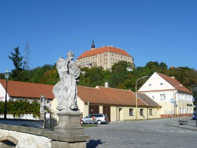
The town appears in written records from 1234 when it belonged to the lords of Lomnice during the medieval period of regional trade routes. The castle became a center of power and commerce in the area, shaping the settlement's growth and importance.

The Folk Holidays festival brings visitors to experience traditional music and local crafts performed annually at the Renaissance castle grounds. The event shows how the town values and celebrates its regional heritage through live performances and cultural exchange.

The town is well connected to major cities like Brno and Plzeň through route I/23 and a railway line with regular year-round service. The location also provides access to hiking and cycling paths along the Oslava River valley for exploring the surrounding countryside.

The castle library holds around 16,000 books including rare historical prints and manuscript collections that offer insight into the knowledge and learning of past centuries. This collection makes the place a quiet stop for book lovers and those interested in regional history.

Location: Třebíč District

Location: upravni občinski okoliš z razširjenimi pristojnostmi Náměšť nad Oslavou

Elevation above the sea: 365 m

Shares border with: Ocmanice, Vícenice u Náměště nad Oslavou, Březník, Hluboké, Kralice nad Oslavou, Jinošov, Pucov, Naloučany, Sedlec

Email: podatelna@mesto-namest.cz

Website: http://namestnosl.cz

GPS coordinates: 49.20730,16.15850

Latest update: December 7, 2025 20:43

Photos
Reviews

Visited this place? Tap the stars to rate it and share your experience / photos with the community! Try now! You can cancel it anytime.

« Náměšť nad Oslavou - Historical municipality in Třebíč District, Czech Republic » is provided by Around Us (aroundus.com). Images and texts are derived from Wikimedia project under a Creative Commons license. You are allowed to copy, distribute, and modify copies of this page, under the conditions set by the license, as long as this note is clearly visible.

Discover hidden gems everywhere you go!

From secret cafés to breathtaking viewpoints, skip the crowded tourist spots and find places that match your style. Our app makes it easy with voice search, smart filtering, route optimization, and insider tips from travelers worldwide. Download now for the complete mobile experience.

Around Us App Screenshot

A unique approach to discovering new places

Le Figaro

All the places worth exploring

France Info

A tailor-made excursion in just a few clicks

20 Minutes