Adhaim Dam, Embankment dam in Salah ad Din Governorate, Iraq.
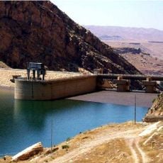
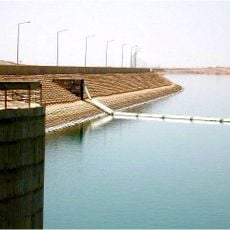
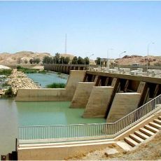
Adhaim Dam is a 3,800 m long earth-fill embankment dam with a clay core on the Al Uzaym River, 133 km northeast of Baghdad. Its body rises 76.5 m with a 12 m crest, and a free ungated spillway with a crest at 131.5 m above sea level can pass 1,150 m³/s. A 50 m intake tower feeds a 4.5 m diameter, 310 m steel- and concrete-lined tunnel ending in two power outlets and one irrigation outlet.
A dam on the Al Uzaym River was first proposed in the 1930s and studied by Binnie and Partners for Iraq's Development Board. In 1989 the French firm Sogreah prepared a study and Binnie and Partners submitted another; work began that year but stopped after 1990 under sanctions. The Ministry of Irrigation resumed work in the mid-1990s with detailed designs from the Euphrates Design Centre. The dam was commissioned in 1999; a World Bank document dates completion to 2000, with the powerhouse still unfinished.
The reservoir feeds the Dujaila agricultural project and the third stage of the Kirkuk irrigation project, so the dam's water is tied to farming downstream. Its free, ungated spillway passed water for the first time on 17 April 2019, when the reservoir reached 131.48 m and storage hit 1.6144 billion m³.
The dam is about 133 km northeast of Baghdad on the Al Uzaym River. The embankment, spillway and intake are complete, but the power station and irrigation outlets remain unfinished, so access may be restricted. Check conditions before planning a visit.
The facility will generate roughly 27 megawatts of power once its power station becomes fully operational. At the same time, its irrigation system delivers large amounts of water daily to farmland across the region.
The community of curious travelers
AroundUs brings together thousands of curated places, local tips, and hidden gems, enriched daily by 94,048 contributors worldwide.