Chest opened
+${chestReward.xp} XP
Explorer
NOUVEAU ×${chestReward.collectible.quantity}
tapez pour fermer
Chest locked

Open chests in the app

Around Us is built for your phone — chests unlock when you walk, explore and capture nearby places.

Enable Location

We need your location to show you interesting places around you

Discover nearby places

Find interesting locations and hidden gems around you

Precise directions

Get accurate directions and distances to places

Your location is never shared with other users. It's only used when you tap the location button.

Norton Sound

Log in to your account

Start exploring — it's free

Trusted by 72,896 travelers worldwide

Continue with Google
Continue with Apple
or

We will send you a code to connect

By continuing, you accept our Terms and Conditions and our Privacy Policy

Check your inbox

We've sent a pincode in your inbox. Please enter the code below.

Norton Sound
Discussion Reviews 1 Photos
20k Popularity

Norton Sound, Fjord in western Alaska, United States

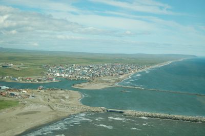
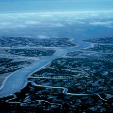
Norton Sound is a fjord in western Alaska that extends deep inland and connects numerous coastal communities. The body of water lies between the Seward Peninsula on the north and the Yukon River delta on the south, forming a major geographic feature of the region.

The fjord was named in 1778 by Captain James Cook, who gave it the name of Sir Fletcher Norton, a British parliamentary figure. This European naming marked an important moment in the external mapping of northwestern Alaskan waters, though Indigenous peoples had occupied and used these lands for far longer.

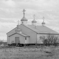
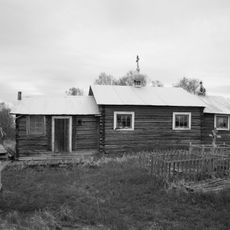
The waters form the center of life for Inupiat and Yup'ik communities, who have sustained themselves through fishing and hunting traditions here. You can see this deep connection to the sea reflected in how coastal villages are built and organized around access to the water.

The water is accessible to boats from May through October, offering maritime connections to Nome and other coastal settlements. Plan visits during these warmer months when the water is open and travel is most feasible for anyone reaching the area.

Five species of Pacific salmon inhabit these waters, and subsistence fishing for them provides more than half the food for mainland communities. This abundance of salmon makes the sound one of the most productive fishing grounds in the region for those who depend on it.

The community of curious travelers

AroundUs brings together thousands of curated places, local tips, and hidden gems, enriched daily by 60,000 contributors worldwide.

Start exploring
Location
Part of
Bering Sea
GPS coordinates
63.84917,-164.26889
Latest update
December 7, 2025 10:06
Around this place
Yukon Delta National Wildlife Refuge
United States of America

Yukon Delta National Wildlife Refuge

323.7 km
Monument to Semyon Dezhnev
Russian Federation

Monument to Semyon Dezhnev

352.2 km
Innoko National Wildlife Refuge
United States of America

Innoko National Wildlife Refuge

295.3 km
Trail Creek Caves
United States of America

Trail Creek Caves

219.9 km
Selawik National Wildlife Refuge
United States of America

Selawik National Wildlife Refuge

386.2 km
Innoko Wilderness
United States of America

Innoko Wilderness

308 km
Pilgrim Hot Springs
United States of America

Pilgrim Hot Springs

141.9 km
Cape Nome Mining District Discovery Sites
United States of America

Cape Nome Mining District Discovery Sites

95.8 km
Unalakleet River
United States of America

Unalakleet River

212.5 km
Old St. Joseph's Catholic Church
United States of America

Old St. Joseph's Catholic Church

91.1 km
Selawik River
United States of America

Selawik River

403.4 km
Nome River
United States of America

Nome River

101.2 km
Snake River
United States of America

Snake River

105 km
Chamisso Wilderness
United States of America

Chamisso Wilderness

288.2 km
Wales Site
United States of America

Wales Site

266.8 km
Kougarok River
United States of America

Kougarok River

181.2 km
Kuzitrin River
United States of America

Kuzitrin River

162.9 km
Christ Church Mission
United States of America

Christ Church Mission

243.3 km
Swanberg Dredge
United States of America

Swanberg Dredge

89.2 km
Solomon Roadhouse
United States of America

Solomon Roadhouse

79.5 km
Niukluk River
United States of America

Niukluk River

122 km
Iyatayet Site
United States of America

Iyatayet Site

147.6 km
St. Jacob's Church
United States of America

St. Jacob's Church

372.9 km
Kugruk River
United States of America

Kugruk River

239.9 km
St. Seraphim Chapel
United States of America

St. Seraphim Chapel

327.9 km
Shishmaref Inlet
United States of America

Shishmaref Inlet

279.9 km
Noxapaga River
United States of America

Noxapaga River

194.5 km
Bureau of Indian Affairs Unalakleet School
United States of America

Bureau of Indian Affairs Unalakleet School

170.9 km
Show the full map
Reviews
Share your experience

No review yet

Discussions
Start a discussion...

No discussion yet

« Norton Sound - Fjord in western Alaska, United States » is provided by Around Us (aroundus.com). Images and texts are derived from Wikimedia project under a Creative Commons license. You are allowed to copy, distribute, and modify copies of this page, under the conditions set by the license, as long as this note is clearly visible.

Discover hidden gems everywhere you go!

From secret cafés to breathtaking viewpoints, skip the crowded tourist spots and find places that match your style. Our app makes it easy with voice search, smart filtering, route optimization, and insider tips from travelers worldwide. Download now for the complete mobile experience.

Around Us App Screenshot

A unique approach to discovering new places

Le Figaro

All the places worth exploring

France Info

A tailor-made excursion in just a few clicks

20 Minutes

Around Us
Travel Guide & Maps
Download

Send to your phone

QR Code
1

Open the camera app on your mobile.

2

Point at the QR code with your camera. A notification will appear.

3

Tap the notification to open the link.