Enable Location

We need your location to show you interesting places around you

Discover nearby places

Find interesting locations and hidden gems around you

Precise directions

Get accurate directions and distances to places

Your location is never shared with other users. It's only used when you tap the location button.

Cape Nome Roadhouse

Log in to your account

Start exploring — it's free

Trusted by 63,735 travelers worldwide

Continue with Google
Continue with Apple
or

We will send you a code to connect

By continuing, you accept our Terms and Conditions and our Privacy Policy

Check your inbox

We've sent a pincode in your inbox. Please enter the code below.

Discussion Reviews 1 Photos
1.3k Popularity

Cape Nome Roadhouse, commercieel gebouw in Nome, Verenigde Staten van Amerika

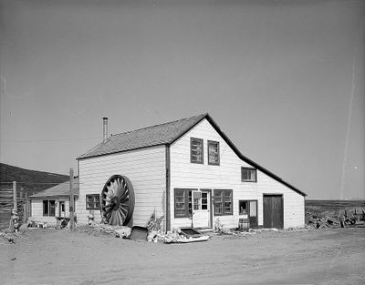
Cape Nome Roadhouse is a simple wooden building from 1901 located along a historic travel route near Nome. The structure features New England-style architecture with a saltbox roof and clapboard siding, originally built from logs and later expanded with wood framing.

The building was constructed in 1901 as a supply point for gold seekers during the regional gold rush. It was the only surviving structure from a historic supply route that played a key role in the legendary 1925 serum run to Nome.

The roadhouse served as a social gathering place where travelers and locals met to share meals and news. It reflects how such stopping points became centers of community life in remote Alaskan areas.

The roadhouse is located about 14 miles from Nome along a coastal road accessible by vehicle. Visitors should bring supplies and prepare for rugged weather conditions, as the site has limited services.

The building served as a communication base during World War II and later as an orphanage when illness swept the area. These shifting purposes show how important the roadhouse was in meeting changing community needs across decades.

The community of curious travelers

AroundUs brings together thousands of curated places, local tips, and hidden gems, enriched daily by 60,000 contributors worldwide.

Start exploring
Location
GPS coordinates
64.44360,-164.97400
Latest update
February 9, 2026 07:46
Around this place
Yukon Delta National Wildlife Refuge
United States of America

Yukon Delta National Wildlife Refuge

396.2 km
Whale Bone Alley
Russian Federation

Whale Bone Alley

361.6 km
Monument to Semyon Dezhnev
Russian Federation

Monument to Semyon Dezhnev

281.9 km
Innoko National Wildlife Refuge
United States of America

Innoko National Wildlife Refuge

344 km
Trail Creek Caves
United States of America

Trail Creek Caves

166.8 km
Selawik National Wildlife Refuge
United States of America

Selawik National Wildlife Refuge

358.2 km
Innoko Wilderness
United States of America

Innoko Wilderness

360.9 km
Pilgrim Hot Springs
United States of America

Pilgrim Hot Springs

72.3 km
Cape Nome Mining District Discovery Sites
United States of America

Cape Nome Mining District Discovery Sites

23.2 km
Unalakleet River
United States of America

Unalakleet River

249 km
Old St. Joseph's Catholic Church
United States of America

Old St. Joseph's Catholic Church

21.7 km
Selawik River
United States of America

Selawik River

381 km
Nome River
United States of America

Nome River

26.7 km
Snake River
United States of America

Snake River

31.8 km
Chamisso Wilderness
United States of America

Chamisso Wilderness

246.3 km
Wales Site
United States of America

Wales Site

195.3 km
Kougarok River
United States of America

Kougarok River

114.7 km
Squirrel River
United States of America

Squirrel River

361.1 km
Kuzitrin River
United States of America

Kuzitrin River

100.5 km
Christ Church Mission
United States of America

Christ Church Mission

309.2 km
Swanberg Dredge
United States of America

Swanberg Dredge

19.6 km
Solomon Roadhouse
United States of America

Solomon Roadhouse

28.7 km
Niukluk River
United States of America

Niukluk River

74.1 km
Iyatayet Site
United States of America

Iyatayet Site

166.3 km
Kugruk River
United States of America

Kugruk River

194.9 km
Shishmaref Inlet
United States of America

Shishmaref Inlet

207.6 km
Noxapaga River
United States of America

Noxapaga River

135 km
Bureau of Indian Affairs Unalakleet School
United States of America

Bureau of Indian Affairs Unalakleet School

213 km
Show the full map
Reviews
Share your experience

No review yet

Discussions
Start a discussion...

No discussion yet

« Cape Nome Roadhouse - commercieel gebouw in Nome, Verenigde Staten van Amerika » is provided by Around Us (aroundus.com). Images and texts are derived from Wikimedia project under a Creative Commons license. You are allowed to copy, distribute, and modify copies of this page, under the conditions set by the license, as long as this note is clearly visible.

Discover hidden gems everywhere you go!

From secret cafés to breathtaking viewpoints, skip the crowded tourist spots and find places that match your style. Our app makes it easy with voice search, smart filtering, route optimization, and insider tips from travelers worldwide. Download now for the complete mobile experience.

Around Us App Screenshot

A unique approach to discovering new places

Le Figaro

All the places worth exploring

France Info

A tailor-made excursion in just a few clicks

20 Minutes

Around Us
Travel Guide & Maps
Download

Send to your phone

QR Code
1

Open the camera app on your mobile.

2

Point at the QR code with your camera. A notification will appear.

3

Tap the notification to open the link.