Chest opened
+${chestReward.xp} XP
Explorer
NOUVEAU ×${chestReward.collectible.quantity}
tapez pour fermer
Chest locked

Open chests in the app

Around Us is built for your phone — chests unlock when you walk, explore and capture nearby places.

Enable Location

We need your location to show you interesting places around you

Discover nearby places

Find interesting locations and hidden gems around you

Precise directions

Get accurate directions and distances to places

Your location is never shared with other users. It's only used when you tap the location button.

Honey Lake

Log in to your account

Start exploring — it's free

Trusted by 72,891 travelers worldwide

Continue with Google
Continue with Apple
or

We will send you a code to connect

By continuing, you accept our Terms and Conditions and our Privacy Policy

Check your inbox

We've sent a pincode in your inbox. Please enter the code below.

Honey Lake
Discussion Reviews 1 Photos
18.5k Popularity

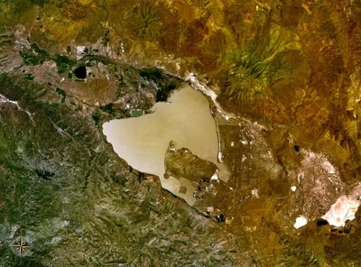
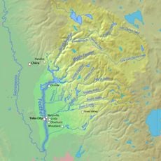
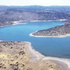
Honey Lake, Wetland lake in northeastern California, United States

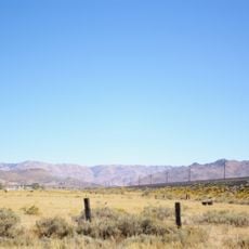
Honey Lake is a shallow body of water located in the high desert region of northeastern California. Water levels rise and fall throughout the year depending on rainfall and how much water evaporates.

Long ago during the Pleistocene, this lake was part of a much larger ancient water body called Lake Lahontan that covered a wide region. The lake shrank as climate conditions changed over time.

Native Paiute people made this lake their home for generations, depending on its waters and surrounding lands for food and daily survival. The place held deep meaning in their way of life.

The lake is easiest to reach from the town of Susanville by driving east and following local roads toward the water. This is a remote desert area, so it is wise to bring plenty of fuel and water before heading out.

The name comes from honeydew, a sticky liquid produced by aphids that once covered the plants around the lake in massive numbers. Early settlers noticed this unusual natural phenomenon and named the place accordingly.

The community of curious travelers

AroundUs brings together thousands of curated places, local tips, and hidden gems, enriched daily by 60,000 contributors worldwide.

Start exploring
Location
GPS coordinates
40.25000,-120.35000
Latest update
December 7, 2025 19:22
Around this place
Lake Almanor
United States of America

Lake Almanor

68.8 km
Plumas National Forest
United States of America

Plumas National Forest

39.5 km
Lassen National Forest
United States of America

Lassen National Forest

62.7 km
Western Pacific Railroad Museum
United States of America

Western Pacific Railroad Museum

50.8 km
Beckwourth Pass
United States of America

Beckwourth Pass

55 km
Plumas-Eureka State Park
United States of America

Plumas-Eureka State Park

62.3 km
Caribou Wilderness
United States of America

Caribou Wilderness

77.5 km
Bucks Lake Wilderness
United States of America

Bucks Lake Wilderness

77.7 km
1872 California-Nevada State Boundary Marker
United States of America

1872 California-Nevada State Boundary Marker

86.1 km
Crystal Peak
United States of America

Crystal Peak

80.2 km
Little Grass Valley Reservoir
United States of America

Little Grass Valley Reservoir

79.6 km
Antelope Dam
United States of America

Antelope Dam

23.1 km
United States of America

Bucks Lake

80.2 km
Reno Air Defense Sector
United States of America

Reno Air Defense Sector

77.7 km
Anaho Island National Wildlife Refuge
United States of America

Anaho Island National Wildlife Refuge

78.6 km
Canyon Dam
United States of America

Canyon Dam

63.5 km
Clio trestle
United States of America

Clio trestle

58.3 km
Hosselkus Limestone
United States of America

Hosselkus Limestone

37.9 km
Dodge Reservoir
United States of America

Dodge Reservoir

81.9 km
Mount Harkness Fire Lookout
United States of America

Mount Harkness Fire Lookout

83.2 km
Roop's Fort
United States of America

Roop's Fort

32 km
Sierra County Sheriff's Gallows
United States of America

Sierra County Sheriff's Gallows

87.2 km
Schroeder Mountain
United States of America

Schroeder Mountain

71 km
Horseshoe Lake Ranger Station
United States of America

Horseshoe Lake Ranger Station

86.8 km
Hospital Bridge
United States of America

Hospital Bridge

85.8 km
Standish Hall
United States of America

Standish Hall

14.2 km
Lassen County Court House
United States of America

Lassen County Court House

32.3 km
Kings Creek
United States of America

Kings Creek

86.9 km
Show the full map
Reviews
Share your experience

No review yet

Discussions
Start a discussion...

No discussion yet

« Honey Lake - Wetland lake in northeastern California, United States » is provided by Around Us (aroundus.com). Images and texts are derived from Wikimedia project under a Creative Commons license. You are allowed to copy, distribute, and modify copies of this page, under the conditions set by the license, as long as this note is clearly visible.

Discover hidden gems everywhere you go!

From secret cafés to breathtaking viewpoints, skip the crowded tourist spots and find places that match your style. Our app makes it easy with voice search, smart filtering, route optimization, and insider tips from travelers worldwide. Download now for the complete mobile experience.

Around Us App Screenshot

A unique approach to discovering new places

Le Figaro

All the places worth exploring

France Info

A tailor-made excursion in just a few clicks

20 Minutes

Around Us
Travel Guide & Maps
Download

Send to your phone

QR Code
1

Open the camera app on your mobile.

2

Point at the QR code with your camera. A notification will appear.

3

Tap the notification to open the link.