Isaac Lee Patterson Bridge

Log in to your account

AroundUs is a community-driven map of interesting places, built by curious explorers like you. It grows with every review, story, and photo you share.
Connect to save your favorite spots, contribute locations, and create personalized routes.
By continuing, you accept our Terms and Conditions and our Privacy Policy
Add to collection
Map
Suggest a change
Share

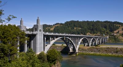
Isaac Lee Patterson Bridge, Concrete deck arch bridge in Gold Beach, United States.

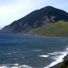
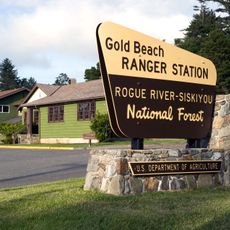
The Isaac Lee Patterson Bridge is a concrete arch bridge spanning the Rogue River at Gold Beach that connects the two riverbanks with seven deck arches. The structure extends over roughly 600 meters and carries U.S. Route 101 traffic across the river just before it flows into the Pacific Ocean.

The bridge was completed in 1932 and was the first application of the Freyssinet pre-tensioning method for arch structures in the United States. This innovative technique from Europe enabled a new approach to bridge construction that used longer spans more effectively.

The bridge displays Art Deco styling with decorative pylons at each end that reflect the simplified design language of 1930s engineering. Walking across it, you notice the refined details in the railings and supports that were characteristic of that era's approach to public structures.

You can cross the bridge anytime in your vehicle at no cost, with two lanes available for traffic in both directions. Pedestrians and cyclists should be cautious since the bridge is primarily designed for cars.

During construction, engineers built a concrete production facility on the north riverbank to manufacture materials on site rather than importing them. Reinforcing steel was transported over several kilometers from Port Orford, a remarkable feat of logistics for that era.

Location: Gold Beach

Inception: May 28, 1932

Official opening: May 28, 1932

Architectural style: Neoclassical architecture, Art Deco architecture

Made from material: concrete

GPS coordinates: 42.42720,-124.41300

Latest update: December 11, 2025 11:05

Photos
Around this place
Samuel H. Boardman State Scenic Corridor
United States of America

Samuel H. Boardman State Scenic Corridor

34.5 km
Oregon Islands National Wildlife Refuge
United States of America

Oregon Islands National Wildlife Refuge

19.8 km
Humbug Mountain State Park
United States of America

Humbug Mountain State Park

28.9 km
Thomas Creek Bridge
United States of America

Thomas Creek Bridge

29.4 km
Humbug Mountain
United States of America

Humbug Mountain

28 km
Wild Rogue Wilderness
United States of America

Wild Rogue Wilderness

36.2 km
Alfred A. Loeb State Park
United States of America

Alfred A. Loeb State Park

39.6 km
Cape Sebastian State Scenic Corridor
United States of America

Cape Sebastian State Scenic Corridor

10.6 km
Port Orford Heads State Park
United States of America

Port Orford Heads State Park

35.8 km
Arizona Beach State Recreation Site
United States of America

Arizona Beach State Recreation Site

20.9 km
Grassy Knob Wilderness
United States of America

Grassy Knob Wilderness

35.6 km
Lone Ranch Beach
United States of America

Lone Ranch Beach

37.1 km
Pistol River State Scenic Viewpoint
United States of America

Pistol River State Scenic Viewpoint

17 km
Paradise Point State Recreation Site
United States of America

Paradise Point State Recreation Site

38.1 km
Battle Rock Wayside Park

Battle Rock Wayside Park

35.7 km
Ophir Beach
United States of America

Ophir Beach

13.7 km
Gold Beach Ranger Station
United States of America

Gold Beach Ranger Station

2.9 km
Rogue River Museum & Gift shop
United States of America

Rogue River Museum & Gift shop

783 m
Secret Beach
United States of America

Secret Beach

26.1 km
Meyers Creek Beach Viewpoint
United States of America

Meyers Creek Beach Viewpoint

12.8 km
Whaleshead Beach
United States of America

Whaleshead Beach

32.7 km
Meyers Creek Pullout South
United States of America

Meyers Creek Pullout South

13.6 km
Battle Rock
United States of America

Battle Rock

35.3 km
Redfish Rocks Marine Reserve
United States of America

Redfish Rocks Marine Reserve

30.8 km
Arizona Beach
United States of America

Arizona Beach

20.9 km
Agate Beach
United States of America

Agate Beach

36.6 km
Natural Bridges Cove
United States of America

Natural Bridges Cove

26.7 km
Battle Rock Arch
United States of America

Battle Rock Arch

35.6 km
Show the full map
Reviews

Visited this place? Tap the stars to rate it and share your experience / photos with the community! Try now! You can cancel it anytime.

« Isaac Lee Patterson Bridge - Concrete deck arch bridge in Gold Beach, United States » is provided by Around Us (aroundus.com). Images and texts are derived from Wikimedia project under a Creative Commons license. You are allowed to copy, distribute, and modify copies of this page, under the conditions set by the license, as long as this note is clearly visible.

Discover hidden gems everywhere you go!

From secret cafés to breathtaking viewpoints, skip the crowded tourist spots and find places that match your style. Our app makes it easy with voice search, smart filtering, route optimization, and insider tips from travelers worldwide. Download now for the complete mobile experience.

Around Us App Screenshot

A unique approach to discovering new places

Le Figaro

All the places worth exploring

France Info

A tailor-made excursion in just a few clicks

20 Minutes