Enable Location

We need your location to show you interesting places around you

Discover nearby places

Find interesting locations and hidden gems around you

Precise directions

Get accurate directions and distances to places

Your location is never shared with other users. It's only used when you tap the location button.

Thomas Creek Bridge

Log in to your account

Start exploring — it's free

Trusted by 63,026 travelers worldwide

Continue with Google
Continue with Apple
or

We will send you a code to connect

By continuing, you accept our Terms and Conditions and our Privacy Policy

Check your inbox

We've sent a pincode in your inbox. Please enter the code below.

Thomas Creek Bridge
Discussion Reviews 1 Photos
4.3k Popularity

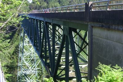
Thomas Creek Bridge, Deck truss bridge in Curry County, Oregon

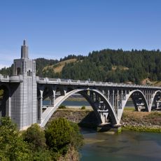
Thomas Creek Bridge is a steel structure that spans a deep valley along Oregon's coastal Highway 101. The bridge connects both sides of the valley using a steel truss framework made up of several large spans.

The bridge was designed and built by engineer Ivan D. Merchant in 1961 using a Warren deck truss system. It was a major project to carry the coastal highway across this deep valley.

The bridge is named after a creek that flows through the valley below, and its steel framework is visible from the highway as you drive along the coast.

You can view the bridge from Highway 101 and stop to photograph it from different angles. There are viewing points nearby where you can see the full structure and the canyon below from various perspectives.

The bridge rises approximately 345 feet (105 meters) above the creek and is one of the highest in Oregon. Its bold design made it possible to connect this previously inaccessible location.

The community of curious travelers

AroundUs brings together thousands of curated places, local tips, and hidden gems, enriched daily by 60,000 contributors worldwide.

Start exploring
Location
Inception
1961
Official opening
1961
GPS coordinates
42.16590,-124.35900
Latest update
December 11, 2025 11:03
Around this place
Jedediah Smith Redwoods State Park
United States of America

Jedediah Smith Redwoods State Park

47.8 km
St. George Reef Light
United States of America

St. George Reef Light

36.7 km
Lost Monarch
United States of America

Lost Monarch

47.6 km
Harris Beach State Park
United States of America

Harris Beach State Park

11.8 km
Samuel H. Boardman State Scenic Corridor
United States of America

Samuel H. Boardman State Scenic Corridor

5.1 km
Kalmiopsis Wilderness
United States of America

Kalmiopsis Wilderness

35.1 km
Oregon Islands National Wildlife Refuge
United States of America

Oregon Islands National Wildlife Refuge

10.1 km
Castle Rock National Wildlife Refuge
United States of America

Castle Rock National Wildlife Refuge

45.9 km
Tolowa Dunes State Park
United States of America

Tolowa Dunes State Park

35.8 km
Isaac Lee Patterson Bridge
United States of America

Isaac Lee Patterson Bridge

29.4 km
Alfred A. Loeb State Park
United States of America

Alfred A. Loeb State Park

15.2 km
Cape Sebastian State Scenic Corridor
United States of America

Cape Sebastian State Scenic Corridor

19.4 km
Lone Ranch Beach
United States of America

Lone Ranch Beach

7.6 km
Pistol River State Scenic Viewpoint
United States of America

Pistol River State Scenic Viewpoint

12.7 km
Camp Lincoln
United States of America

Camp Lincoln

42.7 km
Ophir Beach
United States of America

Ophir Beach

42.8 km
Gold Beach Ranger Station
United States of America

Gold Beach Ranger Station

26.7 km
Gasquet Ranger Station Historic District
United States of America

Gasquet Ranger Station Historic District

48.3 km
Crissey Field State Recreation Site

Crissey Field State Recreation Site

22 km
Pebble Beach
United States of America

Pebble Beach

45.9 km
Rogue River Museum & Gift shop
United States of America

Rogue River Museum & Gift shop

28.8 km
Secret Beach
United States of America

Secret Beach

3.4 km
Sporthaven Beach
United States of America

Sporthaven Beach

16 km
Meyers Creek Beach Viewpoint
United States of America

Meyers Creek Beach Viewpoint

16.9 km
Whaleshead Beach
United States of America

Whaleshead Beach

3.3 km
Redwood Theatre
United States of America

Redwood Theatre

14.2 km
Meyers Creek Pullout South
United States of America

Meyers Creek Pullout South

16.1 km
Natural Bridges Cove
United States of America

Natural Bridges Cove

2.7 km
Show the full map
Reviews
Share your experience

No review yet

Discussions
Start a discussion...

No discussion yet

« Thomas Creek Bridge - Deck truss bridge in Curry County, Oregon » is provided by Around Us (aroundus.com). Images and texts are derived from Wikimedia project under a Creative Commons license. You are allowed to copy, distribute, and modify copies of this page, under the conditions set by the license, as long as this note is clearly visible.

Discover hidden gems everywhere you go!

From secret cafés to breathtaking viewpoints, skip the crowded tourist spots and find places that match your style. Our app makes it easy with voice search, smart filtering, route optimization, and insider tips from travelers worldwide. Download now for the complete mobile experience.

Around Us App Screenshot

A unique approach to discovering new places

Le Figaro

All the places worth exploring

France Info

A tailor-made excursion in just a few clicks

20 Minutes

Around Us
Travel Guide & Maps
Download

Send to your phone

QR Code
1

Open the camera app on your mobile.

2

Point at the QR code with your camera. A notification will appear.

3

Tap the notification to open the link.