Enable Location

We need your location to show you interesting places around you

Discover nearby places

Find interesting locations and hidden gems around you

Precise directions

Get accurate directions and distances to places

Your location is never shared with other users. It's only used when you tap the location button.

Swift Reservoir

Log in to your account

Start exploring — it's free

Trusted by 62,365 travelers worldwide

Continue with Google
Continue with Apple
or

We will send you a code to connect

By continuing, you accept our Terms and Conditions and our Privacy Policy

Check your inbox

We've sent a pincode in your inbox. Please enter the code below.

Swift Reservoir

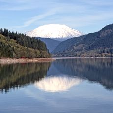
Swift Reservoir, lake of the United States of America

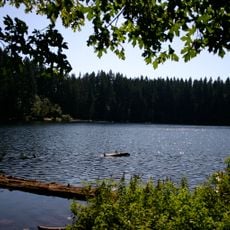
Swift Reservoir is a large body of water in Skamania County, Washington, created by damming the Lewis River. The water stretches between forested hills with natural shorelines, features a small island in its center, and sits at an elevation of about 1,000 feet above sea level.

The dam was completed in 1958 when the Swift Dam was built across the Lewis River to manage water flow. This construction was part of the region's water management strategy and permanently transformed the landscape from an open river valley into a recreation area.

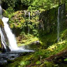
The reservoir serves as a gathering place for the local community and visitors seeking outdoor recreation. People come here to fish, paddle, and relax by the water, making it a space where nature and leisure activities blend into daily life.

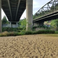
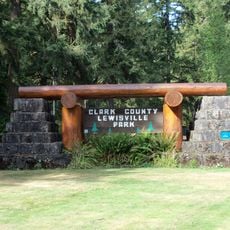
The site is easily accessible by Highway 503 with several parking areas and roads leading to campsites, boat ramps, and picnic areas. Bring water, food, and sun protection since there are no shops near the reservoir, and some parks operate only during warmer months.

The reservoir contains Sensi Island, a small island in the middle of the open water that draws visitors and provides a quiet place for exploration. Many find it remarkable because it stands out distinctly from the surrounding water and adds a natural focal point to the landscape.

The community of curious travelers

AroundUs brings together thousands of curated places, local tips, and hidden gems, enriched daily by 60,000 contributors worldwide.

Start exploring
Location
Elevation above the sea
308 m
GPS coordinates
46.06310,-122.19800
Latest update
February 9, 2026 08:23
Around this place
Mount St. Helens
United States of America

Mount St. Helens

14.3 km
Ape Canyon
United States of America

Ape Canyon

16.9 km
Gifford Pinchot National Forest
United States of America

Gifford Pinchot National Forest

36.9 km
Crater Glacier
United States of America

Crater Glacier

14.9 km
Battle Ground Lake State Park
United States of America

Battle Ground Lake State Park

36.7 km
Panther Creek Falls
United States of America

Panther Creek Falls

36 km
Indian Heaven Wilderness
United States of America

Indian Heaven Wilderness

32.4 km
Yale Lake
United States of America

Yale Lake

15.1 km
Table Mountain
United States of America

Table Mountain

44.5 km
Paradise Point State Park
United States of America

Paradise Point State Park

44.8 km
Lewisville Park
United States of America

Lewisville Park

38.1 km
Trapper Creek Wilderness
United States of America

Trapper Creek Wilderness

22.1 km
Cedar Creek Grist Mill
United States of America

Cedar Creek Grist Mill

32.9 km
Greenleaf Peak
United States of America

Greenleaf Peak

42.8 km
Lemei Rock
United States of America

Lemei Rock

34.2 km
Wind River Experimental Forest
United States of America

Wind River Experimental Forest

32.9 km
Yale Bridge
United States of America

Yale Bridge

17.6 km
Lelooska Museum
United States of America

Lelooska Museum

31.2 km
Wind River Arboretum
United States of America

Wind River Arboretum

35.8 km
Marble Mountain-Trout Creek Hill
United States of America

Marble Mountain-Trout Creek Hill

23.8 km
Amboy United Brethren Church
United States of America

Amboy United Brethren Church

25.9 km
Venersborg School
United States of America

Venersborg School

36.7 km
Battle Ground Cinema
United States of America

Battle Ground Cinema

42.3 km
Woodland Theatre
United States of America

Woodland Theatre

46.2 km
Yacolt Library Express
United States of America

Yacolt Library Express

27.2 km
Sister Rocks
United States of America

Sister Rocks

18.5 km
Battle Ground Community Library
United States of America

Battle Ground Community Library

40.8 km
Hoffstadt Creek Bridge
United States of America

Hoffstadt Creek Bridge

34.6 km
Show the full map
« Swift Reservoir - lake of the United States of America » is provided by Around Us (aroundus.com). Images and texts are derived from Wikimedia project under a Creative Commons license. You are allowed to copy, distribute, and modify copies of this page, under the conditions set by the license, as long as this note is clearly visible.

Discover hidden gems everywhere you go!

From secret cafés to breathtaking viewpoints, skip the crowded tourist spots and find places that match your style. Our app makes it easy with voice search, smart filtering, route optimization, and insider tips from travelers worldwide. Download now for the complete mobile experience.

Around Us App Screenshot

A unique approach to discovering new places

Le Figaro

All the places worth exploring

France Info

A tailor-made excursion in just a few clicks

20 Minutes

Around Us
Travel Guide & Maps
Download

Send to your phone

QR Code
1

Open the camera app on your mobile.

2

Point at the QR code with your camera. A notification will appear.

3

Tap the notification to open the link.