Chest opened
+${chestReward.xp} XP
Explorer
NOUVEAU ×${chestReward.collectible.quantity}
tapez pour fermer
Chest locked

Open chests in the app

Around Us is built for your phone — chests unlock when you walk, explore and capture nearby places.

Enable Location

We need your location to show you interesting places around you

Discover nearby places

Find interesting locations and hidden gems around you

Precise directions

Get accurate directions and distances to places

Your location is never shared with other users. It's only used when you tap the location button.

Log in to your account

Start exploring — it's free

Trusted by 72,927 travelers worldwide

Continue with Google
Continue with Apple
or

We will send you a code to connect

By continuing, you accept our Terms and Conditions and our Privacy Policy

Check your inbox

We've sent a pincode in your inbox. Please enter the code below.

Savage Island
Discussion Reviews Photo
1.2k Popularity

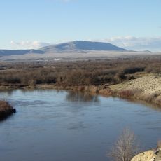
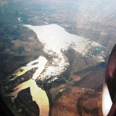
Savage Island, River island in Columbia River, Washington, US

Savage Island is a river island in the Columbia River that forms part of the Hanford Reach National Monument. The landscape features arid shrub steppe vegetation mixed with wetland areas along the riverbanks.

The island was acquired by the US Department of Energy in 1943 during Manhattan Project land acquisitions. This takeover resulted in changed management and eventually led to its protected status as part of the monument.

The Wanapum Native American tribe maintained settlements in the Savage Island region, utilizing the Columbia River's resources for their traditional activities.

Visitors should bring all necessary supplies as the island has no facilities or infrastructure. Seasonal water level changes affect access times, so planning ahead is important.

The island provides habitat for mule deer, coyotes, burrowing owls, and western diamondback rattlesnakes within its protected ecosystem. These animal populations thrive in the remote and carefully managed area.

The community of curious travelers

AroundUs brings together thousands of curated places, local tips, and hidden gems, enriched daily by 60,000 contributors worldwide.

Start exploring
Location
GPS coordinates
46.54740,-119.30200
Latest update
December 21, 2025 16:05
Around this place
Pacific Northwest National Laboratory
United States of America

Pacific Northwest National Laboratory

22.8 km
B Reactor
United States of America

B Reactor

28 km
Gold Coast Historic District
United States of America

Gold Coast Historic District

27.9 km
Ice Harbor Dam
United States of America

Ice Harbor Dam

46.4 km
Rattlesnake Mountain
United States of America

Rattlesnake Mountain

28.5 km
Cable Bridge
United States of America

Cable Bridge

39.7 km
Potholes Reservoir
United States of America

Potholes Reservoir

48.4 km
Priest Rapids Dam
United States of America

Priest Rapids Dam

47.6 km
Drumheller Channels National Natural Landmark
United States of America

Drumheller Channels National Natural Landmark

48.3 km
Blue Bridge
United States of America

Blue Bridge

38.1 km
Abraham Lincoln
United States of America

Abraham Lincoln

37.7 km
Columbia River Washington Temple
United States of America

Columbia River Washington Temple

35.8 km
Columbia National Wildlife Refuge
United States of America

Columbia National Wildlife Refuge

38.3 km
Sacajawea State Park
United States of America

Sacajawea State Park

43.5 km
Juniper Dunes Wilderness
United States of America

Juniper Dunes Wilderness

38.3 km
Bateman Island
United States of America

Bateman Island

34.2 km
Clover Island
United States of America

Clover Island

39.6 km
Interstate 182 Bridge
United States of America

Interstate 182 Bridge

31.9 km
Vernita Bridge
United States of America

Vernita Bridge

34.6 km
REACH Museum
United States of America

REACH Museum

35.3 km
Benton City – Kiona Bridge
United States of America

Benton City – Kiona Bridge

35.4 km
United States of America

Badger Mountain Centennial Preserve

34.8 km
Columbia River Exhibition of History, Science, and Technology
United States of America

Columbia River Exhibition of History, Science, and Technology

30.6 km
Clover Island Light
United States of America

Clover Island Light

39.6 km
Franklin County Courthouse
United States of America

Franklin County Courthouse

38 km
2800 Polar Way
United States of America

2800 Polar Way

23.6 km
USS Triton Submarine
United States of America

USS Triton Submarine

22.2 km
West Richland Golf Course
United States of America

West Richland Golf Course

27.2 km
Show the full map
Reviews
Share your experience

No review yet

Discussions
Start a discussion...

No discussion yet

« Savage Island - River island in Columbia River, Washington, US » is provided by Around Us (aroundus.com). Images and texts are derived from Wikimedia project under a Creative Commons license. You are allowed to copy, distribute, and modify copies of this page, under the conditions set by the license, as long as this note is clearly visible.

Discover hidden gems everywhere you go!

From secret cafés to breathtaking viewpoints, skip the crowded tourist spots and find places that match your style. Our app makes it easy with voice search, smart filtering, route optimization, and insider tips from travelers worldwide. Download now for the complete mobile experience.

Around Us App Screenshot

A unique approach to discovering new places

Le Figaro

All the places worth exploring

France Info

A tailor-made excursion in just a few clicks

20 Minutes

Around Us
Travel Guide & Maps
Download

Send to your phone

QR Code
1

Open the camera app on your mobile.

2

Point at the QR code with your camera. A notification will appear.

3

Tap the notification to open the link.