Chest opened
+${chestReward.xp} XP
Explorer
NOUVEAU ×${chestReward.collectible.quantity}
tapez pour fermer
Chest locked

Open chests in the app

Around Us is built for your phone — chests unlock when you walk, explore and capture nearby places.

Enable Location

We need your location to show you interesting places around you

Discover nearby places

Find interesting locations and hidden gems around you

Precise directions

Get accurate directions and distances to places

Your location is never shared with other users. It's only used when you tap the location button.

Log in to your account

Start exploring — it's free

Trusted by 72,878 travelers worldwide

Continue with Google
Continue with Apple
or

We will send you a code to connect

By continuing, you accept our Terms and Conditions and our Privacy Policy

Check your inbox

We've sent a pincode in your inbox. Please enter the code below.

LORAN-C transmitter Saint Paul
Discussion Reviews Photo
1.6k Popularity

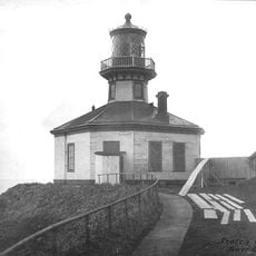
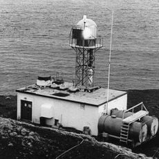
LORAN-C transmitter Saint Paul, Radio navigation transmitter in Saint Paul, Alaska.

The LORAN-C transmitter on Saint Paul was a radio navigation facility that broadcast signals across the northern Pacific. The installation used a tall mast antenna system to send positioning information to vessels and aircraft across vast distances.

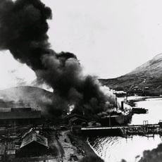
The facility was established as the master station for the North Pacific LORAN-C chain and played a key role in maritime navigation throughout the 20th century. Its importance declined as satellite navigation systems became the standard for determining vessel positions.

The station served as a vital navigation reference for vessels and aircraft crossing the northern Pacific. It represented an essential tool that mariners and pilots depended on for safe passage through one of the world's most challenging maritime regions.

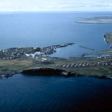
The station sits on the remote Saint Paul Island, which limits general public access to the facility. Visitors interested in viewing the site should plan accordingly, as severe weather and limited transportation options create significant practical challenges.

The station's placement on a tiny island in the middle of the northern Pacific made it a remarkable technical achievement for its era. Its ability to function reliably in such harsh conditions helped countless mariners navigate safely in a region where navigation errors could be fatal.

The community of curious travelers

AroundUs brings together thousands of curated places, local tips, and hidden gems, enriched daily by 60,000 contributors worldwide.

Start exploring
Location
GPS coordinates
57.15330,-170.25200
Latest update
December 14, 2025 14:26
Around this place
Mount Cleveland
United States of America

Mount Cleveland

482.5 km
Mount Shishaldin
United States of America

Mount Shishaldin

473.5 km
Mount Okmok
United States of America

Mount Okmok

438.5 km
Dutch Harbor Naval Operating Base and Fort Mears, U.S. Army
United States of America

Dutch Harbor Naval Operating Base and Fort Mears, U.S. Army

431.1 km
Mount Akutan
United States of America

Mount Akutan

429.8 km
Makushin Volcano
United States of America

Makushin Volcano

419.3 km
Mount Vsevidof
United States of America

Mount Vsevidof

459.1 km
SS Northwestern
United States of America

SS Northwestern

435.3 km
Izembek National Wildlife Refuge
United States of America

Izembek National Wildlife Refuge

510.2 km
Amak Volcano
United States of America

Amak Volcano

479.3 km
Cape Field at Fort Glenn
United States of America

Cape Field at Fort Glenn

446.2 km
Mount Carlisle
United States of America

Mount Carlisle

474.6 km
Fisher Caldera
United States of America

Fisher Caldera

458.8 km
Sts. Peter and Paul Church
United States of America

Sts. Peter and Paul Church

4 km
Cape Sarichef Light
United States of America

Cape Sarichef Light

437.3 km
Cold Bay Volcano
United States of America

Cold Bay Volcano

515.3 km
Bogoslof Wilderness
United States of America

Bogoslof Wilderness

384.3 km
Seal Island Historic District
United States of America

Seal Island Historic District

30.2 km
Mount Gilbert
United States of America

Mount Gilbert

432.6 km
Anangula Archeological District
United States of America

Anangula Archeological District

470.1 km
Chaluka Site
United States of America

Chaluka Site

478.2 km
St. Nicholas Church
United States of America

St. Nicholas Church

477.4 km
Sitka Spruce Park
United States of America

Sitka Spruce Park

432.1 km
Mount Roundtop
United States of America

Mount Roundtop

490.2 km
Pyramid Peak
United States of America

Pyramid Peak

436.3 km
Dekanat Unalaska
United States of America

Dekanat Unalaska

433.4 km
Scotch Cap Light
United States of America

Scotch Cap Light

461.5 km
Scotch Cap Light
United States of America

Scotch Cap Light

461.5 km
Show the full map
Reviews
Share your experience

No review yet

Discussions
Start a discussion...

No discussion yet

« LORAN-C transmitter Saint Paul - Radio navigation transmitter in Saint Paul, Alaska » is provided by Around Us (aroundus.com). Images and texts are derived from Wikimedia project under a Creative Commons license. You are allowed to copy, distribute, and modify copies of this page, under the conditions set by the license, as long as this note is clearly visible.

Discover hidden gems everywhere you go!

From secret cafés to breathtaking viewpoints, skip the crowded tourist spots and find places that match your style. Our app makes it easy with voice search, smart filtering, route optimization, and insider tips from travelers worldwide. Download now for the complete mobile experience.

Around Us App Screenshot

A unique approach to discovering new places

Le Figaro

All the places worth exploring

France Info

A tailor-made excursion in just a few clicks

20 Minutes

Around Us
Travel Guide & Maps
Download

Send to your phone

QR Code
1

Open the camera app on your mobile.

2

Point at the QR code with your camera. A notification will appear.

3

Tap the notification to open the link.