
Arrigetch Peaks, glacier in United States

Kobuk Valley National Park
216.3 km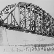
Mears Memorial Bridge
393.6 km
E. L. Patton Yukon River Bridge
263 km
Gates of the Arctic Wilderness
89.7 km
Nowitna River
374.4 km
Yukon Flats National Wildlife Refuge
378.7 km
Mount Igikpak
31.9 km
Arrigetch Peaks
1.6 km
White Mountains National Recreation Area
363 km
Noatak Wilderness
235.9 km
Kanuti National Wildlife Refuge
152.8 km
John River
92.2 km
Koyukuk National Wildlife Refuge
228.4 km
Selawik National Wildlife Refuge
234.5 km
Nowitna National Wildlife Refuge
306.9 km
North Fork Koyukuk River
144 km
Selawik River
208.1 km
Chamisso Wilderness
358.7 km
Gallagher Flint Station Archeological Site
312.9 km
Onion Portage Archeological District
179.2 km
Itkillik River
253.1 km
Squirrel River
295.8 km
Walker Lake
33.5 km
Kanuti River
177.4 km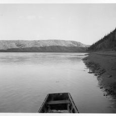
Rampart Canyon
271.6 km
Salmon River
236.8 km
Dall River
246.2 km
Tolovana River
344.2 kmReviews
Visited this place? Tap the stars to rate it and share your experience / photos with the community! Try now! You can cancel it anytime.
Discover hidden gems everywhere you go!
From secret cafés to breathtaking viewpoints, skip the crowded tourist spots and find places that match your style. Our app makes it easy with voice search, smart filtering, route optimization, and insider tips from travelers worldwide. Download now for the complete mobile experience.

A unique approach to discovering new places❞
— Le Figaro
All the places worth exploring❞
— France Info
A tailor-made excursion in just a few clicks❞
— 20 Minutes