Chest opened
+${chestReward.xp} XP
Explorer
NOUVEAU ×${chestReward.collectible.quantity}
tapez pour fermer
Chest locked

Open chests in the app

Around Us is built for your phone — chests unlock when you walk, explore and capture nearby places.

Enable Location

We need your location to show you interesting places around you

Discover nearby places

Find interesting locations and hidden gems around you

Precise directions

Get accurate directions and distances to places

Your location is never shared with other users. It's only used when you tap the location button.

Log in to your account

Start exploring — it's free

Trusted by 72,984 travelers worldwide

Continue with Google
Continue with Apple
or

We will send you a code to connect

By continuing, you accept our Terms and Conditions and our Privacy Policy

Check your inbox

We've sent a pincode in your inbox. Please enter the code below.

Oliktok Long Range Radar Site
Discussion Reviews Photo
3.9k Popularity

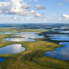
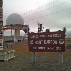
Oliktok Long Range Radar Site, Military radar installation in North Slope, Alaska.

Oliktok Long Range Radar Site is a military installation on Alaska's North Slope that sits atop the Arctic tundra. The facility includes a gravel runway and modern surveillance equipment designed to monitor the region's airspace.

The site was built in 1957 as an early warning station and originally operated as part of the DEW Line system. It was later integrated into the North Warning System in 1995.

The installation represents Cold War military engineering, demonstrating the technological capabilities developed for Arctic defense during the twentieth century conflicts.

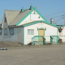
The site is extremely remote and requires military authorization to access. Only official military aircraft and authorized personnel are permitted to land on the runway or enter the facility.

The Department of Defense utilizes this northernmost radar station for continuous monitoring of Arctic airspace, integrating modern AN/FPS-117 surveillance technology.

The community of curious travelers

AroundUs brings together thousands of curated places, local tips, and hidden gems, enriched daily by 60,000 contributors worldwide.

Start exploring
Location
GPS coordinates
70.49830,-149.88900
Latest update
December 11, 2025 18:03
Around this place
Arctic National Wildlife Refuge
United States of America

Arctic National Wildlife Refuge

314.7 km
Kobuk Valley National Park
United States of America

Kobuk Valley National Park

496.9 km
Ivvavik National Park
Canada

Ivvavik National Park

408.6 km
Vuntut National Park
Canada

Vuntut National Park

455.3 km
Mount Isto
United States of America

Mount Isto

274.2 km
Rogers-Post Site
United States of America

Rogers-Post Site

271.6 km
Point Barrow Long Range Radar Site
United States of America

Point Barrow Long Range Radar Site

262.2 km
Gates of the Arctic Wilderness
United States of America

Gates of the Arctic Wilderness

294.7 km
Yukon Flats National Wildlife Refuge
United States of America

Yukon Flats National Wildlife Refuge

490 km
Mount Igikpak
United States of America

Mount Igikpak

398.6 km
Arrigetch Peaks
United States of America

Arrigetch Peaks

383 km
Point Barrow Refuge Station
United States of America

Point Barrow Refuge Station

265.9 km
Leffingwell Camp Site
United States of America

Leffingwell Camp Site

147.8 km
Noatak Wilderness
United States of America

Noatak Wilderness

466.3 km
Kanuti National Wildlife Refuge
United States of America

Kanuti National Wildlife Refuge

461.2 km
John River
United States of America

John River

350.3 km
Birnirk Site
United States of America

Birnirk Site

264.7 km
North Fork Koyukuk River
United States of America

North Fork Koyukuk River

340.3 km
Herschel Island-Qikiqtaruk Territorial Park
Canada

Herschel Island-Qikiqtaruk Territorial Park

424 km
Gallagher Flint Station Archeological Site
United States of America

Gallagher Flint Station Archeological Site

133.9 km
Onion Portage Archeological District
United States of America

Onion Portage Archeological District

507 km
Itkillik River
United States of America

Itkillik River

141.6 km
Walker Lake
United States of America

Walker Lake

416 km
Iñupiat Heritage Center
United States of America

Iñupiat Heritage Center

265.3 km
Kanuti River
United States of America

Kanuti River

480.4 km
Peters Glacier (Brooks Range)
United States of America

Peters Glacier (Brooks Range)

232.3 km
Utqiaġvik Church Manse
United States of America

Utqiaġvik Church Manse

266 km
Dall River
United States of America

Dall River

477.6 km
Show the full map
Reviews
Share your experience

No review yet

Discussions
Start a discussion...

No discussion yet

« Oliktok Long Range Radar Site - Military radar installation in North Slope, Alaska » is provided by Around Us (aroundus.com). Images and texts are derived from Wikimedia project under a Creative Commons license. You are allowed to copy, distribute, and modify copies of this page, under the conditions set by the license, as long as this note is clearly visible.

Discover hidden gems everywhere you go!

From secret cafés to breathtaking viewpoints, skip the crowded tourist spots and find places that match your style. Our app makes it easy with voice search, smart filtering, route optimization, and insider tips from travelers worldwide. Download now for the complete mobile experience.

Around Us App Screenshot

A unique approach to discovering new places

Le Figaro

All the places worth exploring

France Info

A tailor-made excursion in just a few clicks

20 Minutes

Around Us
Travel Guide & Maps
Download

Send to your phone

QR Code
1

Open the camera app on your mobile.

2

Point at the QR code with your camera. A notification will appear.

3

Tap the notification to open the link.