Enable Location

We need your location to show you interesting places around you

Discover nearby places

Find interesting locations and hidden gems around you

Precise directions

Get accurate directions and distances to places

Your location is never shared with other users. It's only used when you tap the location button.

Point Barrow Refuge Station

Log in to your account

Start exploring — it's free

Trusted by 62,298 travelers worldwide

Continue with Google
Continue with Apple
or

We will send you a code to connect

By continuing, you accept our Terms and Conditions and our Privacy Policy

Check your inbox

We've sent a pincode in your inbox. Please enter the code below.

Point Barrow Refuge Station

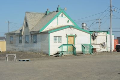
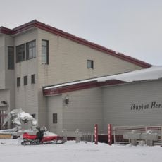
The Point Barrow Refuge Station is a lifeboat station in Utqiagvik, on Alaska's northern coast. Built in 1889 from wood with a simple rectangular shape and steep roof, it was originally intended as a refuge for whaling ships in the icy Arctic waters nearby.

Built in 1889 as a rescue station for whaling ships, it served this purpose until around 1896. Later it was converted to a trading business and then a cafe, but remains an important historic landmark since its listing on the National Register of Historic Places in 1980.

The station is tied to the region's long maritime history, where whaling and trade were central to people's lives. The building reflects the practical demands that came from working with the sea in one of Earth's harshest environments.

The site is very remote and requires preparation for extreme cold and solitary conditions. Visitors should bring warm clothing and realistic expectations about infrastructure, as there are only limited facilities in the immediate area.

The building is the oldest wood-frame structure in Utqiagvik, dating from a time when the Arctic was barely explored. Its simple construction and additions, including a shed that later became Brower's Cafe, show the practical adaptation to harsh life in an extreme environment.

The community of curious travelers

AroundUs brings together thousands of curated places, local tips, and hidden gems, enriched daily by 60,000 contributors worldwide.

Start exploring
Location
Inception
1889
GPS coordinates
71.29780,-156.77300
Latest update
February 9, 2026 08:22
Around this place
Arctic National Wildlife Refuge
United States of America

Arctic National Wildlife Refuge

577.3 km
Kobuk Valley National Park
United States of America

Kobuk Valley National Park

428.5 km
Mount Isto
United States of America

Mount Isto

539.4 km
Rogers-Post Site
United States of America

Rogers-Post Site

18.7 km
Point Barrow Long Range Radar Site
United States of America

Point Barrow Long Range Radar Site

5.9 km
Gates of the Arctic Wilderness
United States of America

Gates of the Arctic Wilderness

383.5 km
United States of America

Ipiutak Site

506 km
Mount Igikpak
United States of America

Mount Igikpak

438.2 km
Arrigetch Peaks
United States of America

Arrigetch Peaks

443.4 km
Leffingwell Camp Site
United States of America

Leffingwell Camp Site

412 km
Noatak Wilderness
United States of America

Noatak Wilderness

375.5 km
Kanuti National Wildlife Refuge
United States of America

Kanuti National Wildlife Refuge

578 km
John River
United States of America

John River

466.3 km
Selawik National Wildlife Refuge
United States of America

Selawik National Wildlife Refuge

533.4 km
Birnirk Site
United States of America

Birnirk Site

1.8 km
North Fork Koyukuk River
United States of America

North Fork Koyukuk River

485.7 km
Selawik River
United States of America

Selawik River

537.7 km
Chamisso Wilderness
United States of America

Chamisso Wilderness

599.9 km
Gallagher Flint Station Archeological Site
United States of America

Gallagher Flint Station Archeological Site

370.6 km
Onion Portage Archeological District
United States of America

Onion Portage Archeological District

471.5 km
Itkillik River
United States of America

Itkillik River

327 km
Squirrel River
United States of America

Squirrel River

478.7 km
Walker Lake
United States of America

Walker Lake

473.9 km
Iñupiat Heritage Center
United States of America

Iñupiat Heritage Center

719 m
Kanuti River
United States of America

Kanuti River

602.3 km
Peters Glacier (Brooks Range)
United States of America

Peters Glacier (Brooks Range)

496.1 km
Utqiaġvik Church Manse
United States of America

Utqiaġvik Church Manse

610 m
Salmon River
United States of America

Salmon River

437.4 km
Show the full map
« Point Barrow Refuge Station » is provided by Around Us (aroundus.com). Images and texts are derived from Wikimedia project under a Creative Commons license. You are allowed to copy, distribute, and modify copies of this page, under the conditions set by the license, as long as this note is clearly visible.

Discover hidden gems everywhere you go!

From secret cafés to breathtaking viewpoints, skip the crowded tourist spots and find places that match your style. Our app makes it easy with voice search, smart filtering, route optimization, and insider tips from travelers worldwide. Download now for the complete mobile experience.

Around Us App Screenshot

A unique approach to discovering new places

Le Figaro

All the places worth exploring

France Info

A tailor-made excursion in just a few clicks

20 Minutes

Around Us
Travel Guide & Maps
Download

Send to your phone

QR Code
1

Open the camera app on your mobile.

2

Point at the QR code with your camera. A notification will appear.

3

Tap the notification to open the link.