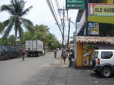
Puerto Viejo de Talamanca, Caribbean coastal town in Limón Province, Costa Rica
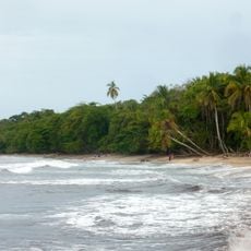
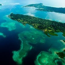
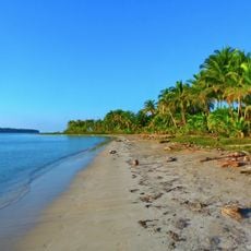
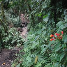
Puerto Viejo de Talamanca stretches along the Caribbean coastline at an elevation of 4 meters, surrounded by tropical vegetation and white sand beaches.
The settlement evolved from an English-named Old Harbour into Puerto Viejo following Costa Rica's nationwide Spanish language standardization during the colonial period.
The local population combines Costa Ricans of Jamaican descent, indigenous Bribri communities, European settlers, and native Costa Ricans, creating multilingual neighborhoods.
Travelers can reach Puerto Viejo de Talamanca by taking a four-hour drive from San José on Highway 36, with regular bus services operating between both cities.
The Salsa Brava wave formation near the town creates one of Costa Rica's largest surf breaks, drawing water sports enthusiasts from across the globe.
Location: Cahuita
Elevation above the sea: 4 m
GPS coordinates: 9.65639,-82.75420
Latest update: March 3, 2025 23:03
Costa Rica spans 19,700 square miles (51,100 square kilometers) between the Pacific Ocean and Caribbean Sea, offering photographers a concentration of varied landscapes within a compact area. The country maintains over 30 national parks and protected areas, including Arenal Volcano, whose near-perfect cone rises 5,479 feet (1,670 meters) above surrounding rainforest, and Monteverde Cloud Forest, where mist drifts through canopy vegetation supporting rare species such as the resplendent quetzal. Rio Celeste flows through Tenorio Volcano National Park, displaying its characteristic turquoise color from volcanic minerals, while Tabacon Hot Springs delivers naturally heated water from underground sources. Coastal regions present diverse subjects, from the beaches of Manuel Antonio National Park, where white-faced capuchin monkeys move through trees, to Cahuita National Park on the Caribbean coast with its coral reefs. The Nicoya Peninsula and Papagayo Peninsula provide access to Tamarindo Beach and Santa Teresa Beach, while the southern zone includes Marino Ballena National Park, named for its whale-shaped sandbar visible at low tide. Tortuga Island, off the coast of Puntarenas, serves as a day-trip destination. Inland, San Jose Central Market documents daily commerce, the National Theater displays neoclassical architecture from 1897, and Guayabo National Monument preserves pre-Columbian ruins. Cerro Chirripó rises to 12,533 feet (3,820 meters) as the country's highest point, offering views of both oceans in clear conditions.
Stone spheres of Costa Rica
114.9 km
Volcan Baru
97.2 km
Cerro Chirripó
82.9 km
Turrialba
117.8 km
Guayabo National Monument
108.7 km
La Amistad International Park
34.4 km
Cerro de la Muerte
110.6 km
Volcán Barú National Park
94.4 km
Cahuita National Park
11.2 km
Bastimentos Island National Marine Park
78.2 km
Chirripó National Park
82.1 km
Talamanca Reserve
34.4 km
Barriles
95.5 km
Tapantí National Park
115.4 km
The Ara Project
8.3 km
Barbilla National Park
79.7 km
Las Mercedes
110.3 km
Cerro Ventisqueros
85.4 km
Volio Waterfall
12.8 km
Río Parismina
95.6 km
Starfish Beach
54.8 km
Puerto Limón Lighthouse
47.1 km
Lucero Golf Country Club
111.4 km
Talamanca Range-La Amistad Reserves
34.4 km
The Lost Waterfalls
95.6 km
Sendero Los Quetzales
93.6 km
Macho de Monte Cascadas
109.3 km
Gobernación de Bocas del Toro
66.4 kmReviews
Visited this place? Tap the stars to rate it and share your experience / photos with the community! Try now! You can cancel it anytime.
Discover hidden gems everywhere you go!
From secret cafés to breathtaking viewpoints, skip the crowded tourist spots and find places that match your style. Our app makes it easy with voice search, smart filtering, route optimization, and insider tips from travelers worldwide. Download now for the complete mobile experience.
A unique approach to discovering new places❞
— Le Figaro
All the places worth exploring❞
— France Info
A tailor-made excursion in just a few clicks❞
— 20 Minutes