
São Gabriel da Cachoeira, human settlement in Brazil
Location: São Gabriel da Cachoeira
Elevation above the sea: 74 m
GPS coordinates: -0.11810,-67.08527
Latest update: April 30, 2025 06:42

Pico da Neblina
157.5 km
Amacayacu National Park
510.3 km
Cerro Autana
555.1 km
The Hub on Causeway
521.8 km
Piedra del Cocuy
153.8 km
Pico da Neblina National Park
136 km
Pico 31 de Março
158 km
Jaú National Park
547.2 km
Serranía La Neblina National Park
166.3 km
Piedra del Cocuy Natural Monument
153.8 km
Parima-Tapirapecó National Park
426.3 km
Yapacana National Park
424.5 km
Duida-Marahuaca National Park
458.7 km
Mamirauá Sustainable Development Reserve
285.1 km
Cachoeira do El Dorado
431.3 km
Cerro Duida
423.6 km
Morro dos Seis Lagos Biological Reserve
65.4 km
Central Amazon Ecological Corridor
369.4 km
Serra do Aracá State Park
453.9 km
Forte de São José de Marabitanas
134.6 km
Tefé National Forest
444.4 km
Cué-cué/Marabitanas Indigenous Territory
109.2 km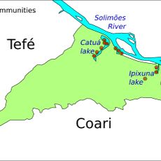
Catuá-Ipixuna Extractive Reserve
527.6 km
Auatí-Paraná Extractive Reserve
256.4 km
Parú-Euaja Massif Natural Monument
536.9 km
Cerros Vinilla y Aratitiyope Natural Monument
310.8 km
Monumento Natural Cerro Autana
555.1 km
Sierra Unturan Natural Monument
278.2 kmReviews
Visited this place? Tap the stars to rate it and share your experience / photos with the community! Try now! You can cancel it anytime.
Discover hidden gems everywhere you go!
From secret cafés to breathtaking viewpoints, skip the crowded tourist spots and find places that match your style. Our app makes it easy with voice search, smart filtering, route optimization, and insider tips from travelers worldwide. Download now for the complete mobile experience.

A unique approach to discovering new places❞
— Le Figaro
All the places worth exploring❞
— France Info
A tailor-made excursion in just a few clicks❞
— 20 Minutes