Chest opened
+${chestReward.xp} XP
Explorer
NOUVEAU ×${chestReward.collectible.quantity}
tapez pour fermer
Chest locked

Open chests in the app

Around Us is built for your phone — chests unlock when you walk, explore and capture nearby places.

Enable Location

We need your location to show you interesting places around you

Discover nearby places

Find interesting locations and hidden gems around you

Precise directions

Get accurate directions and distances to places

Your location is never shared with other users. It's only used when you tap the location button.

Silver Star Mountain

Log in to your account

Start exploring — it's free

Trusted by 72,893 travelers worldwide

Continue with Google
Continue with Apple
or

We will send you a code to connect

By continuing, you accept our Terms and Conditions and our Privacy Policy

Check your inbox

We've sent a pincode in your inbox. Please enter the code below.

Silver Star Mountain
Discussion Reviews 1 Photos
8.9k Popularity

Silver Star Mountain, Mountain peak in Skamania County, Washington, United States

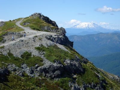
Silver Star Mountain is a prominent peak in the North Cascades that rises to about 4,390 feet with steep rocky slopes and alpine meadows. The distinctive summit structure is visible from many directions and offers multiple climbing routes of varying difficulty.

The western summit was first reached in 1952 by climber Fred Beckey and his team via the northeast approach from Silver Star Glacier. This ascent opened the peak to the climbing community and established routes that mountaineers still use today.

The mountain holds significance in the Pacific Northwest climbing community as part of the Washington Top 100 Peaks list and Washington 2000-ft Prominence Peaks.

The peak can be reached from the North Cascades Highway with two main trail options for different skill levels. Visitors should come prepared for alpine conditions and rocky terrain that require careful footing and proper gear.

The peak contains one of the largest glaciers on the eastern side of the Cascades, which creates distinct climbing challenges through different seasons. This frozen landscape attracts mountaineers seeking technical routes beyond standard hiking trails.

The community of curious travelers

AroundUs brings together thousands of curated places, local tips, and hidden gems, enriched daily by 60,000 contributors worldwide.

Start exploring
Location
GPS coordinates
45.74770,-122.23900
Latest update
December 10, 2025 15:59
Around this place
Multnomah Falls
United States of America

Multnomah Falls

21.4 km
Vista House
United States of America

Vista House

23.1 km
Beacon Rock State Park
United States of America

Beacon Rock State Park

19.8 km
Rooster Rock State Park
United States of America

Rooster Rock State Park

22.6 km
Oneonta Gorge
United States of America

Oneonta Gorge

21.7 km
Horsetail Falls
United States of America

Horsetail Falls

22.1 km
Battle Ground Lake State Park
United States of America

Battle Ground Lake State Park

20.8 km
Bridal Veil Falls
United States of America

Bridal Veil Falls

21.9 km
Wahkeena Falls
United States of America

Wahkeena Falls

21.1 km
Fairy Falls
United States of America

Fairy Falls

21.7 km
Steigerwald Lake National Wildlife Refuge
United States of America

Steigerwald Lake National Wildlife Refuge

20.9 km
Ainsworth State Park
United States of America

Ainsworth State Park

22.3 km
Table Mountain
United States of America

Table Mountain

20.8 km
Franz Lake National Wildlife Refuge
United States of America

Franz Lake National Wildlife Refuge

20.2 km
Greenleaf Peak
United States of America

Greenleaf Peak

21.5 km
Benson State Recreation Area
United States of America

Benson State Recreation Area

20.8 km
Wind River Experimental Forest
United States of America

Wind River Experimental Forest

21.1 km
Coopey Falls
United States of America

Coopey Falls

21.4 km
Farrell Building
United States of America

Farrell Building

22 km
John Roffler House
United States of America

John Roffler House

21.7 km
Pittock House
United States of America

Pittock House

20.3 km
Venersborg School
United States of America

Venersborg School

14.6 km
Beacon Rock
United States of America

Beacon Rock

21.6 km
Multnomah Falls Lodge and Footpath
United States of America

Multnomah Falls Lodge and Footpath

21.4 km
Yacolt Library Express
United States of America

Yacolt Library Express

18.6 km
Horsetail Falls Developed Area Masonry Walls and Kiosk
United States of America

Horsetail Falls Developed Area Masonry Walls and Kiosk

22 km
Pillars of Hercules
United States of America

Pillars of Hercules

22.1 km
Camas Public Library
United States of America

Camas Public Library

21.9 km
Show the full map
Reviews
Share your experience

No review yet

Discussions
Start a discussion...

No discussion yet

« Silver Star Mountain - Mountain peak in Skamania County, Washington, United States » is provided by Around Us (aroundus.com). Images and texts are derived from Wikimedia project under a Creative Commons license. You are allowed to copy, distribute, and modify copies of this page, under the conditions set by the license, as long as this note is clearly visible.

Discover hidden gems everywhere you go!

From secret cafés to breathtaking viewpoints, skip the crowded tourist spots and find places that match your style. Our app makes it easy with voice search, smart filtering, route optimization, and insider tips from travelers worldwide. Download now for the complete mobile experience.

Around Us App Screenshot

A unique approach to discovering new places

Le Figaro

All the places worth exploring

France Info

A tailor-made excursion in just a few clicks

20 Minutes

Around Us
Travel Guide & Maps
Download

Send to your phone

QR Code
1

Open the camera app on your mobile.

2

Point at the QR code with your camera. A notification will appear.

3

Tap the notification to open the link.