Chest opened
+${chestReward.xp} XP
Explorer
NOUVEAU ×${chestReward.collectible.quantity}
tapez pour fermer
Chest locked

Open chests in the app

Around Us is built for your phone — chests unlock when you walk, explore and capture nearby places.

Enable Location

We need your location to show you interesting places around you

Discover nearby places

Find interesting locations and hidden gems around you

Precise directions

Get accurate directions and distances to places

Your location is never shared with other users. It's only used when you tap the location button.

Lake Abert

Log in to your account

Start exploring — it's free

Trusted by 72,885 travelers worldwide

Continue with Google
Continue with Apple
or

We will send you a code to connect

By continuing, you accept our Terms and Conditions and our Privacy Policy

Check your inbox

We've sent a pincode in your inbox. Please enter the code below.

Lake Abert
Discussion Reviews 1 Photos
11k Popularity

Lake Abert, Saline lake in Lake County, Oregon.

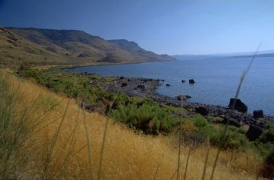
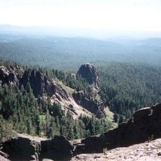
Lake Abert is a saline lake in Lake County, Oregon, surrounded by dry and sparse terrain that stretches across a significant expanse. The water contains high concentrations of minerals that make it unsuitable for human consumption but allow specialized life forms to thrive.

The lake was named in 1843 during an exploration mission and takes its name from a military officer whose work shaped knowledge of the region. This naming marked a moment when western areas of America were being mapped and documented from the outside.

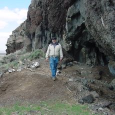
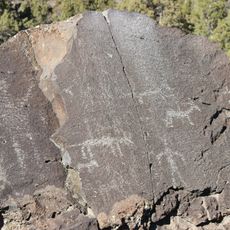
Artifacts found along the eastern shore show that people lived in this area for thousands of years and adapted to its harsh conditions. These discoveries reveal how communities thrived near the lake despite its extreme salinity.

The lake can be viewed from several observation points along a nearby highway that offer easy access for visitors. These locations are good for watching birds and landscapes without needing to hike far.

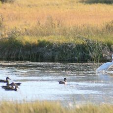
The water is home to unusual small organisms that can survive in few other places, including tiny crustaceans and specialized insects. These creatures are adapted to the extreme salinity and form a food source for millions of migratory birds that pass through each year.

The community of curious travelers

AroundUs brings together thousands of curated places, local tips, and hidden gems, enriched daily by 60,000 contributors worldwide.

Start exploring
Location
GPS coordinates
42.64167,-120.22500
Latest update
December 8, 2025 13:43
Around this place
Paisley Caves
United States of America

Paisley Caves

29.8 km
Crack in the Ground
United States of America

Crack in the Ground

84.1 km
Summer Lake Hot Springs
United States of America

Summer Lake Hot Springs

35.8 km
Fossil Lake
United States of America

Fossil Lake

79.2 km
Lost Forest Research Natural Area
United States of America

Lost Forest Research Natural Area

82.6 km
Hart Mountain National Antelope Refuge
United States of America

Hart Mountain National Antelope Refuge

47.7 km
Summer Lake Wildlife Area
United States of America

Summer Lake Wildlife Area

55.9 km
Gearhart Mountain Wilderness
United States of America

Gearhart Mountain Wilderness

54.2 km
Abert Rim
United States of America

Abert Rim

28.2 km
David L. Shirk Ranch
United States of America

David L. Shirk Ranch

73.3 km
Picture Rock Pass Petroglyphs Site
United States of America

Picture Rock Pass Petroglyphs Site

65 km
Fandango Pass
United States of America

Fandango Pass

93.5 km
Greaser Petroglyph Site
United States of America

Greaser Petroglyph Site

61.5 km
Camp Warner
United States of America

Camp Warner

47 km
Goose Lake State Recreation Area
United States of America

Goose Lake State Recreation Area

72.5 km
Chandler State Wayside
United States of America

Chandler State Wayside

26.7 km
Hunter's Hot Springs
United States of America

Hunter's Hot Springs

48.3 km
Stone Bridge and the Oregon Central Military Wagon Road
United States of America

Stone Bridge and the Oregon Central Military Wagon Road

45 km
Gerber Reservoir
United States of America

Gerber Reservoir

87.3 km
Booth State Scenic Corridor
United States of America

Booth State Scenic Corridor

58.3 km
Goose Lake meteorite
United States of America

Goose Lake meteorite

78.1 km
Deep Creek Falls
United States of America

Deep Creek Falls

56.8 km
Bly Ranger Station
United States of America

Bly Ranger Station

72.5 km
Lake County Round Sale Barn
United States of America

Lake County Round Sale Barn

50.9 km
John N. and Cornelia Watson House
United States of America

John N. and Cornelia Watson House

51.3 km
Ed Eskelin Ranch
United States of America

Ed Eskelin Ranch

87.9 km
William P. Heryford House
United States of America

William P. Heryford House

51.4 km
Alger Theatre
United States of America

Alger Theatre

51.4 km
Show the full map
Reviews
Share your experience

No review yet

Discussions
Start a discussion...

No discussion yet

« Lake Abert - Saline lake in Lake County, Oregon » is provided by Around Us (aroundus.com). Images and texts are derived from Wikimedia project under a Creative Commons license. You are allowed to copy, distribute, and modify copies of this page, under the conditions set by the license, as long as this note is clearly visible.

Discover hidden gems everywhere you go!

From secret cafés to breathtaking viewpoints, skip the crowded tourist spots and find places that match your style. Our app makes it easy with voice search, smart filtering, route optimization, and insider tips from travelers worldwide. Download now for the complete mobile experience.

Around Us App Screenshot

A unique approach to discovering new places

Le Figaro

All the places worth exploring

France Info

A tailor-made excursion in just a few clicks

20 Minutes

Around Us
Travel Guide & Maps
Download

Send to your phone

QR Code
1

Open the camera app on your mobile.

2

Point at the QR code with your camera. A notification will appear.

3

Tap the notification to open the link.