Madhabkunda waterfall

Log in to your account

AroundUs is a community-driven map of interesting places, built by curious explorers like you. It grows with every review, story, and photo you share.
Connect to save your favorite spots, contribute locations, and create personalized routes.
By continuing, you accept our Terms and Conditions and our Privacy Policy

Madhabkunda waterfall

Add to collection
Map
Suggest a change
Share

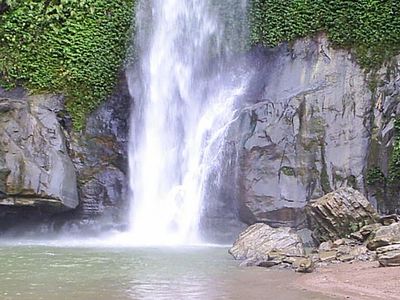
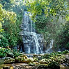
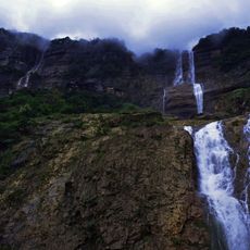
Madhabkunda waterfall, Natural waterfall in Barlekha, Moulvibazar District, Bangladesh.

Madhabkunda waterfall drops through several tiers approximately 162 feet down from Patharia Hill via the Gangamara stream, forming pools at each level as the water descends. The cascade splits into different channels depending on water volume and seasonal flow patterns.

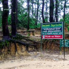
The area came under protection in 2001 when the Forest Department established a conservation area covering over 250 hectares around the site. This designation aimed to safeguard the forest and waterways from increasing human pressure.

The Khasia people who live in nearby villages wear colorful traditional clothing and maintain craft practices that shape daily life in the area. Their settlements are woven into the forest landscape, creating a distinct human presence within the natural surroundings.

Access is easiest by train to Kulaura Junction, then by shared microbus through tea gardens and forested terrain for about an hour. Wear sturdy shoes as pathways become slippery, especially during and after rain.

The waterfall transforms seasonally, spawning extra streams during monsoon rains that dramatically expand the cascade, while maintaining a steady primary flow year-round. This means the view changes significantly depending on when you visit.

GPS coordinates: 24.63917,92.22111

Latest update: December 6, 2025 16:04

Photos
Photography locations in Bangladesh

Bangladesh extends from the Brahmaputra delta to the hills near the Myanmar border. The country combines historical structures with natural settings that suit photography. In Dhaka, mosques from the 17th century stand near buildings from the 20th century. The coast shows long sandy beaches and small islands in the Bay of Bengal. In the northeast, tea plantations sit on gentle hills, while wetlands and swamps become water-covered landscapes during the monsoon season. Places like Lalbagh Fort and Ahsan Manzil document the Mughal era and colonial influences in the capital. The Sixty Dome Mosque in Bagerhat dates from the 15th century and shows early Islamic architecture in the region. Jatiyo Sangsad Bhaban, the parliament building by Louis Kahn, represents modern design. Natural areas like Ratargul Swamp Forest or the tea gardens near Srimangal offer different subjects. Cox's Bazar beach stretches for many miles (kilometers) along the coast. Saint Martin Island lies farther south in the sea. Sajek Valley in the Chittagong Hill Tracts shows mountainous terrain with views over forested slopes.

Reviews

Visited this place? Tap the stars to rate it and share your experience / photos with the community! Try now! You can cancel it anytime.

« Madhabkunda waterfall - Natural waterfall in Barlekha, Moulvibazar District, Bangladesh » is provided by Around Us (aroundus.com). Images and texts are derived from Wikimedia project under a Creative Commons license. You are allowed to copy, distribute, and modify copies of this page, under the conditions set by the license, as long as this note is clearly visible.

Discover hidden gems everywhere you go!

From secret cafés to breathtaking viewpoints, skip the crowded tourist spots and find places that match your style. Our app makes it easy with voice search, smart filtering, route optimization, and insider tips from travelers worldwide. Download now for the complete mobile experience.

Around Us App Screenshot

A unique approach to discovering new places

Le Figaro

All the places worth exploring

France Info

A tailor-made excursion in just a few clicks

20 Minutes