See the monuments around you in AROpen chests in the app
Around Us is built for your phone — point your camera at the streets and discover the monuments and places around you in augmented reality.Around Us is built for your phone — chests unlock when you walk, explore and capture nearby places.
Scottish Highlands: Hidden places, isolated mountains and remote villages
The Scottish Highlands span thousands of square miles in northern Scotland, offering striking landscapes of mountains, jagged coastlines, and remote lakes. This region retains villages that only recently gained road access, such as Rhenigidale on Harris Island, connected to the rest of the island in 1989. The Knoydart Peninsula remains accessible only by boat or on foot and has about a hundred residents.
Notable sites include the Torridon hills, formed of red sandstone and rising roughly 1,000 meters (3,280 feet), the Bealach na Bà road which climbs to 626 meters (2,054 feet) with slopes up to 20 percent, and Sandwood Bay, a sandy beach reachable after several miles of walking. The Speyside Way stretches 85 miles (137 km) along the River Spey, passing through forests and moorlands near whisky distilleries. On the Isle of Skye, the Storr features needle-shaped rock formations, while Coire Lagan forms a glacial cirque carved into the rock. These sites highlight the region’s geological history and the ways of life that have persisted despite isolation.
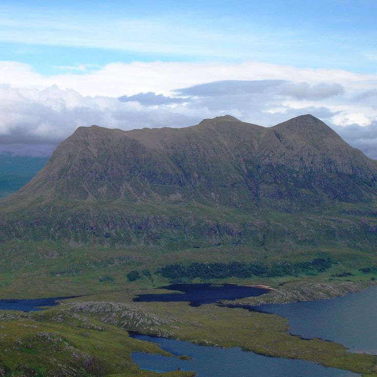
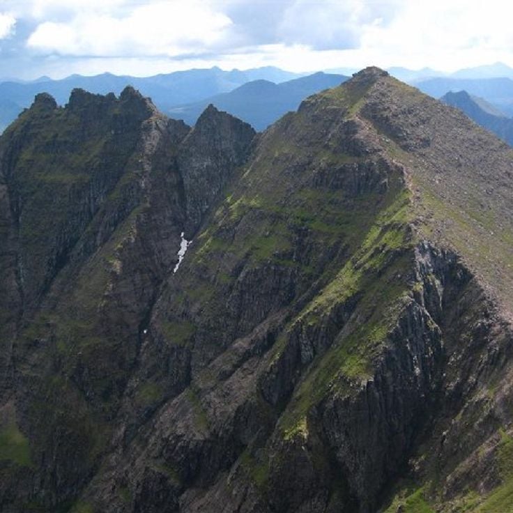
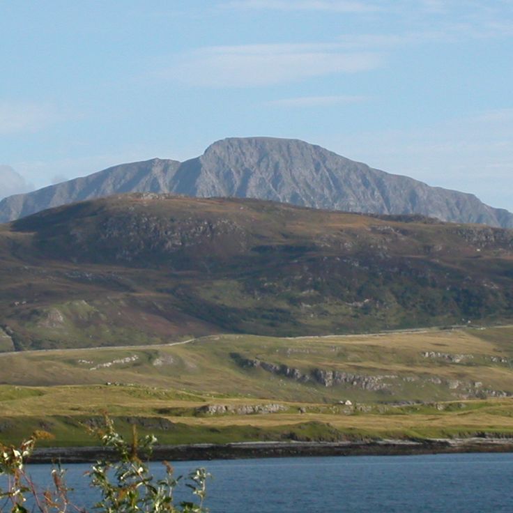
These mountains in Wester Ross are composed of red sandstone and reach elevations of approximately 3,300 feet (1,000 meters). The formations date back some 750 million years and rank among Scotland's oldest rock structures. Several trails traverse the nature reserve, including routes to Beinn Eighe and Liathach. The steep flanks and narrow ridges require hillwalking experience. From the summits, views extend across Loch Torridon and the surrounding glens. The area lies roughly 60 miles (100 kilometers) west of Inverness and is accessible via the A896.
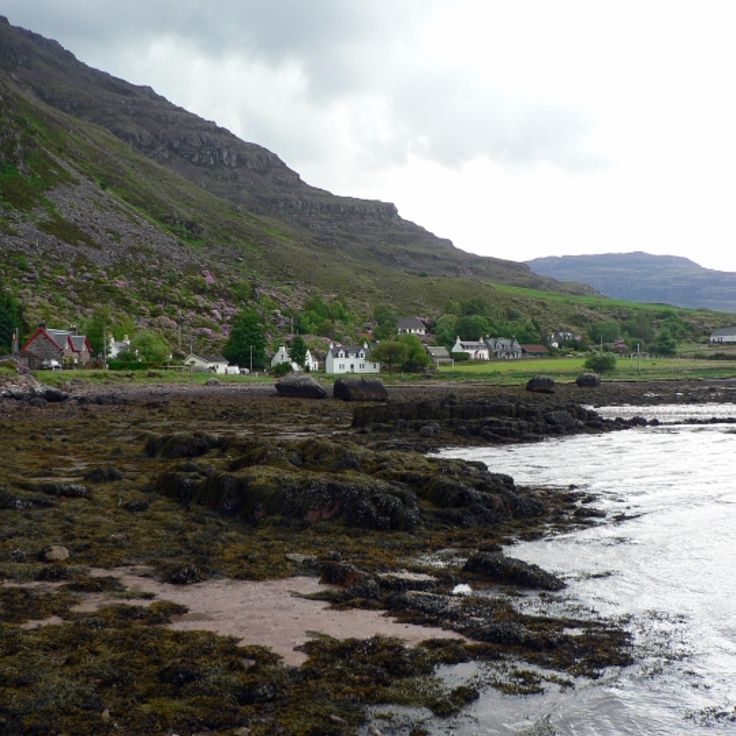
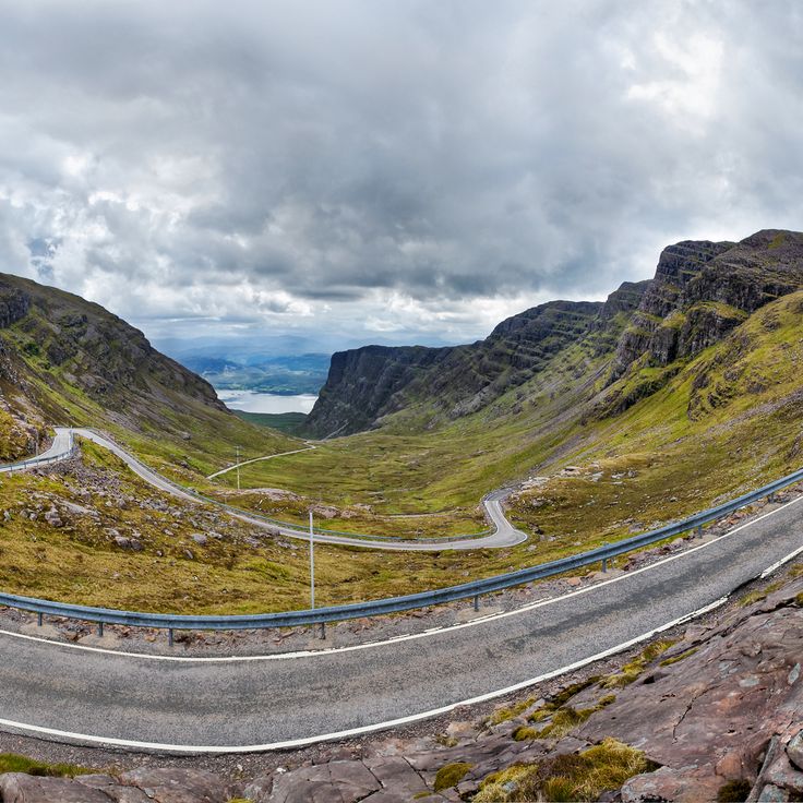
This mountain road climbs to 2,054 feet (626 meters) and ranks among the steepest paved routes in Scotland. The pass connects the west coast with the Applecross peninsula through a series of tight switchbacks that cut through highland terrain. Sections of the road reach gradients of 20 percent. Winter weather often makes the pass impassable, and snow can close the route for days or weeks at a time.
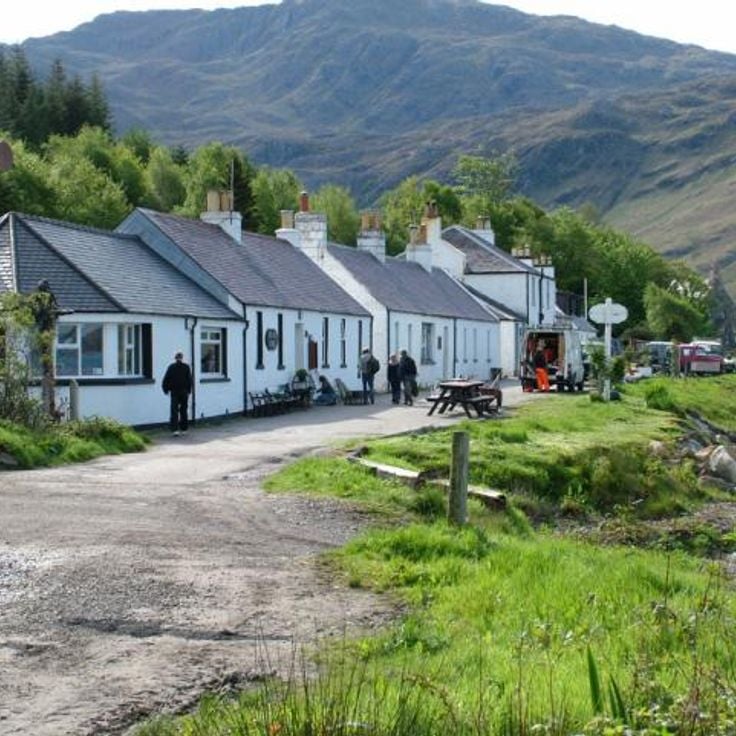
This village on the east coast of Harris remained without road access until 1989, leaving residents and visitors reliant on a four-mile (six-kilometer) coastal path to Tarbert. The old postal route runs along the cliffs overlooking the Minch, connecting the settlement to the rest of the island. A single-track road now reaches the village, but the walking trail remains a popular route for those exploring the remote coastal terrain of Harris.
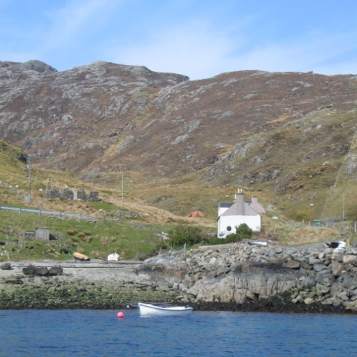
This peninsula remains one of Scotland's few regions without road connection to the mainland. The Knoydart Peninsula is accessible only by boat or via multi-hour walking trails, and supports approximately one hundred permanent residents. Three mountains exceed 900 meters (2950 feet), and several freshwater lochs occupy the valleys between the peaks. The area receives supplies by ferry from Mallaig, and the isolation has maintained a functioning community that has existed for decades without direct road access.
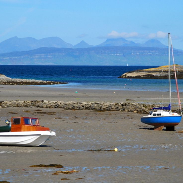
The Small Isles lie off Scotland's west coast and comprise four inhabited islands: Rum, Eigg, Muck and Canna. Rum covers roughly 40 square miles (105 square kilometers) and supports a red deer population numbering several thousand. On Eigg, the Sgùrr rises 1,289 feet (393 meters) as a pitchstone rock formation. Muck counts around 30 permanent residents and sits as the southernmost island of the group. Canna serves as a navigation point for coastal shipping and has a natural harbor. Ferry services from Mallaig connect the islands, with crossing times ranging from 45 minutes to two hours depending on the destination.
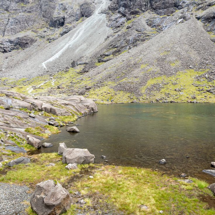
Coire Lagan is a glacial cirque cut into the heart of the Cuillin mountains on the Isle of Skye, carved by ice during the last glacial period into dark gabbro rock. The cirque sits at roughly 2,000 feet (600 meters) and is surrounded by steep rock walls that rise another 1,000 feet (300 meters). A small loch fills the floor of the cirque, while the surrounding peaks offer views across the Minch to the Outer Hebrides. Access follows a trail of about 2.5 miles (4 kilometers) from Glen Brittle, crossing moorland and boulder fields.
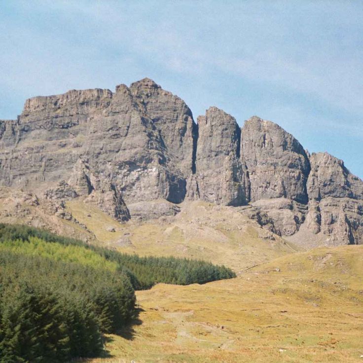
The Storr rises on the Isle of Skye with its distinctive rock pinnacles, formed by landslides thousands of years ago. The most prominent formation, the Old Man of Storr, stands about 165 feet (50 meters) above the surrounding terrain. A maintained path leads from the parking area through moorland to the base of the rock formations, covering roughly 2 miles (3 kilometers) one way. These geological structures consist of basalt resting on older sedimentary layers, contributing to the characteristic instability of the terrain. The Storr belongs to the Trotternish Ridge, a volcanic mountain range extending along the eastern side of the island.
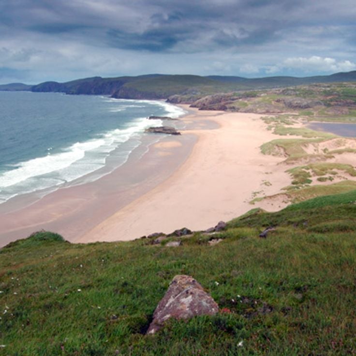
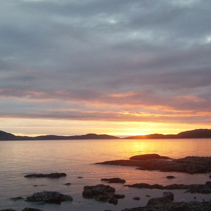
This sandy bay lies several miles from the nearest road on the northwestern coast of Sutherland. Access follows a walking trail covering roughly four miles (six kilometers) through moorland and heath. The beach stretches for nearly one mile (1.5 kilometers) and is bordered by dunes and cliffs. A rock stack rises from the water near the southern end of the bay. The remoteness has kept visitor numbers low and preserved the site's natural character.
Cape Wrath marks the northwestern tip of the Scottish mainland and rises above cliffs that reach roughly 400 feet (120 meters) above the Atlantic. The lighthouse dates from 1828 and was designed by engineer Robert Stevenson. The cliffs support colonies of puffins, razorbills and kittiwakes during the nesting season from April through August. A trail leads from the ferry landing at the Kyle of Durness through the Cape Wrath peninsula, which doubles as a training range for the British Ministry of Defence. Access is by ferry and minibus only, with the route closed during military exercises.
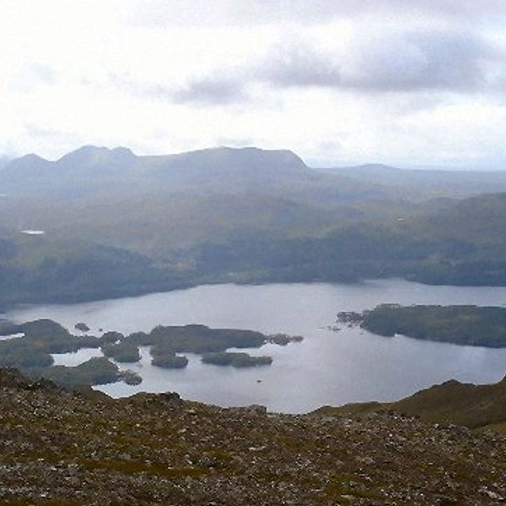
This loch in Ross-shire extends for 12 miles (20 kilometers) and contains more than 60 islands, several of which support ancient pine forests. The surrounding mountains rise to heights of approximately 3,300 feet (1,000 meters) and form one of the characteristic landscapes of the Scottish Highlands. The loch lies in an area shaped by glacial processes. Several walking trails follow the shores and provide access to the forested sections. The area around the loch belongs to the remote regions of the Highlands, where natural vegetation and mountain formations have developed over millennia.
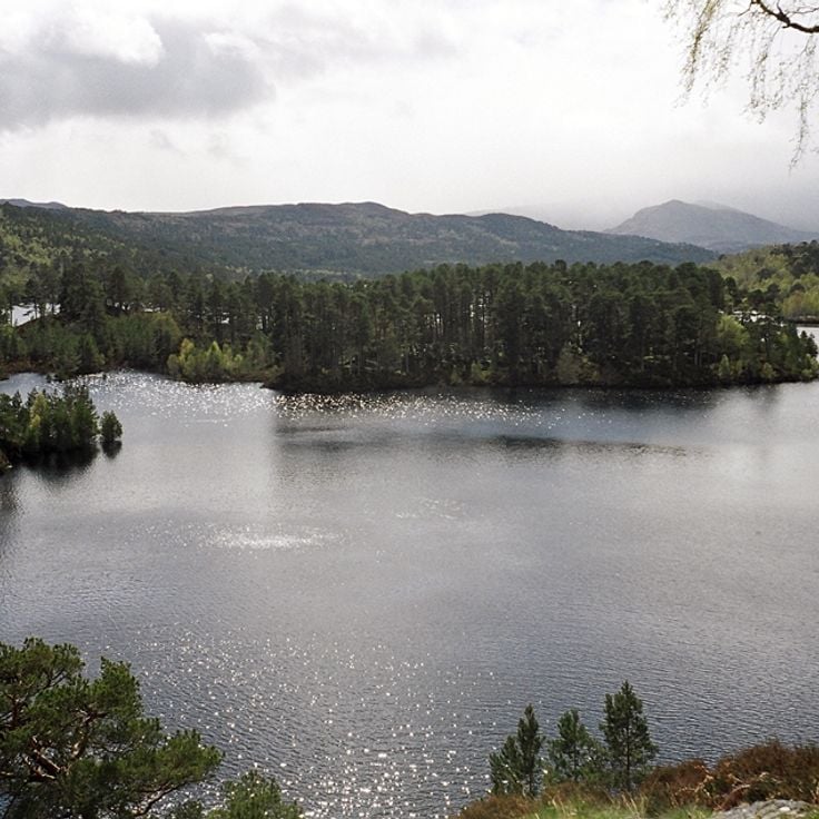
Glen Affric extends 30 miles (48 kilometers) through the Scottish Highlands and contains one of the largest remaining stands of Caledonian pines, trees that have grown in the region for thousands of years. The forest sections spread along the shores of Loch Affric and Loch Beinn a' Mheadhoin, forming woodlands interspersed with open moorland. This nature reserve supports golden eagles, red deer and other wildlife that inhabit the forested slopes and upland areas. Walking trails cross the landscape and connect the glen with surrounding mountains, where the terrain rises to elevations exceeding 3,000 feet (900 meters).
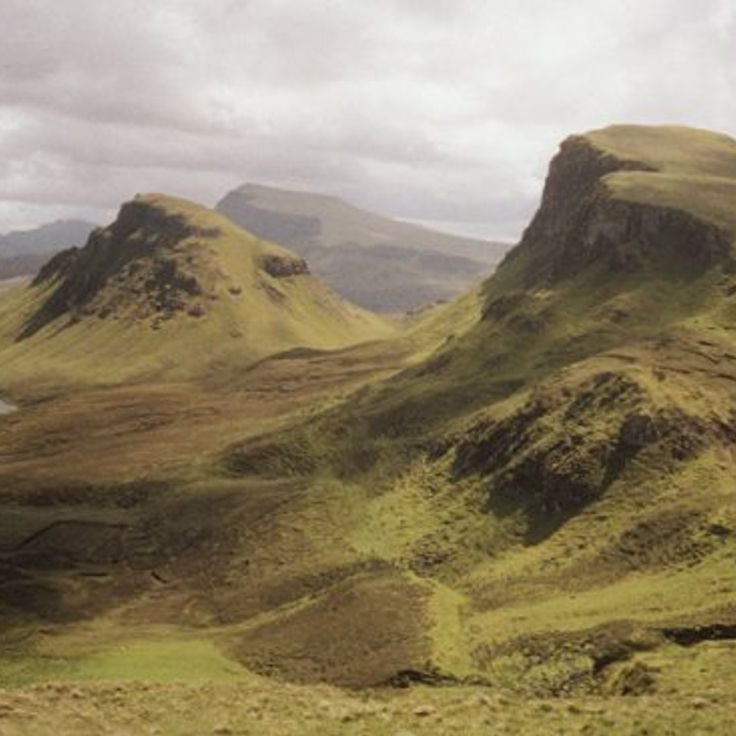
The Quiraing ranks among the less visited geological formations in the Scottish Highlands, located on the eastern slope of Meall na Suiramach on the Isle of Skye. The rock formation resulted from a landslide that left vertical cliffs and offset plateaus. Hiking trails cover roughly 4 miles (7 kilometers) through the terrain, passing freestanding rock towers and narrow passages between stone walls. From the higher sections, views extend across the coastline and offshore islands. Access follows a single-track road with passing places that winds uphill in switchbacks from Staffin.
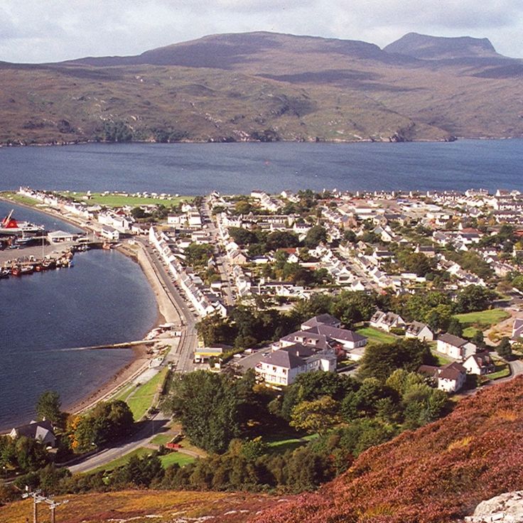
This fishing village on Loch Broom was established in 1788 as a planned settlement for the herring industry. The harbor remains operational, with fishing boats docking daily and ferries departing for Stornoway on Lewis. The cobbled Shore Street runs parallel to the water, lined with whitewashed 18th-century buildings. The village serves as a base for trips into the northern Highlands and to the Summer Isles, a cluster of uninhabited islands offshore. The population stands at approximately 1,500 residents, numbers swelling during summer months when hikers and boat passengers arrive.
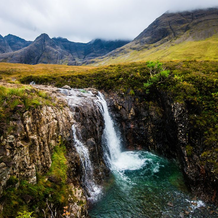
The Fairy Pools on the Isle of Skye form a series of natural cascades and turquoise basins at the foot of the Cuillin Mountains. Cold water flows down from the surrounding peaks, creating natural pools in the streambed of the Allt Coir' a' Mhadaidh. The path to these pools crosses moorland and offers views of the jagged Cuillin summits. The water's color results from minerals in the rock and light refraction in the clear mountain water. On sunny days some visitors swim in the frigid pools, though water temperature rarely exceeds 50°F (10°C) even in summer.
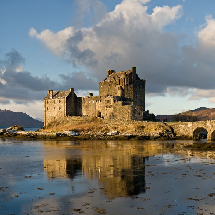
This castle occupies a small tidal island where three sea lochs converge, approximately 8 miles (13 kilometers) east of the Isle of Skye. A stone arched bridge built in the early 20th century connects Eilean Donan to the mainland. The original fortress dates to the 13th century, constructed as a defensive position against Norse incursions. Following its destruction in 1719 during the Jacobite risings, the ruins remained untouched for two centuries. Reconstruction began in 1912, guided by historical plans discovered in Edinburgh. The complex includes a central keep, enclosing walls and a small courtyard overlooking Loch Duich, Loch Long and Loch Alsh. The structure documents medieval Scottish fortification architecture and the history of the western Highlands clans.
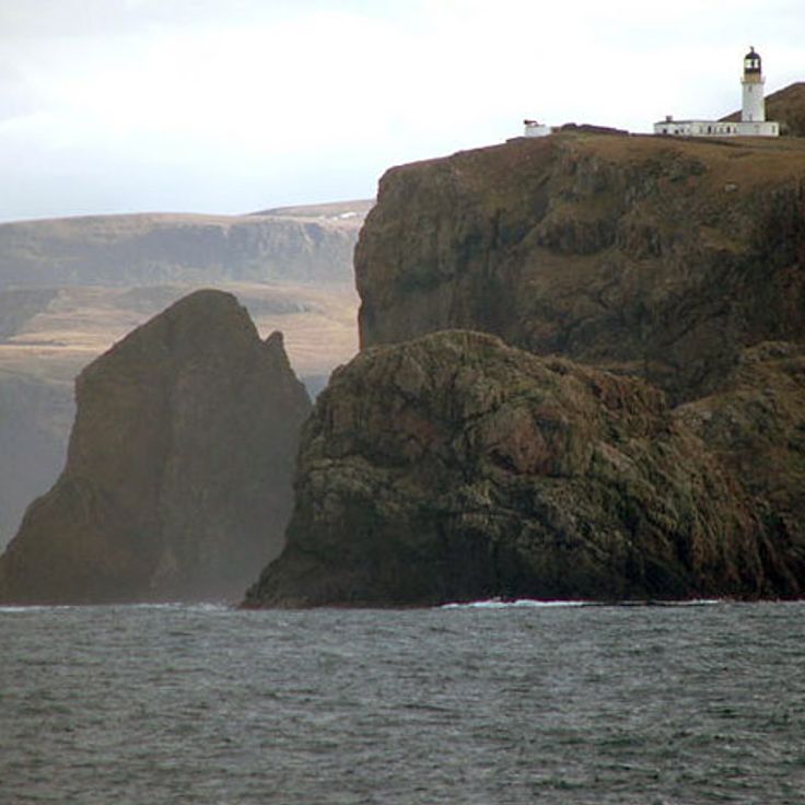
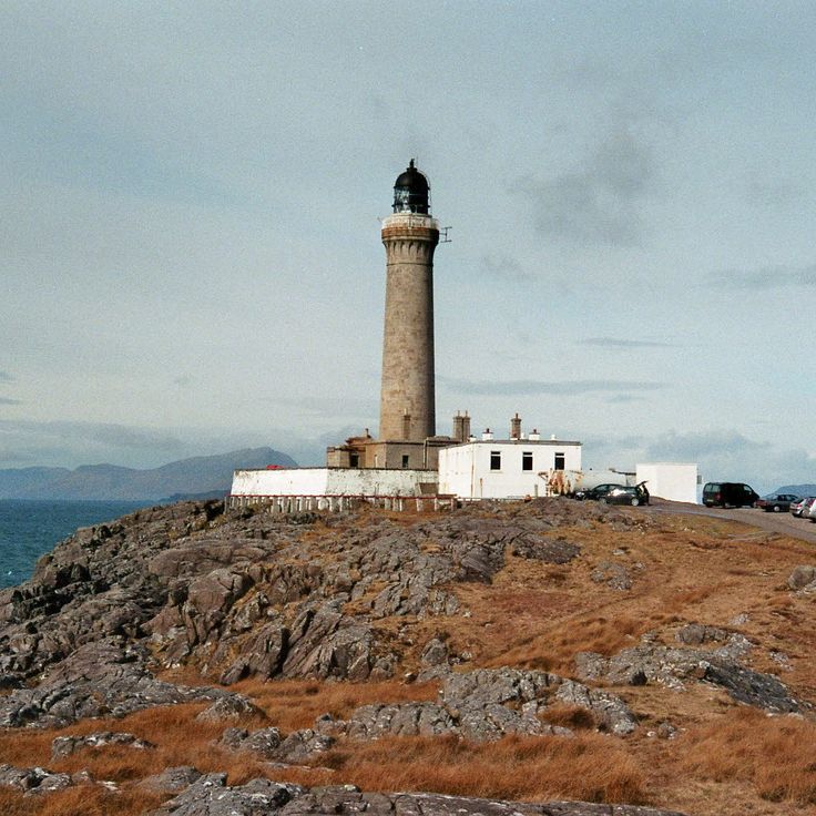
This 118-foot (36-meter) granite tower marks the westernmost point of the British mainland and was built in 1849 to guide vessels through the dangerous passage between the Scottish coast and the Hebrides. The light was automated in 1988 and now sends a signal across the sea every 20 seconds. The facility includes a visitor center housed in the former keepers' cottages, which documents the maritime history along this coast. The surrounding Ardnamurchan peninsula is reached by a single-track road that winds 25 miles (40 kilometers) through uninhabited terrain. From the lighthouse platform, views extend across the islands of Mull, Coll and Eigg, and on clear days to the Outer Hebrides.
An Teallach rises to 3,484 feet (1,062 meters) in the northern Scottish Highlands, forming multiple summits along a two-mile (three-kilometer) ridge of red sandstone. The mountain ranks among the remote peaks in this region, where thousands of square miles of mountain terrain remain sparsely inhabited. Climbers use various routes along the ridge, with ascents crossing steep rock faces and narrow sections. The red sandstone formed hundreds of millions of years ago and shapes the appearance of the massif. Access follows unpaved tracks through moorland several miles from the nearest road.
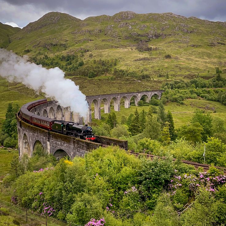
This concrete railway viaduct completed in 1898 extends 1,250 feet (380 meters) and rises 100 feet (30 meters) above the valley floor. The structure carries trains on the West Highland Line and demonstrates the engineering required to connect remote Highland regions to Glasgow, with trains still traversing this route through a landscape of mountains and lochs.
This freshwater loch extends 28 miles (45 kilometers) through the mountains of the Scottish Highlands, set between forested slopes and bare peaks. Golden eagles nest in the surrounding woods while salmon move through the water. The loch forms one of the longest bodies of water in the region and marks a natural boundary between different mountain groups. The area shows traces of former settlements, and several footpaths lead to viewpoints above the water. Loch Shiel remains off the main transport routes and is primarily explored by boat.
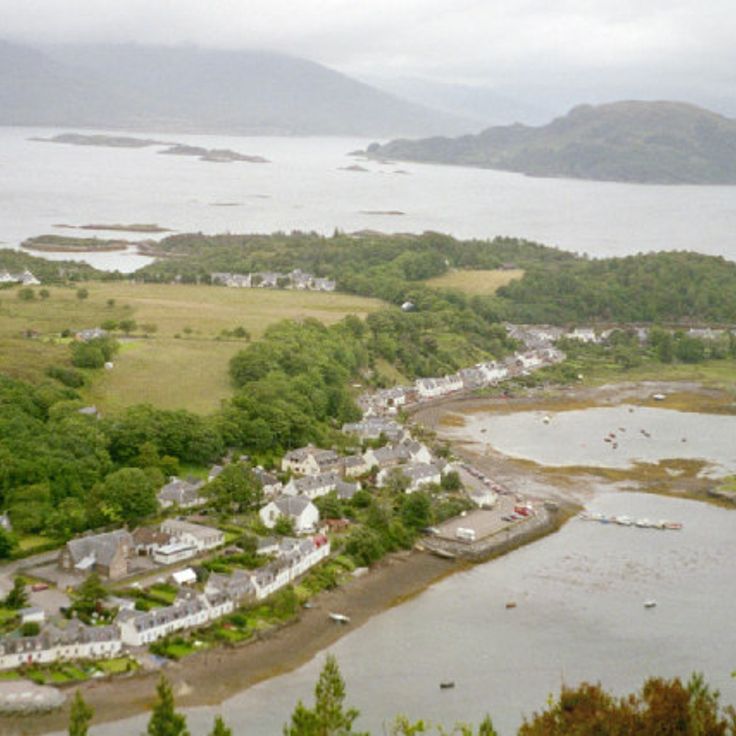
This fishing village sits on Loch Carron approximately 6 miles (10 kilometers) from Kyle of Lochalsh, benefiting from Gulf Stream currents that create a milder climate. Palm trees line the waterfront while the sheltered bay attracts seals that regularly appear on the rocks. Boat trips run to offshore islands, and coastal paths extend along the shoreline. The settlement developed as a fishing harbor in the 18th century and later became a filming location for several television and film productions.
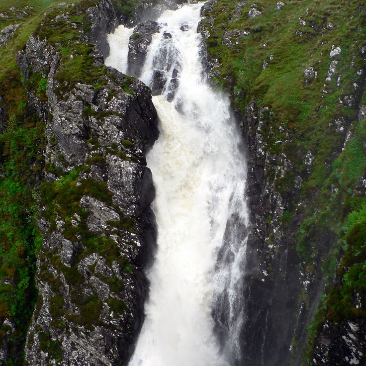
The Glomach Falls drop 370 feet (113 meters) into a steep gorge in the western Highlands, roughly 10 miles (16 kilometers) southeast of Dornie. A mountain trail covers 1.5 miles (2.5 kilometers) through the Kintail landscape, with hikers ascending several hundred feet in elevation. Water volume varies considerably depending on rainfall, and access requires caution on slippery sections during wet conditions. These remote falls rank among the highest in Scotland and demonstrate the geological forces that shaped the Highland terrain.
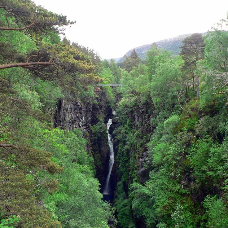
The Gorges de Corrieshalloch form a 200-foot (60 meter) gorge in the northern Scottish Highlands where the Measach Falls drop into a narrow valley flanked by wooded slopes. A suspension bridge built in 1874 spans the gorge and offers views of the waterfall and surrounding geology. The gorge was carved by glacial meltwater during the last ice age, cutting deep channels through softer rock layers. A walking path leads from the parking area to the bridge and several viewpoints along the rim. This geological feature lies southeast of Ullapool on the road to Inverness and represents one of several examples of postglacial landscape formation in this remote area of the Highlands. The site has been managed by the National Trust for Scotland since 1945 and receives visitors year round despite its location in a sparsely populated region.
Ben Hope rises to 3,041 feet (927 meters) as an isolated summit in northern Sutherland, marking Scotland's most northerly Munro. The ascent begins at Loch Hope and crosses open moorland before steep grass slopes lead to the rocky summit plateau. From the top, views extend across the Flow Country peatlands, to the north coast and on clear days to the Orkney Islands. The exposed location makes the mountain prone to weather changes, and mist can roll in quickly.
The Summer Isles stretch across waters off the northwest coast and consist of 17 small islands, most of which are uninhabited. Several islands reach heights of approximately 430 feet above sea level. The archipelago serves as habitat for seabirds and seals that find shelter on the rocky outcrops and in protected bays. The main island, Tanera Mòr, was permanently inhabited until the 1930s and supported a small fishing community. Today only a few people live there during summer months. The islands lie within a marine protected area that encompasses waters around the archipelago. Boat trips from Ullapool provide access to some of the islands and offer insight into the natural habitats of this remote landscape.
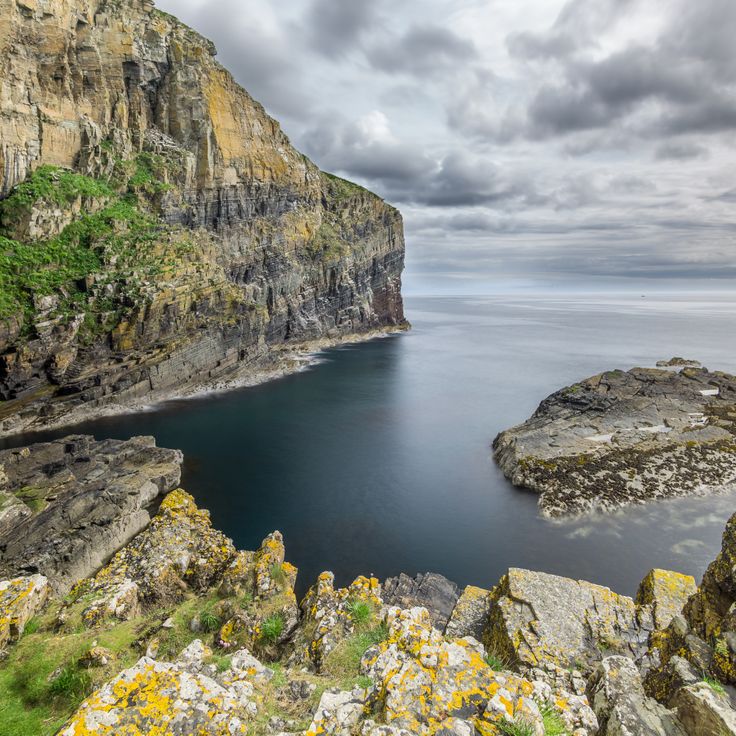
These stone steps were cut in the 18th century to move herring from a small harbor at the base of the cliffs to salting stations on the plateau above. The 330 steps descend 250 feet (75 meters) through the rock face and were used by fisherwomen who climbed up and down daily carrying heavy baskets on their backs. The harbor below provided shelter for small boats during the herring fishing season in the 19th century, when this stretch of Caithness coast depended economically on the catch. The steps remain walkable today and demonstrate the physical demands faced by residents of this remote Highlands coastline.
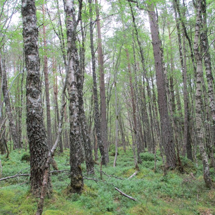
This ancient pine forest in the Scottish Highlands covers twelve square miles (31 square kilometers) along the edge of Rannoch Moor. The Forêt Noire de Rannoch preserves remnants of the original Caledonian woodland that once blanketed much of Scotland. Scots pines dominate the canopy, while the understory shelters rare plant species including twinflower and creeping lady's tresses. Wildlife includes red deer, black grouse, Scottish crossbills and occasional pine martens. The forest sits at roughly 1,000 feet (300 meters) elevation and displays characteristic features of Highland woodlands, with moss-covered rocks and scattered birch trees interspersed among the dominant pines.
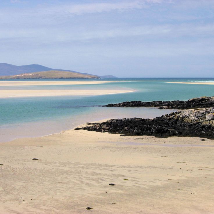
Luskentyre Beach extends for three kilometers (1.9 miles) along the western coast of Harris, forming one of the largest continuous sand stretches in the Outer Hebrides. The dunes rise to heights of 130 feet (40 meters) above sea level and border tidal flats that extend several hundred yards at low tide. The water displays a turquoise color due to the light sand bottom and low sediment content. The beach sits at the end of a single-track road and receives its sand from crushed seashells, explaining the white appearance. At low tide, sandbars connect the bay to offshore islands.
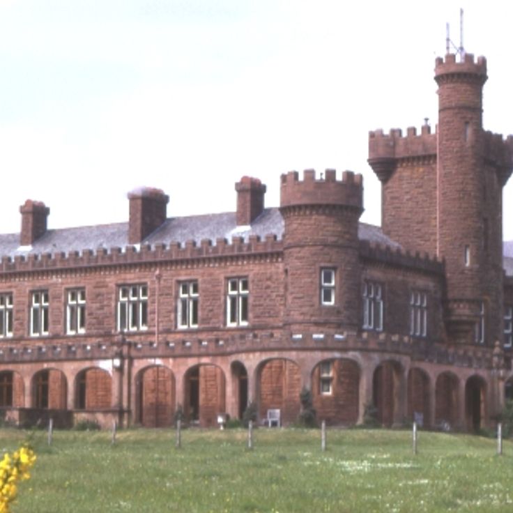
This red sandstone residence was built in 1897 by George Bullough on the Isle of Rum and now stands on the west coast of the Scottish Highlands. The building contains Edwardian period furniture and a ballroom with a mechanical organ. The estate documents the lifestyle of wealthy industrialists at the end of the 19th century and sits on one of the most remote inhabited islands of the Inner Hebrides, accessible only by ferry.
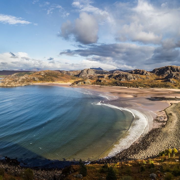
This bay sits on the western coast of Ross and Cromarty and features reddish sand derived from the iron-bearing sandstone formations in the area. The water is clear enough for swimming, though temperatures remain cool year-round. From the bay, the Summer Isles are visible, a group of small islands located roughly 2 miles (3 kilometers) offshore. The bay is accessible via a minor road and provides beach access through a short walk. The area forms part of the less populated sections of the Scottish west coast.
Cul Mor rises to 2,786 feet (849 meters) in the Assynt region of the Scottish Highlands, formed from Torridonian sandstone that dates back over a billion years. The trail to the summit crosses open moorland, offering views of neighboring peaks including Suilven and Stac Pollaidh. This mountain's distinctive reddish sandstone layers reflect the ancient geology of this remote area. The ascent and descent typically require several hours, passing through terrain shaped by glacial activity that carved the valleys and corries of the northwestern Highlands.
These mountains in Wester Ross are composed of red sandstone and reach elevations of approximately 3,300 feet (1,000 meters). The formations date back some 750 million years and rank among Scotland's oldest rock structures. Several trails traverse the nature reserve, including routes to Beinn Eighe and Liathach. The steep flanks and narrow ridges require hillwalking experience. From the summits, views extend across Loch Torridon and the surrounding glens. The area lies roughly 60 miles (100 kilometers) west of Inverness and is accessible via the A896.
This mountain road climbs to 2,054 feet (626 meters) and ranks among the steepest paved routes in Scotland. The pass connects the west coast with the Applecross peninsula through a series of tight switchbacks that cut through highland terrain. Sections of the road reach gradients of 20 percent. Winter weather often makes the pass impassable, and snow can close the route for days or weeks at a time.
This village on the east coast of Harris remained without road access until 1989, leaving residents and visitors reliant on a four-mile (six-kilometer) coastal path to Tarbert. The old postal route runs along the cliffs overlooking the Minch, connecting the settlement to the rest of the island. A single-track road now reaches the village, but the walking trail remains a popular route for those exploring the remote coastal terrain of Harris.
This peninsula remains one of Scotland's few regions without road connection to the mainland. The Knoydart Peninsula is accessible only by boat or via multi-hour walking trails, and supports approximately one hundred permanent residents. Three mountains exceed 900 meters (2950 feet), and several freshwater lochs occupy the valleys between the peaks. The area receives supplies by ferry from Mallaig, and the isolation has maintained a functioning community that has existed for decades without direct road access.
The Small Isles lie off Scotland's west coast and comprise four inhabited islands: Rum, Eigg, Muck and Canna. Rum covers roughly 40 square miles (105 square kilometers) and supports a red deer population numbering several thousand. On Eigg, the Sgùrr rises 1,289 feet (393 meters) as a pitchstone rock formation. Muck counts around 30 permanent residents and sits as the southernmost island of the group. Canna serves as a navigation point for coastal shipping and has a natural harbor. Ferry services from Mallaig connect the islands, with crossing times ranging from 45 minutes to two hours depending on the destination.
Coire Lagan is a glacial cirque cut into the heart of the Cuillin mountains on the Isle of Skye, carved by ice during the last glacial period into dark gabbro rock. The cirque sits at roughly 2,000 feet (600 meters) and is surrounded by steep rock walls that rise another 1,000 feet (300 meters). A small loch fills the floor of the cirque, while the surrounding peaks offer views across the Minch to the Outer Hebrides. Access follows a trail of about 2.5 miles (4 kilometers) from Glen Brittle, crossing moorland and boulder fields.
The Storr rises on the Isle of Skye with its distinctive rock pinnacles, formed by landslides thousands of years ago. The most prominent formation, the Old Man of Storr, stands about 165 feet (50 meters) above the surrounding terrain. A maintained path leads from the parking area through moorland to the base of the rock formations, covering roughly 2 miles (3 kilometers) one way. These geological structures consist of basalt resting on older sedimentary layers, contributing to the characteristic instability of the terrain. The Storr belongs to the Trotternish Ridge, a volcanic mountain range extending along the eastern side of the island.
This sandy bay lies several miles from the nearest road on the northwestern coast of Sutherland. Access follows a walking trail covering roughly four miles (six kilometers) through moorland and heath. The beach stretches for nearly one mile (1.5 kilometers) and is bordered by dunes and cliffs. A rock stack rises from the water near the southern end of the bay. The remoteness has kept visitor numbers low and preserved the site's natural character.
Cape Wrath marks the northwestern tip of the Scottish mainland and rises above cliffs that reach roughly 400 feet (120 meters) above the Atlantic. The lighthouse dates from 1828 and was designed by engineer Robert Stevenson. The cliffs support colonies of puffins, razorbills and kittiwakes during the nesting season from April through August. A trail leads from the ferry landing at the Kyle of Durness through the Cape Wrath peninsula, which doubles as a training range for the British Ministry of Defence. Access is by ferry and minibus only, with the route closed during military exercises.
This loch in Ross-shire extends for 12 miles (20 kilometers) and contains more than 60 islands, several of which support ancient pine forests. The surrounding mountains rise to heights of approximately 3,300 feet (1,000 meters) and form one of the characteristic landscapes of the Scottish Highlands. The loch lies in an area shaped by glacial processes. Several walking trails follow the shores and provide access to the forested sections. The area around the loch belongs to the remote regions of the Highlands, where natural vegetation and mountain formations have developed over millennia.
Glen Affric extends 30 miles (48 kilometers) through the Scottish Highlands and contains one of the largest remaining stands of Caledonian pines, trees that have grown in the region for thousands of years. The forest sections spread along the shores of Loch Affric and Loch Beinn a' Mheadhoin, forming woodlands interspersed with open moorland. This nature reserve supports golden eagles, red deer and other wildlife that inhabit the forested slopes and upland areas. Walking trails cross the landscape and connect the glen with surrounding mountains, where the terrain rises to elevations exceeding 3,000 feet (900 meters).
The Quiraing ranks among the less visited geological formations in the Scottish Highlands, located on the eastern slope of Meall na Suiramach on the Isle of Skye. The rock formation resulted from a landslide that left vertical cliffs and offset plateaus. Hiking trails cover roughly 4 miles (7 kilometers) through the terrain, passing freestanding rock towers and narrow passages between stone walls. From the higher sections, views extend across the coastline and offshore islands. Access follows a single-track road with passing places that winds uphill in switchbacks from Staffin.
This fishing village on Loch Broom was established in 1788 as a planned settlement for the herring industry. The harbor remains operational, with fishing boats docking daily and ferries departing for Stornoway on Lewis. The cobbled Shore Street runs parallel to the water, lined with whitewashed 18th-century buildings. The village serves as a base for trips into the northern Highlands and to the Summer Isles, a cluster of uninhabited islands offshore. The population stands at approximately 1,500 residents, numbers swelling during summer months when hikers and boat passengers arrive.
The Fairy Pools on the Isle of Skye form a series of natural cascades and turquoise basins at the foot of the Cuillin Mountains. Cold water flows down from the surrounding peaks, creating natural pools in the streambed of the Allt Coir' a' Mhadaidh. The path to these pools crosses moorland and offers views of the jagged Cuillin summits. The water's color results from minerals in the rock and light refraction in the clear mountain water. On sunny days some visitors swim in the frigid pools, though water temperature rarely exceeds 50°F (10°C) even in summer.
This castle occupies a small tidal island where three sea lochs converge, approximately 8 miles (13 kilometers) east of the Isle of Skye. A stone arched bridge built in the early 20th century connects Eilean Donan to the mainland. The original fortress dates to the 13th century, constructed as a defensive position against Norse incursions. Following its destruction in 1719 during the Jacobite risings, the ruins remained untouched for two centuries. Reconstruction began in 1912, guided by historical plans discovered in Edinburgh. The complex includes a central keep, enclosing walls and a small courtyard overlooking Loch Duich, Loch Long and Loch Alsh. The structure documents medieval Scottish fortification architecture and the history of the western Highlands clans.
This 118-foot (36-meter) granite tower marks the westernmost point of the British mainland and was built in 1849 to guide vessels through the dangerous passage between the Scottish coast and the Hebrides. The light was automated in 1988 and now sends a signal across the sea every 20 seconds. The facility includes a visitor center housed in the former keepers' cottages, which documents the maritime history along this coast. The surrounding Ardnamurchan peninsula is reached by a single-track road that winds 25 miles (40 kilometers) through uninhabited terrain. From the lighthouse platform, views extend across the islands of Mull, Coll and Eigg, and on clear days to the Outer Hebrides.
An Teallach rises to 3,484 feet (1,062 meters) in the northern Scottish Highlands, forming multiple summits along a two-mile (three-kilometer) ridge of red sandstone. The mountain ranks among the remote peaks in this region, where thousands of square miles of mountain terrain remain sparsely inhabited. Climbers use various routes along the ridge, with ascents crossing steep rock faces and narrow sections. The red sandstone formed hundreds of millions of years ago and shapes the appearance of the massif. Access follows unpaved tracks through moorland several miles from the nearest road.
This concrete railway viaduct completed in 1898 extends 1,250 feet (380 meters) and rises 100 feet (30 meters) above the valley floor. The structure carries trains on the West Highland Line and demonstrates the engineering required to connect remote Highland regions to Glasgow, with trains still traversing this route through a landscape of mountains and lochs.
This freshwater loch extends 28 miles (45 kilometers) through the mountains of the Scottish Highlands, set between forested slopes and bare peaks. Golden eagles nest in the surrounding woods while salmon move through the water. The loch forms one of the longest bodies of water in the region and marks a natural boundary between different mountain groups. The area shows traces of former settlements, and several footpaths lead to viewpoints above the water. Loch Shiel remains off the main transport routes and is primarily explored by boat.
This fishing village sits on Loch Carron approximately 6 miles (10 kilometers) from Kyle of Lochalsh, benefiting from Gulf Stream currents that create a milder climate. Palm trees line the waterfront while the sheltered bay attracts seals that regularly appear on the rocks. Boat trips run to offshore islands, and coastal paths extend along the shoreline. The settlement developed as a fishing harbor in the 18th century and later became a filming location for several television and film productions.
The Glomach Falls drop 370 feet (113 meters) into a steep gorge in the western Highlands, roughly 10 miles (16 kilometers) southeast of Dornie. A mountain trail covers 1.5 miles (2.5 kilometers) through the Kintail landscape, with hikers ascending several hundred feet in elevation. Water volume varies considerably depending on rainfall, and access requires caution on slippery sections during wet conditions. These remote falls rank among the highest in Scotland and demonstrate the geological forces that shaped the Highland terrain.
The Gorges de Corrieshalloch form a 200-foot (60 meter) gorge in the northern Scottish Highlands where the Measach Falls drop into a narrow valley flanked by wooded slopes. A suspension bridge built in 1874 spans the gorge and offers views of the waterfall and surrounding geology. The gorge was carved by glacial meltwater during the last ice age, cutting deep channels through softer rock layers. A walking path leads from the parking area to the bridge and several viewpoints along the rim. This geological feature lies southeast of Ullapool on the road to Inverness and represents one of several examples of postglacial landscape formation in this remote area of the Highlands. The site has been managed by the National Trust for Scotland since 1945 and receives visitors year round despite its location in a sparsely populated region.
Ben Hope rises to 3,041 feet (927 meters) as an isolated summit in northern Sutherland, marking Scotland's most northerly Munro. The ascent begins at Loch Hope and crosses open moorland before steep grass slopes lead to the rocky summit plateau. From the top, views extend across the Flow Country peatlands, to the north coast and on clear days to the Orkney Islands. The exposed location makes the mountain prone to weather changes, and mist can roll in quickly.
The Summer Isles stretch across waters off the northwest coast and consist of 17 small islands, most of which are uninhabited. Several islands reach heights of approximately 430 feet above sea level. The archipelago serves as habitat for seabirds and seals that find shelter on the rocky outcrops and in protected bays. The main island, Tanera Mòr, was permanently inhabited until the 1930s and supported a small fishing community. Today only a few people live there during summer months. The islands lie within a marine protected area that encompasses waters around the archipelago. Boat trips from Ullapool provide access to some of the islands and offer insight into the natural habitats of this remote landscape.
These stone steps were cut in the 18th century to move herring from a small harbor at the base of the cliffs to salting stations on the plateau above. The 330 steps descend 250 feet (75 meters) through the rock face and were used by fisherwomen who climbed up and down daily carrying heavy baskets on their backs. The harbor below provided shelter for small boats during the herring fishing season in the 19th century, when this stretch of Caithness coast depended economically on the catch. The steps remain walkable today and demonstrate the physical demands faced by residents of this remote Highlands coastline.
This ancient pine forest in the Scottish Highlands covers twelve square miles (31 square kilometers) along the edge of Rannoch Moor. The Forêt Noire de Rannoch preserves remnants of the original Caledonian woodland that once blanketed much of Scotland. Scots pines dominate the canopy, while the understory shelters rare plant species including twinflower and creeping lady's tresses. Wildlife includes red deer, black grouse, Scottish crossbills and occasional pine martens. The forest sits at roughly 1,000 feet (300 meters) elevation and displays characteristic features of Highland woodlands, with moss-covered rocks and scattered birch trees interspersed among the dominant pines.
Luskentyre Beach extends for three kilometers (1.9 miles) along the western coast of Harris, forming one of the largest continuous sand stretches in the Outer Hebrides. The dunes rise to heights of 130 feet (40 meters) above sea level and border tidal flats that extend several hundred yards at low tide. The water displays a turquoise color due to the light sand bottom and low sediment content. The beach sits at the end of a single-track road and receives its sand from crushed seashells, explaining the white appearance. At low tide, sandbars connect the bay to offshore islands.
This red sandstone residence was built in 1897 by George Bullough on the Isle of Rum and now stands on the west coast of the Scottish Highlands. The building contains Edwardian period furniture and a ballroom with a mechanical organ. The estate documents the lifestyle of wealthy industrialists at the end of the 19th century and sits on one of the most remote inhabited islands of the Inner Hebrides, accessible only by ferry.
This bay sits on the western coast of Ross and Cromarty and features reddish sand derived from the iron-bearing sandstone formations in the area. The water is clear enough for swimming, though temperatures remain cool year-round. From the bay, the Summer Isles are visible, a group of small islands located roughly 2 miles (3 kilometers) offshore. The bay is accessible via a minor road and provides beach access through a short walk. The area forms part of the less populated sections of the Scottish west coast.
Cul Mor rises to 2,786 feet (849 meters) in the Assynt region of the Scottish Highlands, formed from Torridonian sandstone that dates back over a billion years. The trail to the summit crosses open moorland, offering views of neighboring peaks including Suilven and Stac Pollaidh. This mountain's distinctive reddish sandstone layers reflect the ancient geology of this remote area. The ascent and descent typically require several hours, passing through terrain shaped by glacial activity that carved the valleys and corries of the northwestern Highlands.