Brno-Country District, Administrative district near Brno, Czech Republic
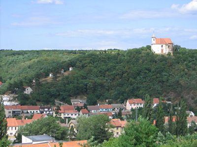
The Brno-Country District surrounds the city of Brno and forms a ring of rural municipalities and villages across the South Moravian Region. It spans varied terrain mixing farmland, forests, and vineyard areas that extend outward from the urban center.
The district took shape following administrative reforms in 1960 that consolidated several smaller units around Brno, the historical center of Moravia. It has since served as a key administrative division surrounding the regional capital.
Several wine-producing villages shape the area, where vineyards dot the landscape and local traditions remain visible during harvest season. Rural communities here maintain customs passed down through generations that continue to influence daily life.
The district connects to Brno through an integrated public transportation network serving about 187 municipalities with regular bus and train routes. Visitors can best explore the villages and countryside by using local transport services that depart from Brno.
Limestone formations and caves in the area belong to the Moravian Karst system, featuring underground rivers and natural passages beneath the surface. These geological structures create a hidden underground world that draws researchers and cave enthusiasts.
The community of curious travelers
AroundUs brings together thousands of curated places, local tips, and hidden gems, enriched daily by 60,000 contributors worldwide.