Chest opened
+${chestReward.xp} XP
Explorer
NOUVEAU ×${chestReward.collectible.quantity}
tapez pour fermer
Chest locked

Open chests in the app

Around Us is built for your phone — chests unlock when you walk, explore and capture nearby places.

Enable Location

We need your location to show you interesting places around you

Discover nearby places

Find interesting locations and hidden gems around you

Precise directions

Get accurate directions and distances to places

Your location is never shared with other users. It's only used when you tap the location button.

Log in to your account

Start exploring — it's free

Trusted by 73,035 travelers worldwide

Continue with Google
Continue with Apple
or

We will send you a code to connect

By continuing, you accept our Terms and Conditions and our Privacy Policy

Check your inbox

We've sent a pincode in your inbox. Please enter the code below.

Chimehuevis Landing, California
Discussion Reviews Photo
2.1k Popularity

Chimehuevis Landing, California, Space shuttle landing site in California, United States

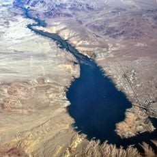
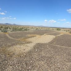
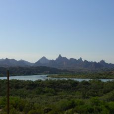
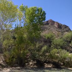
Chimehuevis Landing is a potential shuttle landing site situated on flat desert terrain near Lake Havasu in California. The location provides a wide, level surface suitable for spacecraft landings during emergency situations or missions requiring backup landing options.

The site was selected during the Space Shuttle program as an emergency landing option to provide backup capability for missions launched from the West Coast. This designation was part of a broader safety strategy to establish multiple landing locations along California.

The site links this remote desert area to America's space program, showing how local landscapes were incorporated into national aerospace goals. The designation reflected how communities far from urban centers played a role in supporting space exploration infrastructure.

This location is not open to the public and access is restricted due to its operational status as a designated aerospace facility. The site remains under governmental control and there are no visitor amenities or public access points available.

The location was chosen partly because its flat desert terrain provided natural advantages for shuttle landings and visibility during approach. Nearby Lake Havasu served as a geographic reference point that could help pilots navigate during emergency descent procedures.

The community of curious travelers

AroundUs brings together thousands of curated places, local tips, and hidden gems, enriched daily by 60,000 contributors worldwide.

Start exploring
GPS coordinates
34.45444,-114.38778
Latest update
December 14, 2025 09:45
Around this place
London Bridge
United States of America

London Bridge

4.2 km
Lake Havasu
United States of America

Lake Havasu

3.2 km
Central Arizona Project
United States of America

Central Arizona Project

32.1 km
Blythe Intaglios
United States of America

Blythe Intaglios

74.1 km
Colorado River Aqueduct
United States of America

Colorado River Aqueduct

27 km
Buckskin Mountain State Park
United States of America

Buckskin Mountain State Park

32 km
Old Woman Mountains Wilderness
United States of America

Old Woman Mountains Wilderness

74 km
The Needles
United States of America

The Needles

25.1 km
Havasu National Wildlife Refuge
United States of America

Havasu National Wildlife Refuge

39.2 km
Bigelow Cholla Garden Wilderness
United States of America

Bigelow Cholla Garden Wilderness

62.6 km
Cattail Cove State Park
United States of America

Cattail Cove State Park

23.1 km
Old Trails Bridge
United States of America

Old Trails Bridge

30.4 km
Bill Williams River National Wildlife Refuge
United States of America

Bill Williams River National Wildlife Refuge

35.5 km
Dead Mountains
United States of America

Dead Mountains

68 km
Red Rock Bridge
United States of America

Red Rock Bridge

30.8 km
United States of America

Topock Gorge

24.1 km
Turtle Mountains
United States of America

Turtle Mountains

46.5 km
Warm Springs Wilderness
United States of America

Warm Springs Wilderness

49.8 km
Boundary Cone
United States of America

Boundary Cone

59 km
Riverside Mountains
United States of America

Riverside Mountains

50 km
United States of America

Alexey W. Von Schmidt

67.2 km
Mohave Canyon
United States of America

Mohave Canyon

22.3 km
Oatman Drug Company Building
United States of America

Oatman Drug Company Building

63.6 km
Wegner Peak
United States of America

Wegner Peak

72.2 km
Bridgewater Links
United States of America

Bridgewater Links

4.2 km
Area 66
United States of America

Area 66

50.3 km
Riverview Resort Golf Course
United States of America

Riverview Resort Golf Course

74.8 km
Arizona and California Railroad Bridge
United States of America

Arizona and California Railroad Bridge

33.7 km
Show the full map
Reviews
Share your experience

No review yet

Discussions
Start a discussion...

No discussion yet

« Chimehuevis Landing, California - Space shuttle landing site in California, United States » is provided by Around Us (aroundus.com). Images and texts are derived from Wikimedia project under a Creative Commons license. You are allowed to copy, distribute, and modify copies of this page, under the conditions set by the license, as long as this note is clearly visible.

Discover hidden gems everywhere you go!

From secret cafés to breathtaking viewpoints, skip the crowded tourist spots and find places that match your style. Our app makes it easy with voice search, smart filtering, route optimization, and insider tips from travelers worldwide. Download now for the complete mobile experience.

Around Us App Screenshot

A unique approach to discovering new places

Le Figaro

All the places worth exploring

France Info

A tailor-made excursion in just a few clicks

20 Minutes

Around Us
Travel Guide & Maps
Download

Send to your phone

QR Code
1

Open the camera app on your mobile.

2

Point at the QR code with your camera. A notification will appear.

3

Tap the notification to open the link.