
Pasaband District, district of Afghanistan
Location: Ghōr
Elevation above the sea: 2,450 m
GPS coordinates: 33.69080,64.85640
Latest update: March 12, 2025 16:05

Minaret of Jam
84.6 km
Band-e Amir National Park
253.1 km
Shrine of the Cloak
244 km
Kandahar Bilingual Rock Inscription
243.1 km
Friday Mosque of Herat
256 km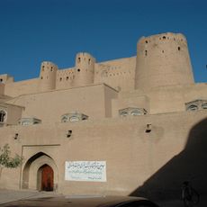
Herat Citadel
256.7 km
Mundigak
208.5 km
Tarnak Farms
264.9 km
Mousallah Complex
257.3 km
Yu Aw Synagogue
256.7 km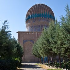
Gawhar Shad Mausoleum
257.4 km
Tomb of Ahmad Shah Durrani
244 km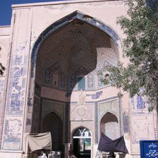
Khwaja 'Abd Allah Ansari shrine
253 km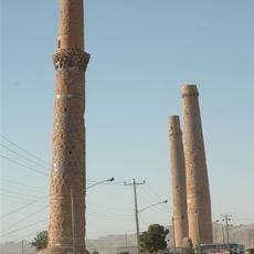
Musalla Minarets of Herat
257.3 km
Main Operating Base Price
210.2 km
Chil Zena
243.1 km
Forward Operating Base Edinburgh
235.2 km
Shahr-e Zuhak, Bamyan
300.7 km
Mosque of the Hair of the Prophet
244.7 km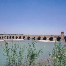
Malan bridge
254.8 km
Farah Citadel
294.6 km
Lashkar Gah Mosque
238.2 km
Paropamisus
132.8 km
Forward Operating Base Shawqat
235.2 km
Forward Operating Base Zeebrugge
181.4 km
Shāh Fōlādī
276.1 km
Forward Operating Base Arnhem
234.4 km
Qalat City Fort
260.1 kmReviews
Visited this place? Tap the stars to rate it and share your experience / photos with the community! Try now! You can cancel it anytime.
Discover hidden gems everywhere you go!
From secret cafés to breathtaking viewpoints, skip the crowded tourist spots and find places that match your style. Our app makes it easy with voice search, smart filtering, route optimization, and insider tips from travelers worldwide. Download now for the complete mobile experience.

A unique approach to discovering new places❞
— Le Figaro
All the places worth exploring❞
— France Info
A tailor-made excursion in just a few clicks❞
— 20 Minutes