Chest opened
+${chestReward.xp} XP
Explorer
NOUVEAU ×${chestReward.collectible.quantity}
tapez pour fermer
Chest locked

Open chests in the app

Around Us is built for your phone — chests unlock when you walk, explore and capture nearby places.

Enable Location

We need your location to show you interesting places around you

Discover nearby places

Find interesting locations and hidden gems around you

Precise directions

Get accurate directions and distances to places

Your location is never shared with other users. It's only used when you tap the location button.

Log in to your account

Start exploring — it's free

Trusted by 72,876 travelers worldwide

Continue with Google
Continue with Apple
or

We will send you a code to connect

By continuing, you accept our Terms and Conditions and our Privacy Policy

Check your inbox

We've sent a pincode in your inbox. Please enter the code below.

Tinayguk River
Discussion Reviews Photo
1.3k Popularity

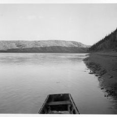
Tinayguk River, Mountain brook in Unorganized Borough, Alaska.

Tinayguk River is a mountain brook that winds through glacially carved valleys from the Endicott Mountains across Unorganized Borough in Alaska. It flows into the North Fork Koyukuk River at around 1,160 feet elevation.

The river received its current name in 1930 when forester Robert Marshall proposed renaming it during his exploration of the West Fork area. This designation was later established within Gates of the Arctic National Park.

The name comes from the Inupiat word for moose, reflecting the wildlife found throughout this remote Alaskan landscape. You can sense how important these animals are to understanding the region.

You can reach the river by hiking from Anaktuvuk Pass or North Fork Koyukuk, then using packrafts to navigate shallow waters and Class II rapids. Prepare for a physically demanding trip into remote terrain.

There are no aircraft landing areas here, so the river remains completely isolated and requires at least a 44-mile journey to reach it on foot or by raft. This total remoteness makes it one of the least visited waterways in Alaska.

The community of curious travelers

AroundUs brings together thousands of curated places, local tips, and hidden gems, enriched daily by 60,000 contributors worldwide.

Start exploring
GPS coordinates
67.75059,-151.44722
Latest update
December 14, 2025 17:40
Around this place
Arctic National Wildlife Refuge
United States of America

Arctic National Wildlife Refuge

345.9 km
Kobuk Valley National Park
United States of America

Kobuk Valley National Park

332.2 km
Fairbanks Gold Rush
United States of America

Fairbanks Gold Rush

352.7 km
Mount Isto
United States of America

Mount Isto

351.3 km
E. L. Patton Yukon River Bridge
United States of America

E. L. Patton Yukon River Bridge

222.2 km
Gates of the Arctic Wilderness
United States of America

Gates of the Arctic Wilderness

78.1 km
Goldstream Dredge No. 8
United States of America

Goldstream Dredge No. 8

355.9 km
Yukon Flats National Wildlife Refuge
United States of America

Yukon Flats National Wildlife Refuge

284.1 km
Mount Igikpak
United States of America

Mount Igikpak

154 km
Arrigetch Peaks
United States of America

Arrigetch Peaks

121.7 km
White Mountains National Recreation Area
United States of America

White Mountains National Recreation Area

306.9 km
Leffingwell Camp Site
United States of America

Leffingwell Camp Site

346 km
Noatak Wilderness
United States of America

Noatak Wilderness

340.9 km
Kanuti National Wildlife Refuge
United States of America

Kanuti National Wildlife Refuge

149.4 km
John River
United States of America

John River

42.5 km
Koyukuk National Wildlife Refuge
United States of America

Koyukuk National Wildlife Refuge

328.2 km
Selawik National Wildlife Refuge
United States of America

Selawik National Wildlife Refuge

357.6 km
North Fork Koyukuk River
United States of America

North Fork Koyukuk River

41.1 km
Selawik River
United States of America

Selawik River

330.3 km
Gallagher Flint Station Archeological Site
United States of America

Gallagher Flint Station Archeological Site

211.8 km
Onion Portage Archeological District
United States of America

Onion Portage Archeological District

301.5 km
Itkillik River
United States of America

Itkillik River

170.5 km
Walker Lake
United States of America

Walker Lake

142.6 km
Kanuti River
United States of America

Kanuti River

169.9 km
Peters Glacier (Brooks Range)
United States of America

Peters Glacier (Brooks Range)

314.5 km
Discovery Claim on Pedro Creek
United States of America

Discovery Claim on Pedro Creek

352.2 km
Rampart Canyon
United States of America

Rampart Canyon

268 km
Salmon River
United States of America

Salmon River

353.2 km
Show the full map
Reviews
Share your experience

No review yet

Discussions
Start a discussion...

No discussion yet

« Tinayguk River - Mountain brook in Unorganized Borough, Alaska » is provided by Around Us (aroundus.com). Images and texts are derived from Wikimedia project under a Creative Commons license. You are allowed to copy, distribute, and modify copies of this page, under the conditions set by the license, as long as this note is clearly visible.

Discover hidden gems everywhere you go!

From secret cafés to breathtaking viewpoints, skip the crowded tourist spots and find places that match your style. Our app makes it easy with voice search, smart filtering, route optimization, and insider tips from travelers worldwide. Download now for the complete mobile experience.

Around Us App Screenshot

A unique approach to discovering new places

Le Figaro

All the places worth exploring

France Info

A tailor-made excursion in just a few clicks

20 Minutes

Around Us
Travel Guide & Maps
Download

Send to your phone

QR Code
1

Open the camera app on your mobile.

2

Point at the QR code with your camera. A notification will appear.

3

Tap the notification to open the link.